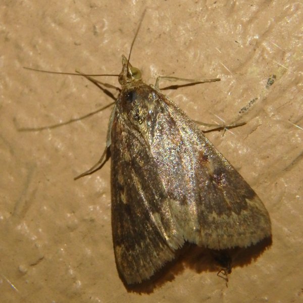
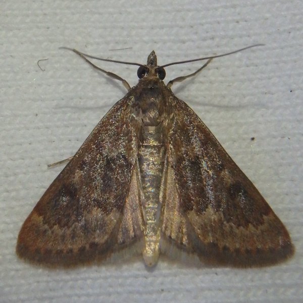
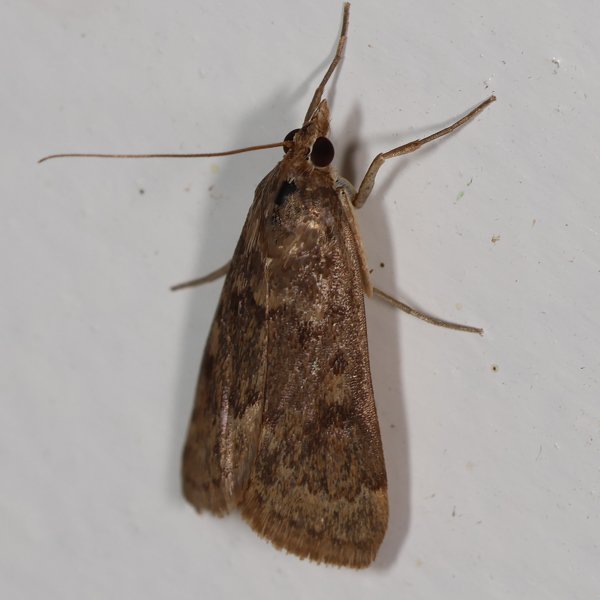
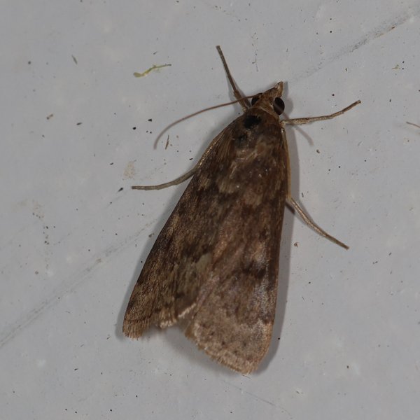
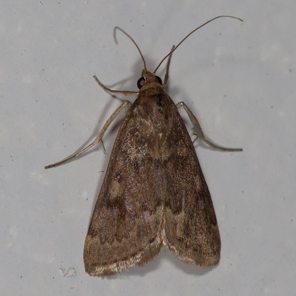
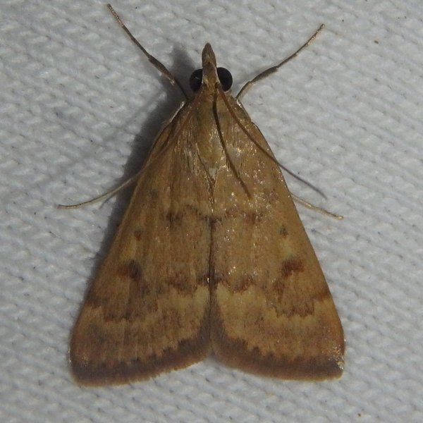
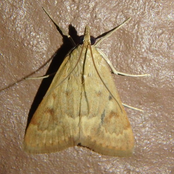
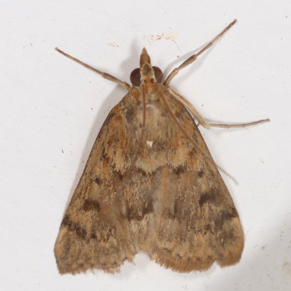
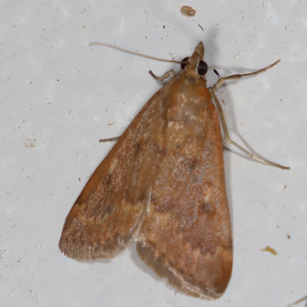
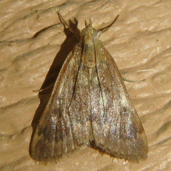
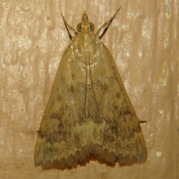
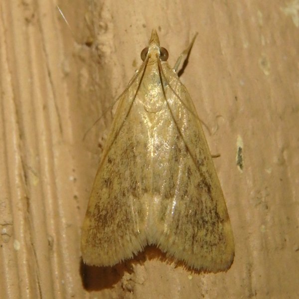
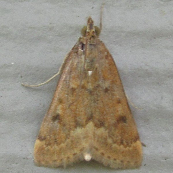
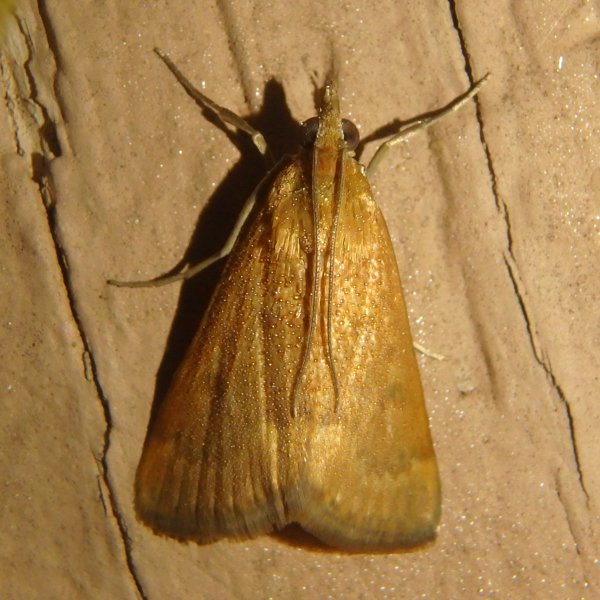
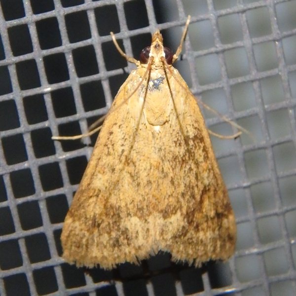
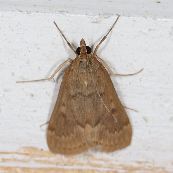
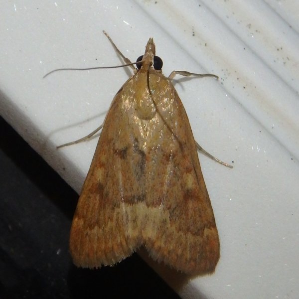
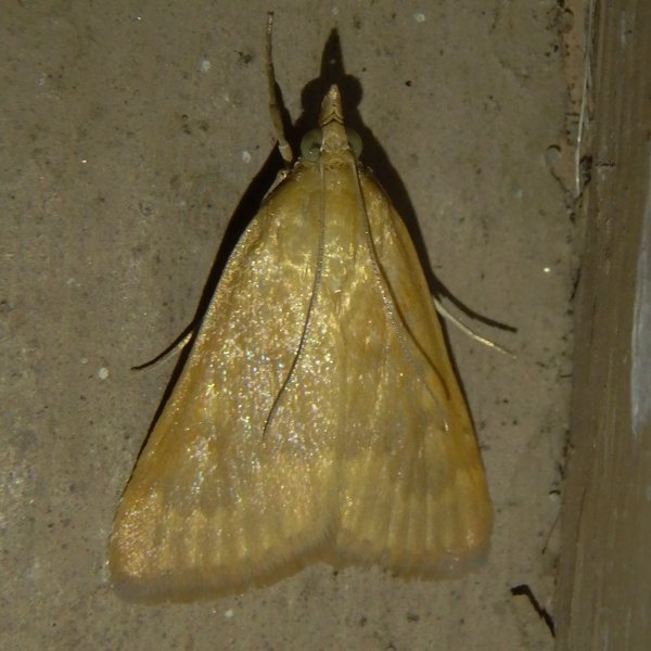
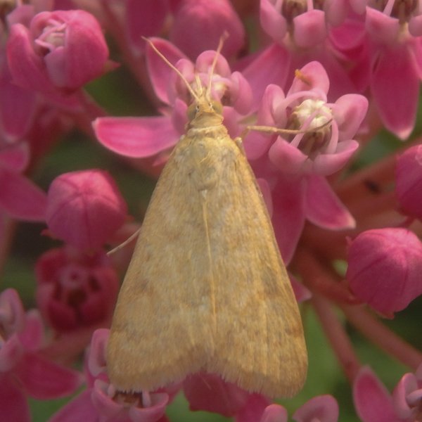
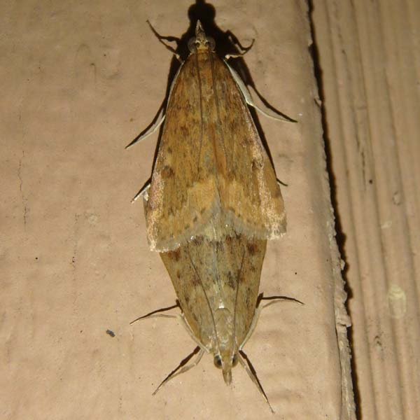
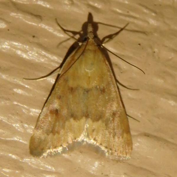
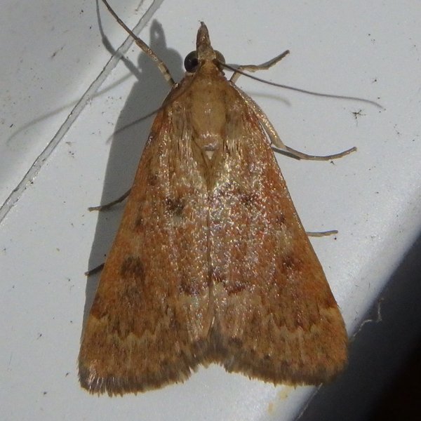
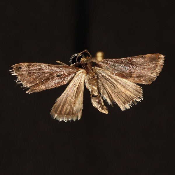
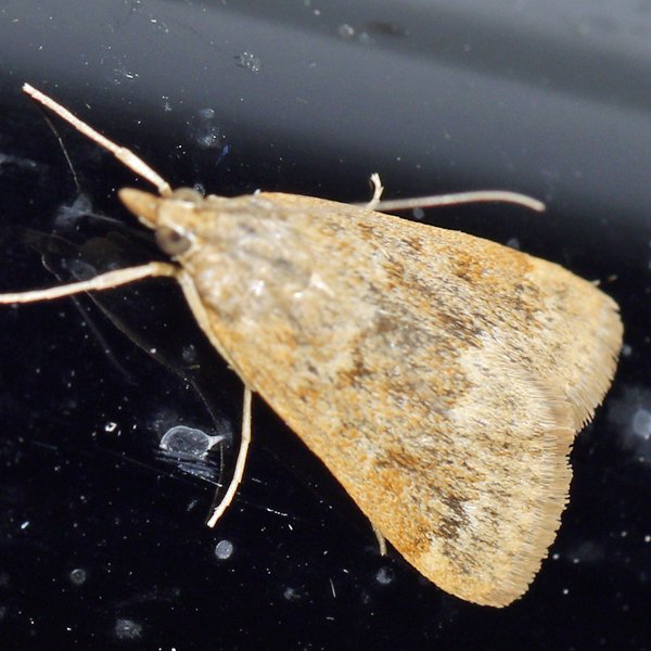
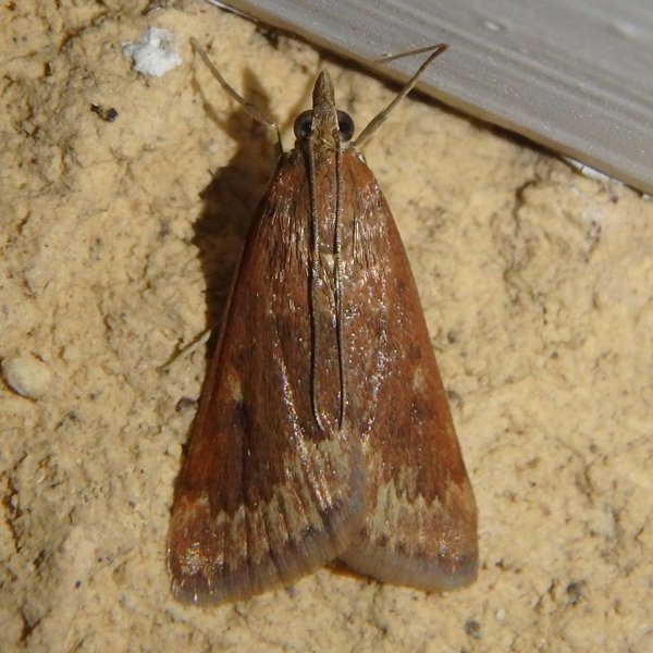
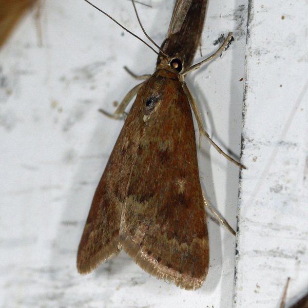
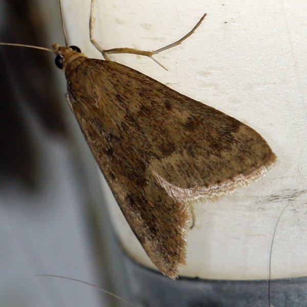
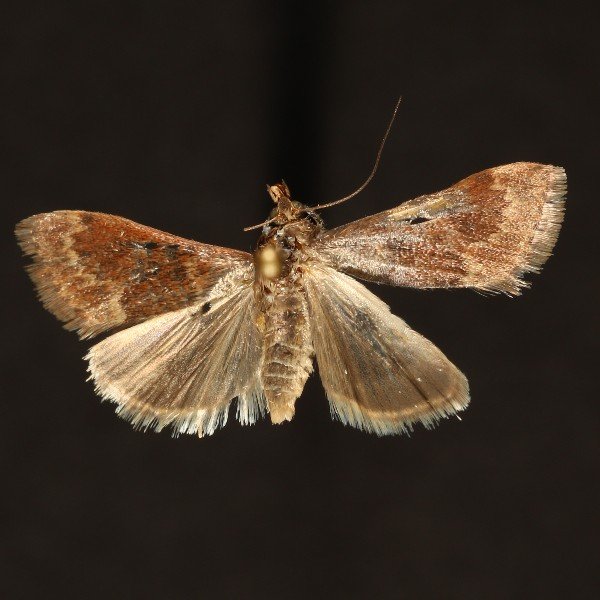
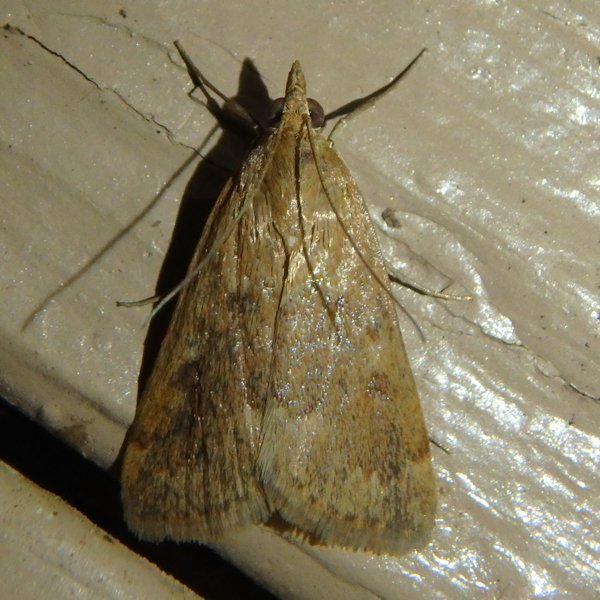
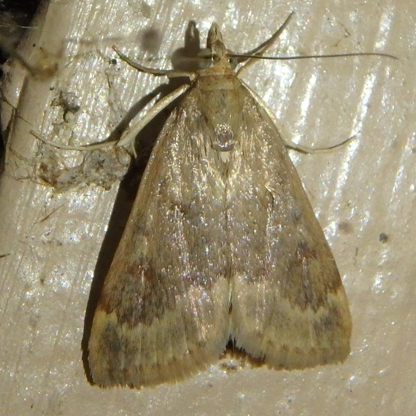
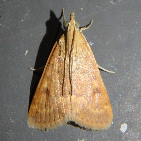
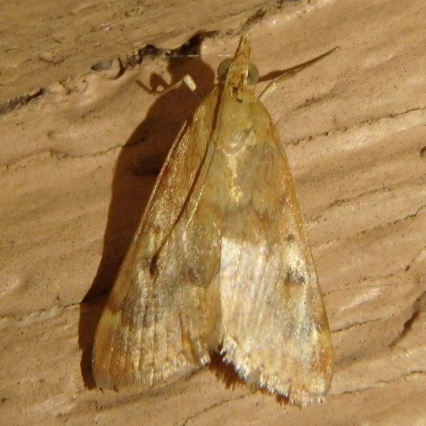
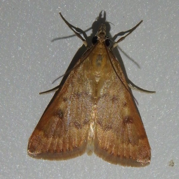
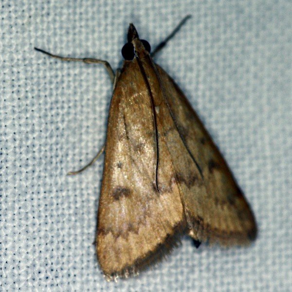
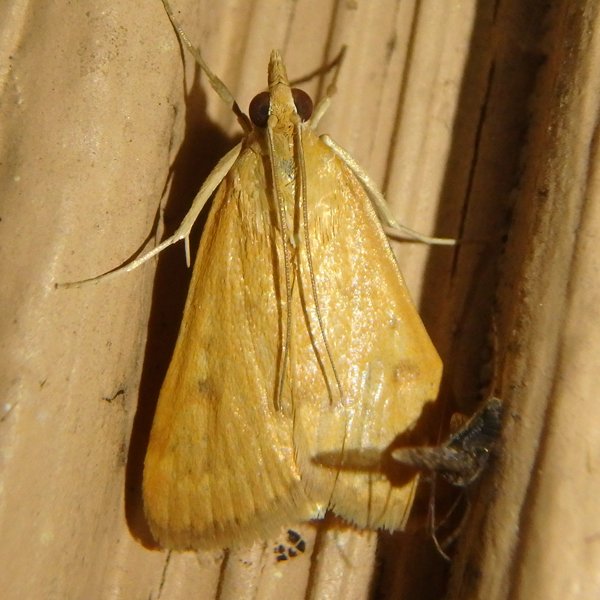
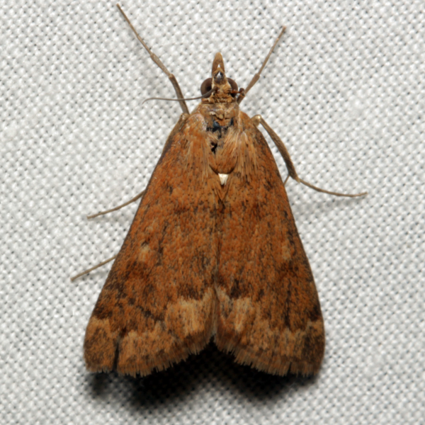
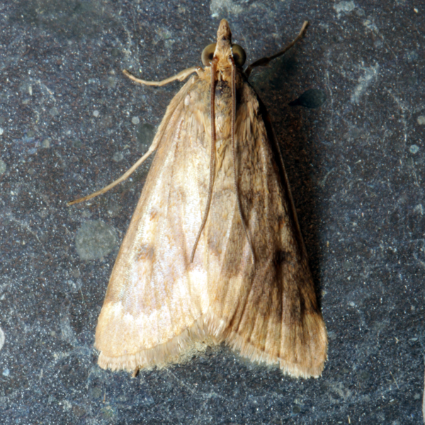
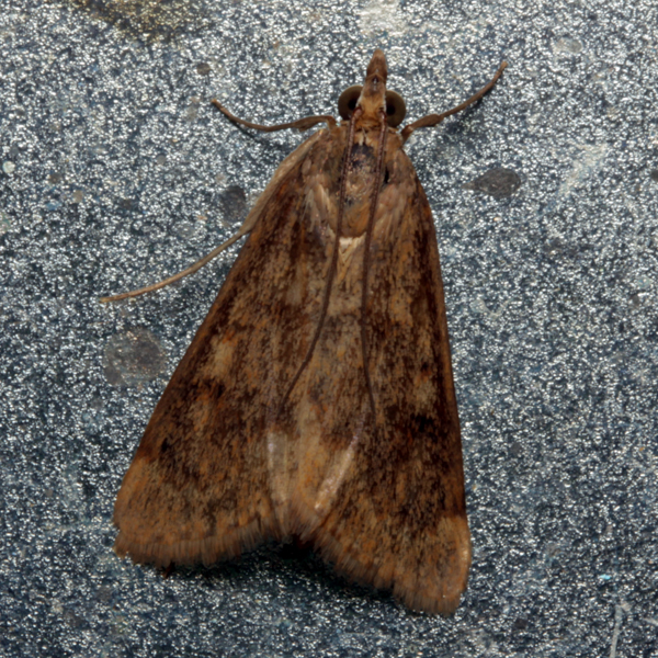
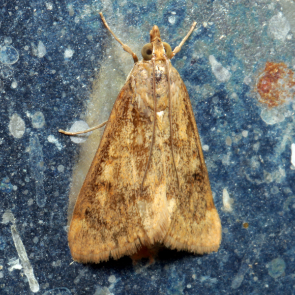
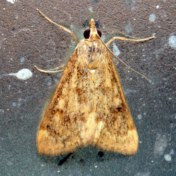
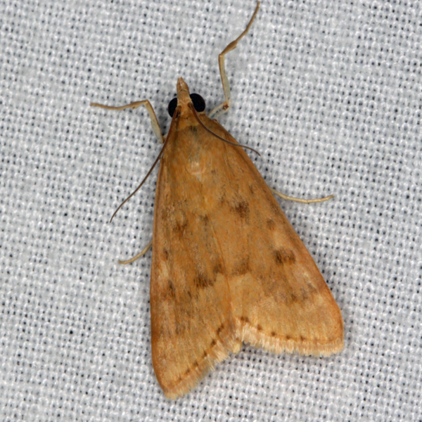
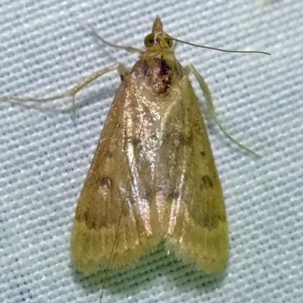
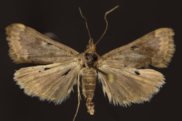
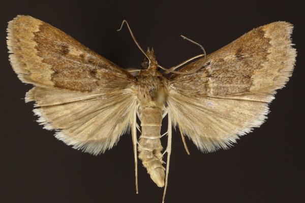
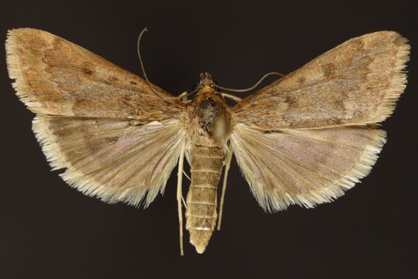
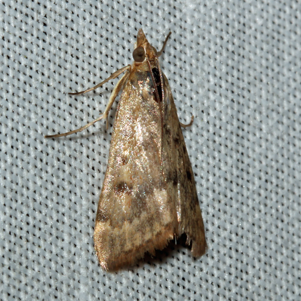
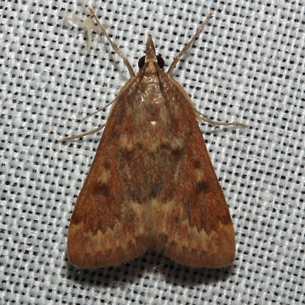
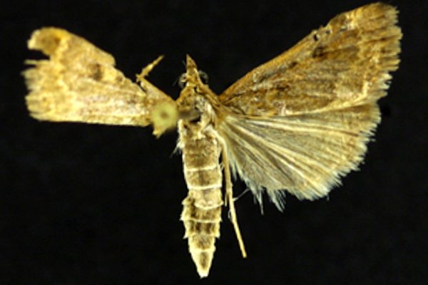
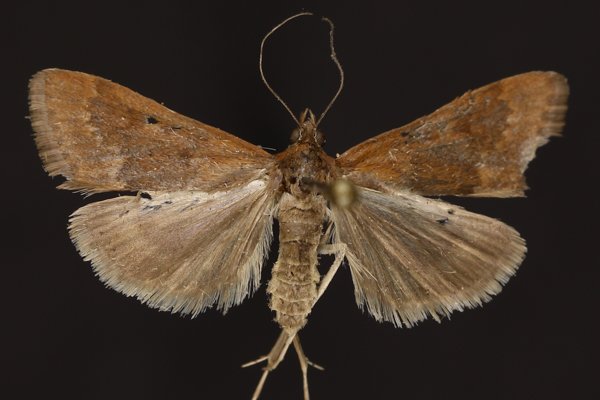
Garden Webworm Moth (Achyra rantalis), (Guenee, 1854) - 4975.000000 - 80a0742
Identification:
Wing Span: 16mm
Life History:
Flight:
Caterpillar Hosts:
Adult Food:
Habitat:
Conservation:
NCGR:
Management Needs:


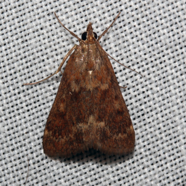
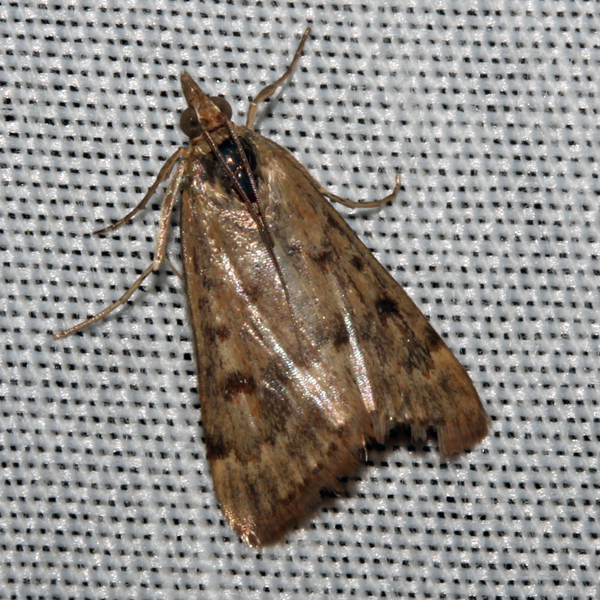
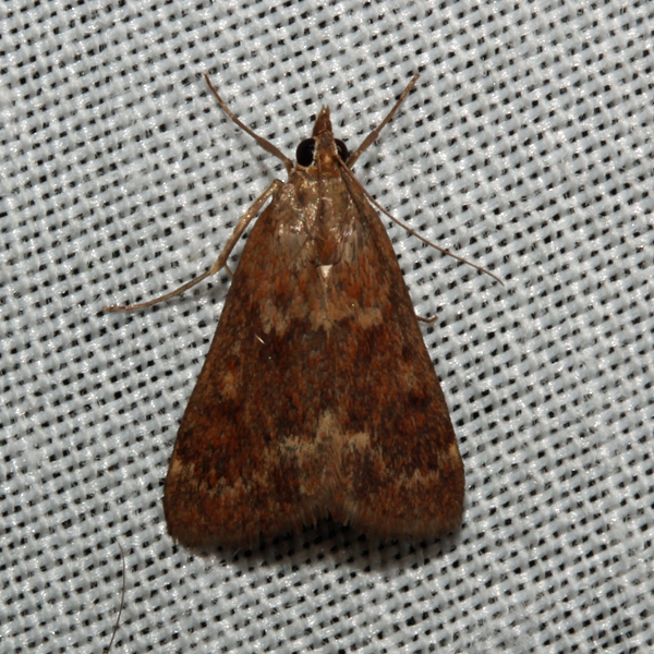
Photos


Records
| Record # | Date | Locale | State | Lat/Lon | Collected By | Count |
|---|---|---|---|---|---|---|
 332527 332527
|
2022-09-21 | MacBride Nature Recreation Area | Iowa | 41.786914743333334 -91.56851765 | Mark Brown | 1 |
 332658 332658
|
2022-09-16 | Johnson County, Iowa | Iowa | Location Protected | Mark Brown | 1 |
 314690 314690
|
2022-09-15 | Matsell Bridge Natural Area | Iowa | 42.13206715 -91.38532979 | Jim Durbin | 1 |
 314696 314696
|
2022-09-15 | Matsell Bridge Natural Area | Iowa | 42.13206715 -91.38532979 | Jim Durbin | 1 |
 314725 314725
|
2022-09-15 | Matsell Bridge Natural Area | Iowa | 42.13206715 -91.38532979 | Jim Durbin | 1 |
 332734 332734
|
2022-09-12 | Johnson County, Iowa | Iowa | Location Protected | Mark Brown | 1 |
 332981 332981
|
2022-09-02 | Trestle Trail, Thai Village, Des Moines | Iowa | 41.634921768333335 -93.65189696833333 | Mark Brown | 1 |
 314086 314086
|
2022-08-30 | F. W. Kent Park | Iowa | 41.73491755 -91.72195511 | Jim Durbin | 1 |
 314160 314160
|
2022-08-30 | F. W. Kent Park | Iowa | 41.73491755 -91.72195511 | Jim Durbin | 1 |
 333005 333005
|
2022-08-29 | MacBride Nature Recreation Area | Iowa | 41.78690624833333 -91.56850041333334 | Mark Brown | 1 |
 333014 333014
|
2022-08-28 | MacBride Nature Recreation Area | Iowa | 41.78690624833333 -91.56850041333334 | Mark Brown | 1 |
| 321479 | 2022-08-26 | Ames, Paul | Iowa | 42.011954 -93.615226 | Paul Martsching | 1 |
 332813 332813
|
2022-08-26 | MacBride Nature Recreation Area | Iowa | 41.78690624833333 -91.56850041333334 | Mark Brown | 1 |
 321154 321154
|
2022-08-25 | Willow Creek/Kiwanis Park | Iowa | 41.647924 -91.569677 | Peter Hansen | 1 |
 333165 333165
|
2022-08-22 | MacBride Nature Recreation Area | Iowa | 41.78690624833333 -91.56850041333334 | Mark Brown | 1 |
 333316 333316
|
2022-08-10 | MacBride Nature Recreation Area | Iowa | 41.78690624833333 -91.56850041333334 | Mark Brown | 1 |
 332384 332384
|
2022-08-07 | Johnson County, Iowa | Iowa | Location Protected | Mark Brown | 1 |
 312582 312582
|
2022-07-26 | Hitaga Sand Ridge Prairie Preserve | Iowa | 42.25103779 -91.63215575 | Jim Durbin | 1 |
 319618 319618
|
2022-07-04 | Johnson County, Iowa | Iowa | Location Protected | Mark Brown | 1 |
| 298750 | 2021-09-11 | Ames, Paul | Iowa | 42.011732 -93.615039 | Paul Martsching | 2 |
| 298708 | 2021-08-30 | Ames, Paul | Iowa | 42.011732 -93.615039 | Paul Martsching | 1 |
 296544 296544
|
2021-08-23 | MacBride Nature Recreation Area | Iowa | 41.78675752 -91.56846026 | Mark Brown | 1 |
 296802 296802
|
2021-08-08 | Cedar River Crossing Conservation Area | Iowa | 41.84033563 -91.39896647 | Mark Brown | 1 |
 272357 272357
|
2020-08-27 | Sugar Bottom Recreational Area | Iowa | 41.75721225 -91.55870061 | Mark Brown | 1 |
| 278216 | 2020-08-25 | Ames, Paul | Iowa | 42.012366 -93.613528 | Paul Martsching | 1 |
| 278215 | 2020-08-24 | Ames, Paul | Iowa | 42.012366 -93.613528 | Paul Martsching | 1 |
| 242083 | 2019-10-09 | Ames, Paul | Iowa | 42.02064 -93.623952 | Paul Martsching | 1 |
| 242082 | 2019-09-27 | Ames, Paul | Iowa | 42.02064 -93.623952 | Paul Martsching | 2 |
 240279 240279
|
2019-09-26 | Johnson County, Iowa | Iowa | Location Protected | Mark Brown | 1 |
| 242081 | 2019-09-24 | Ames, Paul | Iowa | 42.02064 -93.623952 | Paul Martsching | 3 |
| 242080 | 2019-09-21 | Ames, Paul | Iowa | 42.02064 -93.623952 | Paul Martsching | 1 |
| 242079 | 2019-09-18 | Ames, Paul | Iowa | 42.02064 -93.623952 | Paul Martsching | 4 |
| 242078 | 2019-09-17 | Ames, Paul | Iowa | 42.02064 -93.623952 | Paul Martsching | 2 |
| 242077 | 2019-09-16 | Ames, Paul | Iowa | 42.02064 -93.623952 | Paul Martsching | 3 |
 238476 238476
|
2019-09-11 | Johnson County, Iowa | Iowa | Location Protected | Mark Brown | 1 |
 238527 238527
|
2019-09-11 | MacBride Nature Recreation Area | Iowa | 41.786729 -91.568057 | Mark Brown | 1 |
 238538 238538
|
2019-09-10 | MacBride Nature Recreation Area | Iowa | 41.786729 -91.568057 | Mark Brown | 1 |
 238262 238262
|
2019-09-06 | Johnson County, Iowa | Iowa | Location Protected | Mark Brown | 1 |
 239972 239972
|
2019-09-03 | Ames, Paul | Iowa | 42.02064 -93.623952 | Paul Martsching | 1 |
| 242076 | 2019-09-03 | Ames, Paul | Iowa | 42.02064 -93.623952 | Paul Martsching | 4 |
 237918 237918
|
2019-09-02 | Matsell Bridge Natural Area | Iowa | 42.131959 -91.388307 | Jim Durbin | 1 |
| 242075 | 2019-09-02 | Ames, Paul | Iowa | 42.02064 -93.623952 | Paul Martsching | 10 |
 238269 238269
|
2019-09-01 | Polk County, Iowa | Iowa | Location Protected | Mark Brown | 1 |
| 242074 | 2019-08-31 | Ames, Paul | Iowa | 42.02064 -93.623952 | Paul Martsching | 8 |
| 242073 | 2019-08-30 | Ames, Paul | Iowa | 42.02064 -93.623952 | Paul Martsching | 11 |
 237311 237311
|
2019-08-29 | Vecny Woods | Iowa | 41.956725 -91.600854 | Jim Durbin | 1 |
 237416 237416
|
2019-08-29 | Vecny Woods | Iowa | 41.956725 -91.600854 | Jim Durbin | 1 |
| 242072 | 2019-08-29 | Ames, Paul | Iowa | 42.02064 -93.623952 | Paul Martsching | 3 |
 239973 239973
|
2019-08-26 | Ames, Paul | Iowa | 42.02064 -93.623952 | Paul Martsching | 1 |
| 242071 | 2019-08-26 | Ames, Paul | Iowa | 42.02064 -93.623952 | Paul Martsching | 2 |
| 242070 | 2019-08-25 | Ames, Paul | Iowa | 42.02064 -93.623952 | Paul Martsching | 2 |
 237026 237026
|
2019-08-24 | MacBride Nature Recreation Area | Iowa | 41.786729 -91.568057 | Mark Brown | 1 |
 237061 237061
|
2019-08-24 | MacBride Nature Recreation Area | Iowa | 41.786729 -91.568057 | Mark Brown | 1 |
 237067 237067
|
2019-08-24 | MacBride Nature Recreation Area | Iowa | 41.786729 -91.568057 | Mark Brown | 1 |
 237091 237091
|
2019-08-24 | MacBride Nature Recreation Area | Iowa | 41.786729 -91.568057 | Mark Brown | 1 |
| 242069 | 2019-08-24 | Ames, Paul | Iowa | 42.02064 -93.623952 | Paul Martsching | 2 |
| 242068 | 2019-08-23 | Ames, Paul | Iowa | 42.02064 -93.623952 | Paul Martsching | 7 |
 237188 237188
|
2019-08-21 | Johnson County, Iowa | Iowa | Location Protected | Mark Brown | 1 |
| 242067 | 2019-08-20 | Ames, Paul | Iowa | 42.02064 -93.623952 | Paul Martsching | 2 |
 237243 237243
|
2019-08-19 | Johnson County, Iowa | Iowa | Location Protected | Mark Brown | 1 |
| 242066 | 2019-08-19 | Ames, Paul | Iowa | 42.02064 -93.623952 | Paul Martsching | 3 |
| 242065 | 2019-08-17 | Ames, Paul | Iowa | 42.02064 -93.623952 | Paul Martsching | 3 |
| 242064 | 2019-08-16 | Ames, Paul | Iowa | 42.02064 -93.623952 | Paul Martsching | 1 |
| 242063 | 2019-08-10 | Ames, Paul | Iowa | 42.02064 -93.623952 | Paul Martsching | 2 |
 235526 235526
|
2019-08-08 | Pleasant Creek State Recreation Area, Linn County | Iowa | 42.109891 -91.826883 | Jim Durbin | 1 |
| 242062 | 2019-08-07 | Ames, Paul | Iowa | 42.02064 -93.623952 | Paul Martsching | 2 |
| 242061 | 2019-08-05 | Ames, Paul | Iowa | 42.02064 -93.623952 | Paul Martsching | 1 |
| 242060 | 2019-07-31 | Ames, Paul | Iowa | 42.02064 -93.623952 | Paul Martsching | 4 |
 235896 235896
|
2019-07-30 | Johnson County, Iowa | Iowa | Location Protected | Mark Brown | 1 |
| 234118 | 2019-07-29 | MacBride Nature Recreation Area | Iowa | 41.786729 -91.568057 | Mark Brown | 1 |
 235862 235862
|
2019-07-29 | MacBride Nature Recreation Area | Iowa | 41.786729 -91.568057 | Mark Brown | 1 |
| 242059 | 2019-07-19 | Ames, Paul | Iowa | 42.02064 -93.623952 | Paul Martsching | 1 |
| 223211 | 2018-09-20 | MacBride Nature Recreation Area | Iowa | 41.786729 -91.568057 | Mark Brown | 1 |
 221861 221861
|
2018-09-16 | 100 Acre Wood-x | Iowa | 0 0 | MJ Hatfield | 1 |
 221870 221870
|
2018-09-16 | 100 Acre Wood-x | Iowa | 0 0 | MJ Hatfield | 1 |
 221871 221871
|
2018-09-16 | 100 Acre Wood-x | Iowa | 0 0 | MJ Hatfield | 1 |
| 225887 | 2018-09-16 | Ames, Paul | Iowa | 42.02064 -93.623952 | Paul Martsching | 2 |
 221835 221835
|
2018-09-15 | 100 Acre Wood-x | Iowa | 0 0 | MJ Hatfield | 1 |
 221847 221847
|
2018-09-15 | 100 Acre Wood-x | Iowa | 0 0 | MJ Hatfield | 1 |
| 225886 | 2018-09-15 | Ames, Paul | Iowa | 42.02064 -93.623952 | Paul Martsching | 2 |
| 225885 | 2018-09-14 | Ames, Paul | Iowa | 42.02064 -93.623952 | Paul Martsching | 3 |
| 225884 | 2018-09-13 | Ames, Paul | Iowa | 42.02064 -93.623952 | Paul Martsching | 2 |
| 225883 | 2018-09-09 | Ames, Paul | Iowa | 42.02064 -93.623952 | Paul Martsching | 3 |
| 223134 | 2018-09-04 | MacBride Nature Recreation Area | Iowa | 41.786729 -91.568057 | Mark Brown | 1 |
| 220083 | 2018-08-24 | MacBride Nature Recreation Area | Iowa | 41.786729 -91.568057 | Mark Brown | 1 |
| 225882 | 2018-08-18 | Ames, Paul | Iowa | 42.02064 -93.623952 | Paul Martsching | 1 |
| 219917 | 2018-08-10 | MacBride Nature Recreation Area | Iowa | 41.786729 -91.568057 | Mark Brown | 1 |
| 225881 | 2018-08-07 | Ames, Paul | Iowa | 42.02064 -93.623952 | Paul Martsching | 1 |
| 225880 | 2018-08-03 | Ames, Paul | Iowa | 42.02064 -93.623952 | Paul Martsching | 2 |
| 225879 | 2018-07-30 | Ames, Paul | Iowa | 42.02064 -93.623952 | Paul Martsching | 1 |
| 197218 | 2017-10-16 | Ames, Paul | Iowa | 42.02064 -93.623952 | Paul Martsching | 1 |
| 196823 | 2017-09-25 | Ames, Paul | Iowa | 42.02064 -93.623952 | Paul Martsching | 1 |
 208580 208580
|
2017-09-24 | 100 Acre Wood-x | Iowa | 0 0 | MJ Hatfield | 1 |
| 196822 | 2017-09-22 | Ames, Paul | Iowa | 42.02064 -93.623952 | Paul Martsching | 2 |
| 196821 | 2017-09-20 | Ames, Paul | Iowa | 42.02064 -93.623952 | Paul Martsching | 1 |
| 196820 | 2017-09-14 | Ames, Paul | Iowa | 42.02064 -93.623952 | Paul Martsching | 1 |
| 196819 | 2017-09-13 | Ames, Paul | Iowa | 42.02064 -93.623952 | Paul Martsching | 1 |
| 196818 | 2017-09-12 | Ames, Paul | Iowa | 42.02064 -93.623952 | Paul Martsching | 3 |
| 196817 | 2017-09-03 | Ames, Paul | Iowa | 42.02064 -93.623952 | Paul Martsching | 1 |
| 196816 | 2017-09-02 | Ames, Paul | Iowa | 42.02064 -93.623952 | Paul Martsching | 1 |
| 196815 | 2017-08-31 | Ames, Paul | Iowa | 42.02064 -93.623952 | Paul Martsching | 1 |
| 196814 | 2017-08-30 | Ames, Paul | Iowa | 42.02064 -93.623952 | Paul Martsching | 1 |
| 196813 | 2017-08-01 | Ames, Paul | Iowa | 42.02064 -93.623952 | Paul Martsching | 1 |
 200447 200447
|
2017-07-30 | Hitchcock Nature Center | Iowa | 41.41733 -95.85388 | Loren & Babs Padelford | 1 |
 201574 201574
|
2017-07-27 | Jefferson County Park | Iowa | 40.98639 -91.99111 | Moni Hayne | 1 |
| 181611 | 2016-10-31 | Ames, Paul | Iowa | 42.02064 -93.623952 | Paul Martsching | 1 |
| 177595 | 2016-10-01 | Ames, Paul | Iowa | 42.02064 -93.623952 | Paul Martsching | 2 |
| 177594 | 2016-08-28 | Ames, Paul | Iowa | 42.02064 -93.623952 | Paul Martsching | 1 |
 176862 176862
|
2016-08-27 | Ames, Paul | Iowa | 42.02064 -93.623952 | Paul Martsching | 1 |
| 177593 | 2016-08-25 | Ames, Paul | Iowa | 42.02064 -93.623952 | Paul Martsching | 2 |
| 177592 | 2016-08-18 | Ames, Paul | Iowa | 42.02064 -93.623952 | Paul Martsching | 1 |
| 177591 | 2016-08-15 | Ames, Paul | Iowa | 42.02064 -93.623952 | Paul Martsching | 1 |
| 177590 | 2016-08-03 | Ames, Paul | Iowa | 42.02064 -93.623952 | Paul Martsching | 1 |
 176863 176863
|
2016-07-31 | Ames, Paul | Iowa | 42.02064 -93.623952 | Paul Martsching | 1 |
 184985 184985
|
2016-07-27 | Jefferson County Park | Iowa | 40.98639 -91.99111 | Moni Hayne | 1 |
| 131571 | 2015-09-04 | Ames, Paul | Iowa | 42.02064 -93.623952 | Paul Martsching | 2 |
 131583 131583
|
2015-05-14 | Ames, Paul | Iowa | 42.02064 -93.623952 | Paul Martsching | 1 |
| 168581 | 2014-10-24 | Ames, Paul | Iowa | 42.02064 -93.62395 | Paul Martsching | 1 |
| 168580 | 2014-09-30 | Ames, Paul | Iowa | 42.02064 -93.62395 | Paul Martsching | 1 |
| 168579 | 2014-09-21 | Ames, Paul | Iowa | 42.02064 -93.62395 | Paul Martsching | 1 |
 309291 309291
|
2014-09-20 | Minne Estema Park | Iowa | 42.258877 -92.020061 | Frank Olsen | 1 |
| 168578 | 2014-09-13 | Ames, Paul | Iowa | 42.02064 -93.62395 | Paul Martsching | 1 |
| 168577 | 2014-09-04 | Ames, Paul | Iowa | 42.02064 -93.62395 | Paul Martsching | 1 |
| 168576 | 2014-08-30 | Ames, Paul | Iowa | 42.02064 -93.62395 | Paul Martsching | 1 |
| 168575 | 2014-08-20 | Ames, Paul | Iowa | 42.02064 -93.62395 | Paul Martsching | 1 |
| 168574 | 2014-08-12 | Ames, Paul | Iowa | 42.02064 -93.62395 | Paul Martsching | 1 |
| 168573 | 2014-08-03 | Ames, Paul | Iowa | 42.02064 -93.62395 | Paul Martsching | 1 |
| 168572 | 2014-07-15 | Ames, Paul | Iowa | 42.02064 -93.62395 | Paul Martsching | 1 |
| 168571 | 2014-06-22 | Ames, Paul | Iowa | 42.02064 -93.62395 | Paul Martsching | 1 |
 12656 12656
|
2013-10-02 | Hickory Ridge Woods | Iowa | 43.31803 -91.79667 | Kirk Larsen | 1 |
 12657 12657
|
2013-10-02 | Hickory Ridge Woods | Iowa | 43.31803 -91.79667 | Kirk Larsen | 1 |
| 110793 | 2013-10-01 | Polk County, Iowa | Iowa | Location Protected | Aaron Brees | 1 |
| 110792 | 2013-09-12 | Polk County, Iowa | Iowa | Location Protected | Aaron Brees | 1 |
| 110791 | 2013-08-31 | Polk County, Iowa | Iowa | Location Protected | Aaron Brees | 1 |
 66365 66365
|
2013-08-27 | Near Fairfield | Iowa | 41.0503 -92.024 | Moni Hayne | 1 |
| 110790 | 2013-08-25 | Polk County, Iowa | Iowa | Location Protected | Aaron Brees | 1 |
| 110789 | 2013-08-22 | Polk County, Iowa | Iowa | Location Protected | Aaron Brees | 1 |
| 110788 | 2013-08-13 | Polk County, Iowa | Iowa | Location Protected | Aaron Brees | 1 |
| 110787 | 2013-08-07 | Polk County, Iowa | Iowa | Location Protected | Aaron Brees | 1 |
 12661 12661
|
2013-08-06 | Johnson County, Iowa | Iowa | Location Protected | Mark Brown | 1 |
| 110786 | 2013-08-06 | Polk County, Iowa | Iowa | Location Protected | Aaron Brees | 1 |
| 110785 | 2013-08-02 | Polk County, Iowa | Iowa | Location Protected | Aaron Brees | 1 |
| 110784 | 2013-07-26 | Polk County, Iowa | Iowa | Location Protected | Aaron Brees | 1 |
| 110783 | 2013-07-25 | Polk County, Iowa | Iowa | Location Protected | Aaron Brees | 1 |
| 110782 | 2013-07-23 | Polk County, Iowa | Iowa | Location Protected | Aaron Brees | 1 |
 12655 12655
|
2013-07-12 | Whiterock Conservancy | Iowa | 41.80725 -94.64085 | Jim Durbin | 1 |
 48347 48347
|
2013-07-12 | Whiterock Conservancy | Iowa | 41.80725 -94.64085 | Jim Durbin | 1 |
 12649 12649
|
2012-09-08 | Waubonsie State Park | Iowa | 40.676 -95.689 | Tom Jantscher | 1 |
 66635 66635
|
2012-09-03 | 100 Acre Wood-x | Iowa | 0 0 | MJ Hatfield | 1 |
 66636 66636
|
2012-09-03 | 100 Acre Wood-x | Iowa | 0 0 | MJ Hatfield | 1 |
 146064 146064
|
2012-09-03 | 100 Acre Wood-x | Iowa | 0 0 | MJ Hatfield | 1 |
 146065 146065
|
2012-09-03 | 100 Acre Wood-x | Iowa | 0 0 | MJ Hatfield | 1 |
 12651 12651
|
2012-08-14 | Wickiup Hill Outdoor Learning Area | Iowa | 42.08398 -91.7651 | Frank Olsen | 1 |
 12648 12648
|
2012-08-04 | 5031 Old Lyddane Bridge Road | Kentucky | 37.746807 -87.185997 | Jim Durbin | 1 |
 48334 48334
|
2012-08-04 | 5031 Old Lyddane Bridge Road | Kentucky | 37.746807 -87.185997 | Jim Durbin | 1 |
 67187 67187
|
2012-08-01 | 100 Acre Wood-x | Iowa | 0 0 | MJ Hatfield | 1 |
 12658 12658
|
2012-07-30 | Marshall County, Iowa | Iowa | Location Protected | Carl Kurtz | 1 |
 12646 12646
|
2012-07-29 | Matsell Bridge Natural Area | Iowa | 42.13131 -91.38886 | Jim Durbin | 1 |
| 12647 | 2012-07-26 | Ambrose A. Call State Park | Iowa | 43.0517 -94.2498 | Matt Kenne | 1 |
 12659 12659
|
2012-07-25 | Jefferson County Park | Iowa | 40.98639 -91.99111 | Moni Hayne | 1 |
 12644 12644
|
2012-07-19 | Wanatee County Park | Iowa | 42.01026 -91.57381 | Jim Durbin | 1 |
 12645 12645
|
2012-07-19 | Wanatee County Park | Iowa | 42.01026 -91.57381 | Jim Durbin | 1 |
 12650 12650
|
2012-07-04 | Iowa City | Iowa | 41.667 -91.545 | Mark Brown | 1 |
| 39285 | 2012-06-15 | Matsell Bridge Natural Area | Iowa | 42.13131 -91.38886 | Jim Durbin | 1 |
 133621 133621
|
2011-10-15 | Ames, Paul | Iowa | 42.02064 -93.623952 | Paul Martsching | 1 |
 12643 12643
|
2011-08-23 | Near Fairfield | Iowa | 41.0503 -92.024 | Moni Hayne | 1 |
 12660 12660
|
2011-08-23 | Near Fairfield | Iowa | 41.0503 -92.024 | Moni Hayne | 1 |
| 12636 | 2011-05-23 | Wanatee County Park | Iowa | 42.0094 -91.56623 | Jim Durbin | 1 |
| 12640 | 2011-05-18 | Puccoon Prairie | Iowa | 41.73528 -93.36417 | Keith Summerville | 1 |
| 12641 | 2011-05-18 | Chichaqua Bottoms Sandhill Prairie | Iowa | 41.77278 -93.385 | Keith Summerville | 1 |
| 12642 | 2011-05-18 | Chichaqua Bottoms Sandhill Prairie | Iowa | 41.77167 -93.38361 | Keith Summerville | 1 |
 12605 12605
|
2010-08-19 | McIntosh Woods | Iowa | 43.12505 -93.4563 | Jim Durbin | 1 |
 12602 12602
|
2010-08-06 | Lost Island County Park | Iowa | 43.17582 -94.89189 | Jim Durbin | 1 |
 12601 12601
|
2010-08-05 | Waubonsie State Park | Iowa | 40.676 -95.689 | Jim Durbin | 1 |
 124913 124913
|
2010-08-05 | Waubonsie State Park | Iowa | 40.676 -95.689 | Jim Durbin | 1 |
 12594 12594
|
2009-08-12 | Warren County, Iowa | Iowa | Location Protected | John Pearson | 1 |
 12639 12639
|
2009-08-12 | Ackworth | Iowa | 41.36468 -93.48952 | John Pearson | 1 |
 12587 12587
|
2009-08-09 | Waubonsie State Park | Iowa | 40.676 -95.689 | Jim Durbin | 1 |
 12588 12588
|
2009-08-09 | Waubonsie State Park | Iowa | 40.676 -95.689 | Jim Durbin | 1 |
 12589 12589
|
2009-08-09 | Waubonsie State Park | Iowa | 40.676 -95.689 | Jim Durbin | 1 |
 12590 12590
|
2009-08-09 | Waubonsie State Park | Iowa | 40.676 -95.689 | Jim Durbin | 1 |
 12591 12591
|
2009-08-09 | Waubonsie State Park | Iowa | 40.676 -95.689 | Jim Durbin | 1 |
 12592 12592
|
2009-08-09 | Waubonsie State Park | Iowa | 40.676 -95.689 | Jim Durbin | 1 |
 12597 12597
|
2007-10-04 | Luther College | Iowa | 43.31333 -91.80306 | Ryan G | 1 |
| 355190 | 2007-10-04 | Spilde Woods | Iowa | 43.317783 -91.812417 | Ryan Goeken | 1 |
| 355191 | 2007-10-04 | Spilde Woods | Iowa | 43.317783 -91.812417 | Ryan Goeken | 1 |
 12577 12577
|
2007-09-17 | 1460 Douglas Ct, Marion | Iowa | 42.040069 -91.590953 | Jim Durbin | 1 |
 12578 12578
|
2007-09-17 | 1460 Douglas Ct, Marion | Iowa | 42.040069 -91.590953 | Jim Durbin | 1 |
 12574 12574
|
2007-09-09 | Indian Lake Park, Farmington | Iowa | 40.63518 -91.75017 | Jim Durbin | 1 |
 12572 12572
|
2007-08-20 | 1460 Douglas Ct, Marion | Iowa | 42.040069 -91.590953 | Jim Durbin | 1 |
 12573 12573
|
2007-08-20 | 1460 Douglas Ct, Marion | Iowa | 42.040069 -91.590953 | Jim Durbin | 1 |
 12570 12570
|
2007-08-17 | Wanatee County Park | Iowa | 42.0094 -91.56623 | Jim Durbin | 1 |
 12571 12571
|
2007-08-15 | 1460 Douglas Ct, Marion | Iowa | 42.040069 -91.590953 | Jim Durbin | 1 |
 133496 133496
|
2006-07-09 | Ames, Paul | Iowa | 42.02064 -93.623952 | Paul Martsching | 1 |
 133495 133495
|
2006-06-07 | Ames, Paul | Iowa | 42.02064 -93.623952 | Paul Martsching | 1 |
| 12569 | 2006-05-25 | Neal Smith National Wildlife Refuge | Iowa | 41.54245 -93.2908 | Keith Summerville | 1 |
| 12607 | 2006-05-25 | Neal Smith National Wildlife Refuge | Iowa | 41.54245 -93.2908 | Keith Summerville | 1 |
| 12612 | 2006-05-25 | Thomas Mitchell Park | Iowa | 41.64 -93.3823 | Keith Summerville | 1 |
| 12614 | 2006-05-25 | Puccoon Prairie | Iowa | 41.73528 -93.36417 | Keith Summerville | 1 |
| 12619 | 2006-05-25 | Chichaqua Bottoms Sandhill Prairie | Iowa | 41.77278 -93.385 | Keith Summerville | 1 |
| 12624 | 2006-05-25 | Glendale Cemetery | Iowa | 41.60889 -93.69167 | Keith Summerville | 1 |
| 12627 | 2006-05-25 | Neal Smith National Wildlife Refuge | Iowa | 41.57639 -93.265 | Keith Summerville | 1 |
| 12632 | 2006-05-25 | Yellow Banks Park | Iowa | 41.547615 -93.47527 | Keith Summerville | 1 |
| 69180 | 2006-05-25 | Thomas Mitchell Park | Iowa | 41.64 -93.3823 | Keith Summerville | 1 |
| 69182 | 2006-05-25 | Puccoon Prairie | Iowa | 41.73528 -93.36417 | Keith Summerville | 1 |
| 69186 | 2006-05-25 | Chichaqua Bottoms Sandhill Prairie | Iowa | 41.77278 -93.385 | Keith Summerville | 1 |
| 69191 | 2006-05-25 | Glendale Cemetery | Iowa | 41.60889 -93.69167 | Keith Summerville | 4 |
| 69194 | 2006-05-25 | Neal Smith National Wildlife Refuge | Iowa | 41.57639 -93.265 | Keith Summerville | 12 |
| 69199 | 2006-05-25 | Yellow Banks Park | Iowa | 41.547615 -93.47527 | Keith Summerville | 1 |
| 69200 | 2006-05-25 | Neal Smith National Wildlife Refuge | Iowa | 41.54245 -93.2908 | Keith Summerville | 1 |
 133494 133494
|
2005-08-30 | Ames, Paul | Iowa | 42.02064 -93.623952 | Paul Martsching | 1 |
| 12609 | 2005-05-25 | Big Creek State Park | Iowa | 41.807055 -93.745185 | Keith Summerville | 1 |
| 12611 | 2005-05-25 | Thomas Mitchell Park | Iowa | 41.64 -93.3823 | Keith Summerville | 1 |
| 12613 | 2005-05-25 | Puccoon Prairie | Iowa | 41.73528 -93.36417 | Keith Summerville | 1 |
| 12615 | 2005-05-25 | Synder Farm INHF | Iowa | 41.76675 -93.484171 | Keith Summerville | 1 |
| 12616 | 2005-05-25 | Synder Farm INHF | Iowa | 41.76675 -93.484171 | Keith Summerville | 1 |
| 12618 | 2005-05-25 | Chichaqua Bottoms Sandhill Prairie | Iowa | 41.77278 -93.385 | Keith Summerville | 1 |
| 12621 | 2005-05-25 | Paul Errington Marsh Wildlife Management Area | Iowa | 41.75611 -93.50556 | Keith Summerville | 1 |
| 12623 | 2005-05-25 | Glendale Cemetery | Iowa | 41.60889 -93.69167 | Keith Summerville | 1 |
| 12626 | 2005-05-25 | Neal Smith National Wildlife Refuge | Iowa | 41.57639 -93.265 | Keith Summerville | 1 |
| 12629 | 2005-05-25 | Saylorville Lake Site 1 KS | Iowa | 41.74944 -93.68139 | Keith Summerville | 1 |
| 69177 | 2005-05-25 | Big Creek State Park | Iowa | 41.807055 -93.745185 | Keith Summerville | 3 |
| 69179 | 2005-05-25 | Thomas Mitchell Park | Iowa | 41.64 -93.3823 | Keith Summerville | 1 |
| 69181 | 2005-05-25 | Puccoon Prairie | Iowa | 41.73528 -93.36417 | Keith Summerville | 2 |
| 69183 | 2005-05-25 | Synder Farm INHF | Iowa | 41.76675 -93.484171 | Keith Summerville | 2 |
| 69185 | 2005-05-25 | Chichaqua Bottoms Sandhill Prairie | Iowa | 41.77278 -93.385 | Keith Summerville | 1 |
| 69188 | 2005-05-25 | Paul Errington Marsh Wildlife Management Area | Iowa | 41.75611 -93.50556 | Keith Summerville | 1 |
| 69190 | 2005-05-25 | Glendale Cemetery | Iowa | 41.60889 -93.69167 | Keith Summerville | 1 |
| 69193 | 2005-05-25 | Neal Smith National Wildlife Refuge | Iowa | 41.57639 -93.265 | Keith Summerville | 3 |
| 69196 | 2005-05-25 | Big Creek State Park | Iowa | 41.81167 -93.75333 | Keith Summerville | 2 |
| 69198 | 2005-05-25 | Yellow Banks Park | Iowa | 41.547615 -93.47527 | Keith Summerville | 2 |
 308862 308862
|
2004-09-01 | Wickiup Hill Outdoor Learning Area | Iowa | 42.084015 -91.764838 | Frank Olsen | 1 |
| 12608 | 2004-05-25 | Big Creek State Park | Iowa | 41.807055 -93.745185 | Keith Summerville | 1 |
| 12610 | 2004-05-25 | Thomas Mitchell Park | Iowa | 41.64 -93.3823 | Keith Summerville | 1 |
| 12617 | 2004-05-25 | Chichaqua Bottoms Sandhill Prairie | Iowa | 41.77278 -93.385 | Keith Summerville | 1 |
| 12620 | 2004-05-25 | Paul Errington Marsh Wildlife Management Area | Iowa | 41.75611 -93.50556 | Keith Summerville | 1 |
| 12622 | 2004-05-25 | Glendale Cemetery | Iowa | 41.60889 -93.69167 | Keith Summerville | 1 |
| 12625 | 2004-05-25 | Neal Smith National Wildlife Refuge | Iowa | 41.57639 -93.265 | Keith Summerville | 1 |
| 12628 | 2004-05-25 | Saylorville Lake Site 1 KS | Iowa | 41.74944 -93.68139 | Keith Summerville | 1 |
| 12630 | 2004-05-25 | Yellow Banks Park | Iowa | 41.547615 -93.47527 | Keith Summerville | 1 |
| 69176 | 2004-05-25 | Big Creek State Park | Iowa | 41.807055 -93.745185 | Keith Summerville | 1 |
| 69178 | 2004-05-25 | Thomas Mitchell Park | Iowa | 41.64 -93.3823 | Keith Summerville | 1 |
| 69184 | 2004-05-25 | Chichaqua Bottoms Sandhill Prairie | Iowa | 41.77278 -93.385 | Keith Summerville | 1 |
| 69187 | 2004-05-25 | Paul Errington Marsh Wildlife Management Area | Iowa | 41.75611 -93.50556 | Keith Summerville | 1 |
| 69189 | 2004-05-25 | Glendale Cemetery | Iowa | 41.60889 -93.69167 | Keith Summerville | 1 |
| 69192 | 2004-05-25 | Neal Smith National Wildlife Refuge | Iowa | 41.57639 -93.265 | Keith Summerville | 1 |
| 69195 | 2004-05-25 | Big Creek State Park | Iowa | 41.81167 -93.75333 | Keith Summerville | 2 |
| 69197 | 2004-05-25 | Yellow Banks Park | Iowa | 41.547615 -93.47527 | Keith Summerville | 1 |
 133493 133493
|
2003-09-05 | Ames, Paul | Iowa | 42.02064 -93.623952 | Paul Martsching | 1 |