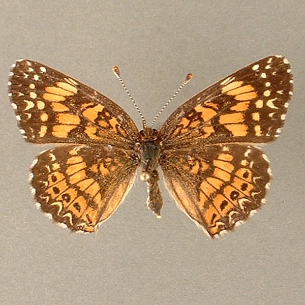
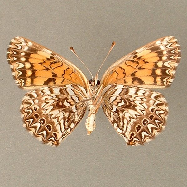
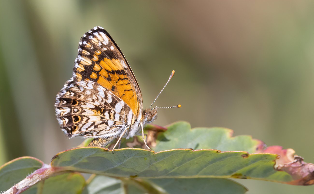
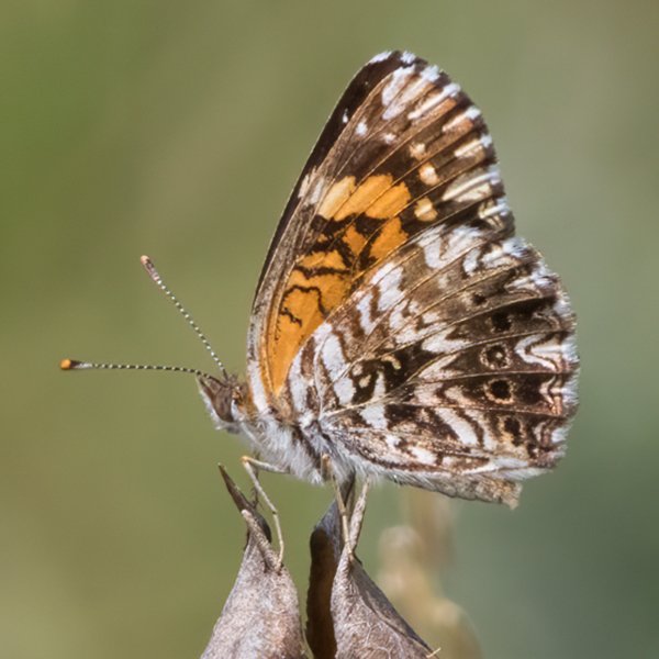
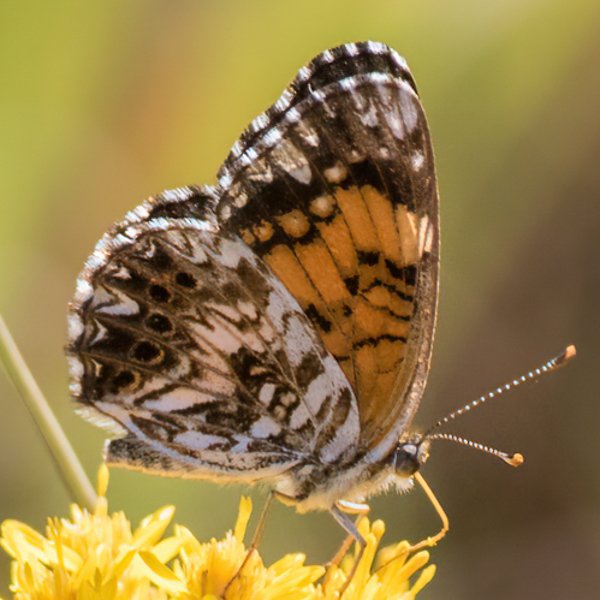
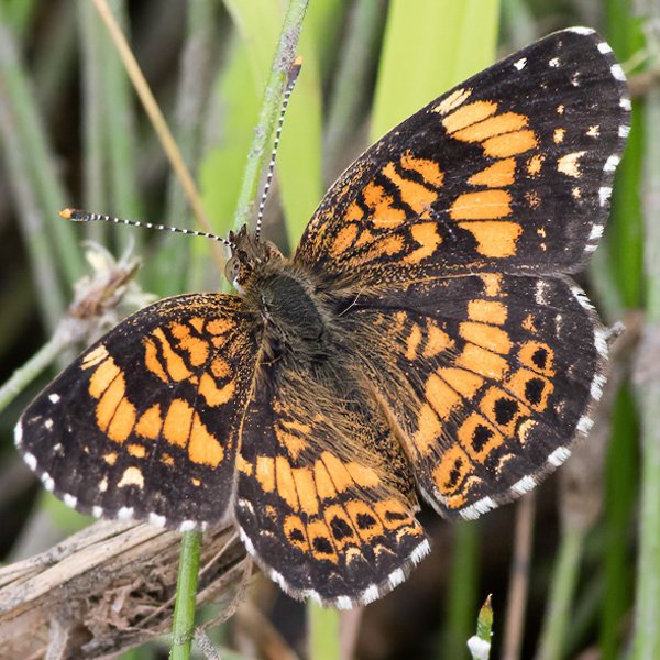
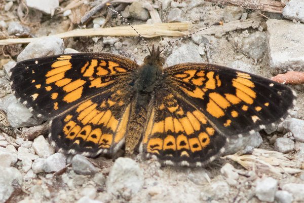
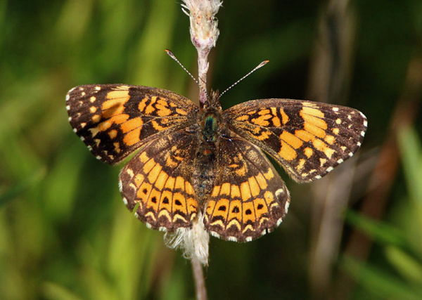
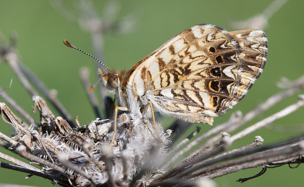
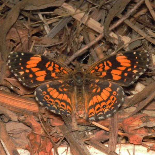
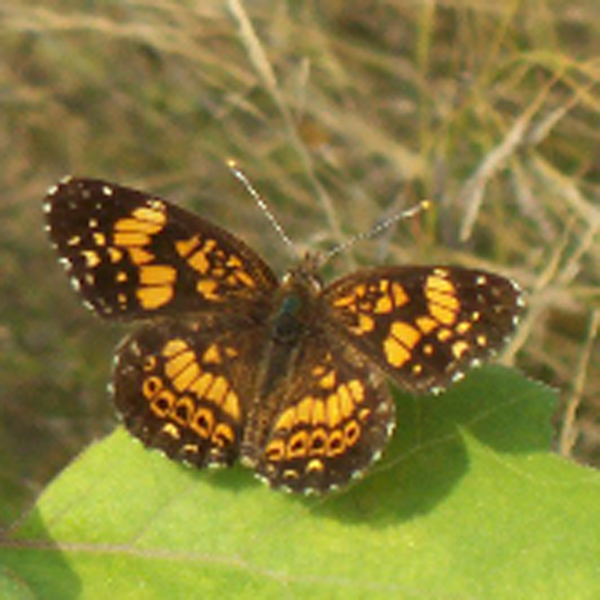
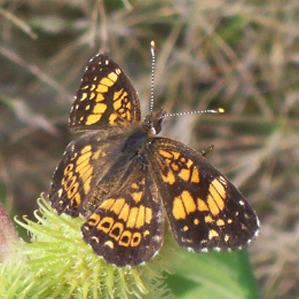
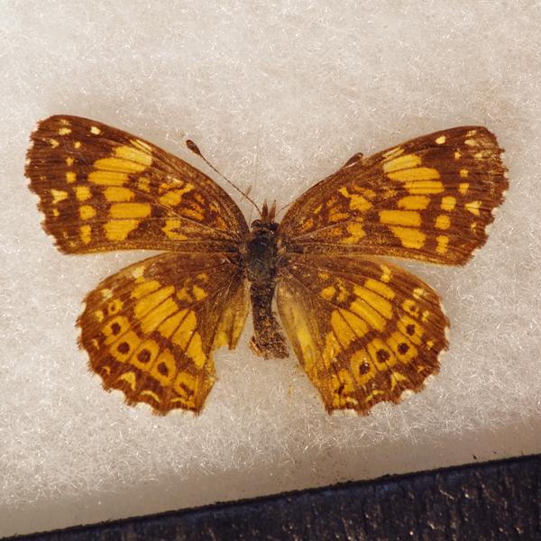
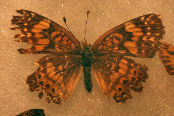
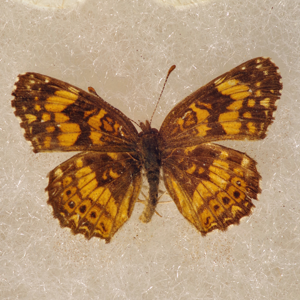
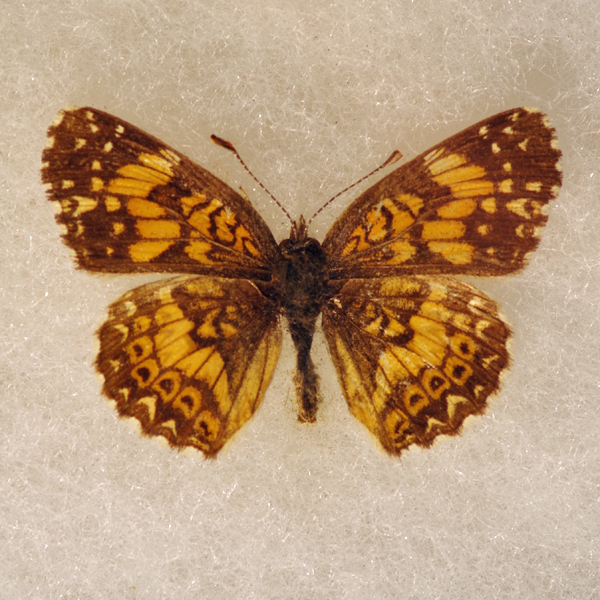
Wingspan: 2.8-3.5 cm.
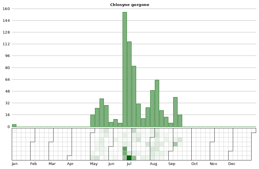
Flight time: Apparently three broods; the first emerging late-April to early-June; the second from late June to mid-July; and the third during August. A partial fourth brood emerges some years in late September.
Status: Breeding resident.
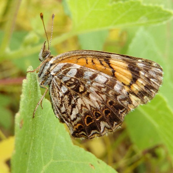
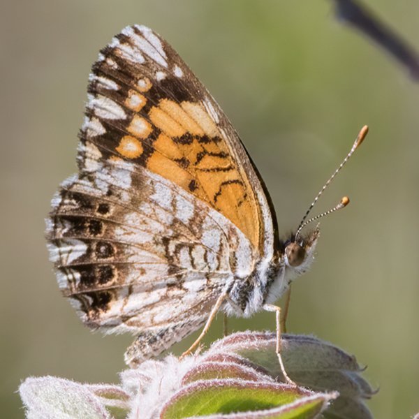
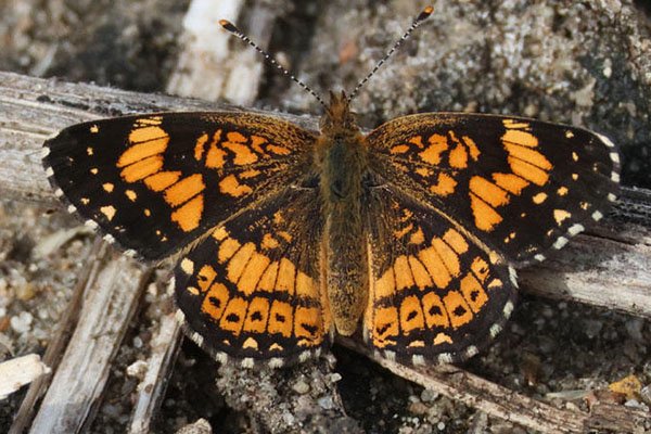
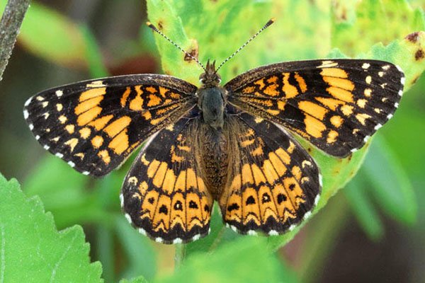
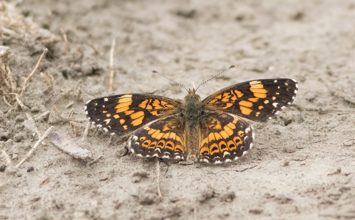
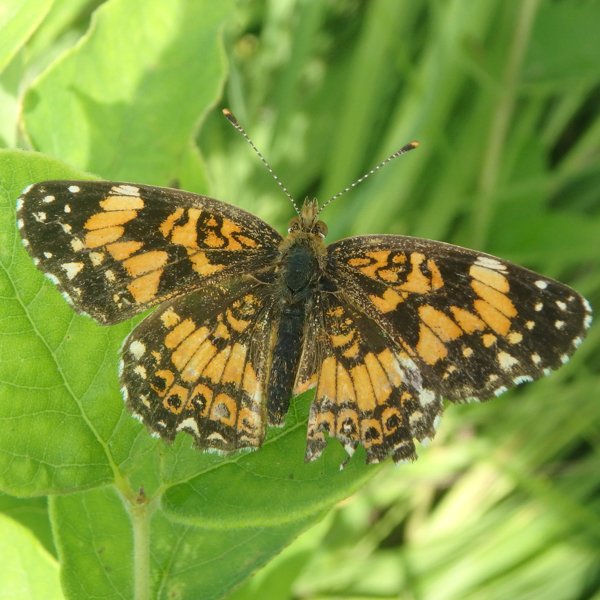
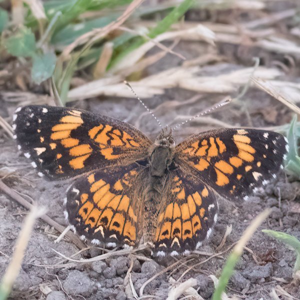
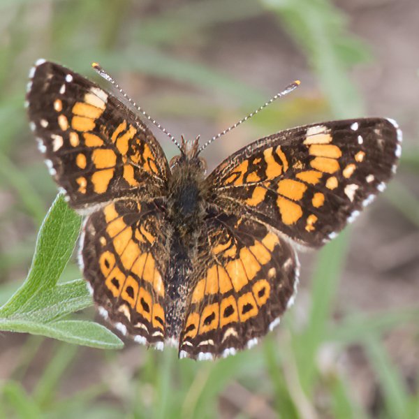
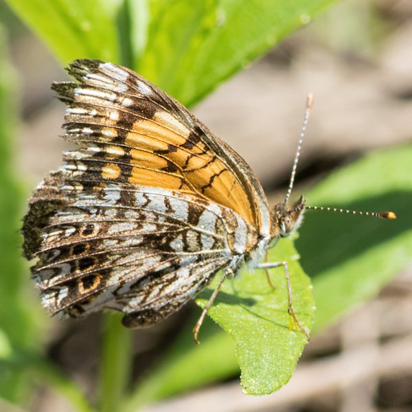
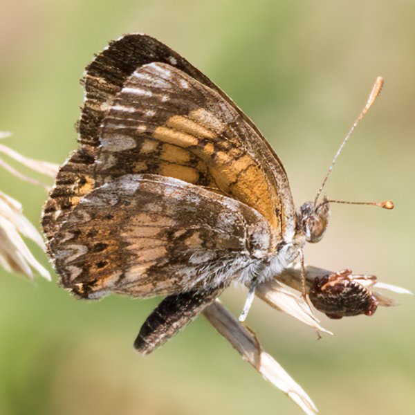
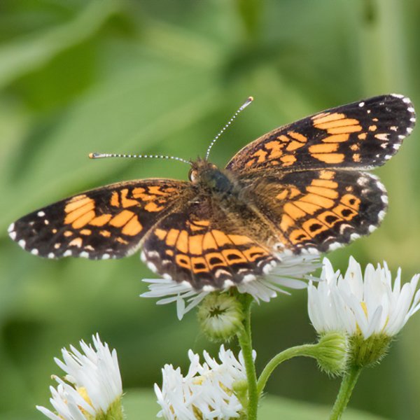
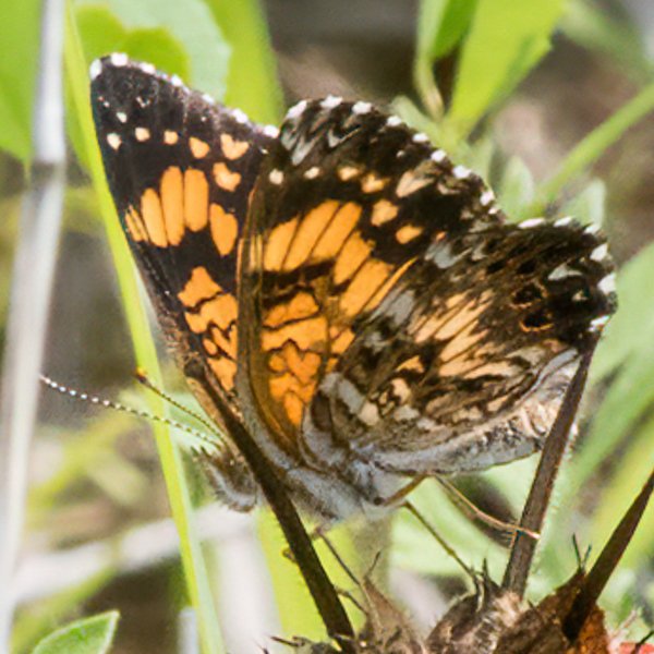
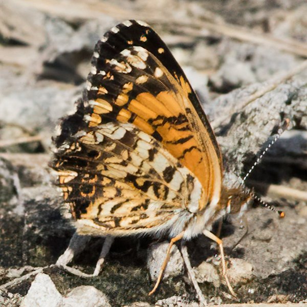
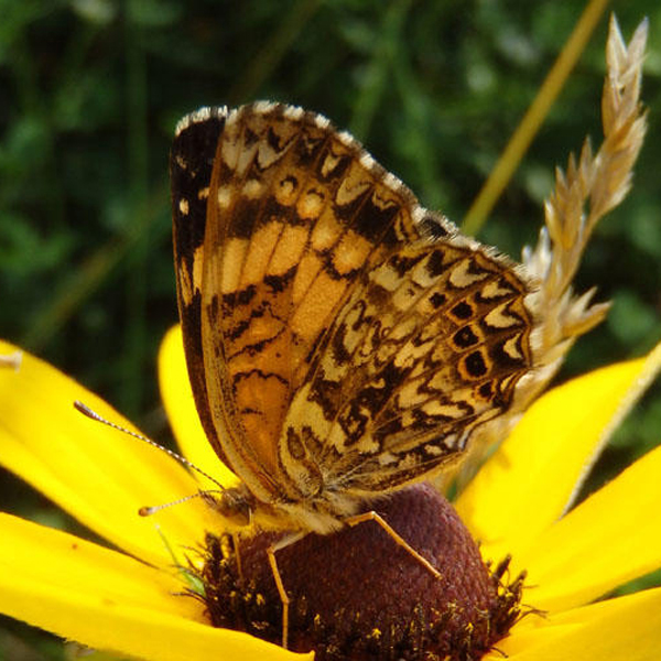
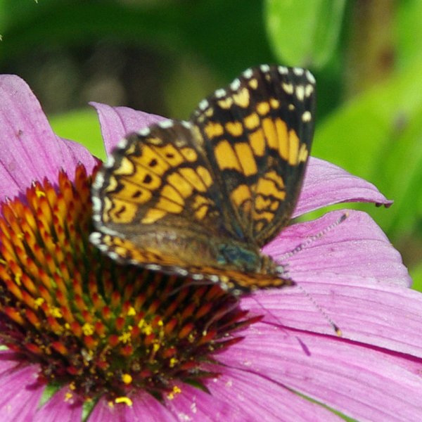
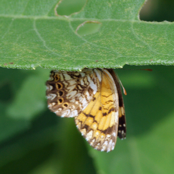
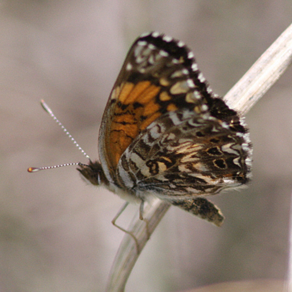
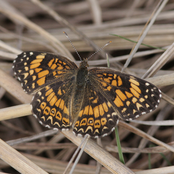
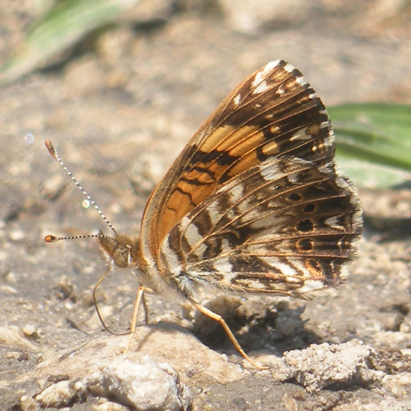
Distinguishing features: The upper wing surface is dark, with a dark band, an orange band with spots, and a tan band moving from the margin to the body. The hindwing below is highly figured with a central row of white arrowheads.
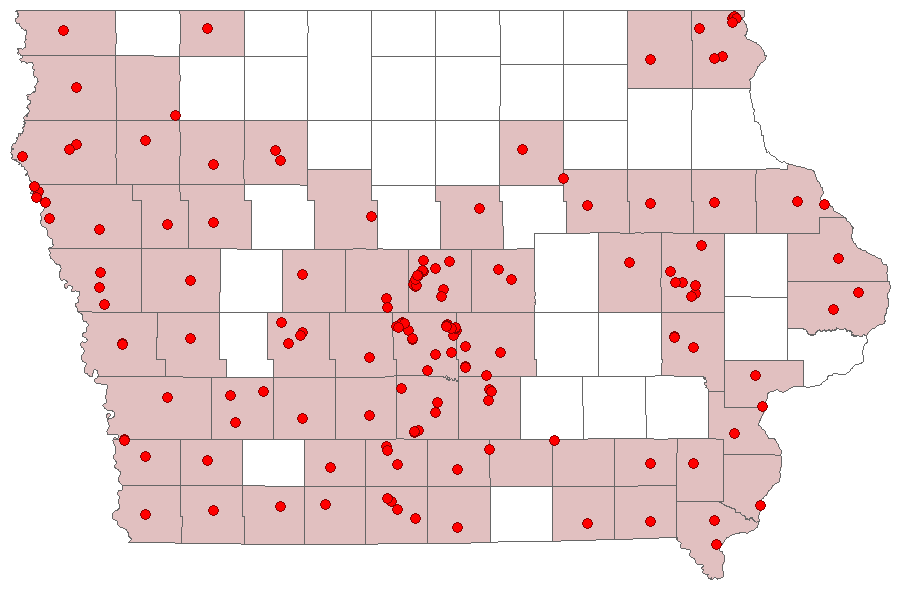
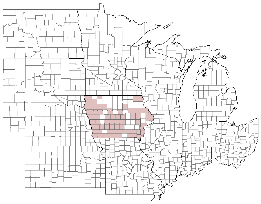
Distribution and habitat: Of regular occurrence throughout the southern three-fourths of the state, however its frequency appears higher towards the west, with populations becoming increasing uncommon towards the east. They occur in a wide variety of open habitats including old fields, roadsides, pastures, vacant lots, and native prairie.
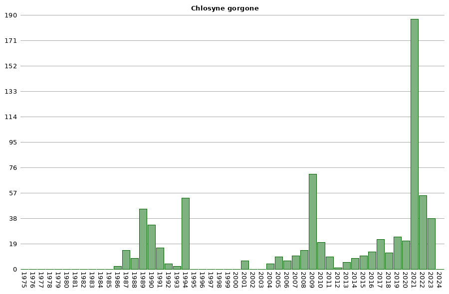
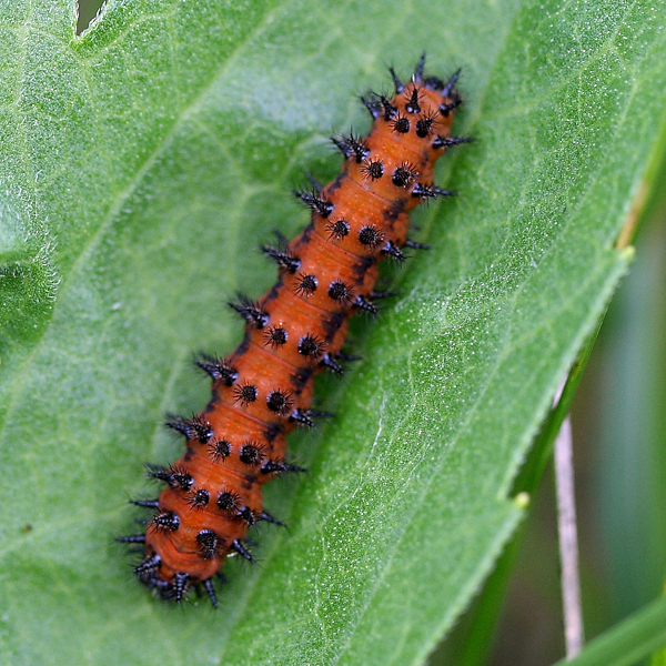
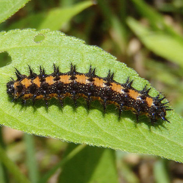
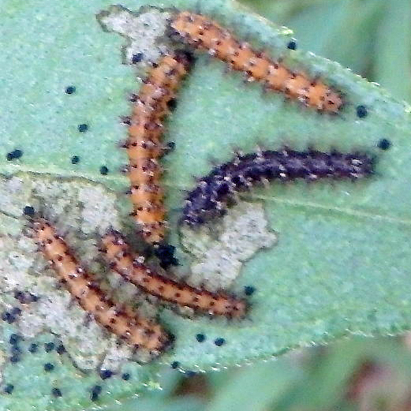
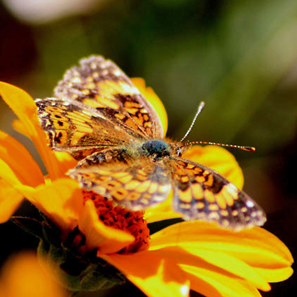
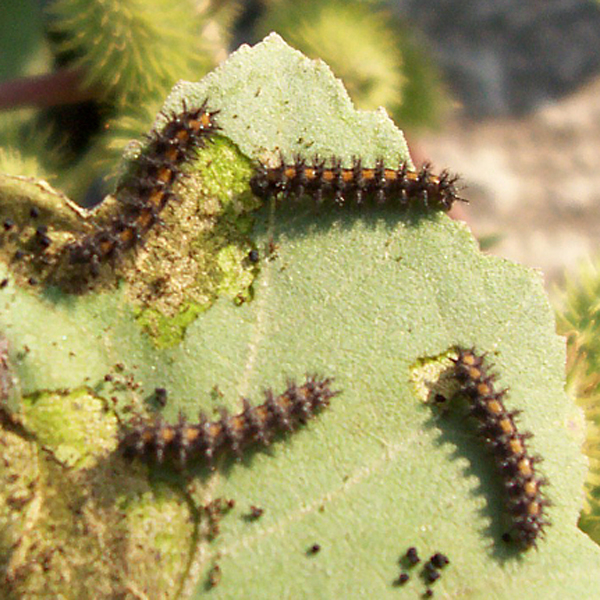
Natural History: Larvae consume carious members of the aster family, including sunflowers. It over-winters as half-grown larvae. Pupation lasts six days in the July brood. This very distinctive species may be expanding its range in Iowa as it did in Illinois (Irwin and Downey, 1973).


| Record # | Date | Locale | State | Lat/Lon | Collected By | Count |
|---|---|---|---|---|---|---|
| 346945 | 2023-08-05 | Folsom Point Preserve | Iowa | 41.154432 -95.799393 | Jay Gilliam | 2 |
 346356 346356
|
2023-07-30 | Loess Hills Scenic Overlook | Iowa | 41.905198 -95.945582 | Jay Gilliam | 4 |
 345078 345078
|
2023-07-29 | Jester Park | Iowa | 41.780904 -93.774207 | Mark Brown | 1 |
 342761 342761
|
2023-07-01 | Brushy Creek State Recreation Area | Iowa | 42.387084 -93.97563 | Mark Brown | 1 |
| 346454 | 2023-05-21 | Folsom Point Preserve | Iowa | 41.154432 -95.799393 | Jay Gilliam | 2 |
 346268 346268
|
2023-05-06 | Folsom Point Preserve | Iowa | 41.154432 -95.799393 | Jay Gilliam | 7 |
| 326451 | 2022-08-08 | Jester Park | Iowa | 41.786297 -93.788656 | IBSN | 1 |
| 318384 | 2022-08-07 | Cordova Park | Iowa | 41.42552 -93.089529 | Jay Gilliam | 1 |
 318292 318292
|
2022-07-31 | Folsom Point Preserve | Iowa | 41.154432 -95.799393 | Jay Gilliam | 1 |
| 326447 | 2022-07-31 | Doolittle Prairie State Preserve | Iowa | 42.148521 -93.589636 | IBSN | 1 |
| 326454 | 2022-07-28 | Swede Point Park | Iowa | 41.887058 -93.854351 | IBSN | 1 |
| 318282 | 2022-07-24 | Coyote Canyon Wildlife Area | Iowa | 41.099428 -93.858554 | Jay Gilliam | 1 |
| 326446 | 2022-07-17 | Doolittle Prairie State Preserve | Iowa | 42.148521 -93.589636 | IBSN | 1 |
| 326444 | 2022-07-14 | Chichaqua Bottoms Greenbelt | Iowa | 41.78688 -93.422013 | IBSN | 2 |
| 326443 | 2022-07-11 | Chichaqua Bottoms Greenbelt | Iowa | 41.78688 -93.422013 | IBSN | 5 |
| 326445 | 2022-07-10 | Doolittle Prairie State Preserve | Iowa | 42.148521 -93.589636 | IBSN | 1 |
| 326450 | 2022-07-09 | Jennett Heritage Area | Iowa | 41.950832 -93.456793 | IBSN | 1 |
| 326440 | 2022-07-03 | Ada Hayden Heritage Park | Iowa | 42.0638 -93.636305 | IBSN | 1 |
| 326439 | 2022-07-01 | Ada Hayden Heritage Park | Iowa | 42.0638 -93.636305 | IBSN | 4 |
| 326449 | 2022-07-01 | Jennett Heritage Area | Iowa | 41.950832 -93.456793 | IBSN | 12 |
| 326453 | 2022-07-01 | Swede Point Park | Iowa | 41.887058 -93.854351 | IBSN | 2 |
| 317962 | 2022-06-18 | Folsom Point Preserve | Iowa | 41.154432 -95.799393 | Jay Gilliam | 1 |
| 326442 | 2022-06-09 | Chichaqua Bottoms Greenbelt | Iowa | 41.78688 -93.422013 | IBSN | 1 |
| 326441 | 2022-06-06 | Chichaqua Bottoms Greenbelt | Iowa | 41.78688 -93.422013 | IBSN | 6 |
| 326438 | 2022-06-02 | Ada Hayden Heritage Park | Iowa | 42.0638 -93.636305 | IBSN | 1 |
 317778 317778
|
2022-05-27 | Folsom Point Preserve | Iowa | 41.154432 -95.799393 | Jay Gilliam | 3 |
| 326448 | 2022-05-16 | Jennett Heritage Area | Iowa | 41.950832 -93.456793 | IBSN | 7 |
| 326452 | 2022-05-16 | Swede Point Park | Iowa | 41.887058 -93.854351 | IBSN | 1 |
| 302961 | 2021-08-30 | F. W. Kent Park | Iowa | 41.726926 -91.737745 | IBSN | 1 |
| 302966 | 2021-08-29 | Moore Memorial Park | Iowa | 42.044476 -93.651247 | IBSN | 1 |
| 302970 | 2021-08-25 | F. W. Kent Park | Iowa | 41.726926 -91.737745 | IBSN | 1 |
| 302962 | 2021-08-16 | Moore Memorial Park | Iowa | 42.044476 -93.651247 | IBSN | 4 |
| 302967 | 2021-08-16 | Hertz Family Woods and Nature Preserve | Iowa | 41.989593 -93.441166 | IBSN | 4 |
| 302983 | 2021-08-09 | Moore Memorial Park | Iowa | 42.044476 -93.651247 | IBSN | 1 |
| 302980 | 2021-08-06 | Hertz Family Woods and Nature Preserve | Iowa | 41.989593 -93.441166 | IBSN | 4 |
| 302984 | 2021-08-06 | F. W. Kent Park | Iowa | 41.723806 -91.736417 | IBSN | 4 |
| 302981 | 2021-08-04 | Red Feather Prairie | Iowa | 41.7205866 -93.669776 | IBSN | 1 |
| 302960 | 2021-08-03 | Reiman Gardens Area, Ames | Iowa | 42.01102 -93.638089 | IBSN | 2 |
| 302974 | 2021-08-03 | Hertz Family Woods and Nature Preserve | Iowa | 41.989593 -93.441166 | IBSN | 9 |
| 302977 | 2021-08-02 | Chichaqua Bottoms Sandhill Prairie | Iowa | 41.77264 -93.384656 | IBSN | 2 |
| 302975 | 2021-07-26 | Hertz Family Woods and Nature Preserve | Iowa | 41.989593 -93.441166 | IBSN | 12 |
| 300796 | 2021-07-25 | Decatur Wildlife Management Area | Iowa | 40.831388 -93.856857 | Jay Gilliam | 1 |
| 302958 | 2021-07-08 | Chichaqua Bottoms Sandhill Prairie | Iowa | 41.77264 -93.384656 | IBSN | 37 |
| 302985 | 2021-07-05 | Moore Memorial Park | Iowa | 42.044476 -93.651247 | IBSN | 2 |
| 302972 | 2021-07-02 | Chichaqua Bottoms Sandhill Prairie | Iowa | 41.77264 -93.384656 | IBSN | 17 |
| 302973 | 2021-07-01 | Hertz Family Woods and Nature Preserve | Iowa | 41.989593 -93.441166 | IBSN | 4 |
| 302978 | 2021-07-01 | Red Feather Prairie | Iowa | 41.7205866 -93.669776 | IBSN | 2 |
| 302969 | 2021-06-30 | Reiman Gardens Area, Ames | Iowa | 42.01102 -93.638089 | IBSN | 1 |
 295581 295581
|
2021-06-27 | Rolling Thunder Prairie State Preserve | Iowa | 41.19979007 -93.65491484 | Mark Brown | 1 |
| 300604 | 2021-06-26 | Red Rock Reservoir- Hwy 14 & G28 | Iowa | 41.434442 -93.10052 | Jay Gilliam | 2 |
| 302959 | 2021-06-25 | Iowa Arboretum | Iowa | 41.937445 -93.861518 | IBSN | 2 |
| 302976 | 2021-06-23 | Red Feather Prairie | Iowa | 41.7205866 -93.669776 | IBSN | 16 |
| 302979 | 2021-06-23 | Chichaqua Bottoms Sandhill Prairie | Iowa | 41.77264 -93.384656 | IBSN | 27 |
| 302982 | 2021-06-22 | Moore Memorial Park | Iowa | 42.044476 -93.651247 | IBSN | 1 |
| 302963 | 2021-06-20 | Easter Lake | Iowa | 41.540666 -93.556688 | IBSN | 2 |
 300571 300571
|
2021-06-18 | Rolling Thunder Prairie State Preserve | Iowa | 41.204306 -93.656457 | Jay Gilliam | 1 |
| 302971 | 2021-06-10 | Chichaqua Bottoms Sandhill Prairie | Iowa | 41.77264 -93.384656 | IBSN | 3 |
| 302964 | 2021-05-30 | Chichaqua Bottoms Sandhill Prairie | Iowa | 41.77264 -93.384656 | IBSN | 1 |
| 300422 | 2021-05-29 | Folsom Point Preserve | Iowa | 41.154432 -95.799393 | Jay Gilliam | 1 |
 300408 300408
|
2021-05-22 | Folsom Point Preserve | Iowa | 41.154432 -95.799393 | Jay Gilliam | 1 |
| 302968 | 2021-05-19 | Hertz Family Woods and Nature Preserve | Iowa | 41.989593 -93.441166 | IBSN | 5 |
| 302965 | 2021-05-13 | Hertz Family Woods and Nature Preserve | Iowa | 41.989593 -93.441166 | IBSN | 10 |
| 302986 | 2021-05-05 | Hertz Family Woods and Nature Preserve | Iowa | 41.989593 -93.441166 | IBSN | 4 |
 275307 275307
|
2020-09-04 | Folsom Point Preserve | Iowa | 41.154432 -95.799393 | Jay Gilliam | 5 |
| 282913 | 2020-08-23 | Moore Memorial Park | Iowa | 42.044409 -93.651077 | IBSN | 1 |
| 282912 | 2020-08-13 | Reiman Gardens Area, Ames | Iowa | 42.010584 -93.638312 | IBSN | 1 |
| 282911 | 2020-08-11 | Mines of Spain State Recreational Area | Iowa | 42.453545 -90.63025 | IBSN | 1 |
| 276205 | 2020-08-08 | Eddyville Sand Prairie Park | Iowa | 41.154568 -92.618726 | Jay Gilliam | 1 |
| 282910 | 2020-08-03 | Max Daley Pathway | Iowa | 42.015183 -93.666138 | IBSN | 1 |
 276098 276098
|
2020-07-28 | Decatur Wildlife Management Area | Iowa | 40.831388 -93.856857 | Jay Gilliam | 1 |
 275951 275951
|
2020-07-10 | Coyote Canyon Wildlife Area | Iowa | 41.099428 -93.858554 | Jay Gilliam | 1 |
 275836 275836
|
2020-06-27 | Bundt Prairie | Iowa | 41.73245 -94.494439 | Jay Gilliam | 1 |
| 275851 | 2020-06-27 | Sheeder Prairie State Preserve | Iowa | 41.689477 -94.587704 | Jay Gilliam | 1 |
| 282909 | 2020-06-27 | Neal Smith National Wildlife Refuge | Iowa | 41.558756 -93.279723 | IBSN | 1 |
 275830 275830
|
2020-06-26 | Chichaqua Bottoms- Clingan Grassland Unit | Iowa | 41.777616 -93.355846 | Jay Gilliam | 1 |
 275754 275754
|
2020-06-23 | Decatur Wildlife Management Area | Iowa | 40.831388 -93.856857 | Jay Gilliam | 1 |
 275155 275155
|
2020-06-21 | Red Rock Reservoir- old bridge off Hwy14 & Illinois Ave-x | Iowa | 41.374208 -93.111246 | Jay Gilliam | 1 |
 275260 275260
|
2020-06-21 | Chichaqua Bottoms Greenbelt | Iowa | 41.788043 -93.417797 | Jay Gilliam | 3 |
| 250858 | 2019-08-09 | Big Creek State Park | Iowa | 41.802522 -93.733288 | IBSN | 9 |
| 250876 | 2019-08-04 | Thomas Mitchell Park | Iowa | 41.64 -93.3823 | IBSN | 4 |
| 250868 | 2019-07-22 | Emma McCarthy Lee Park | Iowa | 42.029276 -93.659334 | IBSN | 1 |
| 250874 | 2019-07-14 | Neal Smith National Wildlife Refuge | Iowa | 41.56153 -93.276552 | IBSN | 1 |
| 250867 | 2019-06-24 | Lake Anita State Park | Iowa | 41.423158 -94.772833 | IBSN | 6 |
| 250869 | 2019-06-03 | Mines of Spain State Recreational Area | Iowa | 42.450603 -90.629164 | IBSN | 1 |
| 240390 | 2019-05-31 | Cedar Hills Sand Prairie Preserve | Iowa | 42.59194 -92.55361 | Frank Olsen | 1 |
| 250866 | 2019-05-15 | Jennett Heritage Area | Iowa | 41.950832 -93.456793 | IBSN | 1 |
| 250865 | 2018-09-13 | Jennett Heritage Area | Iowa | 41.950832 -93.456793 | IBSN | 2 |
| 250857 | 2018-08-04 | Big Creek State Park | Iowa | 41.802522 -93.733288 | IBSN | 1 |
| 250864 | 2018-07-31 | Jennett Heritage Area | Iowa | 41.950832 -93.456793 | IBSN | 2 |
| 250877 | 2018-06-19 | Waterman Wildlife Addition | Iowa | 42.936357 -95.420094 | IBSN | 7 |
| 250863 | 2017-07-06 | Jennett Heritage Area | Iowa | 41.950832 -93.456793 | IBSN | 2 |
| 250873 | 2017-07-03 | Neal Smith National Wildlife Refuge | Iowa | 41.56153 -93.276552 | IBSN | 2 |
| 250872 | 2017-06-21 | Neal Smith National Wildlife Refuge | Iowa | 41.56153 -93.276552 | IBSN | 8 |
| 250862 | 2017-05-22 | Jennett Heritage Area | Iowa | 41.950832 -93.456793 | IBSN | 3 |
| 199311 | 2017-05-14 | Cedar Hills Sand Prairie Preserve | Iowa | 42.59194 -92.55361 | Frank Olsen | 6 |
 191286 191286
|
2017-05-14 | Stephens State Forest - Thousand Acre Unit, Lucas County | Iowa | 41.103003 -93.101751 | Mark Brown | 1 |
| 188540 | 2016-09-02 | Reiman Gardens Area, Ames | Iowa | 42.0118 -93.6382 | IBSN | 1 |
 181938 181938
|
2016-08-07 | Red Feather Prairie | Iowa | 41.715097 -93.6734342 | Mark Brown | 1 |
| 190626 | 2016-07-27 | Big Creek State Park | Iowa | 41.801614 -93.753022 | IBSN | 1 |
 181895 181895
|
2016-07-25 | Burlington | Iowa | 40.792831 -91.096827 | David Berry | 1 |
| 190782 | 2016-07-25 | Neal Smith National Wildlife Refuge | Iowa | 41.558683 -93.280422 | IBSN | 1 |
| 190273 | 2016-07-16 | Jennett Heritage Area | Iowa | 41.950832 -93.456793 | IBSN | 1 |
| 190263 | 2016-07-08 | Jennett Heritage Area | Iowa | 41.950832 -93.456793 | IBSN | 2 |
| 190259 | 2016-06-27 | Jennett Heritage Area | Iowa | 41.950832 -93.456793 | IBSN | 1 |
| 190765 | 2016-06-23 | Neal Smith National Wildlife Refuge | Iowa | 41.558683 -93.280422 | IBSN | 4 |
| 131353 | 2015-07-22 | Mile Long Prairie | Iowa | 43.40655 -91.550008 | Frank Olsen | 3 |
| 131338 | 2015-07-10 | Mile Long Prairie | Iowa | 43.40655 -91.550008 | Frank Olsen | 7 |
| 109650 | 2014-07-04 | Hartley Heritage Fen | Iowa | 41.762127 -93.347106 | Frank Olsen | 1 |
| 109721 | 2014-07-04 | Marietta Sand Prairie State Preserve | Iowa | 42.099164 -93.038965 | Frank Olsen | 1 |
| 109771 | 2014-07-04 | Puccoon Prairie | Iowa | 41.73528 -93.36417 | Frank Olsen | 1 |
 229315 229315
|
2014-07-04 | Ada Hayden Heritage Park | Iowa | 42.06694 -93.62944 | Wolfgang Oesterreich | 1 |
| 109879 | 2014-07-03 | Rolling Thunder Prairie State Preserve | Iowa | 41.2042 -93.656 | Frank Olsen | 1 |
 66084 66084
|
2014-06-28 | Big Creek State Park | Iowa | 41.807055 -93.745185 | Mark Brown | 1 |
 229288 229288
|
2014-06-23 | Ada Hayden Heritage Park | Iowa | 42.06694 -93.62944 | Wolfgang Oesterreich | 1 |
| 120363 | 2014-06-11 | Timberhill | Iowa | 40.715921 -93.651635 | Sibylla Brown | 1 |
| 6631 | 2013-08-10 | Chichaqua Bottoms Greenbelt | Iowa | 41.7958 -93.413 | Aaron Brees | 1 |
| 52236 | 2013-08-03 | Medora Prairie | Iowa | 41.209512 -93.627408 | Frank Olsen | 1 |
 144109 144109
|
2013-07-27 | Big Creek State Park | Iowa | 41.807055 -93.745185 | Mark Brown | 1 |
 138313 138313
|
2013-07-25 | Ackworth | Iowa | 41.36468 -93.48952 | John Pearson | 1 |
| 139839 | 2013-07-11 | Green Hills Retirement Community | Iowa | 42.001942 -93.647655 | IBSN | 1 |
 229255 229255
|
2012-06-11 | Ada Hayden Heritage Park | Iowa | 42.06694 -93.62944 | Wolfgang Oesterreich | 1 |
| 2360 | 2011-08-07 | Jasper County | Iowa | 41.6754922 -93.27767 | BAMONA | 1 |
 191770 191770
|
2011-08-02 | Swanson Prairie Production Plots | Iowa | 42.140352 -93.397827 | Jim Durbin | 1 |
 191774 191774
|
2011-08-02 | Swanson Prairie Production Plots | Iowa | 42.140352 -93.397827 | Jim Durbin | 1 |
 191776 191776
|
2011-08-02 | Swanson Prairie Production Plots | Iowa | 42.140352 -93.397827 | Jim Durbin | 1 |
 138266 138266
|
2011-07-29 | Engeldinger Marsh, Polk County | Iowa | 41.7761 -93.34941 | Betsy Betros | 1 |
 208750 208750
|
2011-05-22 | Folsom Point Preserve | Iowa | 41.16139 -95.795 | Aaron Brees | 4 |
| 6628 | 2010-09-04 | Folsom Point Preserve | Iowa | 41.153044 -95.796881 | Aaron Brees | 1 |
 138214 138214
|
2010-09-04 | Whiterock Conservancy | Iowa | 41.809175 -94.636271 | Leland Searles | 1 |
| 6625 | 2010-08-08 | Coyote Canyon | Iowa | 41.1213 -93.8614 | Aaron Brees | 2 |
| 6624 | 2010-08-07 | Manikowski Prairie State Preserve | Iowa | 41.972843 -90.375383 | Aaron Brees | 12 |
| 6630 | 2010-07-31 | Chichaqua Bottoms Greenbelt | Iowa | 41.7958 -93.413 | Aaron Brees | 1 |
| 141607 | 2010-06-30 | Reiman Gardens Area, Ames | Iowa | 42.01102 -93.638089 | IBSN | 2 |
 208751 208751
|
2010-05-15 | Chichaqua Bottoms Greenbelt | Iowa | 41.7958 -93.413 | Aaron Brees | 1 |
 208748 208748
|
2009-09-12 | Big Creek at Hwy 415 | Iowa | 41.76 -93.698 | Aaron Brees | 12 |
 208749 208749
|
2009-09-12 | Big Creek at Hwy 415 | Iowa | 41.76 -93.698 | Aaron Brees | 1 |
 208747 208747
|
2009-09-06 | Big Creek at Hwy 415 | Iowa | 41.76 -93.698 | Aaron Brees | 30 |
 108973 108973
|
2009-08-22 | Doolittle Prairie State Preserve | Iowa | 42.148521 -93.589636 | Tom Jantscher | 3 |
| 135244 | 2009-08-22 | Doolittle Prairie State Preserve | Iowa | 42.148521 -93.589636 | Tom Jantscher | 3 |
| 135016 | 2009-07-11 | Peterson Pits Recreation Area | Iowa | 42.085573 -93.591093 | Tom Jantscher | 1 |
| 135041 | 2009-07-11 | Peterson Pits Recreation Area | Iowa | 42.091225 -93.595474 | Tom Jantscher | 2 |
| 135077 | 2009-07-11 | Doolittle Prairie State Preserve | Iowa | 42.148521 -93.589636 | Tom Jantscher | 2 |
| 135103 | 2009-07-11 | Ada Hayden Heritage Park | Iowa | 42.06694 -93.62944 | Tom Jantscher | 2 |
| 52264 | 2009-07-07 | Sheeder Prairie State Preserve | Iowa | 41.689003 -94.587724 | Frank Olsen | 4 |
| 52262 | 2009-05-21 | Sheeder Prairie State Preserve | Iowa | 41.689003 -94.587724 | Frank Olsen | 11 |
| 52263 | 2008-08-11 | Sheeder Prairie State Preserve | Iowa | 41.689003 -94.587724 | Frank Olsen | 3 |
| 135074 | 2008-07-13 | Doolittle Prairie State Preserve | Iowa | 42.148521 -93.589636 | Tom Jantscher | 1 |
| 52219 | 2008-07-01 | Bundt Prairie | Iowa | 41.734068 -94.495878 | Frank Olsen | 2 |
| 52230 | 2008-05-24 | Manikowski Prairie State Preserve | Iowa | 41.972843 -90.375383 | Frank Olsen | 2 |
| 52232 | 2008-05-16 | Manikowski Prairie State Preserve | Iowa | 41.972843 -90.375383 | Frank Olsen | 5 |
 138480 138480
|
2008-05-14 | Little River Recreation Area | Iowa | 40.766842 -93.778789 | Aaron Brees | 1 |
| 52233 | 2007-08-10 | Manikowski Prairie State Preserve | Iowa | 41.972843 -90.375383 | Frank Olsen | 6 |
| 141270 | 2007-07-31 | Reiman Gardens Area, Ames | Iowa | 42.01102 -93.638089 | Nathan Brockman | 1 |
| 52234 | 2007-07-30 | Manikowski Prairie State Preserve | Iowa | 41.972843 -90.375383 | Frank Olsen | 1 |
| 134989 | 2007-07-29 | Ada Hayden Heritage Park | Iowa | 42.06694 -93.62944 | Tom Jantscher | 2 |
| 106853 | 2006-09-06 | Brush Creek Wetland | Iowa | 41.51367 -93.12767 | Frank Olsen | 1 |
| 52218 | 2006-08-27 | Blue Flag Marsh | Iowa | 41.441 -93.75533 | Frank Olsen | 1 |
| 106852 | 2006-05-26 | Brush Creek Wetland | Iowa | 41.51367 -93.12767 | Frank Olsen | 2 |
| 106851 | 2006-05-17 | Brush Creek Wetland | Iowa | 41.51367 -93.12767 | Frank Olsen | 2 |
| 52241 | 2005-08-18 | Rock Island Botanical State Preserve | Iowa | 42.02732 -91.72723 | Frank Olsen | 2 |
| 52240 | 2005-08-11 | Rock Island Botanical State Preserve | Iowa | 42.02732 -91.72723 | Frank Olsen | 2 |
| 52229 | 2005-07-27 | Manikowski Prairie State Preserve | Iowa | 41.972843 -90.375383 | Frank Olsen | 1 |
| 52274 | 2005-07-22 | Chichaqua Bottoms Sandhill Prairie | Iowa | 41.76717 -93.37483 | Frank Olsen | 2 |
| 52275 | 2005-06-30 | Chichaqua Bottoms Sandhill Prairie | Iowa | 41.76717 -93.37483 | Frank Olsen | 1 |
| 52273 | 2005-06-20 | Chichaqua Bottoms Sandhill Prairie | Iowa | 41.76717 -93.37483 | Frank Olsen | 1 |
| 52280 | 2004-08-04 | Wickiup Hill Outdoor Learning Area | Iowa | 42.08398 -91.7651 | Frank Olsen | 1 |
| 52231 | 2004-06-22 | Manikowski Prairie State Preserve | Iowa | 41.972843 -90.375383 | Frank Olsen | 3 |
| 113033 | 2001-06-30 | Heron Bend Conservation Area | Iowa | 40.572222 -91.424444 | Chris Edwards | 6 |
| 52224 | 1994-07-16 | Cedar Hills Sand Prairie Preserve | Iowa | 42.59305 -92.55315 | Ed Freese | 1 |
| 52225 | 1994-07-03 | Indian Creek Nature Center | Iowa | 41.9664 -91.5806 | Frank Olsen | 2 |
| 52223 | 1994-06-30 | Cedar Hills Sand Prairie Preserve | Iowa | 42.59305 -92.55315 | Ed Freese | 1 |
| 271927 | 1994-06-22 | Wayne County | Iowa | 40.668217 -93.338177 | Ron Harms | 18 |
| 271939 | 1994-06-22 | Lucas County | Iowa | 40.992037 -93.33865 | Ron Harms | 30 |
| 52222 | 1994-06-14 | Cedar Hills Sand Prairie Preserve | Iowa | 42.59305 -92.55315 | Ed Freese | 1 |
| 52221 | 1993-07-08 | Cedar Hills Sand Prairie Preserve | Iowa | 42.59305 -92.55315 | Ed Freese | 1 |
| 52220 | 1993-06-13 | Cedar Hills Sand Prairie Preserve | Iowa | 42.59305 -92.55315 | Ed Freese | 1 |
| 52238 | 1992-09-04 | Rock Island Botanical State Preserve | Iowa | 42.02732 -91.72723 | Frank Olsen | 1 |
| 52237 | 1992-08-20 | Millard Preserve | Iowa | 42.227954 -91.5335 | Frank Olsen | 1 |
 144443 144443
|
1992-08-20 | Millard Preserve | Iowa | 42.227871 -91.532398 | Frank Olsen | 2 |
| 52276 | 1991-08-30 | Wanatee County Park | Iowa | 42.00994 -91.57749 | Frank Olsen | 1 |
 144388 144388
|
1991-08-30 | Wanatee County Park | Iowa | 42.00994 -91.57749 | Frank Olsen | 1 |
| 52261 | 1991-08-04 | Rock Island Botanical State Preserve | Iowa | 42.02732 -91.72723 | Frank Olsen | 1 |
| 52244 | 1991-07-30 | Rock Island Botanical State Preserve | Iowa | 42.02732 -91.72723 | Frank Olsen | 2 |
| 52260 | 1991-07-21 | Rock Island Botanical State Preserve | Iowa | 42.02732 -91.72723 | Frank Olsen | 1 |
| 52253 | 1991-06-24 | Rock Island Botanical State Preserve | Iowa | 42.02732 -91.72723 | Frank Olsen | 9 |
| 52259 | 1991-06-15 | Rock Island Botanical State Preserve | Iowa | 42.02732 -91.72723 | Frank Olsen | 1 |
| 52213 | 1990-08-19 | Atlantic | Iowa | 41.404162 -95.012733 | Ron Harms | 1 |
| 52214 | 1990-08-19 | Atlantic | Iowa | 41.404162 -95.012733 | Ron Harms | 1 |
| 52216 | 1990-08-19 | Atlantic | Iowa | 41.404162 -95.012733 | Ron Harms | 1 |
| 52242 | 1990-08-18 | Rock Island Botanical State Preserve | Iowa | 42.02732 -91.72723 | Frank Olsen | 2 |
| 52243 | 1990-08-11 | Rock Island Botanical State Preserve | Iowa | 42.02732 -91.72723 | Frank Olsen | 2 |
| 52215 | 1990-08-05 | Atlantic | Iowa | 41.404162 -95.012733 | Ron Harms | 1 |
| 52217 | 1990-08-05 | Atlantic | Iowa | 41.404162 -95.012733 | Ron Harms | 1 |
| 52257 | 1990-07-14 | Rock Island Botanical State Preserve | Iowa | 42.02732 -91.72723 | Frank Olsen | 1 |
| 52246 | 1990-07-07 | Rock Island Botanical State Preserve | Iowa | 42.02732 -91.72723 | Frank Olsen | 3 |
| 347395 | 1990-07-04 | Rock Island Botanical State Preserve | Iowa | 42.02732 -91.72723 | Frank Olsen | 1 |
| 52239 | 1990-06-30 | Rock Island Botanical State Preserve | Iowa | 42.02732 -91.72723 | Frank Olsen | 2 |
| 52250 | 1990-05-18 | Rock Island Botanical State Preserve | Iowa | 42.02732 -91.72723 | Frank Olsen | 4 |
| 347378 | 1990-05-13 | Rock Island Botanical State Preserve | Iowa | 42.02732 -91.72723 | Frank Olsen | 4 |
| 52251 | 1990-05-11 | Rock Island Botanical State Preserve | Iowa | 42.02732 -91.72723 | Frank Olsen | 4 |
| 52252 | 1990-05-06 | Rock Island Botanical State Preserve | Iowa | 42.02732 -91.72723 | Frank Olsen | 4 |
| 52258 | 1990-04-30 | Rock Island Botanical State Preserve | Iowa | 42.02732 -91.72723 | Frank Olsen | 1 |
| 52256 | 1989-08-25 | Rock Island Botanical State Preserve | Iowa | 42.02732 -91.72723 | Frank Olsen | 1 |
| 124580 | 1989-08-25 | Rock Island Botanical State Preserve | Iowa | 42.02732 -91.72723 | Frank Olsen | 1 |
| 52255 | 1989-08-18 | Rock Island Botanical State Preserve | Iowa | 42.02732 -91.72723 | Frank Olsen | 1 |
| 124561 | 1989-08-18 | Rock Island Botanical State Preserve | Iowa | 42.02732 -91.72723 | Frank Olsen | 1 |
| 52235 | 1989-08-16 | Manikowski Prairie State Preserve | Iowa | 41.972843 -90.375383 | Tim Orwig | 1 |
| 124534 | 1989-08-11 | Rock Island Botanical State Preserve | Iowa | 42.02732 -91.72723 | Frank Olsen | 1 |
| 52249 | 1989-08-10 | Rock Island Botanical State Preserve | Iowa | 42.02732 -91.72723 | Frank Olsen | 1 |
| 124522 | 1989-08-10 | Rock Island Botanical State Preserve | Iowa | 42.02732 -91.72723 | Frank Olsen | 4 |
| 124510 | 1989-08-08 | Rock Island Botanical State Preserve | Iowa | 42.02732 -91.72723 | Frank Olsen | 4 |
| 124508 | 1989-08-06 | Sac and Fox Trail City Park | Iowa | 41.946803 -91.611754 | Frank Olsen | 1 |
| 52245 | 1989-08-05 | Rock Island Botanical State Preserve | Iowa | 42.02732 -91.72723 | Frank Olsen | 1 |
| 124494 | 1989-08-05 | Rock Island Botanical State Preserve | Iowa | 42.02732 -91.72723 | Frank Olsen | 3 |
| 106846 | 1989-08-04 | Pocahontas County | Iowa | 42.74456 -94.683864 | Ron Harms | 1 |
| 106847 | 1989-08-04 | Pocahontas County | Iowa | 42.74456 -94.683864 | Ron Harms | 1 |
| 124442 | 1989-07-04 | Sac and Fox Trail City Park | Iowa | 41.946803 -91.611754 | Frank Olsen | 1 |
| 52248 | 1989-07-01 | Rock Island Botanical State Preserve | Iowa | 42.02732 -91.72723 | Frank Olsen | 4 |
| 124421 | 1989-07-01 | Rock Island Botanical State Preserve | Iowa | 42.02732 -91.72723 | Frank Olsen | 4 |
| 52247 | 1989-06-24 | Rock Island Botanical State Preserve | Iowa | 42.02732 -91.72723 | Frank Olsen | 1 |
| 124383 | 1989-06-24 | Rock Island Botanical State Preserve | Iowa | 42.02732 -91.72723 | Frank Olsen | 4 |
 144267 144267
|
1989-06-24 | Rock Island Botanical State Preserve | Iowa | 42.026205 -91.726516 | Frank Olsen | 4 |
| 52279 | 1989-05-25 | War Eagle Park | Iowa | 42.49332 -96.4508 | Tim Orwig | 1 |
| 52228 | 1989-05-17 | Loess Hills Wildlife Management Area | Iowa | 42.08 -95.9765 | Tim Orwig | 1 |
| 52254 | 1989-05-10 | Rock Island Botanical State Preserve | Iowa | 42.02732 -91.72723 | Frank Olsen | 1 |
| 124280 | 1989-05-10 | Rock Island Botanical State Preserve | Iowa | 42.02732 -91.72723 | Frank Olsen | 1 |
 144251 144251
|
1989-05-10 | Rock Island Botanical State Preserve | Iowa | 42.026205 -91.726516 | Frank Olsen | 1 |
| 52271 | 1988-08-17 | Sioux City State Prairie Preserve | Iowa | 42.5241 -96.4362 | Tim Orwig | 1 |
| 106843 | 1988-07-01 | Harrison County | Iowa | 41.68714 -95.810212 | Tim Orwig | 1 |
| 52277 | 1988-06-21 | Stone State Park | Iowa | 42.55333 -96.46194 | Tim Orwig | 1 |
| 52278 | 1988-05-27 | Broken Kettle Grasslands Preserve | Iowa | 42.71583 -96.55333 | Tim Orwig | 1 |
| 52270 | 1988-05-19 | Sioux City State Prairie Preserve | Iowa | 42.5241 -96.4362 | Tim Orwig | 1 |
| 106845 | 1988-05-17 | Sergeant Floyd Monument | Iowa | 42.462464 -96.377962 | Tim Orwig | 1 |
| 52269 | 1988-05-10 | Sioux City State Prairie Preserve | Iowa | 42.5241 -96.4362 | Tim Orwig | 1 |
| 52272 | 1988-05-09 | Sioux City State Prairie Preserve | Iowa | 42.5241 -96.4362 | Tim Orwig | 1 |
| 52268 | 1987-09-13 | Sioux City State Prairie Preserve | Iowa | 42.5241 -96.4362 | Tim Orwig | 1 |
| 52212 | 1987-07-01 | Allamakee County | Iowa | 43.2544 -91.38097 | J. Nehuevaj | 1 |
| 52226 | 1987-06-29 | Black Hawk Point Wildlife Management Area | Iowa | 43.45604 -91.30837 | J. Nehuevaj | 1 |
| 358509 | 1987-06-29 | Allamakee Sand Cove | Iowa | 43.436325 -91.30626 | John G. Nehnevaj | 1 |
| 52227 | 1987-06-24 | Black Hawk Point Wildlife Management Area | Iowa | 43.46996 -91.29466 | J. Nehuevaj | 1 |
| 355120 | 1987-06-24 | Fish Farm Mounds-x | Iowa | 43.457445 -91.276393 | John G. Nehnevaj | 1 |
| 355121 | 1987-06-24 | Fish Farm Mounds-x | Iowa | 43.457445 -91.276393 | John G. Nehnevaj | 1 |
| 355122 | 1987-06-24 | Fish Farm Mounds-x | Iowa | 43.457445 -91.276393 | John G. Nehnevaj | 1 |
| 106842 | 1987-06-19 | Big Sand Mound Prairie Preserve, Muscatine County | Iowa | 41.341015 -91.086545 | Dennis Schlicht | 1 |
| 52267 | 1987-05-09 | Sioux City State Prairie Preserve | Iowa | 42.5241 -96.4362 | Tim Orwig | 1 |
| 106841 | 1987-05-09 | Big Sand Mound Prairie Preserve, Muscatine County | Iowa | 41.341015 -91.086545 | Dennis Schlicht | 1 |
| 352037 | 1987-01-01 | Allamakee County | Iowa | 43.243076 -91.443466 | John G. Nehnevaj | 1 |
| 352036 | 1987-01-01 | Allamakee County | Iowa | 43.243076 -91.443466 | John G. Nehnevaj | 1 |
| 352035 | 1987-01-01 | Allamakee County | Iowa | 43.243076 -91.443466 | John G. Nehnevaj | 1 |
| 52266 | 1986-08-13 | Sioux City State Prairie Preserve | Iowa | 42.5241 -96.4362 | Tim Orwig | 1 |
| 52265 | 1986-07-11 | Sioux City State Prairie Preserve | Iowa | 42.5241 -96.4362 | Tim Orwig | 1 |
| 2333 | 1950-07-01 | Adair County | Iowa | 41.274178 -94.479983 | USGS - NPWRC | 1 |
| 2334 | 1950-07-01 | Allamakee County | Iowa | 43.243076 -91.443466 | USGS - NPWRC | 1 |
| 2335 | 1950-07-01 | Benton County | Iowa | 42.138725 -92.066521 | USGS - NPWRC | 1 |
| 2336 | 1950-07-01 | Black Hawk County | Iowa | 42.447803 -92.381363 | USGS - NPWRC | 1 |
| 2337 | 1950-07-01 | Buchanan County | Iowa | 42.4566 -91.909927 | USGS - NPWRC | 1 |
| 2338 | 1950-07-01 | Buena Vista County | Iowa | 42.670544 -95.143204 | USGS - NPWRC | 1 |
| 2339 | 1950-07-01 | Buena Vista County | Iowa | 42.750217 -92.857712 | USGS - NPWRC | 1 |
| 2340 | 1950-07-01 | Cass County | Iowa | 41.253807 -94.976654 | USGS - NPWRC | 1 |
| 2341 | 1950-07-01 | Cherokee County | Iowa | 42.802776 -95.645798 | USGS - NPWRC | 1 |
| 2342 | 1950-07-01 | Clarke County | Iowa | 41.017784 -93.784149 | USGS - NPWRC | 1 |
| 2343 | 1950-07-01 | Clinton County | Iowa | 41.878563 -90.563606 | USGS - NPWRC | 1 |
| 2344 | 1950-07-01 | Crawford County | Iowa | 42.034687 -95.310249 | USGS - NPWRC | 1 |
| 2345 | 1950-07-01 | Dallas County | Iowa | 41.612003 -93.987846 | USGS - NPWRC | 1 |
| 2346 | 1950-07-01 | Davis County | Iowa | 40.691383 -92.381363 | USGS - NPWRC | 1 |
| 2347 | 1950-07-01 | Decatur County | Iowa | 40.814648 -93.824821 | USGS - NPWRC | 1 |
| 2348 | 1950-07-01 | Delaware County | Iowa | 42.463402 -91.443466 | USGS - NPWRC | 1 |
| 2349 | 1950-07-01 | Dickinson County | Iowa | 43.404938 -95.184921 | USGS - NPWRC | 1 |
| 2350 | 1950-07-01 | Dubuque County | Iowa | 42.469467 -90.829399 | USGS - NPWRC | 1 |
| 2351 | 1950-07-01 | Sidney | Iowa | 40.74004 -95.645798 | USGS - NPWRC | 1 |
| 2352 | 1950-07-01 | Greene County | Iowa | 42.070053 -94.479973 | USGS - NPWRC | 1 |
| 2353 | 1950-07-01 | Guthrie County | Iowa | 41.75309 -94.479973 | USGS - NPWRC | 1 |
| 2354 | 1950-07-01 | Hardin County | Iowa | 42.428543 -93.177963 | USGS - NPWRC | 1 |
| 2355 | 1950-07-01 | Harrison County | Iowa | 41.693386 -95.814285 | USGS - NPWRC | 1 |
| 2356 | 1950-07-01 | Henry County | Iowa | 41.028358 -91.598396 | USGS - NPWRC | 1 |
| 2357 | 1950-07-01 | Ida Grove | Iowa | 42.341869 -95.477783 | USGS - NPWRC | 1 |
| 2358 | 1950-07-01 | Jackson County | Iowa | 42.156071 -90.52578 | USGS - NPWRC | 1 |
| 2359 | 1950-07-01 | Jasper County | Iowa | 41.641491 -93.01757 | USGS - NPWRC | 1 |
| 2361 | 1950-07-01 | Jefferson County | Iowa | 41.023636 -91.909927 | USGS - NPWRC | 1 |
| 2362 | 1950-07-01 | Johnson County | Iowa | 41.669899 -91.598396 | USGS - NPWRC | 1 |
| 2363 | 1950-07-01 | Lee County | Iowa | 40.706867 -91.443466 | USGS - NPWRC | 1 |
| 2364 | 1950-07-01 | Linn County | Iowa | 42.027289 -91.67275 | USGS - NPWRC | 1 |
| 2365 | 1950-07-01 | Louisa County | Iowa | 41.193298 -91.289101 | USGS - NPWRC | 1 |
| 2366 | 1950-07-01 | Lyon County | Iowa | 43.3936 -96.2479 | USGS - NPWRC | 1 |
| 2367 | 1950-07-01 | Madison County | Iowa | 41.292236 -93.987846 | USGS - NPWRC | 1 |
| 2368 | 1950-07-01 | Marshall County | Iowa | 42.04071 -92.937576 | USGS - NPWRC | 1 |
| 2369 | 1950-07-01 | Mills County | Iowa | 41.06245 -95.645798 | USGS - NPWRC | 1 |
| 2370 | 1950-07-01 | Monona County | Iowa | 42.001595 -95.983261 | USGS - NPWRC | 1 |
| 2371 | 1950-07-01 | Anderson Conservation Area | Iowa | 41.043884 -95.184921 | USGS - NPWRC | 1 |
| 2372 | 1950-07-01 | Muscatine County | Iowa | 41.51569 -91.1353 | USGS - NPWRC | 1 |
| 2373 | 1950-07-01 | Page County | Iowa | 40.763512 -95.143204 | USGS - NPWRC | 1 |
| 2374 | 1950-07-01 | Plymouth County | Iowa | 42.776665 -96.152695 | USGS - NPWRC | 1 |
| 2375 | 1950-07-01 | Pocahontas County | Iowa | 42.691803 -94.645035 | USGS - NPWRC | 1 |
| 2376 | 1950-07-01 | Polk County | Iowa | 41.627842 -93.500343 | USGS - NPWRC | 1 |
| 2377 | 1950-07-01 | Pottawattamie County | Iowa | 41.391151 -95.477783 | USGS - NPWRC | 1 |
| 2378 | 1950-07-01 | Ringgold County | Iowa | 40.797382 -94.315422 | USGS - NPWRC | 1 |
| 2379 | 1950-07-01 | Sac County | Iowa | 42.357353 -95.143204 | USGS - NPWRC | 1 |
| 2380 | 1950-07-01 | Shelby County | Iowa | 41.717766 -95.310249 | USGS - NPWRC | 1 |
| 2381 | 1950-07-01 | Sioux County | Iowa | 43.086994 -96.152695 | USGS - NPWRC | 1 |
| 2382 | 1950-07-01 | Story County | Iowa | 42.104046 -93.500343 | USGS - NPWRC | 1 |
| 2383 | 1950-07-01 | Taylor County | Iowa | 40.784607 -94.645035 | USGS - NPWRC | 1 |
| 2384 | 1950-07-01 | Union County | Iowa | 41.000687 -94.274361 | USGS - NPWRC | 1 |
| 2385 | 1950-07-01 | Van Buren County | Iowa | 40.700115 -91.909927 | USGS - NPWRC | 1 |
| 2386 | 1950-07-01 | Warren County | Iowa | 41.308056 -93.500343 | USGS - NPWRC | 1 |
| 2387 | 1950-07-01 | Winneshiek County | Iowa | 43.236259 -91.909927 | USGS - NPWRC | 1 |
| 2388 | 1950-07-01 | Woodbury County | Iowa | 42.316616 -95.983261 | USGS - NPWRC | 1 |
| 106849 | 1936-07-21 | Dickinson County, Iowa | Iowa | Location Protected | 1 | |
| 106850 | 1936-07-07 | Lyon County | Iowa | 43.3936 -96.2479 | 1 | |
| 106848 | 1935-08-14 | Plymouth County | Iowa | 42.752959 -96.206675 | 1 | |
| 106844 | 1930-05-16 | Port Neal Rest Stop | Iowa | 42.373941 -96.35428 | Tim Orwig | 1 |