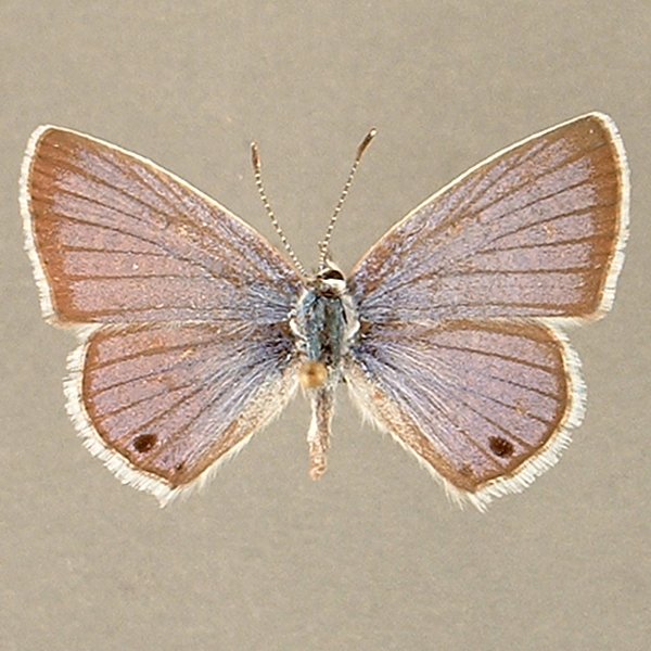
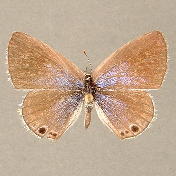
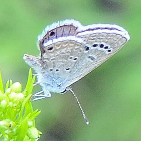
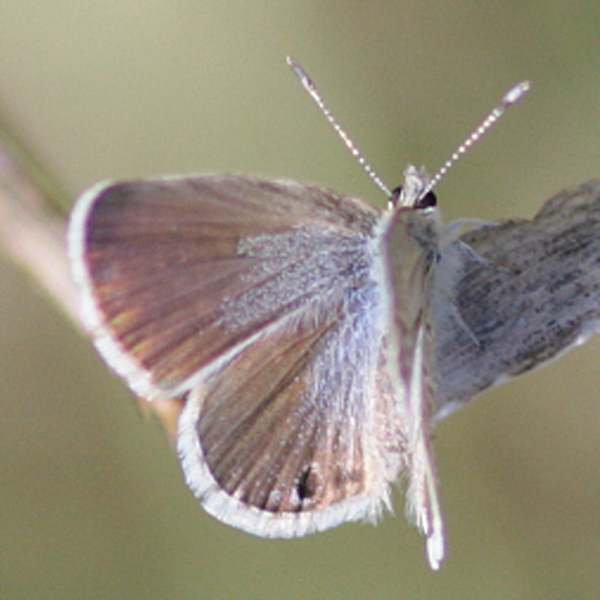
Wing span: 2.1-2.5 cm.
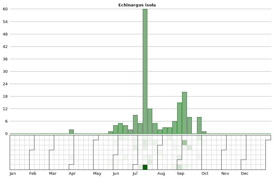
Flight time: Multiple broods; the first from late-May to early-June; the second from late-June through July; the last from mid-August to early-September. A rare partial fourth brood may appear from late-September to frost.
Status: Breeding resident.
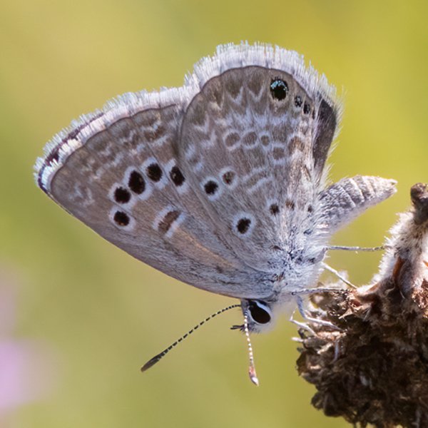
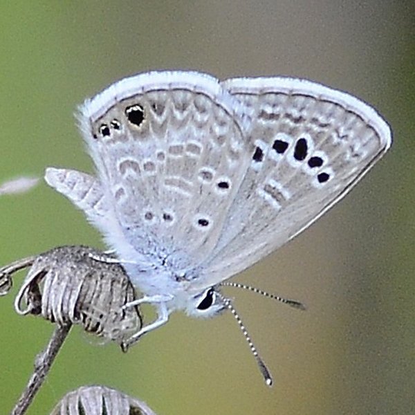
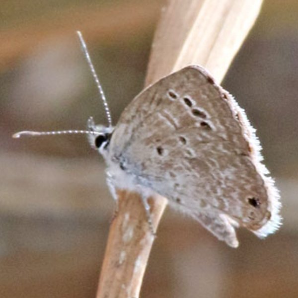
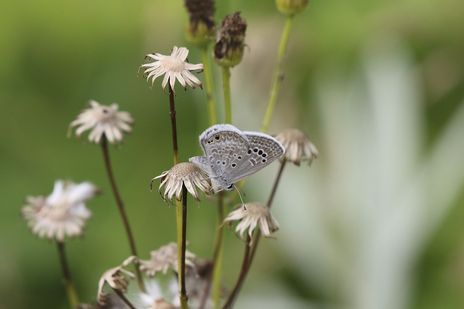
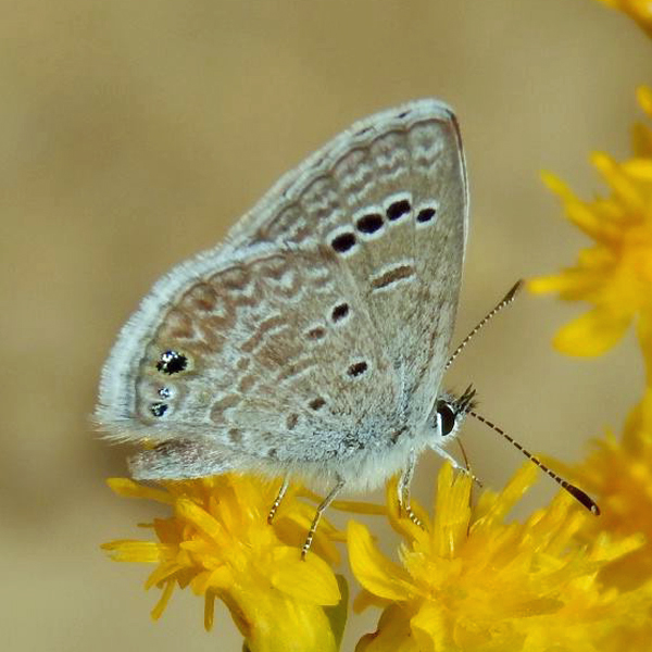
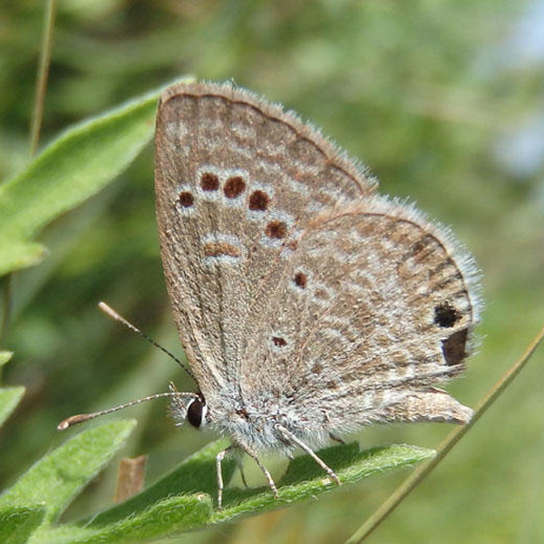
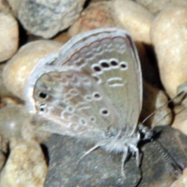
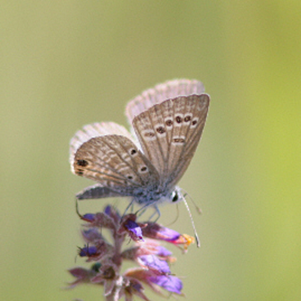
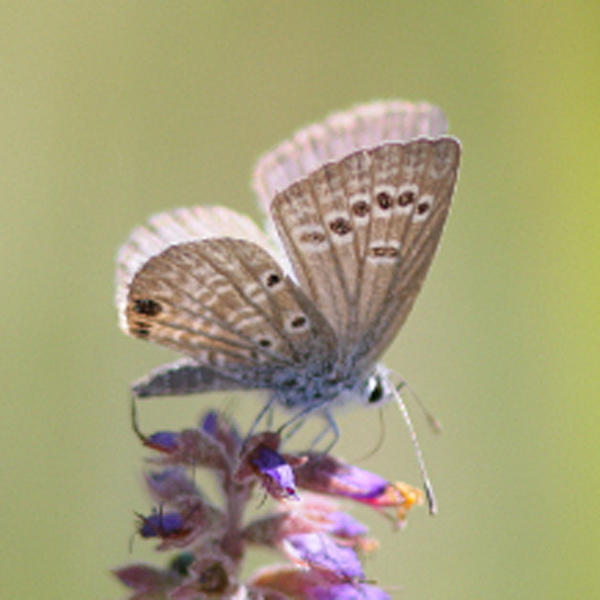
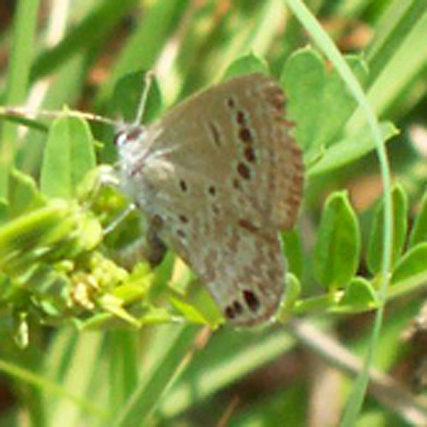
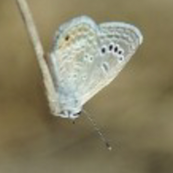
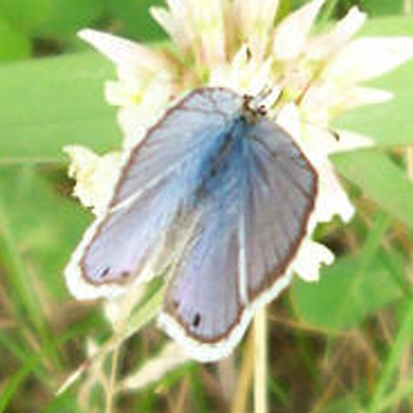
Distinguishing features: The sexes differ with the males being blue above and the female’s slate-gray above with blue limited to a basal area on the dorsal surface. There are usually two black spots at the anal angle of both sides of the hindwing. The forewings below have a narrow submarginal band of small rectangles and prominent postmedial row of white-circled black spots. The hindwings below also have three or four black spots in the basal area.
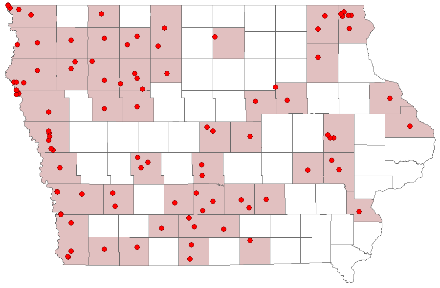
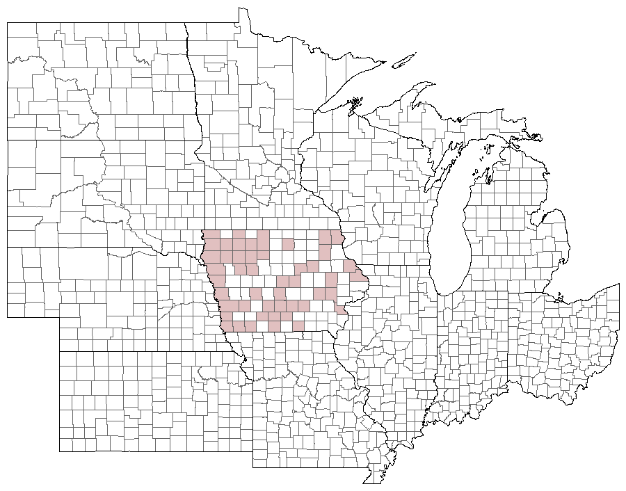
Distribution and habitat: Scattered, but frequent in the western half; scattered and uncommon to rare in the east. Across Iowa, populations appear essentially limited to native prairies.
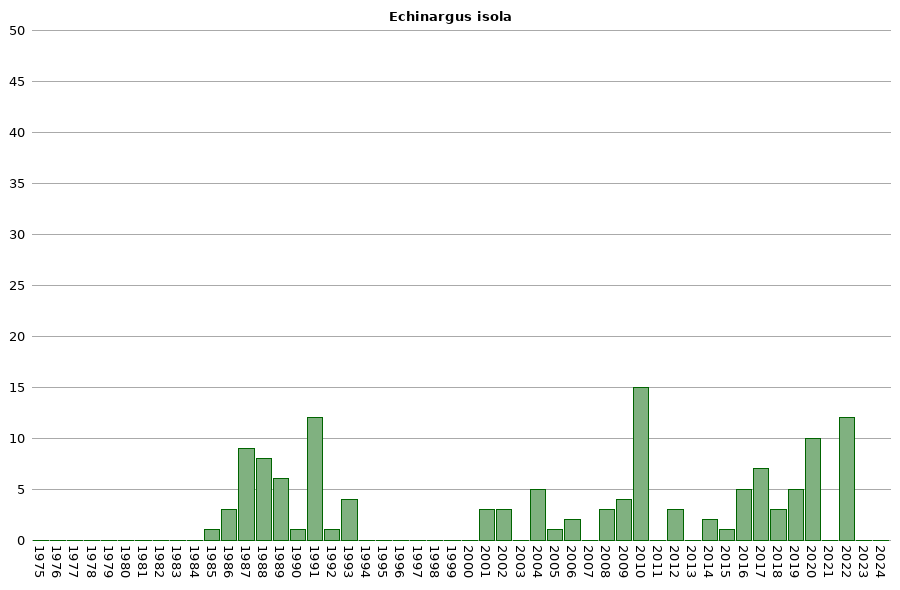
Natural History: Larvae consume a wide assortment of legumes. Iowa populations seem to often occur in prairies with large amounts of leadplant; perhaps this species serves are a preferred host in the state. Even though considered by most authorities (e.g. Opler & Malikul 1992) to not overwinter in Iowa, our observations suggest that this is not always true. First, it is essentially limited to native prairie; if it were a migrant, it should be found across a wide variety of habitats. Second, at a given site, many fresh adults mark their initial emergence in spring; this also seems unlikely for an emigrating species, when a few worn adults should mark its initial occurrence. Last, populations have proven to be persistent on given sites over multiple years.


| Record # | Date | Locale | State | Lat/Lon | Collected By | Count |
|---|---|---|---|---|---|---|
 318655 318655
|
2022-09-24 | Loess Hills Scenic Overlook | Iowa | 41.905198 -95.945582 | Jay Gilliam | 2 |
 319665 319665
|
2022-09-24 | Loess Hills Scenic Overlook | Iowa | 41.905198 -95.945582 | Jay Gilliam | 2 |
 318506 318506
|
2022-09-02 | Loess Hills Scenic Overlook | Iowa | 41.905198 -95.945582 | Jay Gilliam | 4 |
 319664 319664
|
2022-09-02 | Loess Hills Scenic Overlook | Iowa | 41.905198 -95.945582 | Jay Gilliam | 4 |
| 281116 | 2020-08-30 | Waubonsie State Park | Iowa | 40.677029 -95.691183 | Chris Edwards | 1 |
| 273427 | 2020-08-21 | Hitchcock Nature Center | Iowa | 41.416 -95.8495 | Frank Olsen | 2 |
| 284161 | 2020-08-01 | Churchville Prairie | Iowa | 41.40306 -93.751671 | IBSN | 2 |
| 284160 | 2020-07-19 | Churchville Prairie | Iowa | 41.40306 -93.751671 | IBSN | 2 |
 284159 284159
|
2020-07-09 | Chain Lakes County Park | Iowa | 42.057726 -91.763904 | IBSN | 1 |
| 284158 | 2020-06-23 | Churchville Prairie | Iowa | 41.40306 -93.751671 | IBSN | 1 |
| 281115 | 2020-06-06 | Hawkeye Willdlife Management Area | Iowa | 41.775104 -91.705532 | Chris Edwards | 1 |
| 275548 | 2019-09-16 | Slip Bluff County Park | Iowa | 40.652884 -93.847544 | Jay Gilliam | 1 |
 275529 275529
|
2019-09-05 | Wilcox Wildlife Area | Iowa | 41.238081 -92.956863 | Jay Gilliam | 1 |
| 254433 | 2019-08-29 | Churchville Prairie | Iowa | 41.405565 -93.751417 | IBSN | 1 |
| 275522 | 2019-08-27 | Pammel State Park | Iowa | 41.294986 -94.074903 | Jay Gilliam | 1 |
 238818 238818
|
2019-06-27 | Cedar Hills Sand Prairie Preserve | Iowa | 42.594715 -92.553111 | Tom Schilke | 1 |
| 224099 | 2018-09-12 | Loess Hills Scenic Overlook | Iowa | 41.904962 -95.945821 | Frank Olsen | 2 |
| 224125 | 2018-09-12 | Hitchcock Nature Center | Iowa | 41.41733 -95.85388 | Frank Olsen | 1 |
 201923 201923
|
2017-09-12 | Waubonsie State Park | Iowa | 40.676 -95.689 | Jacob Newton | 1 |
| 254436 | 2017-07-24 | Red Feather Prairie | Iowa | 41.723743 -93.671574 | IBSN | 2 |
| 254435 | 2017-07-14 | Red Feather Prairie | Iowa | 41.723743 -93.671574 | IBSN | 1 |
| 193867 | 2017-07-09 | Rolling Thunder Prairie State Preserve | Iowa | 41.2042 -93.656 | Mark Brown | 1 |
 202565 202565
|
2017-07-09 | Rolling Thunder Prairie State Preserve | Iowa | 41.2042 -93.656 | Mark Brown | 1 |
| 254434 | 2017-06-27 | Red Feather Prairie | Iowa | 41.723743 -93.671574 | IBSN | 1 |
| 181156 | 2016-09-27 | Rock Island Botanical State Preserve | Iowa | 42.0263889 -91.7269444 | Frank Olsen | 1 |
| 180743 | 2016-08-30 | Loess Hills Scenic Overlook | Iowa | 41.904962 -95.945821 | Frank Olsen | 2 |
 200615 200615
|
2016-08-09 | Des Moines-x | Iowa | 41.601432 -93.663846 | Barb Manning | 1 |
| 182063 | 2016-07-24 | Decatur County, Iowa | Iowa | Location Protected | Sibylla Brown | 1 |
| 136228 | 2015-07-24 | Decatur County, Iowa | Iowa | Location Protected | Sibylla Brown | 1 |
| 6762 | 2014-06-25 | Sylvan Runkel State Preserve | Iowa | 42.105 -95.98233 | Aaron Brees | 1 |
| 67763 | 2014-06-25 | Sylvan Runkel State Preserve | Iowa | 42.105 -95.98233 | Aaron Brees | 1 |
| 6760 | 2012-09-08 | Preparation Canyon State Park | Iowa | 41.89133 -95.91407 | Aaron Brees | 1 |
| 8296 | 2012-09-08 | Preparation Canyon State Park | Iowa | 41.89133 -95.91407 | Tom Jantscher | 1 |
 24439 24439
|
2012-06-08 | Whiterock Conservancy | Iowa | 41.80725 -94.64085 | Leland Searles | 1 |
 138212 138212
|
2010-09-04 | Folsom Point Preserve | Iowa | 41.162167 -95.796896 | Aaron Brees | 13 |
 208693 208693
|
2010-09-04 | Folsom Point Preserve | Iowa | 41.159184 -95.797691 | Aaron Brees | 1 |
 208692 208692
|
2010-09-04 | Folsom Point Preserve | Iowa | 41.161653 -95.797612 | Aaron Brees | 1 |
 208694 208694
|
2009-06-18 | Turin Loess Hills State Preserve | Iowa | 42.0455 -95.965 | Aaron Brees | 1 |
| 247995 | 2009-06-04 | Gitchie Manitou State Preserve | Iowa | 43.49666 -96.59563 | Frank Olsen | 1 |
 227655 227655
|
2009-03-30 | Bentsen-Rio Grande Valley State Park | Texas | 26.185599 -98.379533 | Jim Durbin | 1 |
 227656 227656
|
2009-03-30 | Bentsen-Rio Grande Valley State Park | Texas | 26.185599 -98.379533 | Jim Durbin | 1 |
| 54639 | 2008-08-23 | Stinson Prairie State Preserve | Iowa | 43.046817 -94.325983 | Frank Olsen | 1 |
| 54632 | 2008-08-11 | Sheeder Prairie State Preserve | Iowa | 41.689003 -94.587724 | Frank Olsen | 1 |
 208691 208691
|
2008-07-10 | Coyote Canyon | Iowa | 41.1213 -93.8614 | Aaron Brees | 1 |
| 54626 | 2006-09-12 | Hitchcock Nature Center | Iowa | 41.41733 -95.85388 | Frank Olsen | 1 |
| 54617 | 2006-08-07 | Doolittle Prairie State Preserve | Iowa | 42.148521 -93.589636 | Frank Olsen | 1 |
| 54625 | 2005-09-12 | Hitchcock Nature Center | Iowa | 41.41733 -95.85388 | Frank Olsen | 1 |
| 106956 | 2004-07-10 | Steele Prairie State Preserve West | Iowa | 42.876238 -95.58001 | Jerry Selby | 3 |
| 54623 | 2004-07-09 | Glacial Hills Preserve, Nature Conservancy | Iowa | 42.88367 -95.32233 | Frank Olsen | 1 |
| 54619 | 2004-07-07 | Gitchie Manitou State Preserve | Iowa | 43.4997 -96.5983 | Frank Olsen | 1 |
| 271905 | 2002-09-28 | Rock Island Botanical State Preserve | Iowa | 42.02732 -91.72723 | Dennis Schlicht | 1 |
| 54616 | 2002-08-13 | Five Ridge Prairie State Preserve | Iowa | 42.6496 -96.5032 | Dennis Schlicht | 2 |
| 54627 | 2001-09-11 | Honey Creek State Park | Iowa | 40.86526 -92.94011 | Frank Olsen | 1 |
| 248313 | 2001-07-26 | Seed Saver Exchange | Iowa | 43.385026 -91.808464 | Frank Olsen | 1 |
| 144582 | 2001-06-29 | Seed Saver Exchange | Iowa | 43.384234 -91.809094 | Frank Olsen | 1 |
| 54628 | 1993-07-21 | Kalsow Prairie State Preserve | Iowa | 42.5734 -94.5677 | Mike Saunders | 1 |
| 54615 | 1993-07-16 | Bokelmann Prairie | Iowa | 43.15267 -93.47017 | Mike Saunders | 1 |
| 54611 | 1993-06-26 | Blood Run Preserve | Iowa | 43.468461 -96.568663 | Mike Saunders | 1 |
| 54612 | 1993-06-26 | Blood Run Preserve | Iowa | 43.468461 -96.568663 | Mike Saunders | 1 |
| 54631 | 1992-09-04 | Rock Island Botanical State Preserve | Iowa | 42.02732 -91.72723 | Frank Olsen | 1 |
| 54609 | 1991-07-21 | Atlantic | Iowa | 41.404162 -95.012733 | Ron Harms | 1 |
| 54610 | 1991-07-21 | Atlantic | Iowa | 41.404162 -95.012733 | Ron Harms | 1 |
| 54638 | 1991-07-20 | Sioux City State Prairie Preserve | Iowa | 42.5241 -96.4362 | Tim Orwig | 1 |
| 106952 | 1991-07-13 | Pocahontas County | Iowa | 42.74456 -94.683864 | Ron Harms | 1 |
| 106954 | 1991-07-13 | Pocahontas County | Iowa | 42.74456 -94.683864 | Ron Harms | 1 |
| 106963 | 1991-06-15 | Sunken Grove State Game Management Area | Iowa | 42.63 -94.896134 | Ron Harms | 1 |
| 106964 | 1991-06-15 | Sunken Grove State Game Management Area | Iowa | 42.63 -94.896134 | Ron Harms | 1 |
| 54620 | 1991-06-03 | Gitchie Manitou State Preserve | Iowa | 43.4997 -96.5983 | Tim Orwig | 1 |
| 54621 | 1991-06-02 | Gitchie Manitou State Preserve | Iowa | 43.4997 -96.5983 | Tim Orwig | 1 |
| 54646 | 1991-05-29 | Telford Prairie | Iowa | 43.065 -94.7914 | Ron Harms | 1 |
| 54647 | 1991-05-29 | Telford Prairie | Iowa | 43.065 -94.7914 | Ron Harms | 1 |
| 106950 | 1991-05-26 | Riverside Bluff | Iowa | 42.512005 -96.470623 | Tim Orwig | 1 |
| 106951 | 1990-09-04 | Mount Talbot State Preserve | Iowa | 42.563828 -96.469054 | Tim Orwig | 1 |
 29726 29726
|
1989-09-01 | Tim Orwig Specimen No data-x | Iowa | 42.64444 -96.35806 | Tim Orwig | 1 |
| 106957 | 1989-08-26 | Oak Grove State Park | Iowa | 43.064284 -96.458383 | Tim Orwig | 1 |
| 106958 | 1989-08-26 | Oak Grove State Park | Iowa | 43.064284 -96.458383 | Tim Orwig | 1 |
| 106953 | 1989-07-21 | Pocahontas County | Iowa | 42.74456 -94.683864 | Ron Harms | 1 |
| 106955 | 1989-07-21 | Pocahontas County | Iowa | 42.74456 -94.683864 | Ron Harms | 1 |
| 54629 | 1989-06-04 | Loess Hills Wildlife Management Area | Iowa | 42.08 -95.9765 | Ron Harms | 1 |
| 106962 | 1988-10-01 | Huser's Prairie | Iowa | 42.650399 -96.468816 | Tim Orwig | 1 |
| 106961 | 1988-09-24 | Huser's Prairie | Iowa | 42.650399 -96.468816 | Tim Orwig | 1 |
| 54645 | 1988-08-20 | Stone State Park | Iowa | 42.55383 -96.4665 | Tim Orwig | 1 |
| 54644 | 1988-07-15 | Stone State Park | Iowa | 42.55383 -96.4665 | Tim Orwig | 1 |
| 54643 | 1988-07-14 | Stone State Park | Iowa | 42.55383 -96.4665 | Tim Orwig | 1 |
| 106960 | 1988-07-08 | Huser's Prairie | Iowa | 42.650399 -96.468816 | Tim Orwig | 1 |
| 54640 | 1988-06-26 | Stone State Park | Iowa | 42.55333 -96.46194 | Tim Orwig | 1 |
| 54642 | 1988-06-26 | Stone State Park | Iowa | 42.55383 -96.4665 | Tim Orwig | 1 |
| 54618 | 1987-07-10 | French Creek Wildlife Management Area | Iowa | 43.39075 -91.412 | J. Nehuevaj | 1 |
| 358846 | 1987-07-10 | Sunflower Drive Hill Prairie | Iowa | 43.387 -91.456 | John G. Nehnevaj | 1 |
| 358847 | 1987-07-10 | Sunflower Drive Hill Prairie | Iowa | 43.387 -91.456 | John G. Nehnevaj | 1 |
| 54624 | 1987-07-08 | Hanover Township | Iowa | 43.37643 -91.54023 | J. Nehuevaj | 1 |
| 358463 | 1987-07-08 | Riverside Drive | Iowa | 43.427167 -91.52 | John G. Nehnevaj | 1 |
| 358579 | 1987-07-08 | Mile Long Prairie | Iowa | 43.4065 -91.563833 | John G. Nehnevaj | 1 |
| 54622 | 1987-06-11 | Gitchie Manitou State Preserve | Iowa | 43.4997 -96.5983 | Tim Orwig | 1 |
| 106959 | 1987-06-11 | Larchwood | Iowa | 43.452312 -96.431715 | Tim Orwig | 1 |
| 54637 | 1987-06-04 | Sioux City State Prairie Preserve | Iowa | 42.5241 -96.4362 | Tim Orwig | 1 |
| 54636 | 1986-09-27 | Sioux City State Prairie Preserve | Iowa | 42.5241 -96.4362 | Tim Orwig | 1 |
| 54635 | 1986-07-17 | Sioux City State Prairie Preserve | Iowa | 42.5241 -96.4362 | Tim Orwig | 1 |
| 54634 | 1986-07-05 | Sioux City State Prairie Preserve | Iowa | 42.5241 -96.4362 | Tim Orwig | 1 |
| 54633 | 1985-08-13 | Sioux City State Prairie Preserve | Iowa | 42.5241 -96.4362 | Tim Orwig | 1 |
| 2789 | 1950-07-15 | Allamakee County | Iowa | 43.243076 -91.443466 | USGS - NPWRC | 1 |
| 2790 | 1950-07-15 | Black Hawk County | Iowa | 42.447803 -92.381363 | USGS - NPWRC | 1 |
| 2791 | 1950-07-15 | Buena Vista County | Iowa | 42.670544 -95.143204 | USGS - NPWRC | 1 |
| 2792 | 1950-07-15 | Calhoun County | Iowa | 42.37859 -94.645035 | USGS - NPWRC | 1 |
| 2793 | 1950-07-15 | Cass County | Iowa | 41.253807 -94.976654 | USGS - NPWRC | 1 |
| 2794 | 1950-07-15 | Cherokee County | Iowa | 42.802776 -95.645798 | USGS - NPWRC | 1 |
| 2795 | 1950-07-15 | Clarke County | Iowa | 41.017784 -93.784149 | USGS - NPWRC | 1 |
| 2796 | 1950-07-15 | Clay County | Iowa | 43.136803 -95.143204 | USGS - NPWRC | 1 |
| 2797 | 1950-07-15 | Decatur County | Iowa | 40.814648 -93.824821 | USGS - NPWRC | 1 |
| 2798 | 1950-07-15 | Dickinson County | Iowa | 43.404938 -95.184921 | USGS - NPWRC | 1 |
| 2799 | 1950-07-15 | Dubuque County | Iowa | 42.469467 -90.829399 | USGS - NPWRC | 1 |
| 2800 | 1950-07-15 | Fayette County | Iowa | 42.925819 -91.909927 | USGS - NPWRC | 1 |
| 2801 | 1950-07-15 | Sidney | Iowa | 40.74004 -95.645798 | USGS - NPWRC | 1 |
| 2802 | 1950-07-15 | Grundy County | Iowa | 42.436951 -92.857712 | USGS - NPWRC | 1 |
| 2803 | 1950-07-15 | Guthrie County | Iowa | 41.75309 -94.479973 | USGS - NPWRC | 1 |
| 2804 | 1950-07-15 | Harrison County | Iowa | 41.693386 -95.814285 | USGS - NPWRC | 1 |
| 2805 | 1950-07-15 | Humboldt County | Iowa | 42.74826 -94.192337 | USGS - NPWRC | 1 |
| 2806 | 1950-07-15 | Iowa County | Iowa | 41.66246 -92.066521 | USGS - NPWRC | 1 |
| 2807 | 1950-07-15 | Jackson County | Iowa | 42.156071 -90.52578 | USGS - NPWRC | 1 |
| 2808 | 1950-07-15 | Johnson County | Iowa | 41.669899 -91.598396 | USGS - NPWRC | 1 |
| 2809 | 1950-07-15 | Kossuth County | Iowa | 43.251339 -94.233337 | USGS - NPWRC | 1 |
| 2810 | 1950-07-15 | Linn County | Iowa | 42.027289 -91.67275 | USGS - NPWRC | 1 |
| 2811 | 1950-07-15 | Louisa County | Iowa | 41.193298 -91.289101 | USGS - NPWRC | 1 |
| 2812 | 1950-07-15 | Lucas County | Iowa | 40.991203 -93.33889 | USGS - NPWRC | 1 |
| 2813 | 1950-07-15 | Lyon County | Iowa | 43.3936 -96.2479 | USGS - NPWRC | 1 |
| 2814 | 1950-07-15 | Mahaska County | Iowa | 41.32959 -92.698387 | USGS - NPWRC | 1 |
| 2815 | 1950-07-15 | Marshall County | Iowa | 42.04071 -92.937576 | USGS - NPWRC | 1 |
| 2816 | 1950-07-15 | Mills County | Iowa | 41.06245 -95.645798 | USGS - NPWRC | 1 |
| 2817 | 1950-07-15 | Monona County | Iowa | 42.001595 -95.983261 | USGS - NPWRC | 1 |
| 2818 | 1950-07-15 | O'Brien County | Iowa | 43.113125 -95.645798 | USGS - NPWRC | 1 |
| 2819 | 1950-07-15 | Page County | Iowa | 40.763512 -95.143204 | USGS - NPWRC | 1 |
| 2820 | 1950-07-15 | Palo Alto County | Iowa | 43.158089 -94.645035 | USGS - NPWRC | 1 |
| 2821 | 1950-07-15 | Plymouth County | Iowa | 42.776665 -96.152695 | USGS - NPWRC | 1 |
| 2822 | 1950-07-15 | Pocahontas County | Iowa | 42.691803 -94.645035 | USGS - NPWRC | 1 |
| 2823 | 1950-07-15 | Pottawattamie County | Iowa | 41.391151 -95.477783 | USGS - NPWRC | 1 |
| 2824 | 1950-07-15 | Sac County | Iowa | 42.357353 -95.143204 | USGS - NPWRC | 1 |
| 2825 | 1950-07-15 | Sioux County | Iowa | 43.086994 -96.152695 | USGS - NPWRC | 1 |
| 2826 | 1950-07-15 | Story County | Iowa | 42.104046 -93.500343 | USGS - NPWRC | 1 |
| 2827 | 1950-07-15 | Taylor County | Iowa | 40.784607 -94.645035 | USGS - NPWRC | 1 |
| 2828 | 1950-07-15 | Union County | Iowa | 41.000687 -94.274361 | USGS - NPWRC | 1 |
| 2829 | 1950-07-15 | Warren County | Iowa | 41.308056 -93.500343 | USGS - NPWRC | 1 |
| 2830 | 1950-07-15 | Winneshiek County | Iowa | 43.236259 -91.909927 | USGS - NPWRC | 1 |
| 2831 | 1950-07-15 | Woodbury County | Iowa | 42.316616 -95.983261 | USGS - NPWRC | 1 |
| 54630 | 1950-07-15 | O'Brien County | Iowa | 43.1131 -95.6458 | Tim Orwig | 1 |
| 106949 | 1939-07-17 | Marion County | Iowa | 41.325547 -93.069235 | 1 | |
| 54641 | 1930-08-31 | Stone State Park | Iowa | 42.55333 -96.46194 | Tim Orwig | 1 |