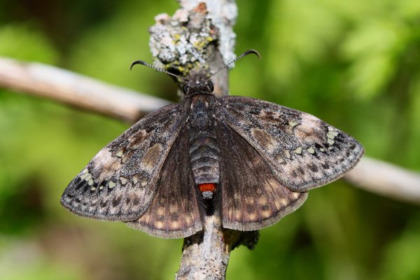
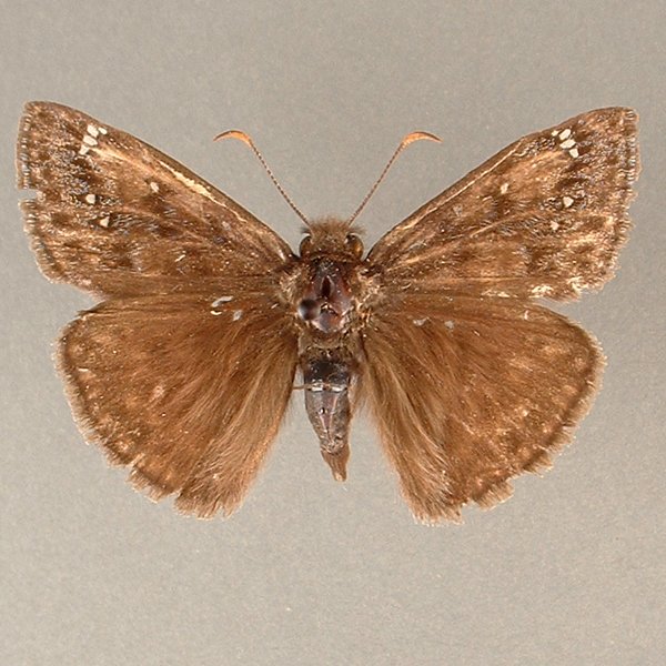
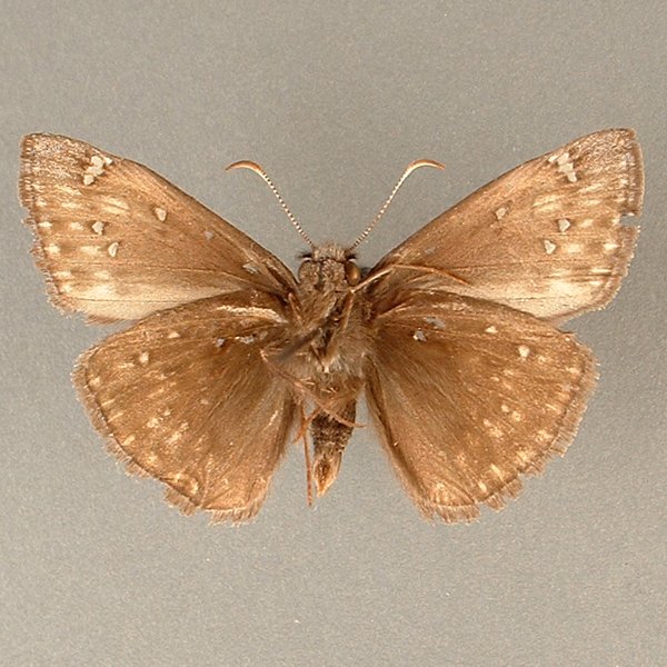
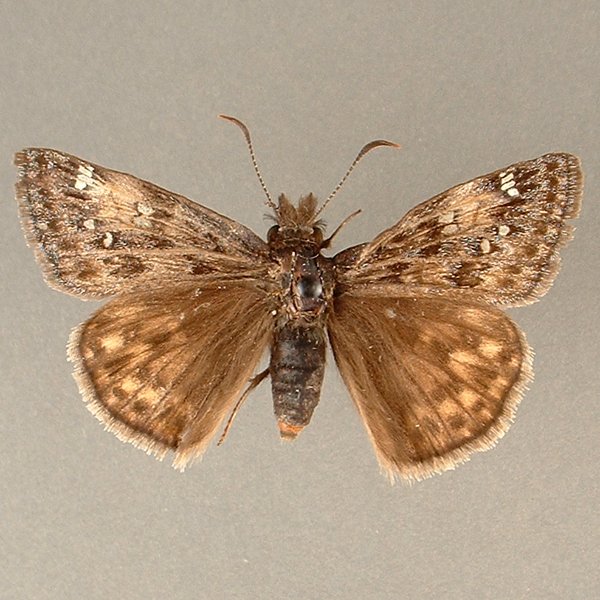
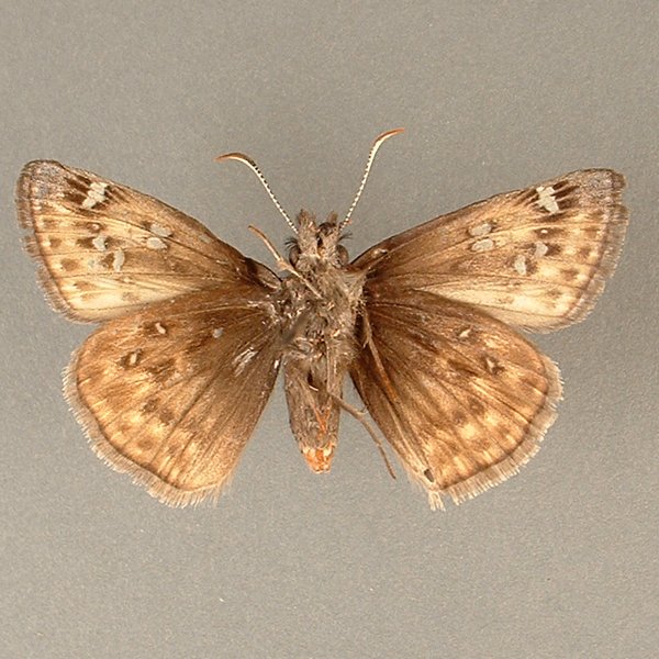
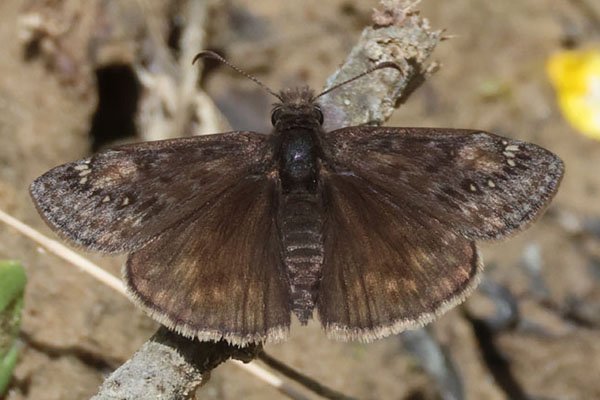
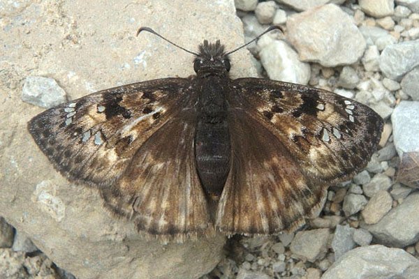
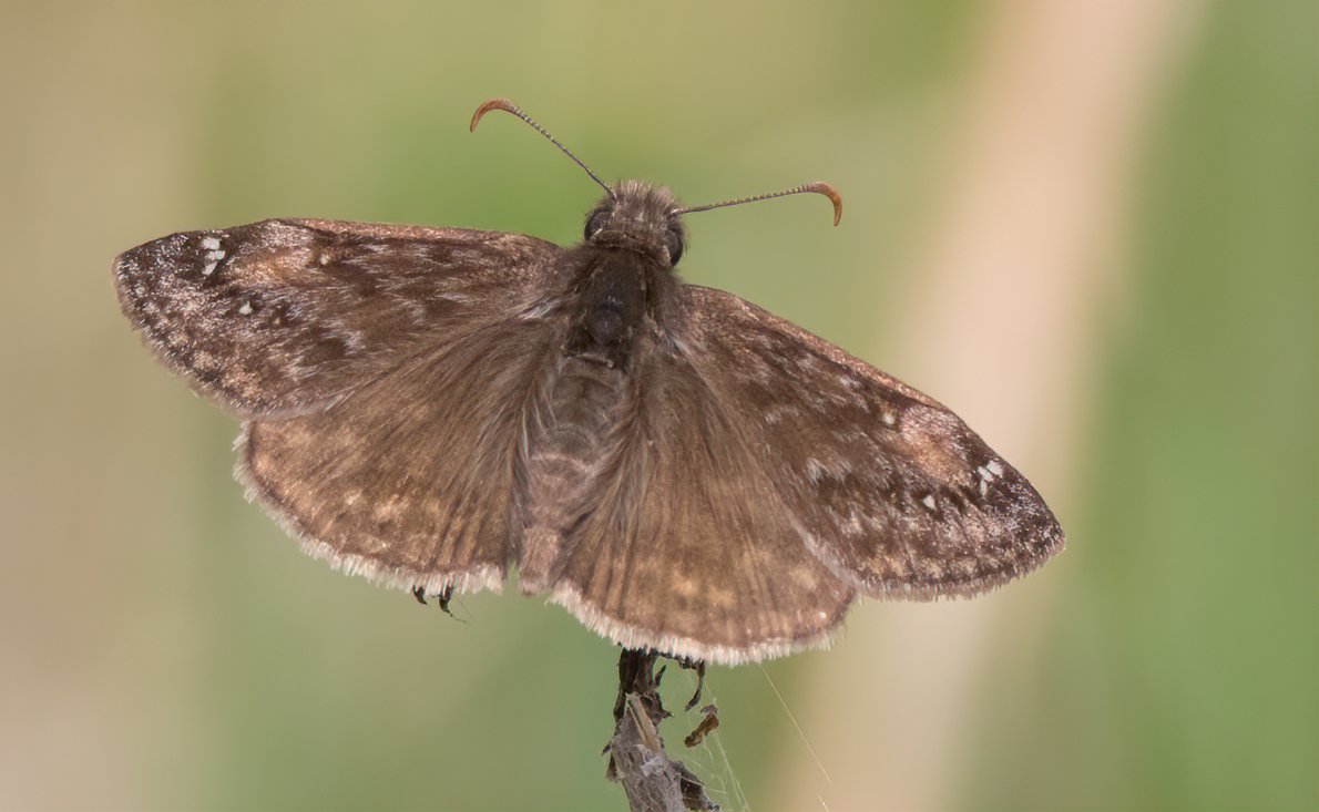
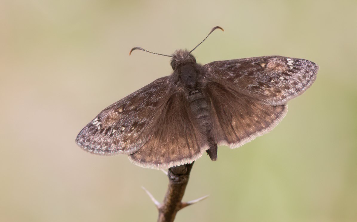
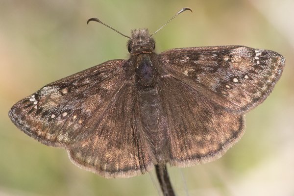
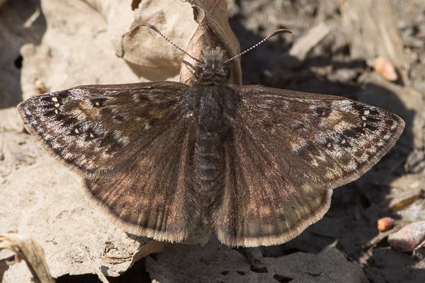
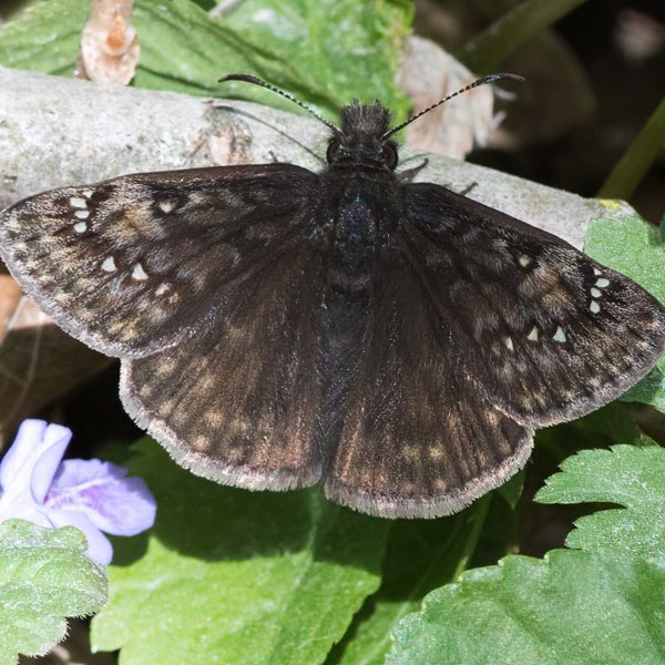
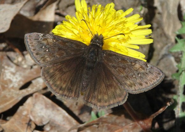
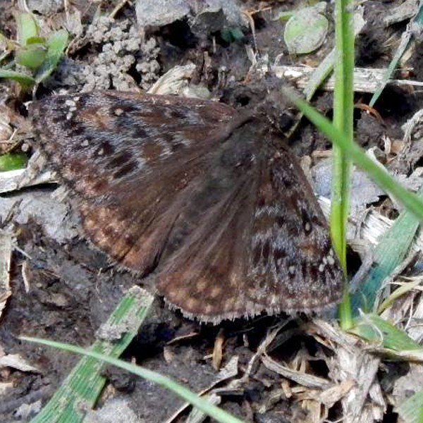
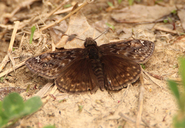
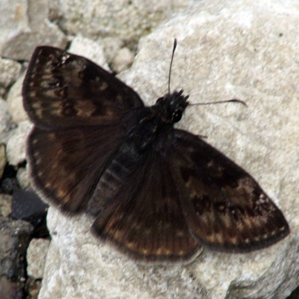
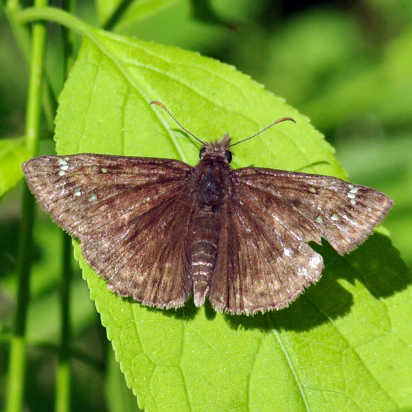
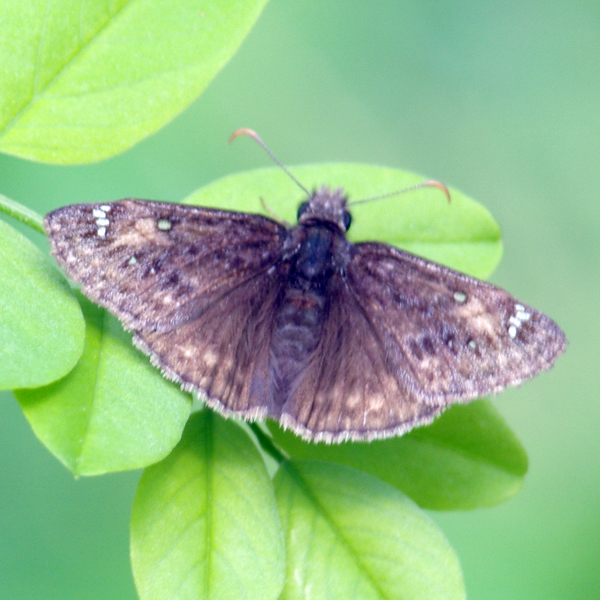
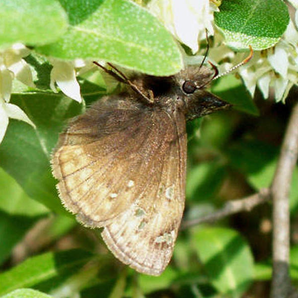
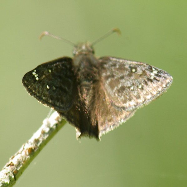
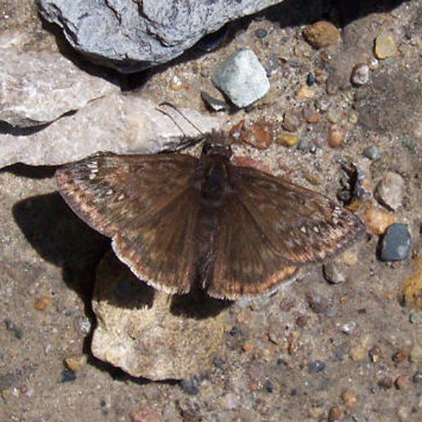
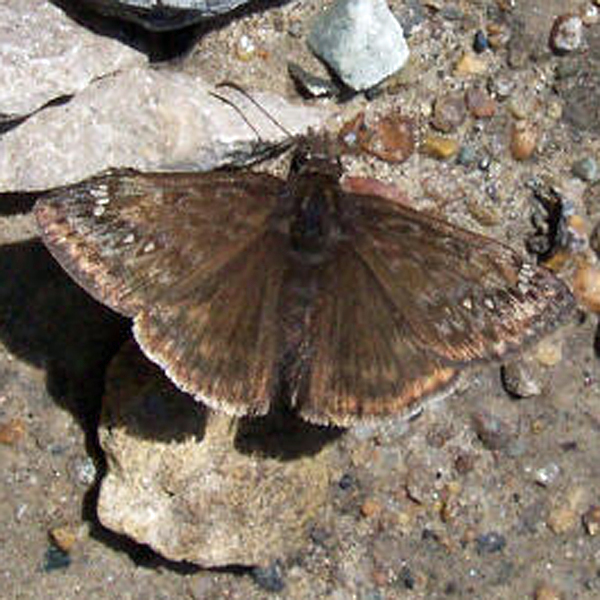
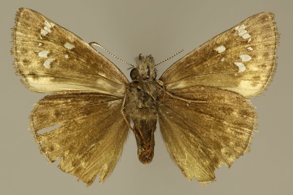
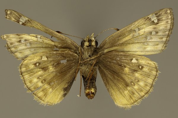
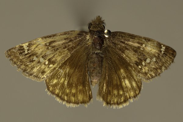
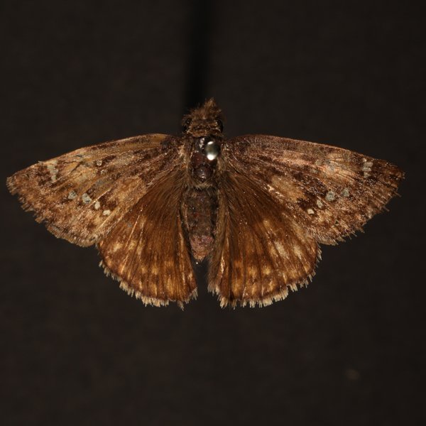
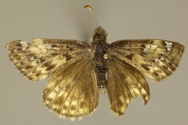
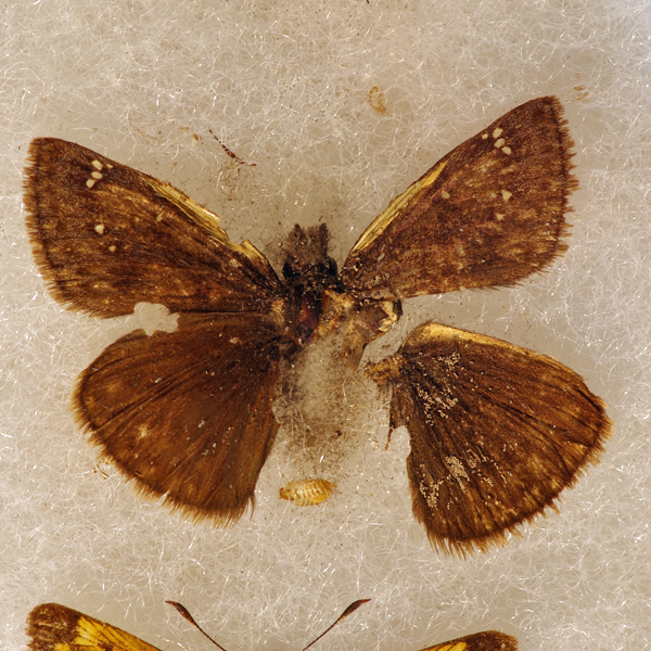
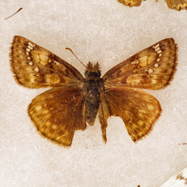
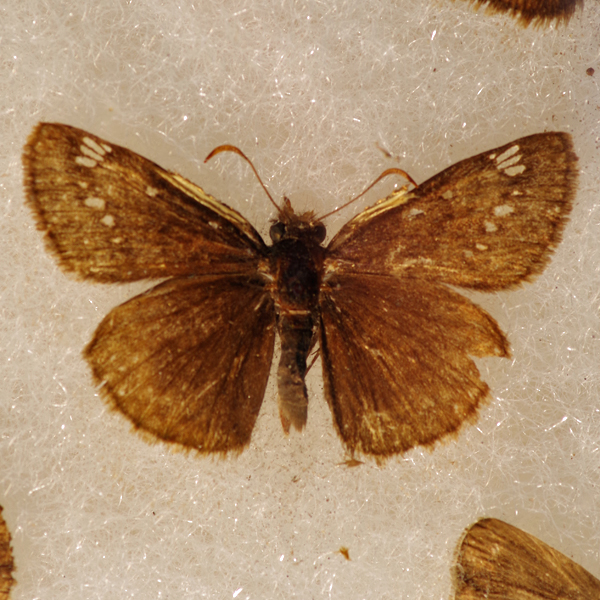
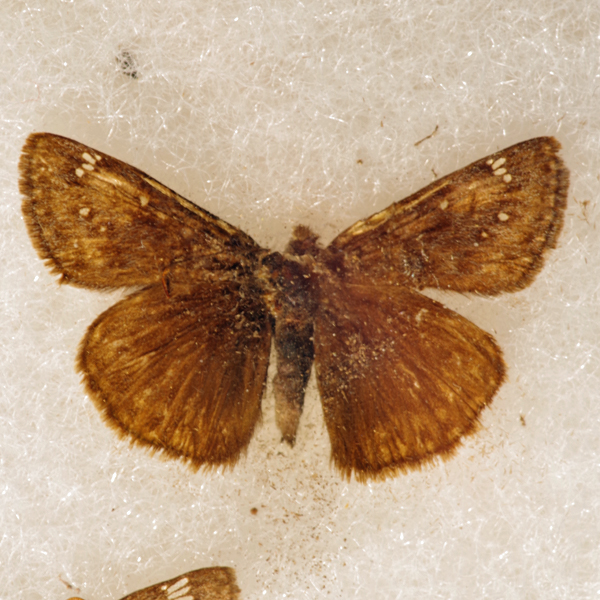
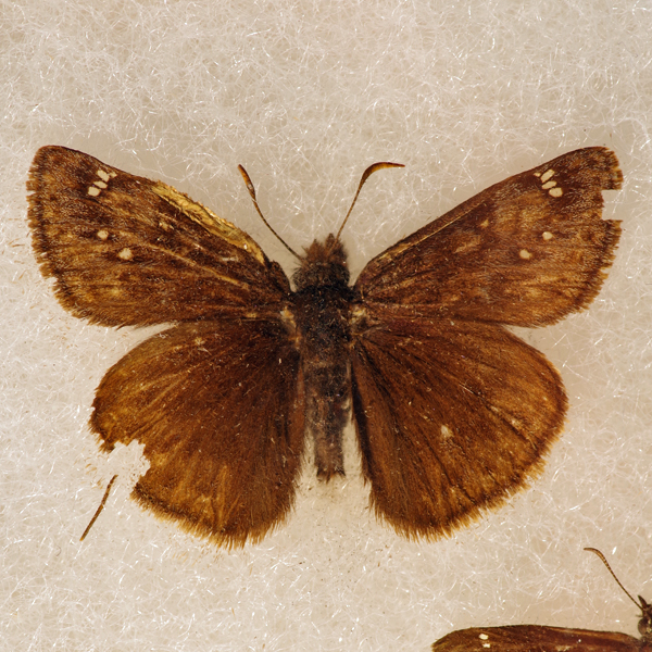
Juvenal's Duskywing (Erynnis juvenalis), (Fabricius, 1793) - 3947.000000 - 77a0143
Wing span: 3.5-4.0 cm.
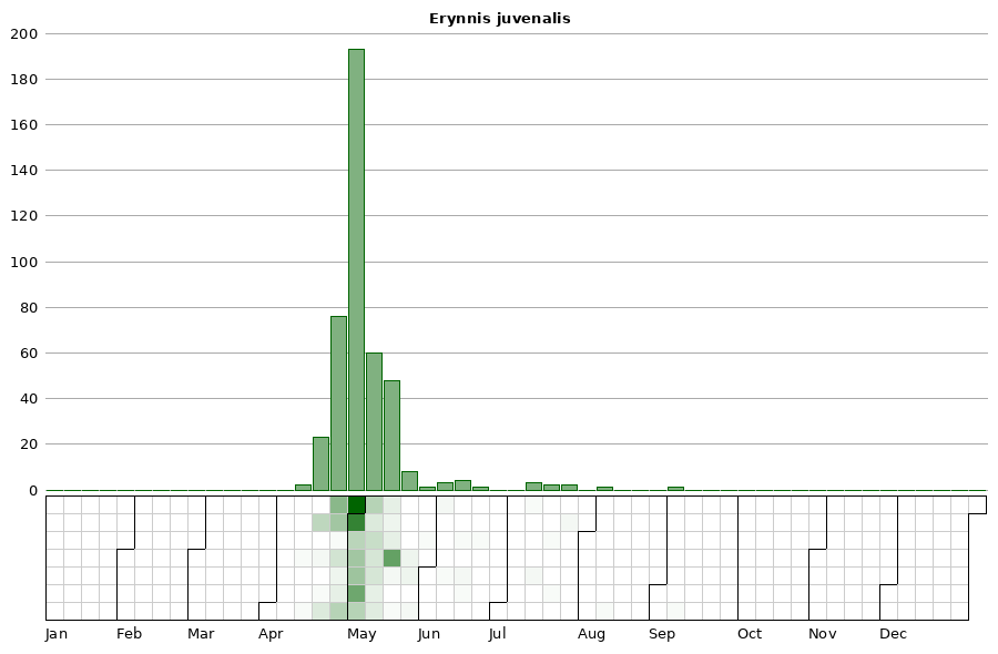
Flight time: A single flight occurring from mid-April to mid-June.
- Status:** Uncommon breeding resident.
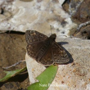
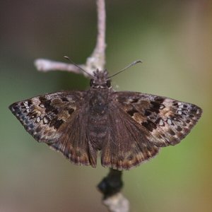
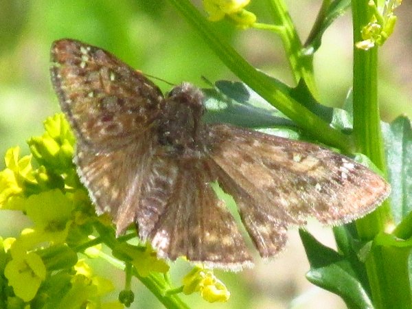
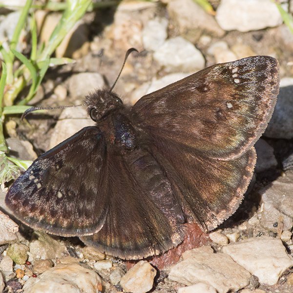
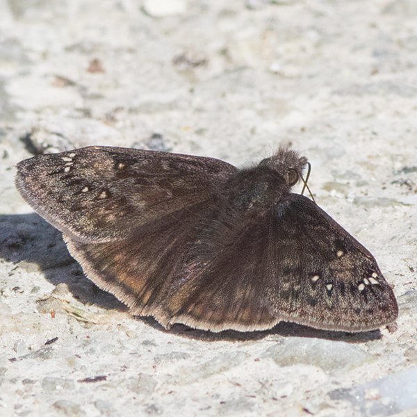
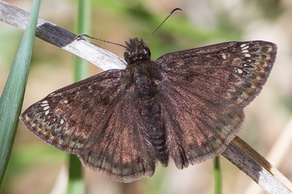
Distinguishing features: Juvenal's Duskywing is the only species of is genus in the state that has prominent hyaline spots on the fore wings with two subapical pale spots on the ventral hindwing.
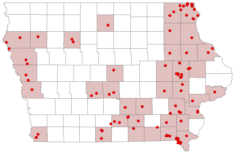
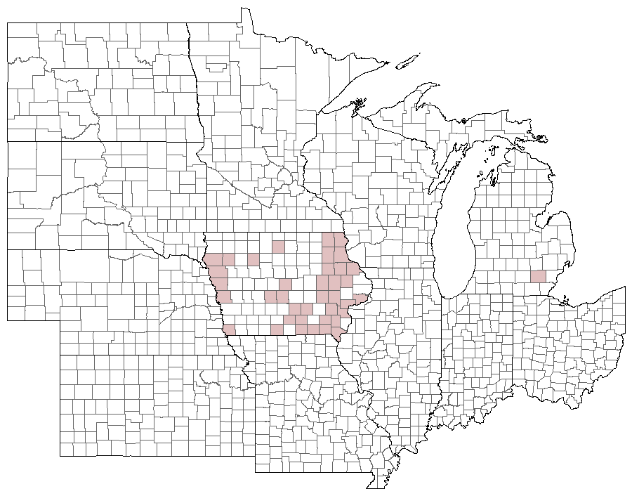
Distribution and habitat: . Juvenal's Dusky Wing has been found essentially across the entire state, although it appears to be more common in the eastern third. It occurs in a variety of oak-dominated forests, and may be more common in undisturbed forest habitats.
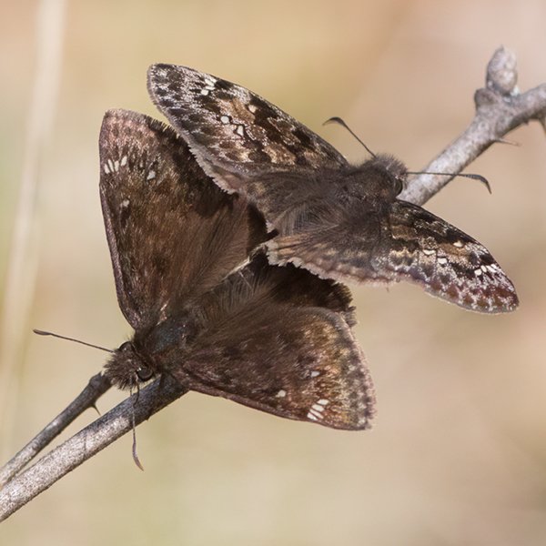
Natural History: The larvae of Juvenal's Duskywing feed on oaks and make leaf-nests. The adults are fast flyers and may often be seen resting on vegetation or puddling along roadsides and trails.
Photos
Records
| Record # | Date | Locale | State | Lat/Lon | Collected By | Count |
|---|---|---|---|---|---|---|
| 346435 | 2023-05-06 | Waubonsie State Park | Iowa | 40.670911 -95.693287 | Jay Gilliam | 1 |
 344317 344317
|
2023-05-04 | Shimek State Forest, Croton Unit East | Iowa | 40.545034 -91.615761 | Frank Olsen | 1 |
 341956 341956
|
2023-04-29 | Shimek State Forest, Lick Creek Unit | Iowa | 40.618542 -91.680006 | Mark Brown | 1 |
 342073 342073
|
2023-04-29 | Shimek State Forest, Lick Creek Unit | Iowa | 40.61776 -91.679637 | Mark Brown | 1 |
 346248 346248
|
2023-04-29 | Slip Bluff County Park | Iowa | 40.652884 -93.847544 | Jay Gilliam | 2 |
 346252 346252
|
2023-04-29 | Slip Bluff County Park | Iowa | 40.652884 -93.847544 | Jay Gilliam | 5 |
| 350078 | 2023-04-29 | Shimek State Forest, Croton Unit East | IA | 40.545896 -91.616881 | Chris Edwards | 2 |
| 350125 | 2023-04-29 | Shimek State Forest, Croton Unit West | IA | 40.566286 -91.658401 | Chris Edwards | 8 |
| 350139 | 2023-04-29 | Shimek State Forest, Donnellson Unit | IA | 40.643603 -91.67741 | Chris Edwards | 2 |
 317749 317749
|
2022-05-07 | Turkey Run Wildlife Area, Lee County | Iowa | 40.557863 -91.680371 | Jay Gilliam | 1 |
 317753 317753
|
2022-05-07 | Stephens State Forest- Mine Pond | Iowa | 41.016084 -93.479874 | Jay Gilliam | 3 |
| 327830 | 2022-05-07 | Port Louisa National Wildlife Refuge | Iowa | 41.239649 -91.124611 | IBSN | 1 |
 317739 317739
|
2022-05-01 | Slip Bluff County Park | Iowa | 40.652884 -93.847544 | Jay Gilliam | 9 |
 317725 317725
|
2022-04-24 | Slip Bluff County Park | Iowa | 40.652884 -93.847544 | Jay Gilliam | 6 |
| 304276 | 2021-05-07 | Port Louisa National Wildlife Refuge | Iowa | 41.239649 -91.124611 | IBSN | 1 |
 300363 300363
|
2021-04-24 | Slip Bluff County Park | Iowa | 40.652884 -93.847544 | Jay Gilliam | 4 |
| 300370 | 2021-04-24 | Stephens State Forest- Mine Pond | Iowa | 41.016084 -93.479874 | Jay Gilliam | 6 |
 287454 287454
|
2021-04-17 | Stephens State Forest - Thousand Acre Unit, Lucas County | Iowa | 41.104584 -93.101778 | Jay Gilliam | 1 |
| 274135 | 2020-05-02 | Shimek State Forest, Donnellson Unit | Iowa | 40.64741 -91.686584 | Frank Olsen | 1 |
| 280968 | 2020-05-01 | Shimek State Forest, Croton Unit East | Iowa | 40.545896 -91.616881 | Chris Edwards | 1 |
| 280969 | 2020-05-01 | Shimek State Forest, Croton Unit West | Iowa | 40.566286 -91.658401 | Chris Edwards | 2 |
| 280970 | 2020-05-01 | Shimek State Forest, Donnellson Unit | Iowa | 40.643603 -91.67741 | Chris Edwards | 2 |
| 280971 | 2020-05-01 | Shimek State Forest, Farmington Unit | Iowa | 40.653998 -91.72554 | Chris Edwards | 1 |
 275092 275092
|
2020-04-30 | Stephens State Forest - Thousand Acre Unit, Lucas County | Iowa | 41.103003 -93.101751 | Jay Gilliam | 1 |
 240270 240270
|
2019-05-04 | Shimek State Forest, Farmington Unit | Iowa | 40.64802 -91.7254 | Mark Brown | 1 |
| 248624 | 2019-04-26 | Shimek State Forest, Lacey Keosauqua Unit | Iowa | 40.704556 -92.012966 | Chris Edwards | 4 |
| 228437 | 2018-05-04 | Shimek State Forest, Croton Unit East | Iowa | 40.545896 -91.616881 | Chris Edwards | 6 |
| 228445 | 2018-05-04 | Shimek State Forest, Donnellson Unit | Iowa | 40.643603 -91.67741 | Chris Edwards | 2 |
| 228455 | 2018-05-04 | Shimek State Forest, Farmington Unit | Iowa | 40.653998 -91.72554 | Chris Edwards | 4 |
| 199369 | 2017-05-09 | Hitaga Sand Ridge Prairie Preserve | Iowa | 42.24944 -91.63056 | Frank Olsen | 2 |
| 202868 | 2017-05-07 | Stephens State Forest - Thousand Acre Unit, Monroe County | Iowa | 41.116843 -93.084809 | Chris Edwards | 1 |
| 199600 | 2017-05-05 | Rock Island Botanical State Preserve | Iowa | 42.0258 -91.72638 | Frank Olsen | 2 |
 201931 201931
|
2017-05-04 | Albia | Iowa | 41.02668 -92.80575 | Jacob Newton | 1 |
| 186772 | 2017-04-23 | Waubonsie State Park | Iowa | 40.676 -95.689 | Frank Olsen | 6 |
| 199866 | 2017-04-23 | Waubonsie State Park | Iowa | 40.676 -95.689 | Frank Olsen | 2 |
| 199872 | 2017-04-23 | Waubonsie State Park | Iowa | 40.676 -95.689 | Frank Olsen | 4 |
 186929 186929
|
2017-04-21 | Eldon Wildlife Management Area | Iowa | 40.893149 -92.264579 | Mark Brown | 1 |
| 202866 | 2017-04-17 | Shimek State Forest, Croton Unit East | Iowa | 40.545896 -91.616881 | Chris Edwards | 5 |
| 202867 | 2017-04-17 | Shimek State Forest, Farmington Unit | Iowa | 40.653998 -91.72554 | Chris Edwards | 6 |
| 202311 | 2017-04-15 | Decatur County, Iowa | Iowa | Location Protected | Sibylla Brown | 1 |
| 182137 | 2016-05-15 | Decatur County, Iowa | Iowa | Location Protected | Sibylla Brown | 1 |
| 182136 | 2016-05-08 | Decatur County, Iowa | Iowa | Location Protected | Sibylla Brown | 1 |
| 182135 | 2016-05-04 | Decatur County, Iowa | Iowa | Location Protected | Sibylla Brown | 1 |
| 182134 | 2016-04-23 | Decatur County, Iowa | Iowa | Location Protected | Sibylla Brown | 1 |
| 182133 | 2016-04-18 | Decatur County, Iowa | Iowa | Location Protected | Sibylla Brown | 1 |
| 182132 | 2016-04-16 | Decatur County, Iowa | Iowa | Location Protected | Sibylla Brown | 1 |
| 182131 | 2016-04-11 | Decatur County, Iowa | Iowa | Location Protected | Sibylla Brown | 1 |
| 358455 | 2015-09-09 | Red Oak Prairie | Iowa | 43.236675 -91.119145 | Kirk J. Larsen | 1 |
| 352862 | 2015-07-21 | Anderson Prairie, Decorah | Iowa | 43.315099 -91.800701 | Jacob Wittman | 1 |
| 136353 | 2015-05-13 | Decatur County, Iowa | Iowa | Location Protected | Sibylla Brown | 4 |
| 136352 | 2015-05-08 | Decatur County, Iowa | Iowa | Location Protected | Sibylla Brown | 4 |
| 136351 | 2015-05-07 | Decatur County, Iowa | Iowa | Location Protected | Sibylla Brown | 2 |
| 136350 | 2015-05-06 | Decatur County, Iowa | Iowa | Location Protected | Sibylla Brown | 5 |
| 183435 | 2015-05-04 | Lacey-Keosauqua State Park | Iowa | 40.712037 -91.976555 | Chris Edwards | 1 |
| 136349 | 2015-04-29 | Decatur County, Iowa | Iowa | Location Protected | Sibylla Brown | 1 |
| 183425 | 2015-04-27 | Shimek State Forest, Farmington Unit | Iowa | 40.653998 -91.72554 | Chris Edwards | 2 |
| 356325 | 2013-06-13 | Allamakee County, Iowa | Iowa | Location Protected | Kirk J. Larsen | 1 |
| 8400 | 2013-05-12 | Shimek State Forest, Donnellson Unit | Iowa | 40.6505556 -91.6866667 | Tom Jantscher | 1 |
| 8401 | 2013-05-12 | Shimek State Forest, Donnellson Unit | Iowa | 40.6427778 -91.6936111 | Tom Jantscher | 1 |
| 8402 | 2013-05-12 | Shimek State Forest, Donnellson Unit | Iowa | 40.6461111 -91.6877778 | Tom Jantscher | 1 |
| 8399 | 2013-04-28 | Shimek State Forest, Donnellson Unit | Iowa | 40.6455556 -91.69 | Tom Jantscher | 1 |
| 8410 | 2012-04-21 | Lacey-Keosauqua State Park | Iowa | 40.7163889 -91.9902778 | Tom Jantscher | 1 |
| 8403 | 2011-05-08 | Shimek State Forest, Lick Creek Unit | Iowa | 40.6294444 -91.6988889 | Tom Jantscher | 1 |
 25904 25904
|
2010-06-20 | Des Moines-x | Iowa | 41.59 -93.62611 | Leland Searles | 1 |
 228041 228041
|
2010-05-09 | Lacey-Keosauqua State Park | Iowa | 40.7125 -91.9944444 | Jim Durbin | 1 |
| 55094 | 2010-04-29 | Yellow River State Forest | Iowa | 43.17253 -91.25173 | Frank Olsen | 1 |
 228063 228063
|
2010-04-23 | Leon's Farm, Ohio County | Kentucky | 37.42033 -86.77023 | Jim Durbin | 1 |
| 6823 | 2009-05-20 | Stephens State Forest - Woodburn Unit | Iowa | 40.96446 -93.579119 | Aaron Brees | 1 |
 207891 207891
|
2009-05-09 | Shimek State Forest, Croton Unit East | Iowa | 40.5686111 -91.6038889 | Aaron Brees | 6 |
 266215 266215
|
2009-05-08 | Lacey-Keosauqua State Park | Iowa | 40.71523215 -91.99018841 | Jim Durbin | 1 |
| 6821 | 2009-05-03 | Stephens State Forest - Thousand Acre Unit, Lucas County | Iowa | 41.103003 -93.101751 | Aaron Brees | 5 |
| 6822 | 2009-05-03 | Stephens State Forest - Woodburn Unit | Iowa | 40.96446 -93.579119 | Aaron Brees | 5 |
 138481 138481
|
2008-05-14 | Decatur County | Iowa | 40.814648 -93.824821 | Aaron Brees | 1 |
 207890 207890
|
2008-05-14 | Decatur Wildlife Management Area | Iowa | 40.830629 -93.85059 | Aaron Brees | 1 |
| 55080 | 2007-05-25 | Ryan Property | Iowa | 43.35833 -91.6005 | Frank Olsen | 3 |
| 55081 | 2006-05-06 | Shimek State Forest, Croton Unit East | Iowa | 40.54693 -91.61435 | Doug Veal | 1 |
| 55056 | 2006-05-02 | Whispering Pines Hill Prairie | Iowa | 43.427166 -91.287898 | Frank Olsen | 3 |
 25903 25903
|
2006-05-01 | Shimek State Forest, Donnellson Unit | Iowa | 40.64833 -91.68057 | Jim Durbin | 1 |
| 55090 | 2006-04-26 | Waubonsie State Park | Iowa | 40.676 -95.689 | Frank Olsen | 3 |
| 55067 | 2005-05-30 | Kuehn Connservation Area | Iowa | 41.562794 -94.12889 | Keith Summerville | 1 |
| 114650 | 2005-05-16 | Shimek State Forest, Lick Creek Unit | Iowa | 40.61233 -91.685905 | Chris Edwards | 1 |
 25902 25902
|
2005-05-10 | Shimek State Forest, Croton Unit East | Iowa | 40.54693 -91.61435 | Jim Durbin | 1 |
| 55076 | 2005-05-03 | Rock Island Botanical State Preserve | Iowa | 42.02732 -91.72723 | Frank Olsen | 1 |
| 55084 | 2005-04-25 | Wanatee County Park | Iowa | 42.00994 -91.57749 | Frank Olsen | 1 |
| 114656 | 2005-04-19 | Lake MacBride State Park | Iowa | 41.800146 -91.555669 | Chris Edwards | 1 |
| 55068 | 2004-05-05 | Heritage Pond / Heritage Trail | Iowa | 42.556 -90.70783 | Frank Olsen | 2 |
| 55069 | 2004-05-04 | Matsell Bridge Natural Area | Iowa | 42.13131 -91.38886 | Frank Olsen | 1 |
| 55070 | 2004-05-04 | Matsell Bridge Natural Area | Iowa | 42.13131 -91.38886 | Frank Olsen | 4 |
| 55082 | 2004-05-03 | Wanatee County Park | Iowa | 42.00994 -91.57749 | Frank Olsen | 1 |
| 114657 | 2003-05-03 | Beam's Woods | Iowa | 42.142425 -91.343915 | Chris Edwards | 1 |
| 55091 | 2003-04-22 | Waubonsie State Park | Iowa | 40.676 -95.689 | Frank Olsen | 6 |
| 55064 | 2002-05-14 | Honey Creek State Park | Iowa | 40.86526 -92.94011 | Frank Olsen | 5 |
| 114654 | 2002-05-13 | Lake Darling State Park | Iowa | 41.187385 -91.901158 | Chris Edwards | 1 |
| 55062 | 2002-05-05 | Honey Creek State Park | Iowa | 40.86526 -92.94011 | Frank Olsen | 22 |
| 271752 | 2002-05-04 | Rock Island Botanical State Preserve | Iowa | 42.02732 -91.72723 | Dennis Schlicht | 3 |
| 55075 | 2002-05-03 | Rock Island Botanical State Preserve | Iowa | 42.02732 -91.72723 | Frank Olsen | 3 |
| 114658 | 2002-04-26 | Dudgeon Lake Wildlife Management Area | Iowa | 42.196085 -92.034766 | Chris Edwards | 1 |
| 55063 | 2002-04-23 | Honey Creek State Park | Iowa | 40.86526 -92.94011 | Frank Olsen | 11 |
| 114659 | 2001-05-18 | Hitaga Sand Ridge Prairie Preserve | Iowa | 42.253227 -91.632041 | Chris Edwards | 2 |
| 114660 | 2001-05-17 | Yellow River State Forest | Iowa | 43.170603 -91.240395 | Chris Edwards | 30 |
| 114652 | 2001-04-30 | Fern Cliff County Park | Iowa | 41.201811 -91.609179 | Chris Edwards | 10 |
| 114653 | 2001-04-30 | Lake Darling State Park | Iowa | 41.187385 -91.901158 | Chris Edwards | 2 |
| 114655 | 2001-04-30 | Sockum Ridge County Park | Iowa | 41.21756 -91.653049 | Chris Edwards | 40 |
 25899 25899
|
2000-07-23 | Shimek State Forest, Croton Unit East | Iowa | 40.54693 -91.61435 | Jim Durbin | 1 |
 240061 240061
|
2000-07-23 | Shimek State Forest, Croton Unit East | Iowa | 40.54693 -91.61435 | Jim Durbin | 1 |
 25898 25898
|
2000-07-17 | Shimek State Forest, Croton Unit East | Iowa | 40.54693 -91.61435 | Jim Durbin | 1 |
| 25900 | 2000-06-15 | Shimek State Forest, Croton Unit East | Iowa | 40.54693 -91.61435 | Jim Durbin | 1 |
| 144484 | 2000-05-02 | Wanatee County Park | Iowa | 42.00994 -91.57749 | Frank Olsen | 1 |
| 114649 | 1999-05-11 | Shimek State Forest, Lick Creek Unit | Iowa | 40.61233 -91.685905 | Chris Edwards | 1 |
| 114651 | 1999-05-10 | Lacey-Keosauqua State Park | Iowa | 40.712037 -91.976555 | Chris Edwards | 2 |
| 55093 | 1998-07-13 | Winneshiek County | Iowa | 43.23626 -91.90993 | 1 | |
| 352861 | 1998-07-13 | Anderson Prairie, Decorah | Iowa | 43.315099 -91.800701 | Jennifer Bovee | 1 |
| 55092 | 1998-06-15 | Winneshiek County | Iowa | 43.23626 -91.90993 | 1 | |
| 358600 | 1998-06-15 | South Bear Creek along Quandahl Rd-x | Iowa | 43.439722 -91.624444 | Jennifer Bovee | 1 |
| 55061 | 1992-05-08 | Hitaga Sand Ridge Prairie Preserve | Iowa | 42.25233 -91.63633 | Frank Olsen | 1 |
| 55083 | 1991-05-11 | Wanatee County Park | Iowa | 42.00994 -91.57749 | Frank Olsen | 5 |
| 144347 | 1991-05-08 | Hitaga Sand Ridge Prairie Preserve | Iowa | 42.24944 -91.63056 | Frank Olsen | 1 |
| 55079 | 1991-05-07 | Rock Island Botanical State Preserve | Iowa | 42.02732 -91.72723 | Frank Olsen | 1 |
| 55085 | 1991-04-27 | Wanatee County Park | Iowa | 42.00994 -91.57749 | Frank Olsen | 1 |
| 55078 | 1990-05-13 | Rock Island Botanical State Preserve | Iowa | 42.02732 -91.72723 | Frank Olsen | 1 |
| 55077 | 1990-05-11 | Rock Island Botanical State Preserve | Iowa | 42.02732 -91.72723 | Frank Olsen | 1 |
| 124740 | 1990-05-01 | Shaver Park, Cedar Rapids | Iowa | 42.002284 -91.675458 | Frank Olsen | 2 |
| 124738 | 1990-04-29 | Matsell Bridge Natural Area | Iowa | 42.13131 -91.38886 | Frank Olsen | 3 |
 144302 144302
|
1990-04-29 | Matsell Bridge Natural Area | Iowa | 42.131126 -91.388999 | Frank Olsen | 1 |
| 107041 | 1990-04-24 | Pocahontas County | Iowa | 42.74456 -94.683864 | Ron Harms | 1 |
| 107042 | 1990-04-24 | Pocahontas County | Iowa | 42.74456 -94.683864 | Ron Harms | 1 |
| 124549 | 1989-08-12 | Wanatee County Park | Iowa | 42.00994 -91.57749 | Frank Olsen | 1 |
| 124317 | 1989-06-04 | Matsell Bridge Natural Area | Iowa | 42.13131 -91.38886 | Frank Olsen | 1 |
 144257 144257
|
1989-06-04 | Matsell Bridge Natural Area | Iowa | 42.131126 -91.388999 | Frank Olsen | 1 |
| 124298 | 1989-05-27 | Sac and Fox Trail City Park | Iowa | 41.946803 -91.611754 | Frank Olsen | 1 |
 144254 144254
|
1989-05-27 | Indian Creek Nature Center | Iowa | 41.963207 -91.586629 | Frank Olsen | 1 |
| 124287 | 1989-05-15 | Shaver Park, Cedar Rapids | Iowa | 42.002284 -91.675458 | Frank Olsen | 1 |
| 124285 | 1989-05-12 | Wanatee County Park | Iowa | 42.00994 -91.57749 | Frank Olsen | 1 |
 144252 144252
|
1989-05-12 | Wanatee County Park | Iowa | 42.00994 -91.57749 | Frank Olsen | 1 |
| 55074 | 1989-05-07 | Preparation Canyon State Park | Iowa | 41.89133 -95.91407 | Tim Orwig | 1 |
| 124277 | 1989-05-07 | Matsell Bridge Natural Area | Iowa | 42.13131 -91.38886 | Frank Olsen | 3 |
 144249 144249
|
1989-05-07 | Matsell Bridge Natural Area | Iowa | 42.131126 -91.388999 | Frank Olsen | 1 |
| 55088 | 1989-05-06 | Stone State Park | Iowa | 42.55333 -96.46194 | Tim Orwig | 1 |
| 55072 | 1988-05-23 | Mount Hosmer Park | Iowa | 43.36597 -91.22188 | J. Nehuevaj | 1 |
| 357902 | 1988-05-23 | Mount Hosmer Park | Iowa | 43.363887 -91.221697 | John G. Nehnevaj | 1 |
| 357904 | 1988-05-23 | Mount Hosmer Park | Iowa | 43.363887 -91.221697 | John G. Nehnevaj | 1 |
| 107039 | 1988-05-16 | Fowler Forest Preserve | Iowa | 42.232523 -95.945211 | Tim Orwig | 1 |
| 107040 | 1988-05-16 | Fowler Forest Preserve | Iowa | 42.232523 -95.945211 | Tim Orwig | 1 |
| 55071 | 1988-05-15 | Mount Hosmer Park | Iowa | 43.36597 -91.22188 | J. Nehuevaj | 1 |
| 353408 | 1988-05-15 | Junction of Bear Creek and Bear Creek Rd | Iowa | 43.432333 -91.526833 | John G. Nehnevaj | 1 |
| 353409 | 1988-05-15 | Junction of Bear Creek and Bear Creek Rd | Iowa | 43.432333 -91.526833 | John G. Nehnevaj | 1 |
| 55057 | 1988-05-05 | Fish Farm Mounds Wildlife Area | Iowa | 43.4331 -91.2842 | J. Nehuevaj | 1 |
| 353406 | 1988-05-05 | Junction of Bear Creek and Bear Creek Rd | Iowa | 43.432333 -91.526833 | John G. Nehnevaj | 1 |
| 353407 | 1988-05-05 | Junction of Bear Creek and Bear Creek Rd | Iowa | 43.432333 -91.526833 | John G. Nehnevaj | 1 |
| 355119 | 1988-05-05 | Black Hawk Point Wildlife Management Area | Iowa | 43.457233 -91.281109 | John G. Nehnevaj | 1 |
| 356389 | 1988-05-05 | Black Hawk Point Wildlife Management Area | Iowa | 43.469016 -91.30228 | John G. Nehnevaj | 1 |
| 55086 | 1988-05-02 | Stone State Park | Iowa | 42.55333 -96.46194 | Tim Orwig | 1 |
| 55087 | 1988-05-02 | Stone State Park | Iowa | 42.55333 -96.46194 | Tim Orwig | 1 |
| 55059 | 1988-05-01 | Five Ridge Prairie State Preserve | Iowa | 42.67867 -96.53473 | Tim Orwig | 1 |
| 55060 | 1988-05-01 | Five Ridge Prairie State Preserve | Iowa | 42.67867 -96.53473 | Tim Orwig | 1 |
| 55065 | 1988-05-01 | Junction of Bear Creek and Hwy76 | Iowa | 43.43352 -91.5191 | J. Nehuevaj | 1 |
| 55066 | 1988-05-01 | Black Hawk Point Wildlife Management Area | Iowa | 43.46996 -91.29466 | J. Nehuevaj | 1 |
| 357903 | 1988-05-01 | Mount Hosmer Park | Iowa | 43.363887 -91.221697 | John G. Nehnevaj | 1 |
| 55058 | 1987-04-30 | Five Ridge Prairie State Preserve | Iowa | 42.67867 -96.53473 | Tim Orwig | 1 |
| 358834 | 1983-06-08 | Stinchfield Woods | Michigan | 42.4008 -83.922158 | Kirk J. Larsen | 1 |
| 55073 | 1983-05-10 | Mount Hosmer Park | Iowa | 43.36597 -91.22188 | J. Nehuevaj | 1 |
| 55089 | 1983-05-10 | Clear Creek Fen | Iowa | 43.455306 -91.42388 | J. Nehuevaj | 1 |
| 357900 | 1983-05-10 | Mount Hosmer Park | Iowa | 43.363887 -91.221697 | John G. Nehnevaj | 1 |
| 357901 | 1983-05-10 | Mount Hosmer Park | Iowa | 43.363887 -91.221697 | John G. Nehnevaj | 1 |
| 358083 | 1983-05-10 | Potter's Prairie | Iowa | 43.4825 -91.412333 | John G. Nehnevaj | 1 |
| 3013 | 1950-05-01 | Allamakee County | Iowa | 43.243076 -91.443466 | USGS - NPWRC | 1 |
| 3014 | 1950-05-01 | Buchanan County | Iowa | 42.4566 -91.909927 | USGS - NPWRC | 1 |
| 3015 | 1950-05-01 | Cherokee County | Iowa | 42.802776 -95.645798 | USGS - NPWRC | 1 |
| 3016 | 1950-05-01 | Clayton County | Iowa | 42.77853 -91.289101 | USGS - NPWRC | 1 |
| 3017 | 1950-05-01 | Dallas County | Iowa | 41.612003 -93.987846 | USGS - NPWRC | 1 |
| 3018 | 1950-05-01 | Delaware County | Iowa | 42.463402 -91.443466 | USGS - NPWRC | 1 |
| 3019 | 1950-05-01 | Dubuque County | Iowa | 42.469467 -90.829399 | USGS - NPWRC | 1 |
| 3020 | 1950-05-01 | Fayette County | Iowa | 42.925819 -91.909927 | USGS - NPWRC | 1 |
| 3021 | 1950-05-01 | Sidney | Iowa | 40.74004 -95.645798 | USGS - NPWRC | 1 |
| 3022 | 1950-05-01 | Hancock County | Iowa | 43.038731 -93.662323 | USGS - NPWRC | 1 |
| 3023 | 1950-05-01 | Harrison County | Iowa | 41.693386 -95.814285 | USGS - NPWRC | 1 |
| 3024 | 1950-05-01 | Henry County | Iowa | 41.028358 -91.598396 | USGS - NPWRC | 1 |
| 3025 | 1950-05-01 | Iowa County | Iowa | 41.66246 -92.066521 | USGS - NPWRC | 1 |
| 3026 | 1950-05-01 | Johnson County | Iowa | 41.669899 -91.598396 | USGS - NPWRC | 1 |
| 3027 | 1950-05-01 | Lee County | Iowa | 40.706867 -91.443466 | USGS - NPWRC | 1 |
| 3028 | 1950-05-01 | Linn County | Iowa | 42.027289 -91.67275 | USGS - NPWRC | 1 |
| 3029 | 1950-05-01 | Lucas County | Iowa | 40.991203 -93.33889 | USGS - NPWRC | 1 |
| 3030 | 1950-05-01 | Mahaska County | Iowa | 41.32959 -92.698387 | USGS - NPWRC | 1 |
| 3031 | 1950-05-01 | Marion County | Iowa | 41.317383 -93.177963 | USGS - NPWRC | 1 |
| 3032 | 1950-05-01 | Monona County | Iowa | 42.001595 -95.983261 | USGS - NPWRC | 1 |
| 3033 | 1950-05-01 | Plymouth County | Iowa | 42.776665 -96.152695 | USGS - NPWRC | 1 |
| 3034 | 1950-05-01 | Pocahontas County | Iowa | 42.691803 -94.645035 | USGS - NPWRC | 1 |
| 3035 | 1950-05-01 | Polk County | Iowa | 41.627842 -93.500343 | USGS - NPWRC | 1 |
| 3036 | 1950-05-01 | Scott County | Iowa | 41.63932 -90.639374 | USGS - NPWRC | 1 |
| 3037 | 1950-05-01 | Story County | Iowa | 42.104046 -93.500343 | USGS - NPWRC | 1 |
| 3038 | 1950-05-01 | Van Buren County | Iowa | 40.700115 -91.909927 | USGS - NPWRC | 1 |
| 3039 | 1950-05-01 | Washington County | Iowa | 41.347797 -91.753883 | USGS - NPWRC | 1 |
| 3040 | 1950-05-01 | Winneshiek County | Iowa | 43.236259 -91.909927 | USGS - NPWRC | 1 |
| 3041 | 1950-05-01 | Woodbury County | Iowa | 42.316616 -95.983261 | USGS - NPWRC | 1 |