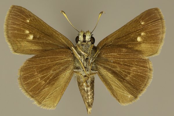
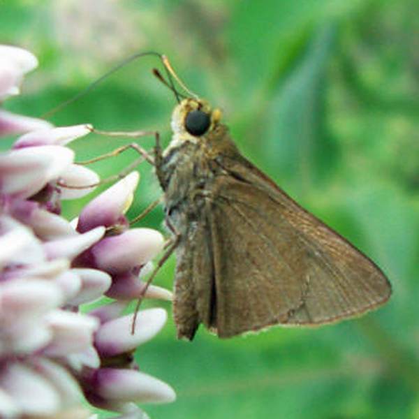
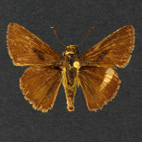
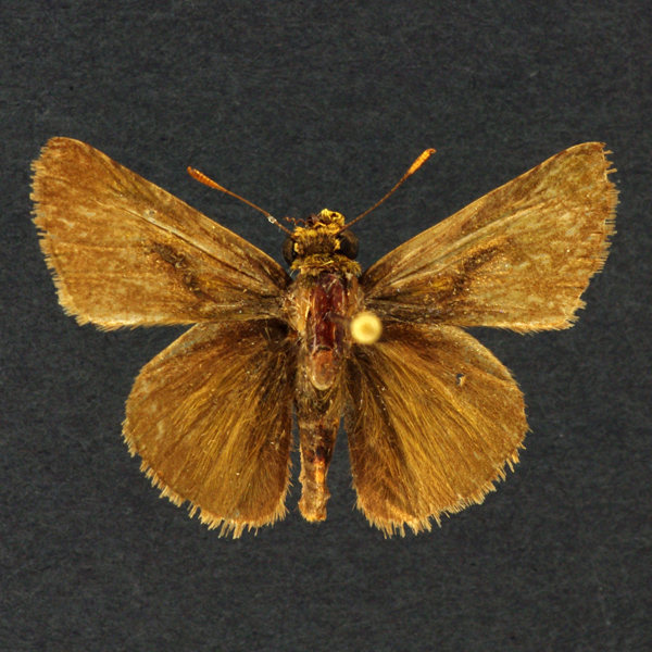
Wing span:
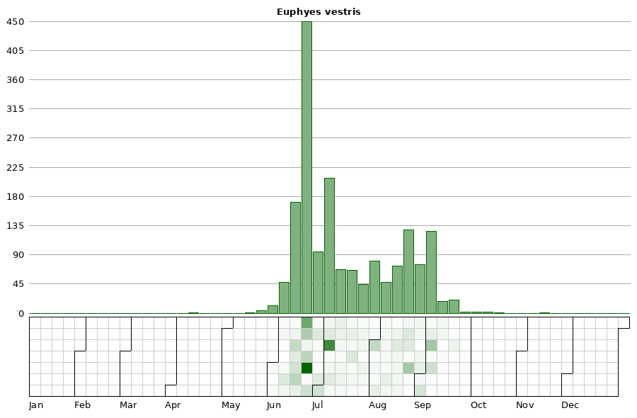
Flight time:Adults have been observed in flight from late May through the first of September, with the bulk of encounters occurring in the first half of July. While this species likely has multiple broods, collection records do not clearly indicate when these might occur. Perhaps there is only a single adult brood, which emerges over an extended period in the summer.
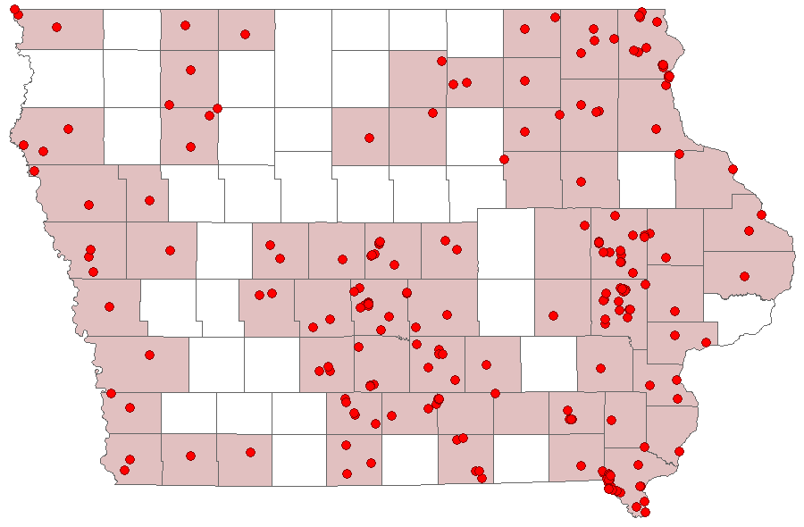
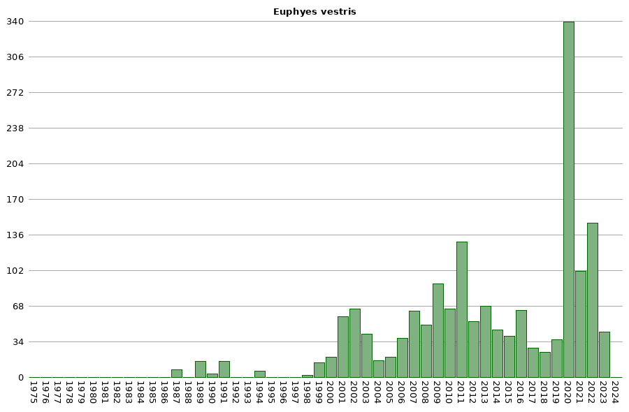
Status: Common breeding resident.
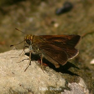
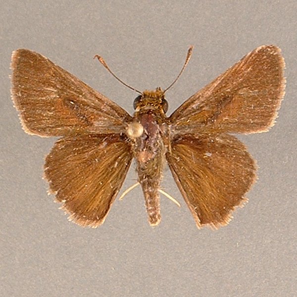
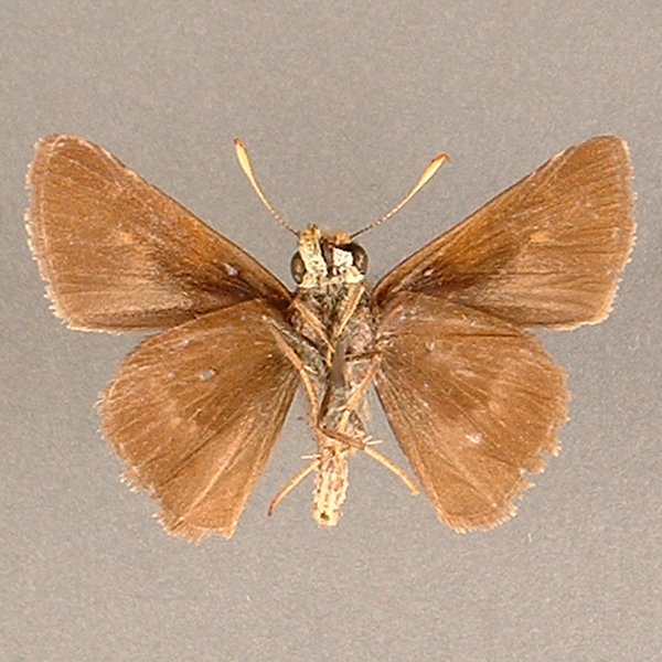
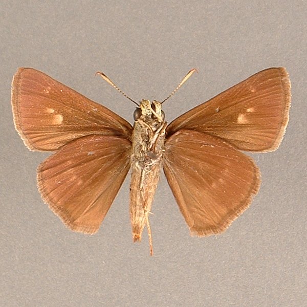
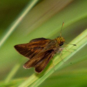
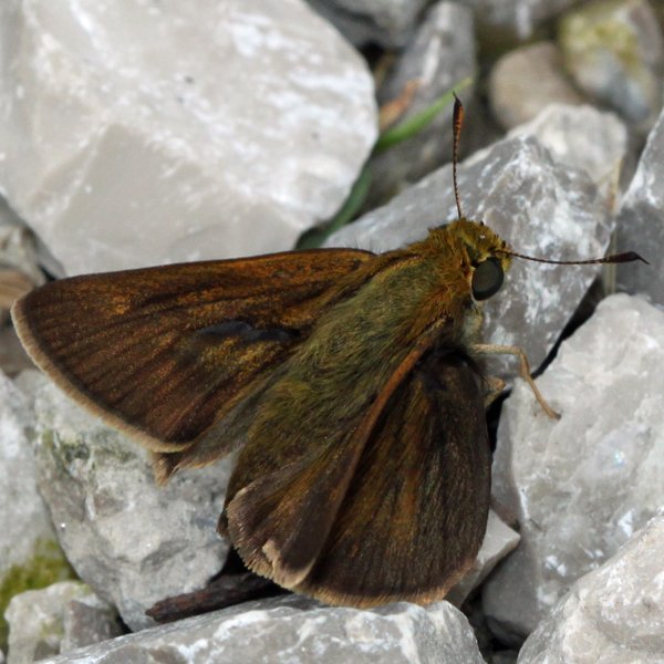
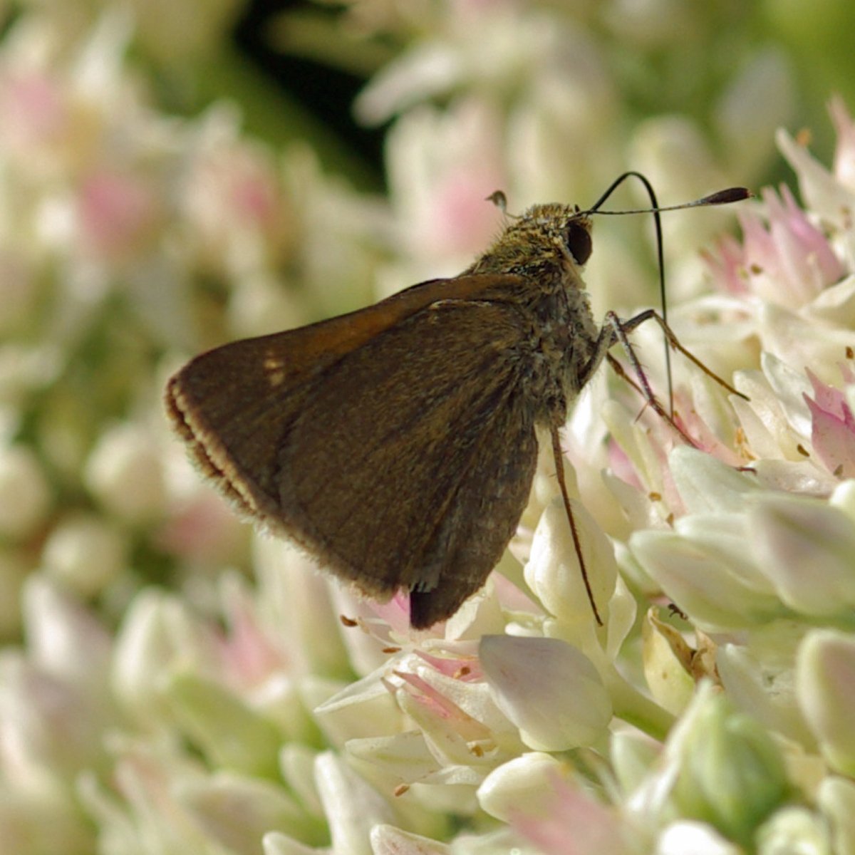
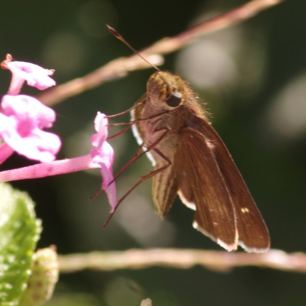
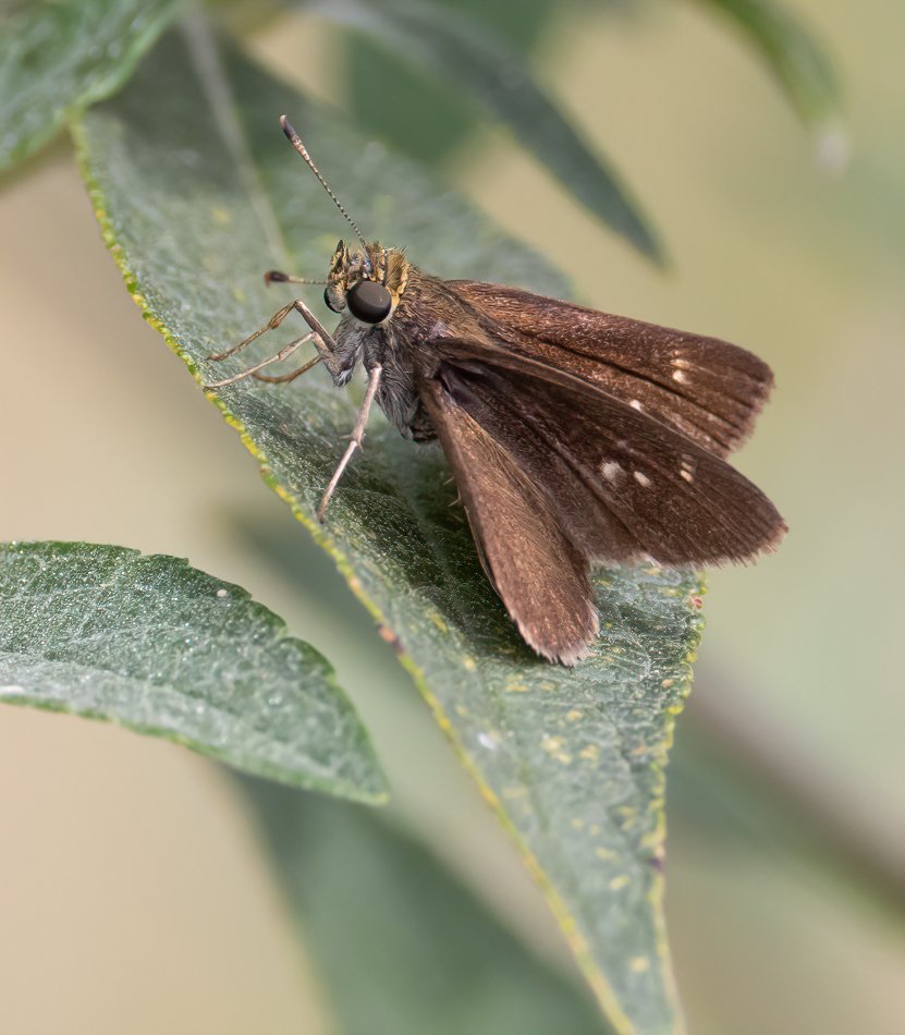
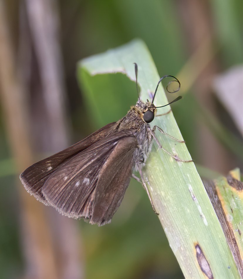
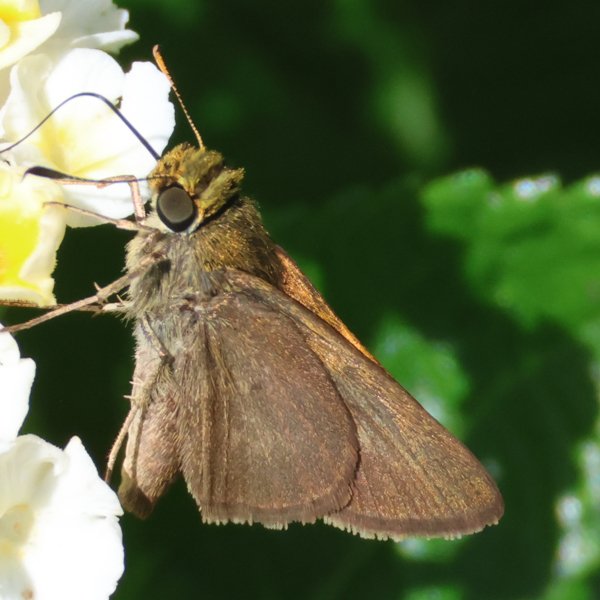
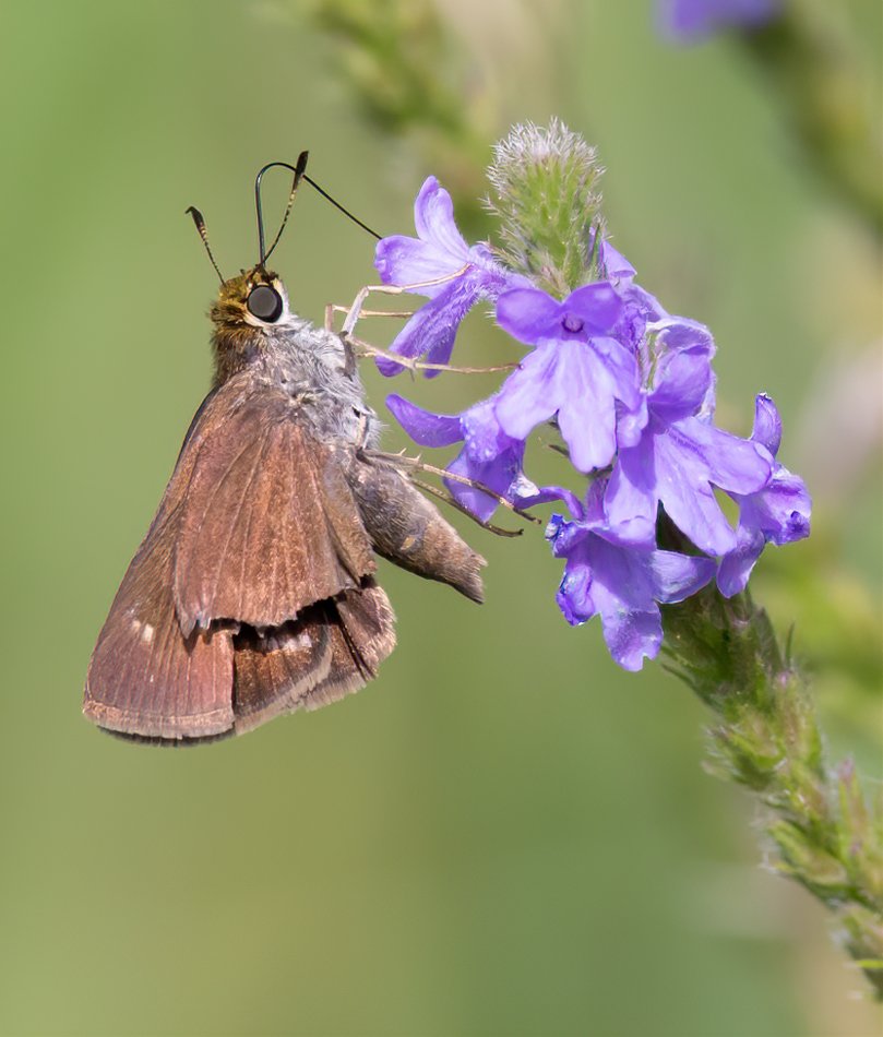
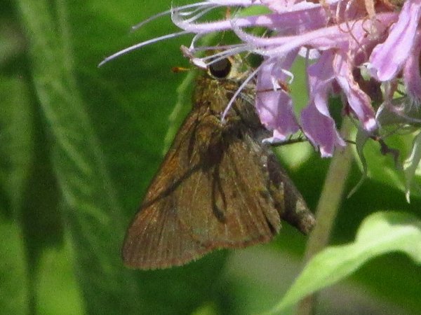
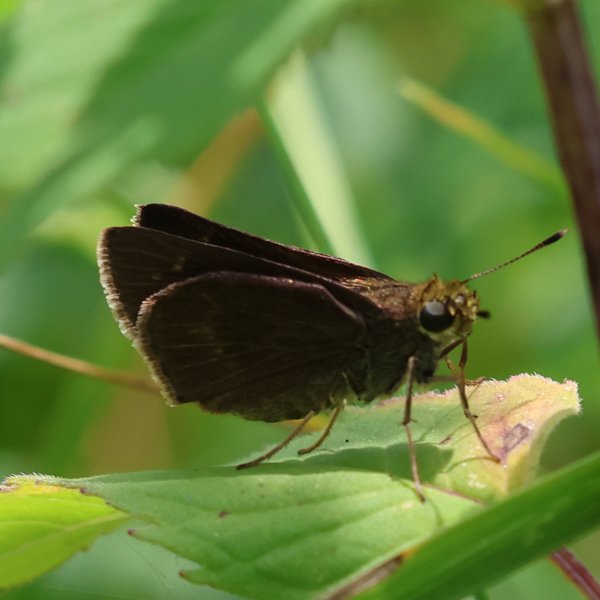
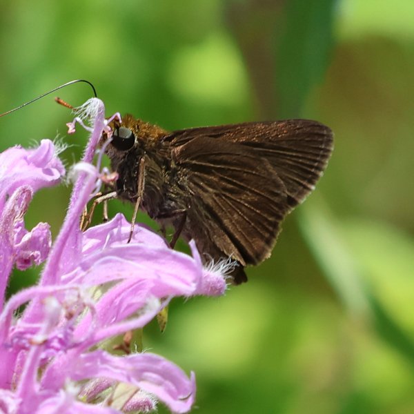
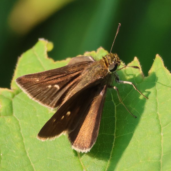
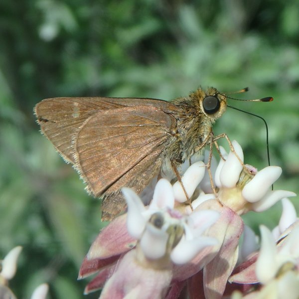
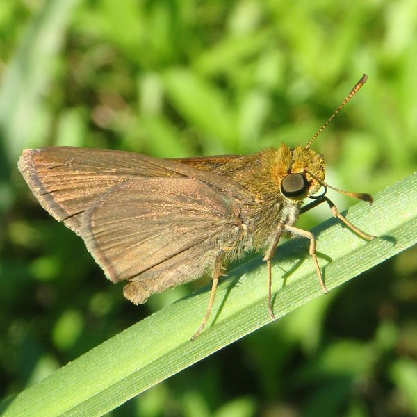
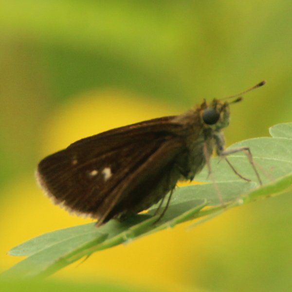
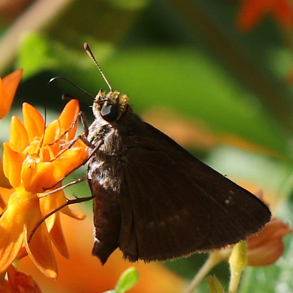
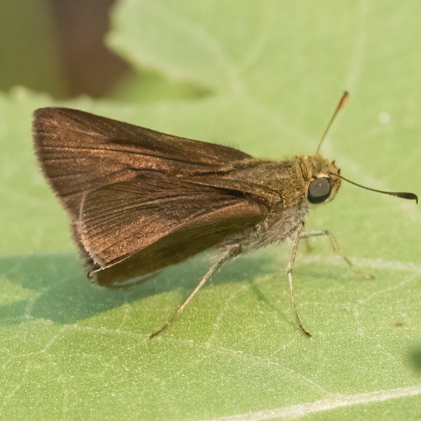
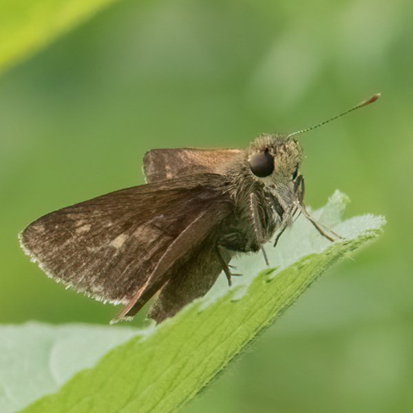
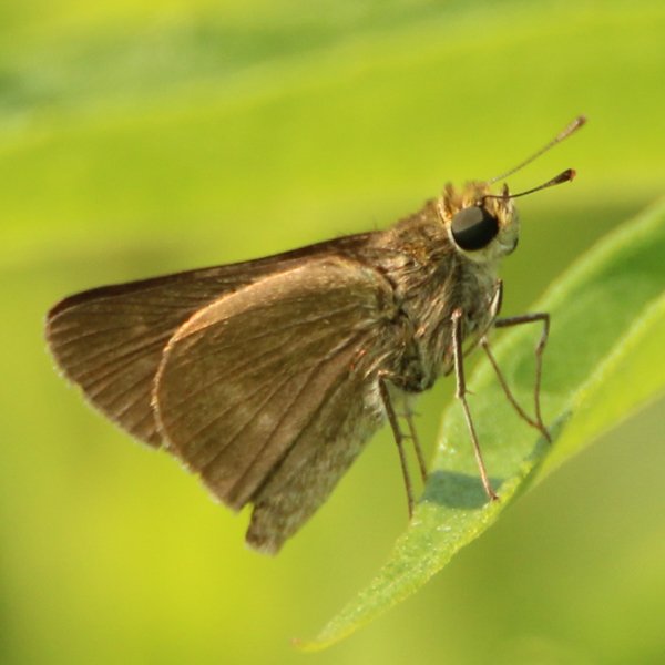
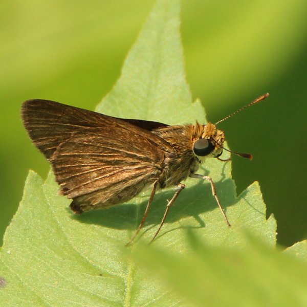
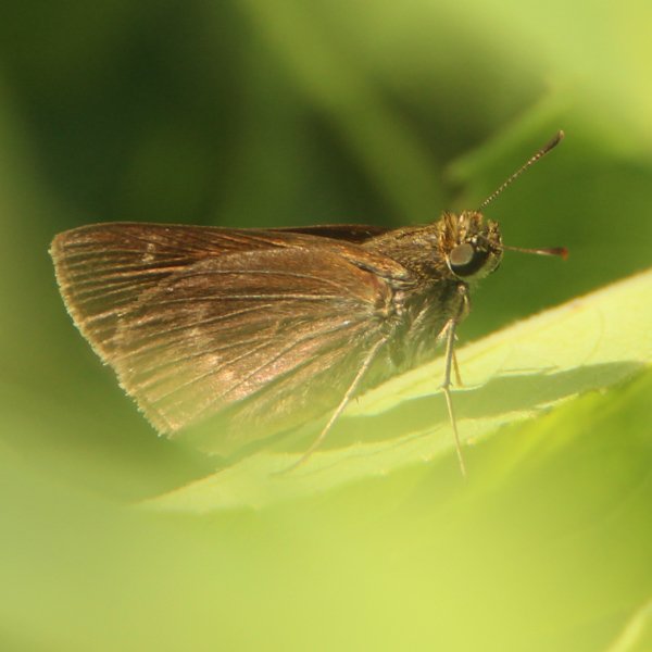
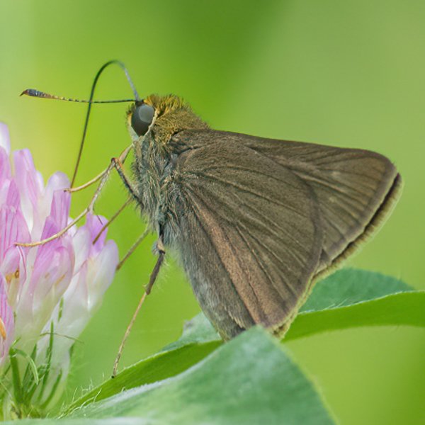
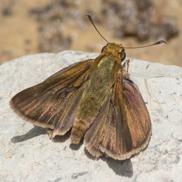
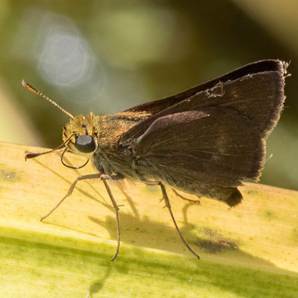
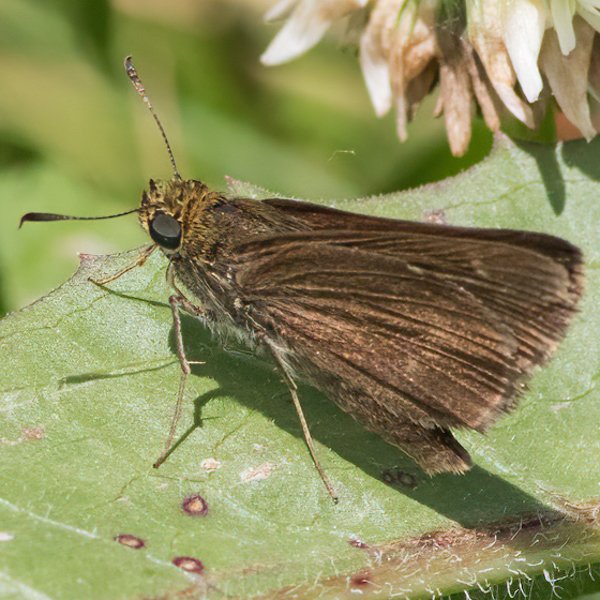
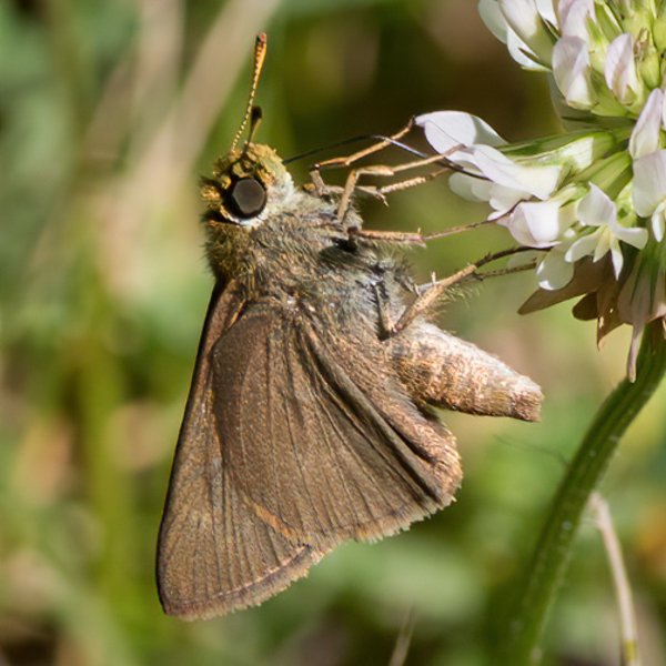
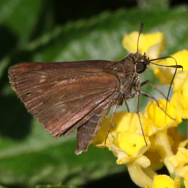
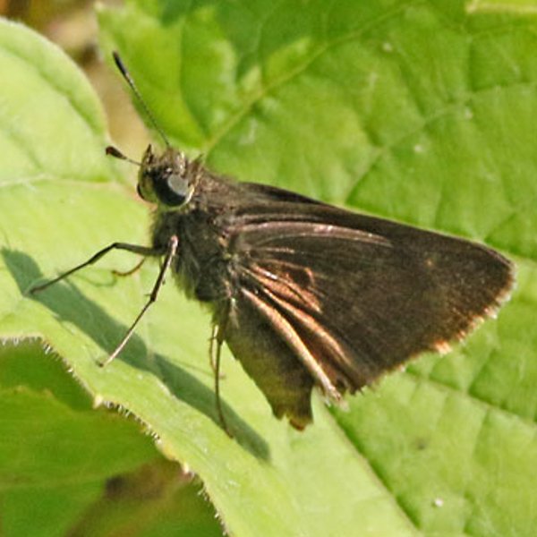
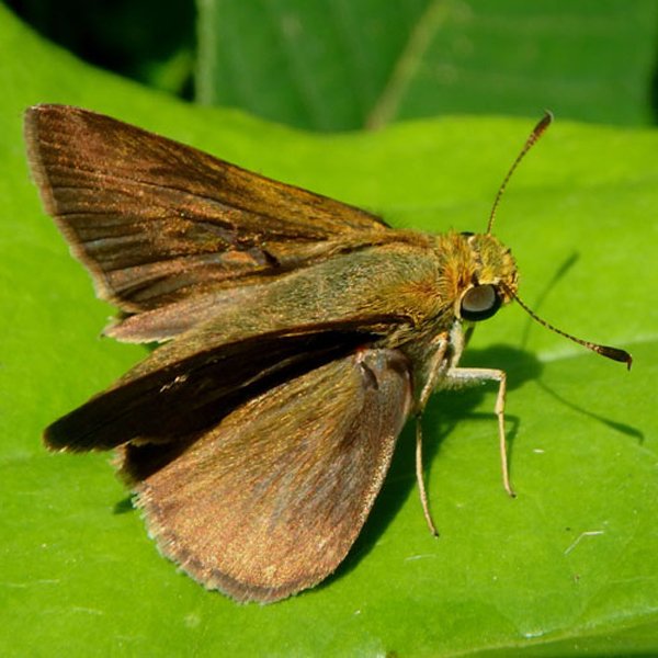
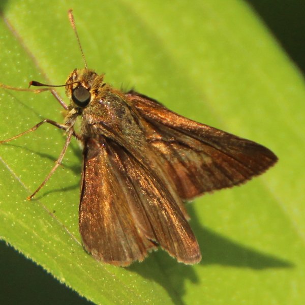
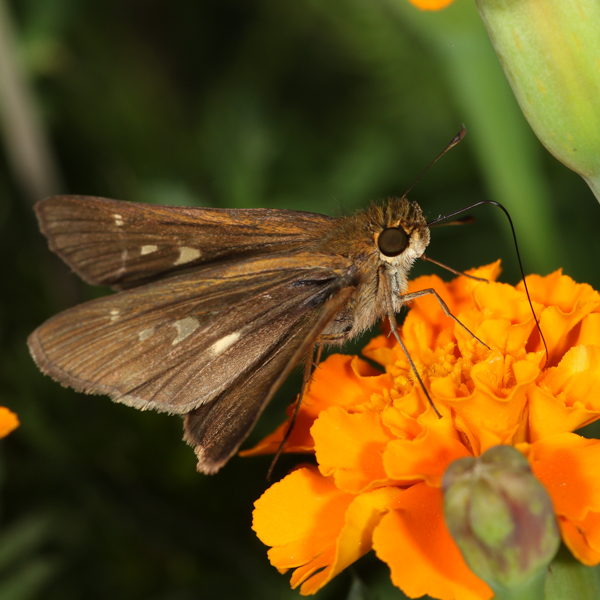
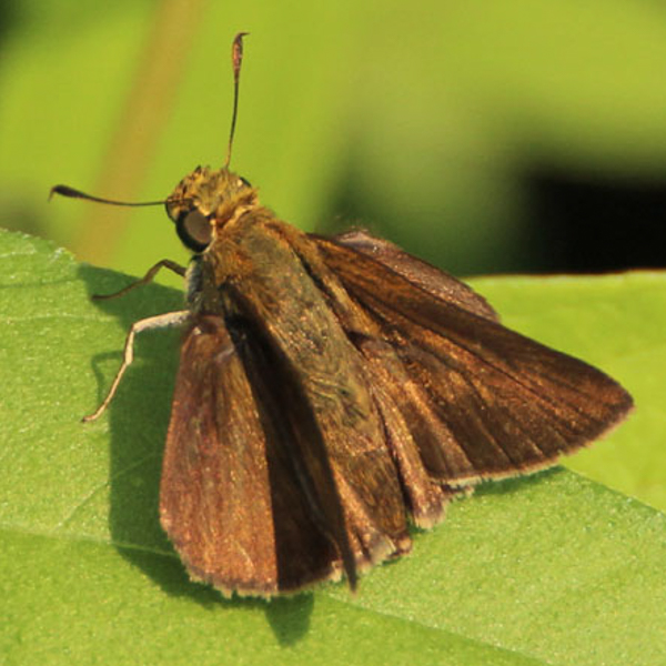
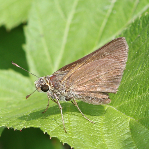
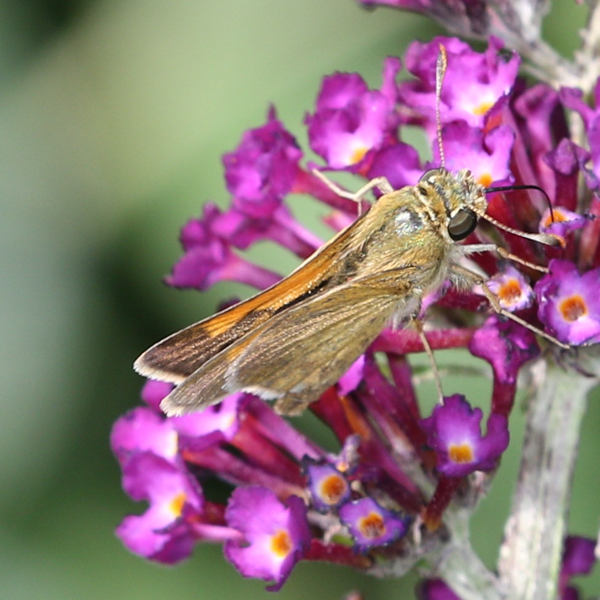
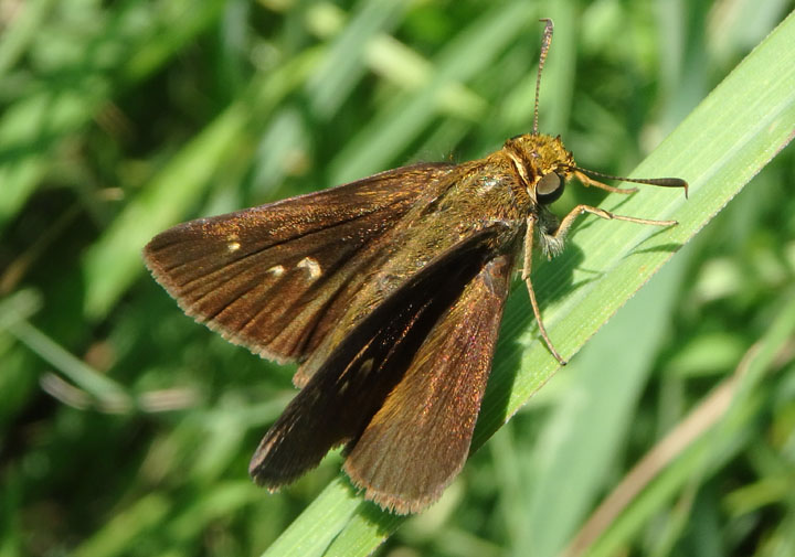
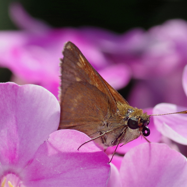
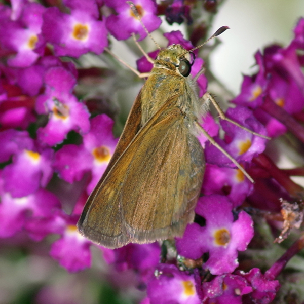
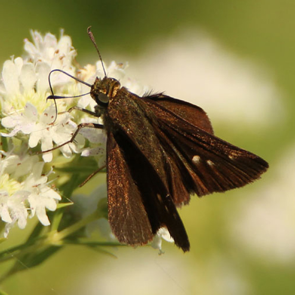
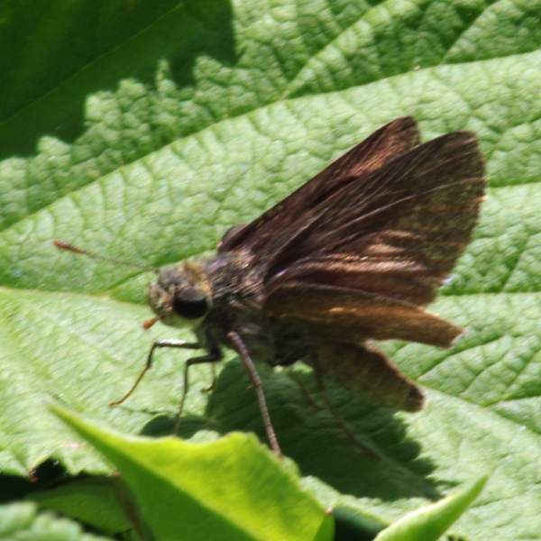
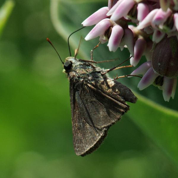
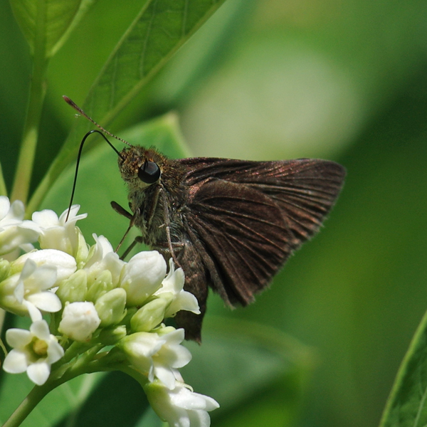
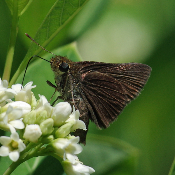
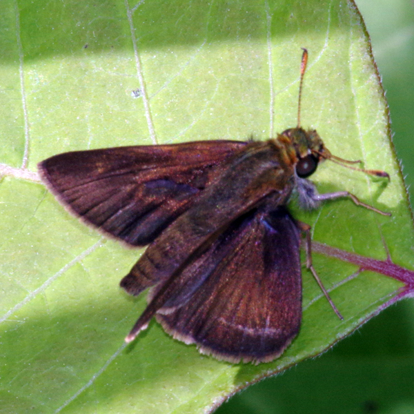
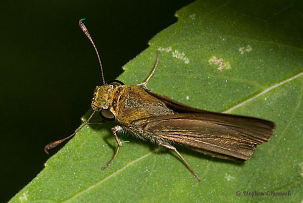
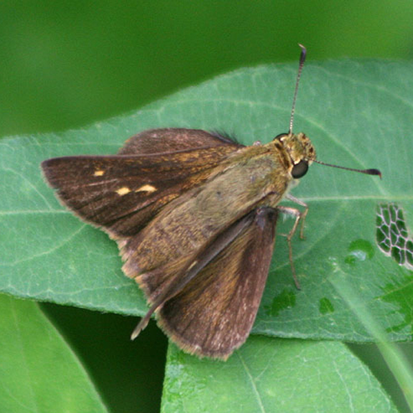
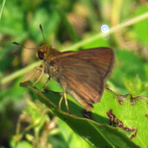
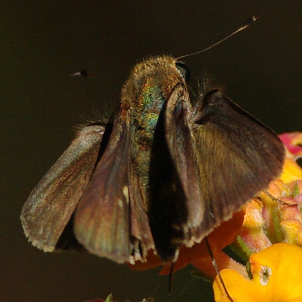
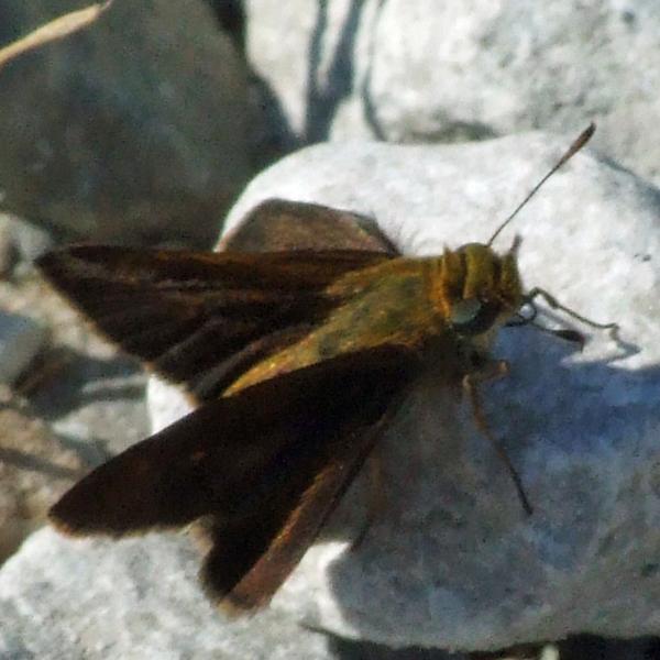
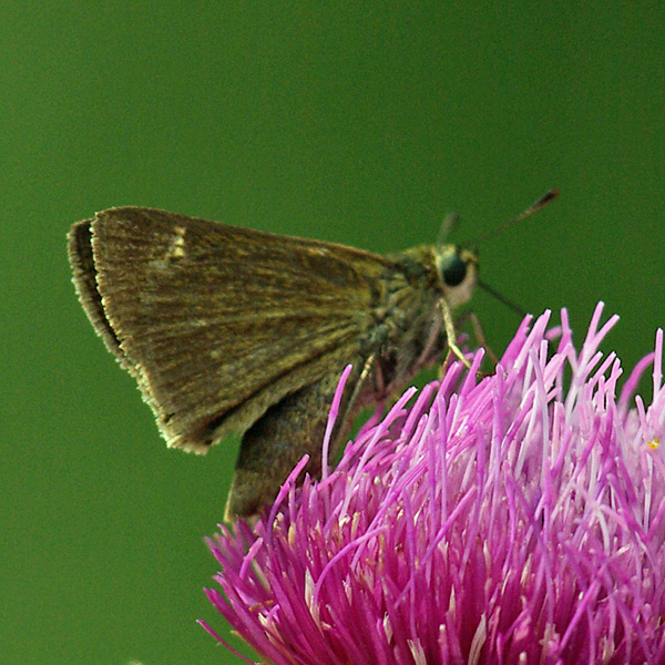
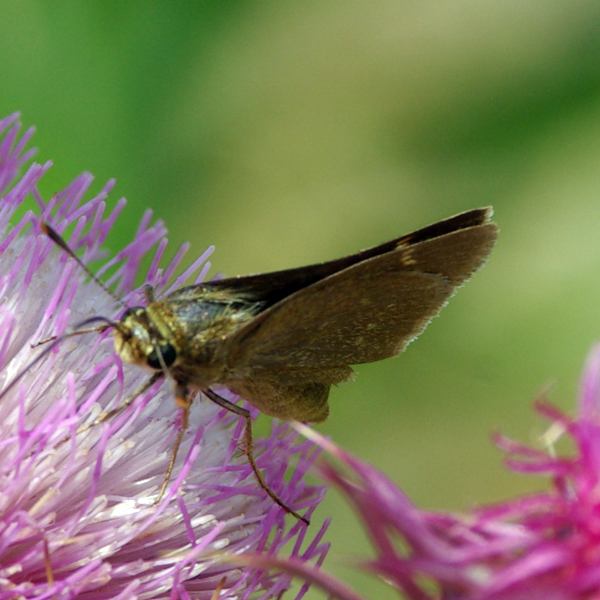
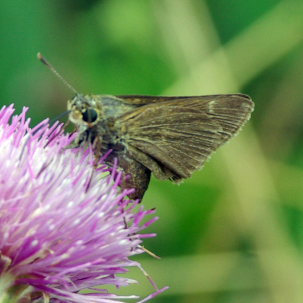
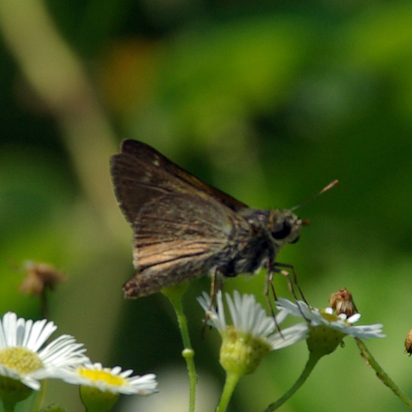
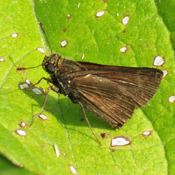
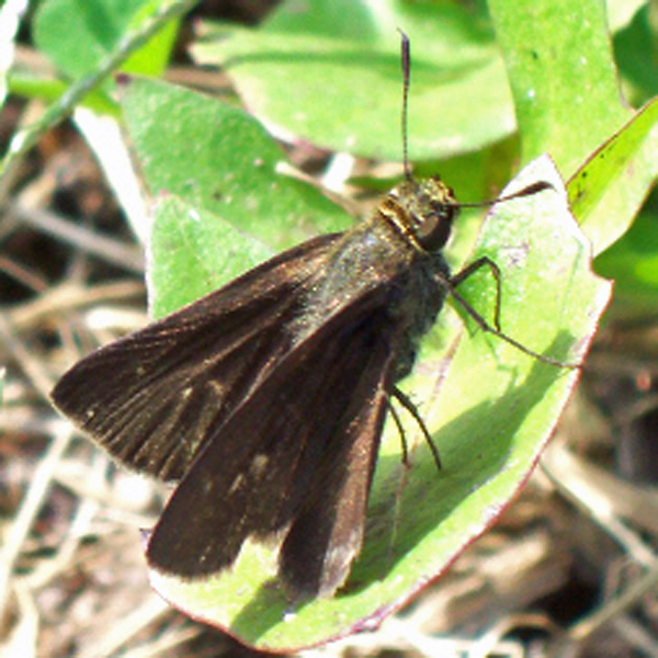
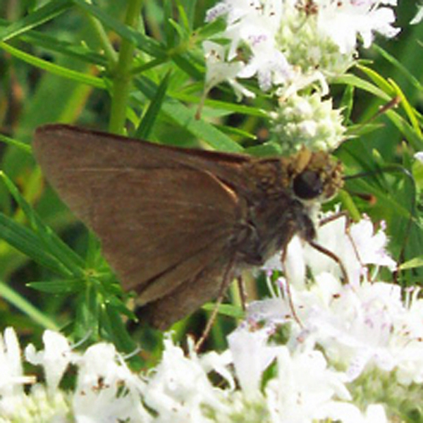
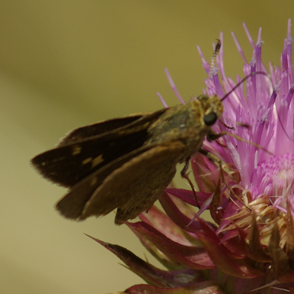
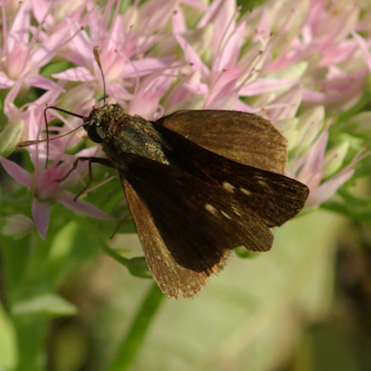
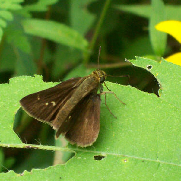
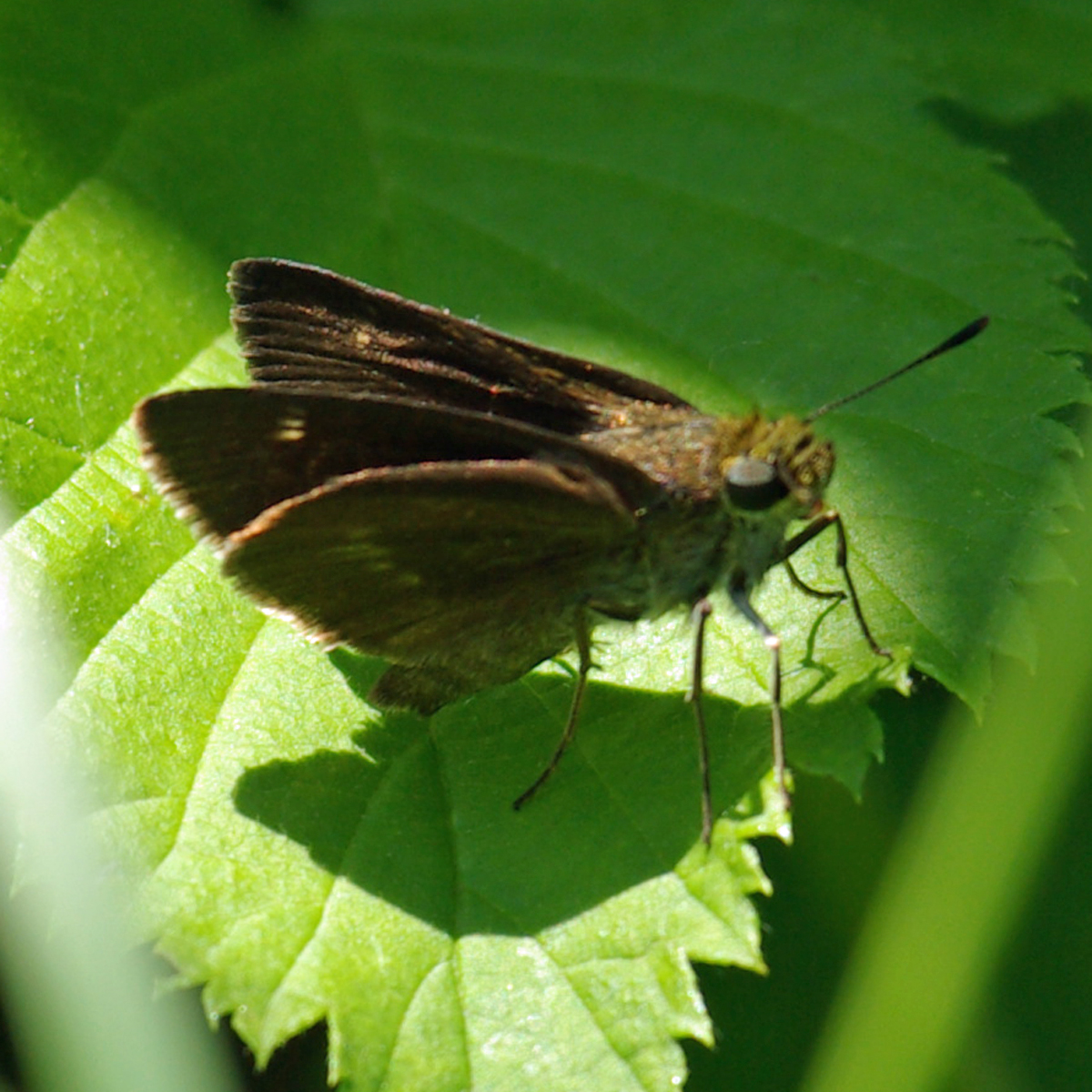
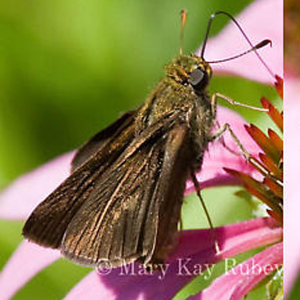
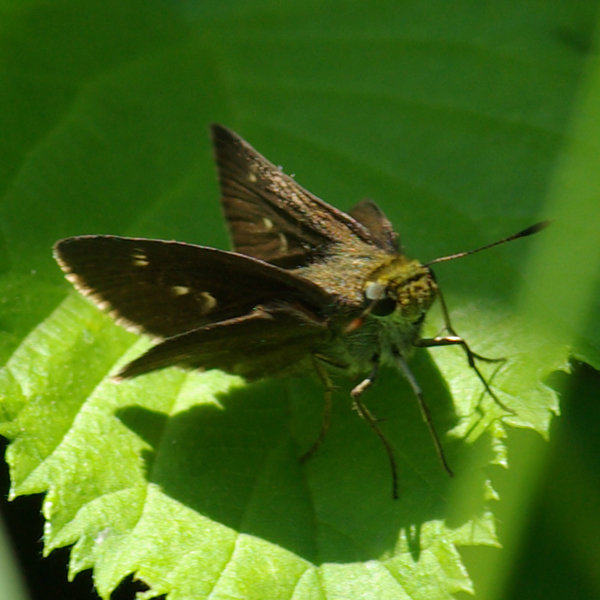
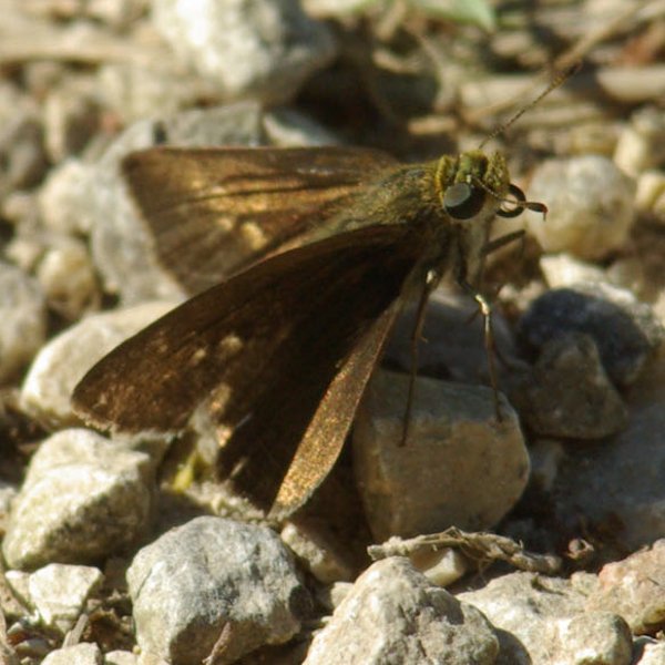
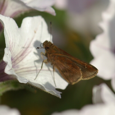
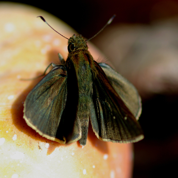
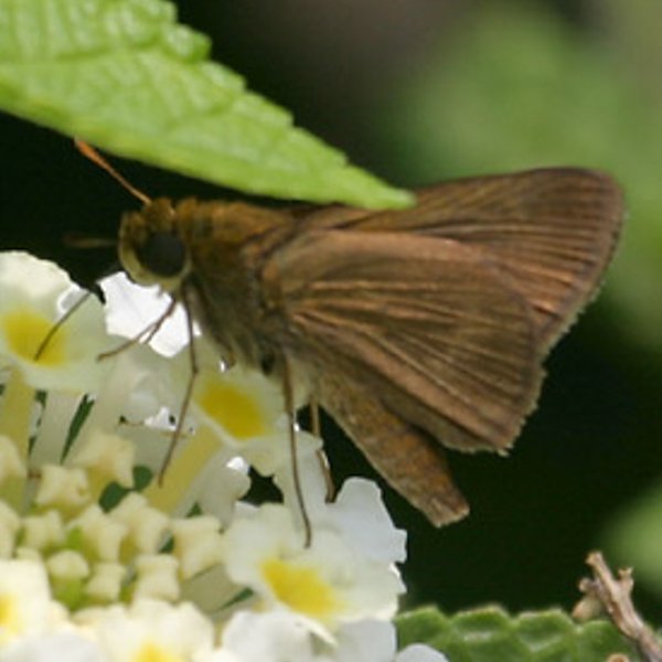
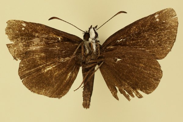
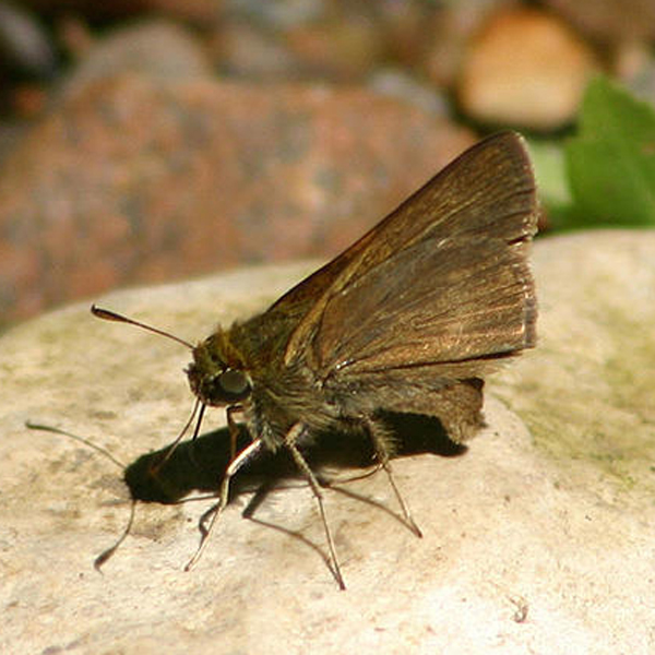
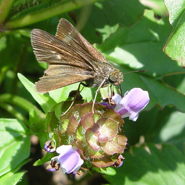
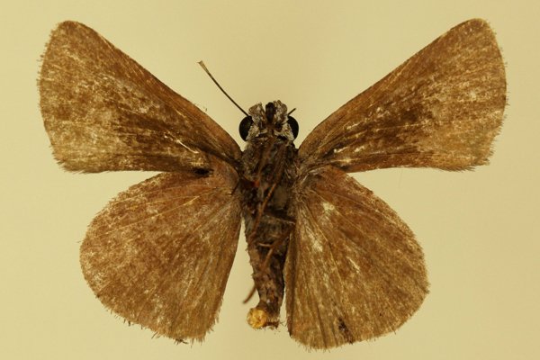
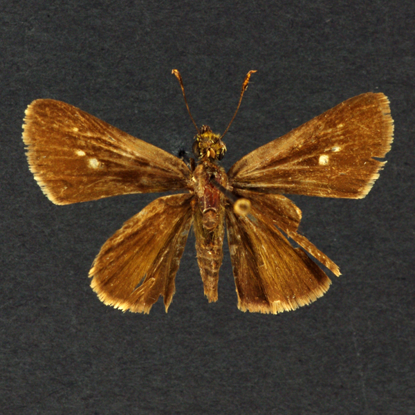
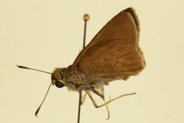
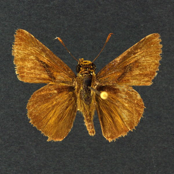
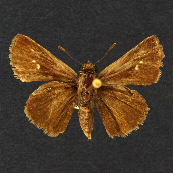
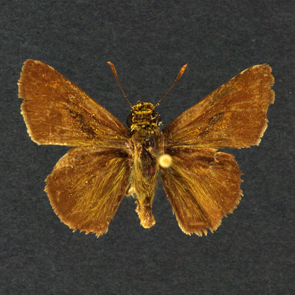
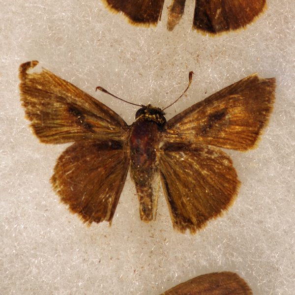
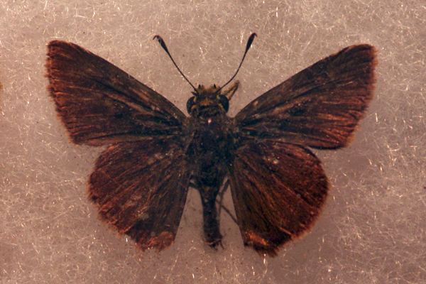
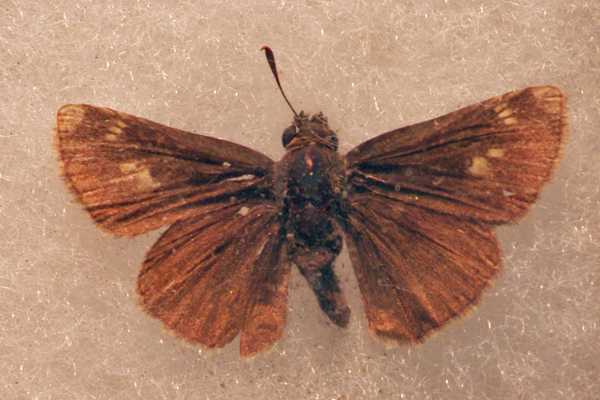
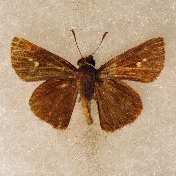
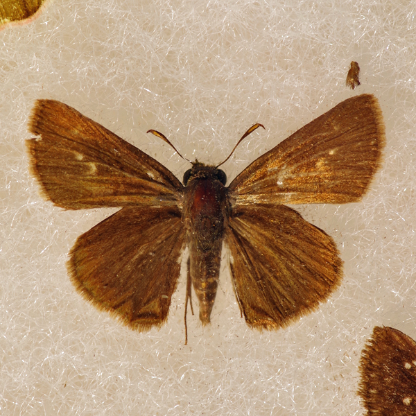
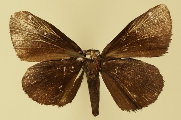
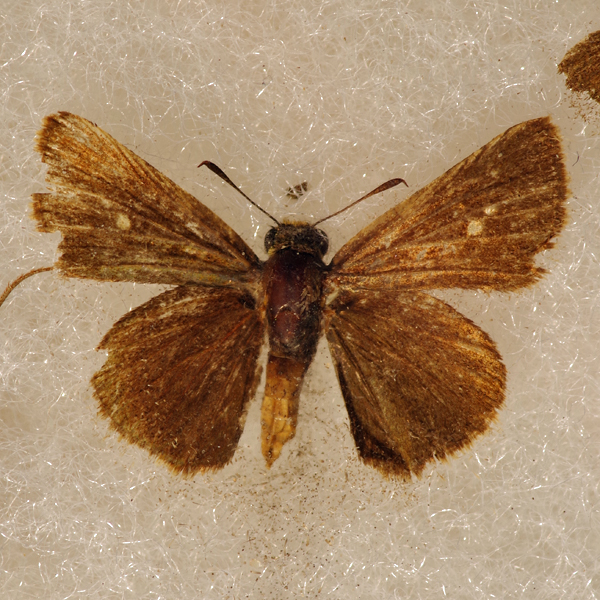
Distinguishing features: This is a uniformly dark brown skipper. Males have a black stigma, and females have a few white spots on the upper forewing. Females often have a faint crescent of light brown spots on the mid-hindwing below. It differs from the Little Glassy Wing and Northern Broken Dash by having reduced light markings (if any) on the upper forewing.
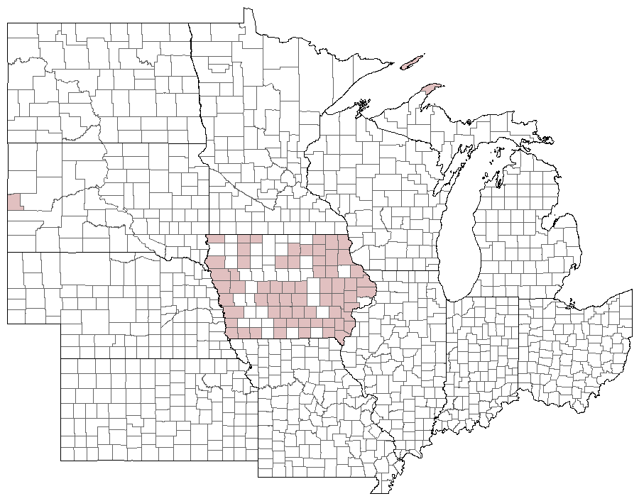
Distribution and habitat: It is common throughout the state in a wide variety of open habitats.
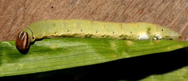
Natural History: The larval hosts are unreported, but are believed to be various members of the sedge family.


| Record # | Date | Locale | State | Lat/Lon | Collected By | Count |
|---|---|---|---|---|---|---|
 346244 346244
|
2023-09-10 | Saylorville Visitor Center | Iowa | 41.710399 -93.67038 | Jay Gilliam | 1 |
 346205 346205
|
2023-08-27 | Folsom Point Preserve | Iowa | 41.154432 -95.799393 | Jay Gilliam | 3 |
| 347063 | 2023-08-20 | Slip Bluff County Park | Iowa | 40.652884 -93.847544 | Jay Gilliam | 3 |
| 347023 | 2023-08-19 | Elk Rock State Park | Iowa | 41.40032 -93.060454 | Jay Gilliam | 1 |
| 347032 | 2023-08-19 | Middle River Park | Iowa | 41.317638 -94.004713 | Jay Gilliam | 3 |
| 347041 | 2023-08-19 | Pammel State Park | Iowa | 41.294986 -94.074903 | Jay Gilliam | 2 |
| 349656 | 2023-08-19 | Cedar River Crossing Conservation Area | IA | 41.836408 -91.40124 | Chris Edwards | 2 |
| 344362 | 2023-08-12 | Turkey Run Access | Iowa | 40.550592 -91.654215 | Frank Olsen | 1 |
| 346972 | 2023-08-12 | Geode State Park | Iowa | 40.816704 -91.388116 | Jay Gilliam | 1 |
| 347014 | 2023-08-12 | Turkey Run Wildlife Area, Lee County | Iowa | 40.557863 -91.680371 | Jay Gilliam | 2 |
 347814 347814
|
2023-08-12 | Saylorville Visitor Center | Iowa | 41.707308266667 -93.671161271667 | Mark Brown | 1 |
 346176 346176
|
2023-08-05 | Folsom Point Preserve | Iowa | 41.154432 -95.799393 | Jay Gilliam | 3 |
 344245 344245
|
2023-07-24 | Rock Island Botanical State Preserve | Iowa | 42.02732 -91.72723 | Frank Olsen | 1 |
| 349760 | 2023-07-15 | Effigy Mounds National Monument | IA | 43.100641 -91.183746 | Chris Edwards | 7 |
 336870 336870
|
2023-07-06 | Wildcat Bluff Recreational Area | Iowa | 42.19331874 -91.88041838 | Jim Durbin | 1 |
 336872 336872
|
2023-07-06 | Wildcat Bluff Recreational Area | Iowa | 42.19331874 -91.88041838 | Jim Durbin | 1 |
 336905 336905
|
2023-07-06 | Wildcat Bluff Recreational Area | Iowa | 42.19331874 -91.88041838 | Jim Durbin | 1 |
 343584 343584
|
2023-07-04 | Ciha Fen Wildlife Preserve | Iowa | 41.829264615 -91.382295668333 | Mark Brown | 1 |
 343171 343171
|
2023-06-25 | Turkey Run Wildlife Area, Lee County | Iowa | 40.558681 -91.682163 | Mark Brown | 1 |
| 349952 | 2023-06-25 | Lee County | IA | 40.706317 -91.443757 | Chris Edwards | 6 |
| 350116 | 2023-06-25 | Shimek State Forest, Croton Unit East | IA | 40.545896 -91.616881 | Chris Edwards | 4 |
| 350172 | 2023-06-25 | Shimek State Forest, Donnellson Unit | IA | 40.643603 -91.67741 | Chris Edwards | 5 |
| 350193 | 2023-06-25 | Shimek State Forest, Lick Creek Unit | IA | 40.61233 -91.685905 | Chris Edwards | 2 |
| 350293 | 2023-06-25 | Turkey Run Wildlife Area, Lee County | IA | 40.558402 -91.679173 | Chris Edwards | 2 |
| 346642 | 2023-06-24 | Shimek State Forest, Donnellson Unit | Iowa | 40.637967 -91.666815 | Jay Gilliam | 3 |
| 346600 | 2023-06-18 | Springbrook State Park | Iowa | 41.775766 -94.464659 | Jay Gilliam | 1 |
| 346514 | 2023-06-14 | Chichaqua Bottoms- Clingan Grassland Unit | Iowa | 41.777616 -93.355846 | Jay Gilliam | 4 |
| 346499 | 2023-06-10 | Slip Bluff County Park | Iowa | 40.652884 -93.847544 | Jay Gilliam | 7 |
 342411 342411
|
2023-05-28 | Rolling Thunder Prairie State Preserve | Iowa | 41.199808908333 -93.655166968333 | Mark Brown | 1 |
| 327837 | 2022-09-13 | Easter Lake | Iowa | 41.545422 -93.56662 | IBSN | 2 |
| 327843 | 2022-09-08 | Rochester Cemetery | Iowa | 41.664504 -91.137696 | IBSN | 3 |
| 317030 | 2022-09-07 | Rand Park, Keokuk | Iowa | 40.4105556 -91.3811111 | Frank Olsen | 1 |
| 327835 | 2022-09-04 | Easter Lake | Iowa | 41.545422 -93.56662 | IBSN | 1 |
| 318512 | 2022-09-03 | Five Ridge Prairie State Preserve | Iowa | 42.679143 -96.523488 | Jay Gilliam | 1 |
| 327834 | 2022-09-03 | Easter Lake | Iowa | 41.545422 -93.56662 | IBSN | 1 |
| 327836 | 2022-08-31 | Easter Lake | Iowa | 41.545422 -93.56662 | IBSN | 2 |
| 327833 | 2022-08-30 | Easter Lake | Iowa | 41.545422 -93.56662 | IBSN | 2 |
| 318490 | 2022-08-28 | Elk Rock State Park | Iowa | 41.39775 -93.090603 | Jay Gilliam | 1 |
| 318501 | 2022-08-28 | Elk Rock State Park | Iowa | 41.40032 -93.060454 | Jay Gilliam | 1 |
 318462 318462
|
2022-08-27 | Loess Hills Scenic Overlook | Iowa | 41.905198 -95.945582 | Jay Gilliam | 2 |
| 327841 | 2022-08-26 | Port Louisa National Wildlife Refuge | Iowa | 41.239649 -91.124611 | IBSN | 1 |
 333183 333183
|
2022-08-21 | Lake MacBride State Park | Iowa | 41.80026274666667 -91.57121668166667 | Mark Brown | 1 |
| 331638 | 2022-08-21 | Heron Bend Conservation Area | Iowa | 40.572222 -91.424444 | Chris Edwards | 1 |
| 331651 | 2022-08-21 | Rand Park, Keokuk | Iowa | 40.410932 -91.381383 | Chris Edwards | 6 |
| 331679 | 2022-08-21 | Shimek State Forest, Croton Unit East | Iowa | 40.545896 -91.616881 | Chris Edwards | 11 |
| 331702 | 2022-08-21 | Turkey Run Access | Iowa | 40.550644 -91.654633 | Chris Edwards | 3 |
| 331722 | 2022-08-21 | Turkey Run Wildlife Area, Lee County | Iowa | 40.558402 -91.679173 | Chris Edwards | 2 |
| 331603 | 2022-08-17 | Lake MacBride State Park | Iowa | 41.791057 -91.547646 | Chris Edwards | 8 |
| 318404 | 2022-08-14 | Slip Bluff County Park | Iowa | 40.652884 -93.847544 | Jay Gilliam | 4 |
| 318311 | 2022-08-06 | Shimek State Forest, Croton Unit East | Iowa | 40.546129 -91.616172 | Jay Gilliam | 1 |
 312758 312758
|
2022-07-26 | 1460 Douglas Ct, Marion | Iowa | 42.040069 -91.590953 | Jim Durbin | 1 |
| 318279 | 2022-07-24 | Coyote Canyon Wildlife Area | Iowa | 41.099428 -93.858554 | Jay Gilliam | 3 |
| 318177 | 2022-07-09 | Effigy Mounds National Monument | Iowa | 43.101383 -91.187278 | Jay Gilliam | 1 |
| 327840 | 2022-07-09 | Matsell Bridge Natural Area | Iowa | 42.11759 -91.384618 | IBSN | 1 |
| 331411 | 2022-07-09 | Effigy Mounds National Monument | Iowa | 43.100641 -91.183746 | Chris Edwards | 3 |
| 331448 | 2022-07-09 | Yellow River State Forest | Iowa | 43.166015 -91.233583 | Chris Edwards | 3 |
 316360 316360
|
2022-07-02 | Ciha Fen Wildlife Preserve | Iowa | 41.82929959 -91.38152937 | Mark Brown | 1 |
| 317442 | 2022-06-27 | Wickiup Hill Outdoor Learning Area | Iowa | 42.08398 -91.7651 | Frank Olsen | 1 |
| 318069 | 2022-06-26 | Rolling Thunder Prairie State Preserve | Iowa | 41.204306 -93.656457 | Jay Gilliam | 2 |
| 327839 | 2022-06-23 | Jester Park | Iowa | 41.786297 -93.788656 | IBSN | 1 |
| 317076 | 2022-06-22 | Rock Island Botanical State Preserve | Iowa | 42.02732 -91.72723 | Frank Olsen | 1 |
| 331356 | 2022-06-20 | Ciha Fen Wildlife Preserve | Iowa | 41.830403 -91.381607 | Chris Edwards | 1 |
 317953 317953
|
2022-06-18 | Folsom Point Preserve | Iowa | 41.154432 -95.799393 | Jay Gilliam | 6 |
| 327838 | 2022-06-18 | Jennett Heritage Area | Iowa | 41.950832 -93.456793 | IBSN | 2 |
| 331241 | 2022-06-18 | Lee County | Iowa | 40.706886 -91.443349 | Chris Edwards | 9 |
| 331273 | 2022-06-18 | Shimek State Forest, Croton Unit East | Iowa | 40.545896 -91.616881 | Chris Edwards | 31 |
| 331301 | 2022-06-18 | Shimek State Forest, Donnellson Unit | Iowa | 40.643603 -91.67741 | Chris Edwards | 13 |
| 331316 | 2022-06-18 | Shimek State Forest, Lick Creek Unit | Iowa | 40.61233 -91.685905 | Chris Edwards | 4 |
| 331340 | 2022-06-18 | Turkey Run Wildlife Area, Lee County | Iowa | 40.558402 -91.679173 | Chris Edwards | 5 |
| 327842 | 2022-06-16 | Red Feather Prairie | Iowa | 41.7205866 -93.669776 | IBSN | 1 |
| 317862 | 2022-06-04 | Stephens State Forest - Thousand Acre Unit, Monroe County | Iowa | 41.117567 -93.086683 | Jay Gilliam | 1 |
| 316668 | 2022-06-03 | Heron Bend Conservation Area | Iowa | 40.5722222 -91.4244444 | Frank Olsen | 1 |
| 304277 | 2021-09-27 | Easter Lake | Iowa | 41.545422 -93.56662 | IBSN | 1 |
| 301078 | 2021-09-12 | Cordova Park | Iowa | 41.42552 -93.089529 | Jay Gilliam | 1 |
| 297018 | 2021-09-05 | Heron Bend Conservation Area | Iowa | 40.5711 -91.4215 | Frank Olsen | 1 |
| 297114 | 2021-09-05 | Shimek State Forest, Lick Creek Unit | Iowa | 40.62032 -91.69603 | Frank Olsen | 1 |
| 308638 | 2021-08-30 | Heron Bend Conservation Area | Iowa | 40.572222 -91.424444 | Chris Edwards | 1 |
| 308664 | 2021-08-30 | Shimek State Forest, Croton Unit East | Iowa | 40.545896 -91.616881 | Chris Edwards | 5 |
| 308694 | 2021-08-30 | Turkey Run Wildlife Area, Lee County | Iowa | 40.558402 -91.679173 | Chris Edwards | 1 |
| 301018 | 2021-08-22 | Middle River Park | Iowa | 41.317638 -94.004713 | Jay Gilliam | 1 |
| 300992 | 2021-08-21 | Wilcox Wildlife Area | Iowa | 41.238081 -92.956863 | Jay Gilliam | 1 |
| 300974 | 2021-08-15 | Beaver Creek- NW 70th access | Iowa | 41.687253 -93.73496 | Jay Gilliam | 1 |
 300908 300908
|
2021-08-08 | Middle River Park | Iowa | 41.317638 -94.004713 | Jay Gilliam | 1 |
| 300918 | 2021-08-08 | Pammel State Park | Iowa | 41.294986 -94.074903 | Jay Gilliam | 3 |
 300894 300894
|
2021-08-07 | Slip Bluff County Park | Iowa | 40.652884 -93.847544 | Jay Gilliam | 1 |
| 297085 | 2021-08-04 | Shimek State Forest, Donnellson Unit | Iowa | 40.650393 -91.686757 | Frank Olsen | 1 |
| 300810 | 2021-07-25 | Stephens State Forest- Mine Pond | Iowa | 41.016084 -93.479874 | Jay Gilliam | 1 |
| 308354 | 2021-07-19 | Shimek State Forest, Croton Unit East | Iowa | 40.545896 -91.616881 | Chris Edwards | 8 |
| 308383 | 2021-07-19 | Shimek State Forest, Lick Creek Unit | Iowa | 40.61233 -91.685905 | Chris Edwards | 1 |
| 308414 | 2021-07-19 | Turkey Run Wildlife Area, Lee County | Iowa | 40.558402 -91.679173 | Chris Edwards | 6 |
 295292 295292
|
2021-07-17 | Effigy Mounds National Monument | Iowa | 43.08725518 -91.18881336 | Mark Brown | 1 |
| 308264 | 2021-07-17 | Effigy Mounds National Monument | Iowa | 43.100641 -91.183746 | Chris Edwards | 3 |
| 304280 | 2021-07-04 | Port Louisa National Wildlife Refuge, Horseshoe Bend | Iowa | 41.119631 -91.115408 | IBSN | 1 |
 295426 295426
|
2021-07-03 | Fayette County, Iowa | Iowa | Location Protected | Mark Brown | 1 |
| 297321 | 2021-07-01 | Hitaga Sand Ridge Prairie Preserve | Iowa | 42.25052 -91.63543 | Frank Olsen | 1 |
| 304278 | 2021-06-28 | Cedar View Trail | Iowa | 40.990459 -92.005459 | IBSN | 2 |
 295593 295593
|
2021-06-27 | Rolling Thunder Prairie State Preserve | Iowa | 41.19979007 -93.65491484 | Mark Brown | 1 |
| 307988 | 2021-06-19 | Lee County | Iowa | 0 0 | Chris Edwards | 2 |
| 308010 | 2021-06-19 | Shimek State Forest, Croton Unit East | Iowa | 40.545896 -91.616881 | Chris Edwards | 8 |
| 308034 | 2021-06-19 | Shimek State Forest, Donnellson Unit | Iowa | 40.643603 -91.67741 | Chris Edwards | 5 |
| 308052 | 2021-06-19 | Shimek State Forest, Lick Creek Unit | Iowa | 40.61233 -91.685905 | Chris Edwards | 2 |
| 308062 | 2021-06-19 | Turkey Run Access | Iowa | 40.550644 -91.654633 | Chris Edwards | 5 |
| 308079 | 2021-06-19 | Turkey Run Wildlife Area, Lee County | Iowa | 40.558402 -91.679173 | Chris Edwards | 2 |
 300574 300574
|
2021-06-18 | Rolling Thunder Prairie State Preserve | Iowa | 41.204306 -93.656457 | Jay Gilliam | 12 |
| 304281 | 2021-06-16 | Port Louisa National Wildlife Refuge | Iowa | 41.239649 -91.124611 | IBSN | 1 |
| 304279 | 2021-06-14 | Jefferson County Park | Iowa | 40.989906 -91.990814 | IBSN | 11 |
| 300457 | 2021-06-05 | Slip Bluff County Park | Iowa | 40.652884 -93.847544 | Jay Gilliam | 1 |
 300468 300468
|
2021-06-05 | Decatur Wildlife Management Area | Iowa | 40.831388 -93.856857 | Jay Gilliam | 3 |
| 307821 | 2021-06-04 | Shimek State Forest, Croton Unit East | Iowa | 40.545896 -91.616881 | Chris Edwards | 1 |
| 307854 | 2021-06-04 | Turkey Run Wildlife Area, Lee County | Iowa | 40.558402 -91.679173 | Chris Edwards | 1 |
 300431 300431
|
2021-05-31 | Stephens State Forest - Thousand Acre Unit, Monroe County | Iowa | 41.118772 -93.095614 | Jay Gilliam | 1 |
| 281008 | 2020-09-04 | Heron Bend Conservation Area | Iowa | 40.572222 -91.424444 | Chris Edwards | 1 |
| 281009 | 2020-09-04 | Rand Park, Keokuk | Iowa | 40.410932 -91.381383 | Chris Edwards | 10 |
| 281010 | 2020-09-04 | Shimek State Forest, Croton Unit East | Iowa | 40.545896 -91.616881 | Chris Edwards | 34 |
| 281011 | 2020-09-04 | Turkey Run Access | Iowa | 40.550644 -91.654633 | Chris Edwards | 3 |
| 281012 | 2020-09-04 | Turkey Run Wildlife Area, Lee County | Iowa | 40.558402 -91.679173 | Chris Edwards | 16 |
| 273910 | 2020-08-30 | Rand Park, Keokuk | Iowa | 40.4105556 -91.3811111 | Frank Olsen | 3 |
| 274277 | 2020-08-30 | Shimek State Forest, Lick Creek Unit | Iowa | 40.618388 -91.680338 | Frank Olsen | 3 |
| 274444 | 2020-08-30 | Turkey Run Wildlife Area, Lee County | Iowa | 40.556414 -91.678161 | Frank Olsen | 4 |
| 281002 | 2020-08-23 | Heron Bend Conservation Area | Iowa | 40.572222 -91.424444 | Chris Edwards | 8 |
| 281003 | 2020-08-23 | Rand Park, Keokuk | Iowa | 40.410932 -91.381383 | Chris Edwards | 17 |
| 281004 | 2020-08-23 | Shimek State Forest, Croton Unit East | Iowa | 40.545896 -91.616881 | Chris Edwards | 18 |
| 281005 | 2020-08-23 | Shimek State Forest, Donnellson Unit | Iowa | 40.643603 -91.67741 | Chris Edwards | 2 |
| 281006 | 2020-08-23 | Turkey Run Access | Iowa | 40.550644 -91.654633 | Chris Edwards | 2 |
| 281007 | 2020-08-23 | Turkey Run Wildlife Area, Lee County | Iowa | 40.558402 -91.679173 | Chris Edwards | 10 |
 276235 276235
|
2020-08-22 | Slip Bluff County Park | Iowa | 40.652884 -93.847544 | Jay Gilliam | 1 |
| 274474 | 2020-08-21 | Waubonsie State Park | Iowa | 40.676 -95.689 | Frank Olsen | 1 |
 272490 272490
|
2020-08-15 | Ciha Fen Wildlife Preserve | Iowa | 41.82923463 -91.38194598 | Mark Brown | 1 |
 282282 282282
|
2020-08-15 | Ciha Fen Wildlife Preserve | Iowa | 41.829513 -91.381134 | Mark Brown | 1 |
 276208 276208
|
2020-08-08 | Eddyville Sand Prairie Park | Iowa | 41.154568 -92.618726 | Jay Gilliam | 1 |
| 281001 | 2020-08-08 | Ciha Fen Wildlife Preserve | Iowa | 41.830403 -91.381607 | Chris Edwards | 3 |
| 280998 | 2020-08-04 | Heron Bend Conservation Area | Iowa | 40.572222 -91.424444 | Chris Edwards | 2 |
| 280999 | 2020-08-04 | Shimek State Forest, Croton Unit East | Iowa | 40.545896 -91.616881 | Chris Edwards | 6 |
| 281000 | 2020-08-04 | Turkey Run Access | Iowa | 40.550644 -91.654633 | Chris Edwards | 2 |
| 274096 | 2020-08-01 | Shimek State Forest, Croton Unit East | Iowa | 40.545472 -91.616246 | Frank Olsen | 1 |
| 276096 | 2020-07-28 | Decatur Wildlife Management Area | Iowa | 40.831388 -93.856857 | Jay Gilliam | 1 |
| 280996 | 2020-07-12 | Effigy Mounds National Monument | Iowa | 43.100641 -91.183746 | Chris Edwards | 1 |
| 280997 | 2020-07-12 | Yellow River State Forest | Iowa | 43.170603 -91.240395 | Chris Edwards | 1 |
| 284393 | 2020-07-12 | Cedar View Trail | Iowa | 40.990996 -92.004793 | IBSN | 3 |
| 284392 | 2020-07-09 | Terry Trueblood Recreation Area | Iowa | 41.625564 -91.528019 | IBSN | 2 |
| 273379 | 2020-07-05 | Hitaga Sand Ridge Prairie Preserve | Iowa | 42.25088 -91.632179 | Frank Olsen | 1 |
| 280995 | 2020-07-02 | Medora Prairie | Iowa | 41.207159 -93.626469 | Chris Edwards | 1 |
| 280993 | 2020-06-25 | Volga River SRA-I Avenue Prairie | Iowa | 42.889998 -91.767305 | Chris Edwards | 1 |
| 280994 | 2020-06-25 | Volga River State Recreation Area | Iowa | 42.879947 -91.786971 | Chris Edwards | 1 |
 275752 275752
|
2020-06-23 | Decatur Wildlife Management Area | Iowa | 40.831388 -93.856857 | Jay Gilliam | 1 |
 275780 275780
|
2020-06-23 | Slip Bluff County Park | Iowa | 40.652884 -93.847544 | Jay Gilliam | 1 |
| 284391 | 2020-06-23 | Indian Creek Nature Center | Iowa | 41.966565 -91.588255 | IBSN | 7 |
| 280989 | 2020-06-21 | Lee County | Iowa | 0 0 | Chris Edwards | 3 |
| 280990 | 2020-06-21 | Shimek State Forest, Croton Unit East | Iowa | 40.545896 -91.616881 | Chris Edwards | 47 |
| 280991 | 2020-06-21 | Shimek State Forest, Donnellson Unit | Iowa | 40.643603 -91.67741 | Chris Edwards | 16 |
| 280992 | 2020-06-21 | Turkey Run Wildlife Area, Lee County | Iowa | 40.558402 -91.679173 | Chris Edwards | 6 |
| 284389 | 2020-06-21 | Cedar View Trail | Iowa | 40.990996 -92.004793 | IBSN | 22 |
| 284390 | 2020-06-21 | Jefferson County Park | Iowa | 40.990015 -91.986398 | IBSN | 1 |
| 274075 | 2020-06-16 | Shimek State Forest, Croton Unit East | Iowa | 40.545472 -91.616246 | Frank Olsen | 6 |
| 274160 | 2020-06-16 | Shimek State Forest, Donnellson Unit | Iowa | 40.64741 -91.686584 | Frank Olsen | 2 |
| 274244 | 2020-06-16 | Shimek State Forest, Lick Creek Unit | Iowa | 40.618388 -91.680338 | Frank Olsen | 1 |
| 274394 | 2020-06-16 | Turkey Run Wildlife Area, Lee County | Iowa | 40.556414 -91.678161 | Frank Olsen | 4 |
 268525 268525
|
2020-06-13 | Redbird Farms Wildlife Area | Iowa | 41.613652 -91.709888 | Mark Brown | 1 |
| 280986 | 2020-06-12 | Stephens State Forest - Cedar Creek Unit | Iowa | 41.059929 -93.177264 | Chris Edwards | 5 |
| 280987 | 2020-06-12 | Stephens State Forest - Thousand Acre Unit, Lucas County | Iowa | 41.087747 -93.109452 | Chris Edwards | 17 |
| 280988 | 2020-06-12 | Stephens State Forest - Thousand Acre Unit, Monroe County | Iowa | 41.116876 -93.084842 | Chris Edwards | 12 |
| 284388 | 2020-06-12 | Cedar View Trail | Iowa | 40.990996 -92.004793 | IBSN | 5 |
 275258 275258
|
2020-06-11 | Eddyville Sand Prairie Park | Iowa | 41.154568 -92.618726 | Jay Gilliam | 3 |
| 280982 | 2020-06-08 | Shimek State Forest, Croton Unit East | Iowa | 40.545896 -91.616881 | Chris Edwards | 11 |
| 280983 | 2020-06-08 | Shimek State Forest, Croton Unit West | Iowa | 40.566286 -91.658401 | Chris Edwards | 1 |
| 280984 | 2020-06-08 | Shimek State Forest, Donnellson Unit | Iowa | 40.643603 -91.67741 | Chris Edwards | 4 |
| 280985 | 2020-06-08 | Turkey Run Wildlife Area, Lee County | Iowa | 40.558402 -91.679173 | Chris Edwards | 1 |
 275580 275580
|
2019-09-23 | Saylorville Visitor Center | Iowa | 41.710399 -93.67038 | Jay Gilliam | 1 |
 275546 275546
|
2019-09-16 | Slip Bluff County Park | Iowa | 40.652884 -93.847544 | Jay Gilliam | 1 |
| 241082 | 2019-09-10 | Shimek State Forest, Lick Creek Unit | Iowa | 40.618675 -91.680702 | Frank Olsen | 1 |
| 241095 | 2019-09-10 | Shimek State Forest, Donnellson Unit | Iowa | 40.649586 -91.68705 | Frank Olsen | 1 |
| 241121 | 2019-09-10 | Turkey Run Wildlife Area, Lee County | Iowa | 40.558402 -91.679173 | Frank Olsen | 1 |
 247323 247323
|
2019-09-01 | Saylorville Visitor Center | Iowa | 41.707983 -93.671168 | Mark Brown | 1 |
 238389 238389
|
2019-09-01 | Cottonwood Recreation Area | Iowa | 41.694164 -93.67387 | Mark Brown | 1 |
 238428 238428
|
2019-09-01 | Saylorville Visitor Center | Iowa | 41.707482 -93.671472 | Mark Brown | 1 |
| 240919 | 2019-08-24 | Sunnycrest Prairie, Dubuque | Iowa | 42.531892 -90.656191 | Frank Olsen | 1 |
| 254969 | 2019-08-22 | Cedar View Trail | Iowa | 40.990459 -92.005459 | IBSN | 1 |
| 249017 | 2019-08-04 | Ciha Fen Wildlife Preserve | Iowa | 41.830403 -91.381607 | Chris Edwards | 1 |
| 254970 | 2019-08-03 | Hickory Hill Park | Iowa | 41.672651 -91.506481 | IBSN | 1 |
| 240658 | 2019-07-29 | Shimek State Forest, Donnellson Unit | Iowa | 40.649586 -91.68705 | Frank Olsen | 1 |
| 248957 | 2019-07-22 | MacBride Nature Recreation Area | Iowa | 41.786242 -91.566399 | Chris Edwards | 1 |
| 248860 | 2019-07-13 | Yellow River State Forest | Iowa | 43.170603 -91.240395 | Chris Edwards | 1 |
| 248663 | 2019-06-16 | Shimek State Forest Count Circle | Iowa | 40.588416 -91.686616 | Chris Edwards | 1 |
| 248685 | 2019-06-16 | Shimek State Forest, Croton Unit East | Iowa | 40.545896 -91.616881 | Chris Edwards | 9 |
| 248704 | 2019-06-16 | Shimek State Forest, Croton Unit West | Iowa | 40.566286 -91.658401 | Chris Edwards | 8 |
| 248723 | 2019-06-16 | Shimek State Forest, Donnellson Unit | Iowa | 40.643603 -91.67741 | Chris Edwards | 1 |
| 248753 | 2019-06-16 | Turkey Run Wildlife Area, Lee County | Iowa | 40.558402 -91.679173 | Chris Edwards | 2 |
 220353 220353
|
2018-09-28 | Daviess County, Kentucky | Kentucky | Location Protected | Jim Durbin | 1 |
 225593 225593
|
2018-08-12 | Saylorville Visitor Center | Iowa | 41.707482 -93.671472 | Mark Brown | 1 |
 217126 217126
|
2018-08-03 | Pappy Dickens Preserve | Iowa | 41.675421 -91.512702 | Jim Durbin | 1 |
 217127 217127
|
2018-08-03 | Pappy Dickens Preserve | Iowa | 41.675421 -91.512702 | Jim Durbin | 1 |
 217129 217129
|
2018-08-02 | 1460 Douglas Ct, Marion | Iowa | 42.040069 -91.590953 | Jim Durbin | 1 |
| 254973 | 2018-07-31 | Waukon City Park | Iowa | 43.256741 -91.475375 | IBSN | 1 |
 225468 225468
|
2018-07-07 | Effigy Mounds National Monument | Iowa | 43.100641 -91.183746 | Mark Brown | 1 |
| 228691 | 2018-07-07 | Effigy Mounds National Monument | Iowa | 43.100641 -91.183746 | Chris Edwards | 8 |
| 228739 | 2018-07-07 | Yellow River State Forest | Iowa | 43.170603 -91.240395 | Chris Edwards | 3 |
| 228631 | 2018-06-16 | Shimek State Forest, Croton Unit East | Iowa | 40.545896 -91.616881 | Chris Edwards | 2 |
| 228654 | 2018-06-16 | Shimek State Forest, Donnellson Unit | Iowa | 40.643603 -91.67741 | Chris Edwards | 2 |
| 228545 | 2018-06-03 | Stephens State Forest - Cedar Creek Unit | Iowa | 41.059942 -93.177277 | Chris Edwards | 1 |
| 228576 | 2018-06-03 | Stephens State Forest - Thousand Acre Unit, Monroe County | Iowa | 41.116869 -93.084835 | Chris Edwards | 1 |
| 199774 | 2017-09-19 | Shimek State Forest, Donnellson Unit | Iowa | 40.64833 -91.68666 | Frank Olsen | 1 |
| 202874 | 2017-09-19 | Rand Park, Keokuk | Iowa | 40.410932 -91.381383 | Chris Edwards | 1 |
| 202875 | 2017-09-19 | Turkey Run Wildlife Area, Lee County | Iowa | 40.558402 -91.679173 | Chris Edwards | 1 |
 201482 201482
|
2017-08-23 | 1460 Douglas Ct, Marion | Iowa | 42.040069 -91.590953 | Jim Durbin | 2 |
| 201475 | 2017-08-22 | 1460 Douglas Ct, Marion | Iowa | 42.040069 -91.590953 | Jim Durbin | 2 |
 201860 201860
|
2017-08-18 | Heron Bend Conservation Area | Iowa | 40.5711 -91.4215 | Angella Moorehouse | 1 |
| 199735 | 2017-08-08 | Shimek State Forest, Croton Unit East | Iowa | 40.54714 -91.62054 | Frank Olsen | 1 |
| 199762 | 2017-08-08 | Shimek State Forest, Donnellson Unit | Iowa | 40.64833 -91.68666 | Frank Olsen | 1 |
 195112 195112
|
2017-08-03 | 1460 Douglas Ct, Marion | Iowa | 42.040069 -91.590953 | Jim Durbin | 1 |
 201937 201937
|
2017-08-01 | 1460 Douglas Ct, Marion | Iowa | 42.040069 -91.590953 | Jim Durbin | 1 |
| 254971 | 2017-07-28 | Neal Smith National Wildlife Refuge | Iowa | 41.56153 -93.276552 | IBSN | 2 |
| 202192 | 2017-07-21 | Decatur County, Iowa | Iowa | Location Protected | Sibylla Brown | 1 |
| 193883 | 2017-07-09 | Rolling Thunder Prairie State Preserve | Iowa | 41.2042 -93.656 | Mark Brown | 1 |
| 202871 | 2017-06-24 | Shimek State Forest, Croton Unit East | Iowa | 40.545896 -91.616881 | Chris Edwards | 4 |
| 202872 | 2017-06-24 | Shimek State Forest, Donnellson Unit | Iowa | 40.643603 -91.67741 | Chris Edwards | 2 |
| 202873 | 2017-06-24 | Turkey Run Wildlife Area, Lee County | Iowa | 40.558402 -91.679173 | Chris Edwards | 3 |
| 202191 | 2017-06-12 | Decatur County, Iowa | Iowa | Location Protected | Sibylla Brown | 1 |
| 202870 | 2017-05-26 | Shimek State Forest, Croton Unit East | Iowa | 40.545896 -91.616881 | Chris Edwards | 1 |
| 199747 | 2017-05-25 | Shimek State Forest, Croton Unit East | Iowa | 40.54714 -91.62054 | Frank Olsen | 1 |
| 180825 | 2016-09-01 | Waubonsie State Park | Iowa | 40.676 -95.689 | Frank Olsen | 2 |
| 180839 | 2016-09-01 | Waubonsie State Park | Iowa | 40.676 -95.689 | Frank Olsen | 1 |
| 184177 | 2016-08-21 | Rand Park, Keokuk | Iowa | 40.410932 -91.381383 | Chris Edwards | 1 |
| 184205 | 2016-08-21 | Shimek State Forest, Croton Unit East | Iowa | 40.545896 -91.616881 | Chris Edwards | 7 |
| 184221 | 2016-08-21 | Shimek State Forest, Croton Unit West | Iowa | 40.566286 -91.658401 | Chris Edwards | 3 |
| 184239 | 2016-08-21 | Shimek State Forest, Donnellson Unit | Iowa | 40.643603 -91.67741 | Chris Edwards | 1 |
| 184248 | 2016-08-21 | Turkey Run Access | Iowa | 40.550644 -91.654633 | Chris Edwards | 4 |
| 184272 | 2016-08-21 | Turkey Run Wildlife Area, Lee County | Iowa | 40.558402 -91.679173 | Chris Edwards | 1 |
| 184126 | 2016-08-14 | Hawkeye Willdlife Management Area | Iowa | 41.775104 -91.705532 | Chris Edwards | 1 |
| 174196 | 2016-08-06 | Medora Prairie | Iowa | 41.209512 -93.627408 | Mark Brown | 2 |
 181812 181812
|
2016-07-16 | Lake MacBride State Park | Iowa | 41.802959 -91.570402 | Mark Brown | 1 |
| 183909 | 2016-07-16 | F. W. Kent Park | Iowa | 41.72916 -91.727161 | Chris Edwards | 2 |
| 183991 | 2016-07-16 | MacBride Nature Recreation Area | Iowa | 41.786242 -91.566399 | Chris Edwards | 1 |
 170005 170005
|
2016-06-18 | Decatur County, Iowa | Iowa | Location Protected | Jim Durbin | 1 |
 170006 170006
|
2016-06-18 | Decatur County, Iowa | Iowa | Location Protected | Jim Durbin | 1 |
| 183826 | 2016-06-18 | Shimek State Forest Count Circle | Iowa | 40.588416 -91.686616 | Chris Edwards | 4 |
| 183847 | 2016-06-18 | Shimek State Forest, Croton Unit East | Iowa | 40.545896 -91.616881 | Chris Edwards | 9 |
| 183867 | 2016-06-18 | Shimek State Forest, Donnellson Unit | Iowa | 40.643603 -91.67741 | Chris Edwards | 11 |
 169639 169639
|
2016-06-17 | Decatur County, Iowa | Iowa | Location Protected | Jim Durbin | 1 |
 169647 169647
|
2016-06-17 | Decatur County, Iowa | Iowa | Location Protected | Jim Durbin | 1 |
| 190323 | 2016-06-16 | Port Louisa National Wildlife Refuge | Iowa | 41.239649 -91.124611 | IBSN | 1 |
| 254972 | 2016-06-16 | Port Louisa National Wildlife Refuge, Horseshoe Bend | Iowa | 41.119631 -91.115408 | IBSN | 1 |
| 182138 | 2016-06-14 | Decatur County, Iowa | Iowa | Location Protected | Sibylla Brown | 1 |
| 180414 | 2016-06-07 | Heron Bend Conservation Area | Iowa | 40.5711 -91.4215 | Frank Olsen | 4 |
| 183765 | 2016-05-29 | Shimek State Forest, Croton Unit East | Iowa | 40.545896 -91.616881 | Chris Edwards | 2 |
 186229 186229
|
2015-10-04 | 5031 Old Lyddane Bridge Road | Kentucky | 37.746771 -87.185979 | Jim Durbin | 1 |
 137690 137690
|
2015-10-02 | Burlington | Iowa | 40.792831 -91.096827 | David Berry | 1 |
| 131399 | 2015-08-31 | Waubonsie State Park | Iowa | 40.676 -95.689 | Frank Olsen | 1 |
| 129320 | 2015-08-17 | Big Creek State Park | Iowa | 41.807055 -93.745185 | Mark Brown | 1 |
| 136359 | 2015-08-12 | Decatur County, Iowa | Iowa | Location Protected | Sibylla Brown | 1 |
| 183628 | 2015-07-18 | F. W. Kent Park | Iowa | 41.72916 -91.727161 | Chris Edwards | 2 |
| 131135 | 2015-07-09 | Whispering Pines Hill Prairie | Iowa | 43.427166 -91.287898 | Frank Olsen | 1 |
| 183516 | 2015-06-21 | Shimek State Forest, Croton Unit East | Iowa | 40.545896 -91.616881 | Chris Edwards | 19 |
| 183537 | 2015-06-21 | Shimek State Forest, Donnellson Unit | Iowa | 40.643603 -91.67741 | Chris Edwards | 9 |
| 131289 | 2015-06-18 | Rolling Thunder Prairie State Preserve | Iowa | 41.2042 -93.656 | Frank Olsen | 1 |
| 136358 | 2015-06-16 | Decatur County, Iowa | Iowa | Location Protected | Sibylla Brown | 1 |
 126036 126036
|
2015-06-02 | Shimek State Forest, Croton Unit East | Iowa | 40.54583 -91.61611 | Jim Durbin | 1 |
| 68731 | 2014-09-07 | Shimek State Forest, Croton Unit East | Iowa | 40.54638889 -91.62555556 | Tom Jantscher | 1 |
| 68850 | 2014-09-07 | Chatfield Park, Keokuk | Iowa | 40.44083333 -91.45777778 | Tom Jantscher | 1 |
| 68886 | 2014-09-07 | Rand Park, Keokuk | Iowa | 40.41083333 -91.38 | Tom Jantscher | 1 |
| 68887 | 2014-09-07 | Rand Park, Keokuk | Iowa | 40.41083333 -91.38 | Tom Jantscher | 1 |
| 114692 | 2014-09-07 | Rand Park, Keokuk | Iowa | 40.410932 -91.381383 | Chris Edwards | 3 |
| 114700 | 2014-09-07 | Argyle Road | Iowa | 40.532094 -91.585736 | Chris Edwards | 3 |
| 114713 | 2014-09-07 | Shimek State Forest, Croton Unit East | Iowa | 40.545896 -91.616881 | Chris Edwards | 1 |
| 109940 | 2014-09-03 | Rolling Thunder Prairie State Preserve | Iowa | 41.2042 -93.656 | Frank Olsen | 1 |
| 109959 | 2014-09-01 | Loess Hills Scenic Overlook | Iowa | 41.904962 -95.945821 | Frank Olsen | 2 |
| 109916 | 2014-08-09 | Rolling Thunder Prairie State Preserve | Iowa | 41.2042 -93.656 | Frank Olsen | 1 |
| 109900 | 2014-07-28 | Rolling Thunder Prairie State Preserve | Iowa | 41.2042 -93.656 | Frank Olsen | 1 |
| 109759 | 2014-07-21 | Perkins Prairie State Preserve | Iowa | 41.98583 -94.39889 | Frank Olsen | 1 |
| 142672 | 2014-07-20 | Rochester Cemetery | Iowa | 41.664504 -91.137696 | IBSN | 1 |
| 68472 | 2014-07-19 | MacBride Nature Recreation Area | Iowa | 41.78611111 -91.56083333 | Tom Jantscher | 1 |
| 68473 | 2014-07-19 | MacBride Nature Recreation Area | Iowa | 41.78611111 -91.56083333 | Tom Jantscher | 1 |
| 114783 | 2014-07-19 | MacBride Nature Recreation Area | Iowa | 41.786242 -91.566399 | Chris Edwards | 2 |
| 114712 | 2014-07-03 | Shimek State Forest, Croton Unit East | Iowa | 40.545896 -91.616881 | Chris Edwards | 9 |
| 114805 | 2014-07-03 | Shimek State Forest, Donnellson Unit | Iowa | 40.643603 -91.67741 | Chris Edwards | 7 |
| 140444 | 2014-06-24 | McFarland Park | Iowa | 42.092878 -93.571 | IBSN | 1 |
| 67981 | 2014-06-14 | MacBride Nature Recreation Area | Iowa | 41.787377 -91.560187 | Tom Jantscher | 1 |
| 67982 | 2014-06-14 | MacBride Nature Recreation Area | Iowa | 41.787377 -91.560187 | Tom Jantscher | 1 |
| 67983 | 2014-06-14 | MacBride Nature Recreation Area | Iowa | 41.787377 -91.560187 | Tom Jantscher | 1 |
| 67984 | 2014-06-14 | MacBride Nature Recreation Area | Iowa | 41.787377 -91.560187 | Tom Jantscher | 1 |
| 68051 | 2014-06-14 | MacBride Nature Recreation Area | Iowa | 41.787377 -91.560187 | Tom Jantscher | 1 |
| 136357 | 2014-06-12 | Decatur County, Iowa | Iowa | Location Protected | Sibylla Brown | 1 |
| 55443 | 2013-09-18 | Turkey Run Access | Iowa | 40.550592 -91.654215 | Frank Olsen | 1 |
| 8436 | 2013-09-07 | Rand Park, Keokuk | Iowa | 40.4105556 -91.3811111 | Tom Jantscher | 1 |
| 8440 | 2013-09-07 | Shimek State Forest, Croton Unit East | Iowa | 40.5469444 -91.6147222 | Tom Jantscher | 1 |
| 8441 | 2013-09-07 | Shimek State Forest, Croton Unit East | Iowa | 40.5472222 -91.6208333 | Tom Jantscher | 1 |
| 114691 | 2013-09-07 | Rand Park, Keokuk | Iowa | 40.410932 -91.381383 | Chris Edwards | 1 |
| 114711 | 2013-09-07 | Shimek State Forest, Croton Unit East | Iowa | 40.545896 -91.616881 | Chris Edwards | 18 |
| 55447 | 2013-09-02 | Waubonsie State Park | Iowa | 40.676 -95.689 | Frank Olsen | 21 |
| 8412 | 2013-08-25 | Sedan Bottoms Wildlife Management Area | Iowa | 40.6661111 -92.7813889 | Tom Jantscher | 1 |
| 8413 | 2013-08-25 | Sedan Bottoms Wildlife Management Area | Iowa | 40.6238889 -92.7325 | Tom Jantscher | 1 |
| 8414 | 2013-08-25 | Sedan Bottoms Wildlife Management Area | Iowa | 40.6694444 -92.7575 | Tom Jantscher | 1 |
| 6850 | 2013-08-18 | Decatur County, Iowa | Iowa | Location Protected | Aaron Brees | 1 |
| 139851 | 2013-08-13 | Green Hills Retirement Community | Iowa | 42.001942 -93.647655 | IBSN | 1 |
| 114786 | 2013-07-14 | Lake MacBride State Park | Iowa | 41.791057 -91.547646 | Chris Edwards | 1 |
| 8425 | 2013-07-06 | Waubonsie State Park | Iowa | 40.676 -95.689 | Tom Jantscher | 1 |
| 8439 | 2013-06-22 | Shimek State Forest, Croton Unit East | Iowa | 40.5405556 -91.6127778 | Tom Jantscher | 1 |
| 8443 | 2013-06-22 | Shimek State Forest, Donnellson Unit | Iowa | 40.6452778 -91.6869444 | Tom Jantscher | 1 |
| 8446 | 2013-06-22 | Turkey Run Wildlife Area, Lee County | Iowa | 40.5563889 -91.6777778 | Tom Jantscher | 1 |
| 114710 | 2013-06-22 | Shimek State Forest, Croton Unit East | Iowa | 40.545896 -91.616881 | Chris Edwards | 3 |
| 114718 | 2013-06-22 | Turkey Run Wildlife Area, Lee County | Iowa | 40.558402 -91.679173 | Chris Edwards | 4 |
| 114745 | 2013-06-22 | Shimek State Forest, Donnellson Unit | Iowa | 40.643603 -91.67741 | Chris Edwards | 6 |
| 114735 | 2013-06-08 | Shimek State Forest, Farmington Unit | Iowa | 40.653998 -91.72554 | Chris Edwards | 1 |
| 8426 | 2012-09-09 | Waubonsie State Park | Iowa | 40.676 -95.689 | Tom Jantscher | 1 |
| 8457 | 2012-09-09 | Folsom Point Preserve | Iowa | 41.1536111 -95.8008333 | Tom Jantscher | 1 |
| 8432 | 2012-09-03 | Shimek State Forest, Donnellson Unit | Iowa | 40.6502778 -91.6866667 | Tom Jantscher | 1 |
| 8433 | 2012-09-03 | Near Sandusky | Iowa | 40.4747222 -91.3883333 | Tom Jantscher | 1 |
| 8435 | 2012-09-03 | Rand Park, Keokuk | Iowa | 40.4105556 -91.3811111 | Tom Jantscher | 1 |
| 114690 | 2012-09-03 | Rand Park, Keokuk | Iowa | 40.410932 -91.381383 | Chris Edwards | 5 |
| 114697 | 2012-09-03 | Heron Bend Conservation Area | Iowa | 40.572222 -91.424444 | Chris Edwards | 1 |
| 114744 | 2012-09-03 | Shimek State Forest, Donnellson Unit | Iowa | 40.643603 -91.67741 | Chris Edwards | 5 |
| 139830 | 2012-08-13 | Green Hills Retirement Community | Iowa | 42.001942 -93.647655 | IBSN | 3 |
| 141891 | 2012-08-10 | Reiman Gardens Area, Ames | Iowa | 42.01102 -93.638089 | IBSN | 2 |
| 141901 | 2012-08-10 | Reiman Gardens Area, Ames | Iowa | 42.01102 -93.638089 | IBSN | 2 |
| 141910 | 2012-08-10 | Reiman Gardens Area, Ames | Iowa | 42.01102 -93.638089 | IBSN | 2 |
| 141919 | 2012-08-10 | Reiman Gardens Area, Ames | Iowa | 42.01102 -93.638089 | IBSN | 2 |
| 114797 | 2012-07-15 | Lake MacBride State Park | Iowa | 41.800146 -91.555669 | Chris Edwards | 1 |
| 8411 | 2012-07-07 | Yellow River State Forest | Iowa | 43.1530556 -91.2336111 | Tom Jantscher | 1 |
| 114824 | 2012-07-07 | Yellow River State Forest | Iowa | 43.170603 -91.240395 | Chris Edwards | 2 |
| 114709 | 2012-06-25 | Shimek State Forest, Croton Unit East | Iowa | 40.545896 -91.616881 | Chris Edwards | 9 |
| 114722 | 2012-06-25 | Shimek State Forest, Croton Unit West | Iowa | 40.566286 -91.658401 | Chris Edwards | 4 |
| 114743 | 2012-06-25 | Shimek State Forest, Donnellson Unit | Iowa | 40.643603 -91.67741 | Chris Edwards | 2 |
| 141821 | 2012-06-20 | Reiman Gardens Area, Ames | Iowa | 42.01102 -93.638089 | IBSN | 2 |
| 8456 | 2012-06-17 | Wickiup Hill Outdoor Learning Area | Iowa | 42.083222 -91.764469 | Tom Jantscher | 1 |
| 143214 | 2012-06-17 | Wickiup Hill Outdoor Learning Area | Iowa | 42.087358 -91.767092 | Tom Jantscher | 1 |
| 120372 | 2012-06-12 | Timberhill | Iowa | 40.715921 -93.651635 | Sibylla Brown | 1 |
| 142563 | 2012-06-08 | Rochester Cemetery | Iowa | 41.664504 -91.137696 | IBSN | 1 |
| 8431 | 2012-05-19 | Shimek State Forest, Donnellson Unit | Iowa | 40.6480556 -91.6866667 | Tom Jantscher | 1 |
| 6845 | 2011-08-20 | Decatur County, Iowa | Iowa | Location Protected | Aaron Brees | 3 |
| 6849 | 2011-07-31 | Stephens State Forest - Woodburn Unit | Iowa | 40.965696 -93.6083756 | Aaron Brees | 2 |
 138244 138244
|
2011-07-31 | Ledges State Park | Iowa | 41.9828 -93.8878 | Stephen Cresswell | 1 |
| 8430 | 2011-07-30 | F. W. Kent Park | Iowa | 41.7352778 -91.7225 | Tom Jantscher | 1 |
| 114763 | 2011-07-30 | F. W. Kent Park | Iowa | 41.72916 -91.727161 | Chris Edwards | 2 |
| 8454 | 2011-07-24 | Wickiup Hill Outdoor Learning Area | Iowa | 42.085 -91.7666667 | Tom Jantscher | 1 |
| 8455 | 2011-07-24 | Wickiup Hill Outdoor Learning Area | Iowa | 42.0902778 -91.7666667 | Tom Jantscher | 1 |
| 143146 | 2011-07-24 | Wickiup Hill Outdoor Learning Area | Iowa | 42.087358 -91.767092 | Tom Jantscher | 2 |
 144050 144050
|
2011-07-24 | F. W. Kent Park | Iowa | 41.7352778 -91.7225 | Mark Brown | 1 |
| 6852 | 2011-07-10 | Medora Prairie | Iowa | 41.209512 -93.627408 | Aaron Brees | 1 |
| 8453 | 2011-07-10 | Wickiup Hill Outdoor Learning Area | Iowa | 42.0863889 -91.7677778 | Tom Jantscher | 1 |
| 143126 | 2011-07-10 | Wickiup Hill Outdoor Learning Area | Iowa | 42.087358 -91.767092 | Tom Jantscher | 2 |
| 6847 | 2011-07-09 | Wilkinson Pioneer Park | Iowa | 43.191363 -93.067789 | Aaron Brees | 2 |
| 8424 | 2011-07-09 | Cedar Hills Sand Prairie Preserve | Iowa | 42.5963889 -92.55 | Tom Jantscher | 1 |
| 114708 | 2011-07-04 | Shimek State Forest, Croton Unit East | Iowa | 40.545896 -91.616881 | Chris Edwards | 42 |
| 114717 | 2011-07-04 | Turkey Run Wildlife Area, Lee County | Iowa | 40.558402 -91.679173 | Chris Edwards | 18 |
| 114734 | 2011-07-04 | Shimek State Forest, Farmington Unit | Iowa | 40.653998 -91.72554 | Chris Edwards | 15 |
| 114742 | 2011-07-04 | Shimek State Forest, Donnellson Unit | Iowa | 40.643603 -91.67741 | Chris Edwards | 24 |
| 114804 | 2011-07-04 | Shimek State Forest, Donnellson Unit | Iowa | 40.643603 -91.67741 | Chris Edwards | 4 |
| 8451 | 2011-06-19 | Rock Island Botanical State Preserve | Iowa | 42.0261111 -91.7258333 | Tom Jantscher | 1 |
| 8452 | 2011-06-19 | Wickiup Hill Outdoor Learning Area | Iowa | 42.0872222 -91.7680556 | Tom Jantscher | 1 |
| 143113 | 2011-06-19 | Wickiup Hill Outdoor Learning Area | Iowa | 42.087358 -91.767092 | Tom Jantscher | 1 |
| 114771 | 2011-06-12 | Hawkeye Willdlife Management Area | Iowa | 41.775104 -91.705532 | Chris Edwards | 1 |
 191743 191743
|
2011-06-06 | Shimek State Forest, Farmington Unit | Iowa | 40.6659 -91.73637 | Jim Durbin | 1 |
 232364 232364
|
2010-11-17 | Dauphin Island--Audubon Bird Sanctuary | Alabama | 30.248019 -88.083912 | Jim Durbin | 1 |
| 8434 | 2010-08-15 | Heron Bend Conservation Area | Iowa | 40.5722222 -91.4244444 | Tom Jantscher | 2 |
| 8437 | 2010-08-15 | Shimek State Forest, Croton Unit East | Iowa | 40.5402778 -91.6125 | Tom Jantscher | 2 |
| 8438 | 2010-08-15 | Shimek State Forest, Croton Unit East | Iowa | 40.5458333 -91.6172222 | Tom Jantscher | 1 |
| 8442 | 2010-08-15 | Shimek State Forest, Donnellson Unit | Iowa | 40.6463889 -91.6863889 | Tom Jantscher | 1 |
| 8444 | 2010-08-15 | Turkey Run Access | Iowa | 40.5508333 -91.6555556 | Tom Jantscher | 1 |
| 8445 | 2010-08-15 | Turkey Run Wildlife Area, Lee County | Iowa | 40.5563889 -91.6777778 | Tom Jantscher | 1 |
| 114696 | 2010-08-15 | Heron Bend Conservation Area | Iowa | 40.572222 -91.424444 | Chris Edwards | 2 |
| 114707 | 2010-08-15 | Shimek State Forest, Croton Unit East | Iowa | 40.545896 -91.616881 | Chris Edwards | 3 |
| 114714 | 2010-08-15 | Turkey Run Access | Iowa | 40.550644 -91.654633 | Chris Edwards | 1 |
| 114716 | 2010-08-15 | Turkey Run Wildlife Area, Lee County | Iowa | 40.558402 -91.679173 | Chris Edwards | 2 |
| 114741 | 2010-08-15 | Shimek State Forest, Donnellson Unit | Iowa | 40.643603 -91.67741 | Chris Edwards | 2 |
| 247058 | 2010-08-15 | Turkey Run Wildlife Area, Lee County | Iowa | 40.558402 -91.679173 | Tom Jantscher | 2 |
| 141686 | 2010-08-13 | Reiman Gardens Area, Ames | Iowa | 42.01102 -93.638089 | IBSN | 1 |
| 6848 | 2010-08-08 | Coyote Canyon | Iowa | 41.1213 -93.8614 | Aaron Brees | 1 |
 208987 208987
|
2010-08-01 | Near Fairfield | Iowa | 41.0503 -92.024 | Moni Hayne | 1 |
| 55415 | 2010-07-31 | Indiangrass Hills | Iowa | 41.63778 -92.14389 | Jerry Selby | 1 |
| 6844 | 2010-07-25 | Slip Bluff County Park | Iowa | 40.65255 -93.84534 | Aaron Brees | 2 |
| 114762 | 2010-07-25 | F. W. Kent Park | Iowa | 41.72916 -91.727161 | Chris Edwards | 4 |
| 55414 | 2010-07-21 | Indiangrass Hills | Iowa | 41.63778 -92.14389 | Jerry Selby | 1 |
| 114796 | 2010-07-20 | Lake MacBride State Park | Iowa | 41.800146 -91.555669 | Chris Edwards | 1 |
| 114816 | 2010-07-17 | Effigy Mounds National Monument | Iowa | 43.100641 -91.183746 | Chris Edwards | 2 |
| 114706 | 2010-07-01 | Shimek State Forest, Croton Unit East | Iowa | 40.545896 -91.616881 | Chris Edwards | 9 |
| 114733 | 2010-07-01 | Shimek State Forest, Farmington Unit | Iowa | 40.653998 -91.72554 | Chris Edwards | 3 |
| 114740 | 2010-07-01 | Shimek State Forest, Donnellson Unit | Iowa | 40.643603 -91.67741 | Chris Edwards | 2 |
| 55408 | 2010-06-30 | Indiangrass Hills | Iowa | 41.63778 -92.14389 | Frank Olsen | 1 |
| 114782 | 2010-06-26 | MacBride Nature Recreation Area | Iowa | 41.786242 -91.566399 | Chris Edwards | 4 |
| 114785 | 2010-06-26 | Lake MacBride State Park | Iowa | 41.791057 -91.547646 | Chris Edwards | 2 |
| 55407 | 2010-06-16 | Indiangrass Hills | Iowa | 41.63778 -92.14389 | Frank Olsen | 1 |
 110216 110216
|
2010-06-16 | Leon's Farm, Ohio County | Kentucky | 37.42033 -86.77023 | Jim Durbin | 1 |
 227789 227789
|
2010-06-16 | Leon's Farm, Ohio County | Kentucky | 37.42033 -86.77023 | Jim Durbin | 1 |
 227792 227792
|
2010-06-16 | Leon's Farm, Ohio County | Kentucky | 37.42033 -86.77023 | Jim Durbin | 1 |
 227806 227806
|
2010-06-16 | Leon's Farm, Ohio County | Kentucky | 37.42033 -86.77023 | Jim Durbin | 1 |
| 55413 | 2010-06-01 | Indiangrass Hills | Iowa | 41.63778 -92.14389 | Frank Olsen | 4 |
 208425 208425
|
2009-09-19 | Camp Dodge | Iowa | 41.7008179 -93.7029128 | Aaron Brees | 6 |
 208427 208427
|
2009-09-19 | Camp Dodge | Iowa | 41.7008179 -93.7029128 | Aaron Brees | 1 |
 208429 208429
|
2009-09-19 | Camp Dodge | Iowa | 41.7008179 -93.7029128 | Aaron Brees | 1 |
| 55448 | 2009-09-06 | Waubonsie State Park | Iowa | 40.676 -95.689 | Frank Olsen | 3 |
| 55412 | 2009-09-02 | Indiangrass Hills | Iowa | 41.63778 -92.14389 | Frank Olsen | 4 |
| 55409 | 2009-08-24 | Indiangrass Hills | Iowa | 41.63778 -92.14389 | Frank Olsen | 2 |
| 55410 | 2009-08-14 | Indiangrass Hills | Iowa | 41.63778 -92.14389 | Frank Olsen | 2 |
| 55404 | 2009-07-29 | Indiangrass Hills | Iowa | 41.63778 -92.14389 | Frank Olsen | 2 |
 11066 11066
|
2009-07-15 | White Pine Hollow State Preserve | Iowa | 42.62803 -91.09843 | Jim Durbin | 1 |
| 6851 | 2009-07-12 | Eddyville Sand Prairie Park | Iowa | 41.153948 -92.620197 | Aaron Brees | 1 |
| 55405 | 2009-07-11 | Indiangrass Hills | Iowa | 41.63778 -92.14389 | Frank Olsen | 1 |
 208428 208428
|
2009-07-11 | Slip Bluff County Park | Iowa | 40.65255 -93.84534 | Aaron Brees | 1 |
| 114823 | 2009-07-03 | Yellow River State Forest | Iowa | 43.170603 -91.240395 | Chris Edwards | 2 |
| 114705 | 2009-06-22 | Shimek State Forest, Croton Unit East | Iowa | 40.545896 -91.616881 | Chris Edwards | 7 |
| 114732 | 2009-06-22 | Shimek State Forest, Farmington Unit | Iowa | 40.653998 -91.72554 | Chris Edwards | 7 |
| 114739 | 2009-06-22 | Shimek State Forest, Donnellson Unit | Iowa | 40.643603 -91.67741 | Chris Edwards | 2 |
| 114803 | 2009-06-22 | Shimek State Forest, Donnellson Unit | Iowa | 40.643603 -91.67741 | Chris Edwards | 37 |
| 6843 | 2009-06-20 | Shimek State Forest, Croton Unit East | Iowa | 40.54693 -91.61435 | Aaron Brees | 4 |
| 114748 | 2009-06-20 | Clemmons Creek Wildlife and Recreation Area | Iowa | 41.309094 -91.746663 | Chris Edwards | 1 |
 247087 247087
|
2009-06-13 | Leon's Farm, Ohio County | Kentucky | 37.42033 -86.77023 | Jim Durbin | 1 |
| 55406 | 2009-06-09 | Indiangrass Hills | Iowa | 41.63778 -92.14389 | Frank Olsen | 1 |
| 140386 | 2009-06-05 | Kuehn Connservation Area | Iowa | 41.562436 -94.129103 | IBSN | 2 |
 185971 185971
|
2008-09-16 | 5031 Old Lyddane Bridge Road | Kentucky | 37.746771 -87.185979 | Jim Durbin | 1 |
| 55437 | 2008-08-31 | Shimek State Forest, Croton Unit East | Iowa | 40.54693 -91.61435 | Frank Olsen | 1 |
| 55403 | 2008-08-27 | Indiangrass Hills | Iowa | 41.63778 -92.14389 | Frank Olsen | 1 |
| 55442 | 2008-08-24 | Turin Loess Hills State Preserve | Iowa | 42.0455 -95.965 | Frank Olsen | 1 |
 138475 138475
|
2008-08-06 | Clarke County | Iowa | 41.02903 -93.78516 | Aaron Brees | 1 |
 185839 185839
|
2008-07-27 | Wickiup Hill Outdoor Learning Area | Iowa | 42.0880556 -91.7680556 | Jim Durbin | 1 |
| 114781 | 2008-07-26 | MacBride Nature Recreation Area | Iowa | 41.786242 -91.566399 | Chris Edwards | 5 |
| 114795 | 2008-07-26 | Lake MacBride State Park | Iowa | 41.800146 -91.555669 | Chris Edwards | 1 |
 138389 138389
|
2008-07-17 | Bellvue | Iowa | 42.25883 -90.42433 | Mary Kay Rubey | 1 |
 110198 110198
|
2008-07-15 | Wickiup Hill Outdoor Learning Area | Iowa | 42.0852778 -91.7663889 | Jim Durbin | 1 |
| 114815 | 2008-07-13 | Effigy Mounds National Monument | Iowa | 43.100641 -91.183746 | Chris Edwards | 1 |
| 114822 | 2008-07-13 | Yellow River State Forest | Iowa | 43.170603 -91.240395 | Chris Edwards | 5 |
| 114826 | 2008-07-13 | Big Prairie | Iowa | 43.268358 -91.370554 | Chris Edwards | 3 |
 208426 208426
|
2008-07-07 | Elk Rock State Park | Iowa | 41.4022 -93.0851 | Aaron Brees | 1 |
| 55411 | 2008-07-03 | Indiangrass Hills | Iowa | 41.63778 -92.14389 | Frank Olsen | 3 |
 138381 138381
|
2008-06-30 | Engeldinger Marsh, Polk County | Iowa | 41.77486 -93.350935 | MJ Hatfield | 1 |
| 114704 | 2008-06-21 | Shimek State Forest, Croton Unit East | Iowa | 40.545896 -91.616881 | Chris Edwards | 2 |
| 114715 | 2008-06-21 | Turkey Run Wildlife Area, Lee County | Iowa | 40.558402 -91.679173 | Chris Edwards | 1 |
| 114721 | 2008-06-21 | Shimek State Forest, Croton Unit West | Iowa | 40.566286 -91.658401 | Chris Edwards | 6 |
| 114728 | 2008-06-21 | Shimek State Forest, Lick Creek Unit | Iowa | 40.61233 -91.685905 | Chris Edwards | 1 |
| 114738 | 2008-06-21 | Shimek State Forest, Donnellson Unit | Iowa | 40.643603 -91.67741 | Chris Edwards | 5 |
| 114802 | 2008-06-21 | Shimek State Forest, Donnellson Unit | Iowa | 40.643603 -91.67741 | Chris Edwards | 6 |
 266485 266485
|
2008-04-13 | Brazos Bend State Park | Texas | 29.37018 -95.625884 | Jim Durbin | 1 |
 127448 127448
|
2007-10-18 | 5031 Old Lyddane Bridge Road | Kentucky | 37.746771 -87.185979 | Jim Durbin | 1 |
 110197 110197
|
2007-10-13 | 5031 Old Lyddane Bridge Road | Kentucky | 37.746771 -87.185979 | Jim Durbin | 1 |
 185376 185376
|
2007-10-13 | 5031 Old Lyddane Bridge Road | Kentucky | 37.746807 -87.185997 | Jim Durbin | 1 |
| 55430 | 2007-09-19 | Rock Island Botanical State Preserve | Iowa | 42.02732 -91.72723 | Frank Olsen | 1 |
| 55449 | 2007-08-11 | Wildcat Den State Park | Iowa | 41.4705 -90.88228 | Frank Olsen | 1 |
 185604 185604
|
2007-08-05 | Copper Harbor | Michigan | 47.467542 -87.883637 | Jim Durbin | 1 |
| 55379 | 2007-07-14 | A F Miller Preserve, N Woods County Park | Iowa | 42.867954 -92.087272 | Frank Olsen | 1 |
| 114780 | 2007-07-14 | MacBride Nature Recreation Area | Iowa | 41.786242 -91.566399 | Chris Edwards | 1 |
| 114794 | 2007-07-14 | Lake MacBride State Park | Iowa | 41.800146 -91.555669 | Chris Edwards | 1 |
| 114812 | 2007-07-07 | Bloody Run County Park - Trout | Iowa | 43.043243 -91.212512 | Chris Edwards | 1 |
| 114814 | 2007-07-07 | Effigy Mounds National Monument | Iowa | 43.100641 -91.183746 | Chris Edwards | 3 |
| 114779 | 2007-07-01 | MacBride Nature Recreation Area | Iowa | 41.786242 -91.566399 | Chris Edwards | 5 |
| 114793 | 2007-07-01 | Lake MacBride State Park | Iowa | 41.800146 -91.555669 | Chris Edwards | 4 |
| 55387 | 2007-06-28 | Florenceville Prairie | Iowa | 43.4546 -92.1269 | Frank Olsen | 1 |
| 114798 | 2007-06-16 | Scales Point | Iowa | 41.803809 -91.589894 | Chris Edwards | 10 |
| 114703 | 2007-06-15 | Shimek State Forest, Croton Unit East | Iowa | 40.545896 -91.616881 | Chris Edwards | 2 |
| 114720 | 2007-06-15 | Shimek State Forest, Croton Unit West | Iowa | 40.566286 -91.658401 | Chris Edwards | 1 |
| 114737 | 2007-06-15 | Shimek State Forest, Donnellson Unit | Iowa | 40.643603 -91.67741 | Chris Edwards | 7 |
| 114801 | 2007-06-15 | Shimek State Forest, Donnellson Unit | Iowa | 40.643603 -91.67741 | Chris Edwards | 16 |
| 114746 | 2007-06-09 | Cairo Woods Wildlife Area | Iowa | 41.203133 -91.342281 | Chris Edwards | 4 |
| 55438 | 2006-09-08 | Shimek State Forest, Croton Unit East | Iowa | 40.54693 -91.61435 | Frank Olsen | 1 |
| 55382 | 2006-09-06 | Blue Flag Marsh | Iowa | 41.441 -93.75533 | Frank Olsen | 1 |
| 55380 | 2006-08-16 | Blue Flag Marsh | Iowa | 41.441 -93.75533 | Frank Olsen | 2 |
 275468 275468
|
2006-08-12 | Saylorville Visitor Center | Iowa | 41.710399 -93.67038 | Jay Gilliam | 1 |
| 55381 | 2006-08-07 | Blue Flag Marsh | Iowa | 41.441 -93.75533 | Frank Olsen | 1 |
| 140994 | 2006-08-03 | Reiman Gardens Area, Ames | Iowa | 42.01102 -93.638089 | IBSN | 1 |
| 55420 | 2006-07-18 | Kothenbeutel Prairie | Iowa | 42.87817 -93.1365 | Frank Olsen | 1 |
| 114778 | 2006-07-15 | MacBride Nature Recreation Area | Iowa | 41.786242 -91.566399 | Chris Edwards | 1 |
| 55388 | 2006-07-10 | Rockford Fossil & Prairie Park Preserve | Iowa | 43.04778 -92.97113 | Frank Olsen | 1 |
| 114813 | 2006-07-04 | Effigy Mounds National Monument | Iowa | 43.100641 -91.183746 | Chris Edwards | 1 |
| 114821 | 2006-07-04 | Yellow River State Forest | Iowa | 43.170603 -91.240395 | Chris Edwards | 8 |
| 114825 | 2006-07-04 | Big Prairie | Iowa | 43.268358 -91.370554 | Chris Edwards | 3 |
| 357284 | 2006-06-27 | Little Elk Creek Canyon | South Dakota | 44.24 -103.461111 | Kirk J. Larsen | 1 |
| 114702 | 2006-06-24 | Shimek State Forest, Croton Unit East | Iowa | 40.545896 -91.616881 | Chris Edwards | 5 |
| 114719 | 2006-06-24 | Shimek State Forest, Croton Unit West | Iowa | 40.566286 -91.658401 | Chris Edwards | 1 |
| 114736 | 2006-06-24 | Shimek State Forest, Donnellson Unit | Iowa | 40.643603 -91.67741 | Chris Edwards | 1 |
| 114800 | 2006-06-24 | Shimek State Forest, Donnellson Unit | Iowa | 40.643603 -91.67741 | Chris Edwards | 4 |
| 114761 | 2006-06-18 | F. W. Kent Park | Iowa | 41.72916 -91.727161 | Chris Edwards | 1 |
| 114792 | 2006-06-18 | Lake MacBride State Park | Iowa | 41.800146 -91.555669 | Chris Edwards | 2 |
| 55446 | 2005-09-14 | Waubonsie State Park | Iowa | 40.676 -95.689 | Frank Olsen | 1 |
 27058 27058
|
2005-08-27 | Leon's Farm, Ohio County | Kentucky | 37.42033 -86.77023 | Jim Durbin | 1 |
| 114749 | 2005-08-14 | Pinchey Bottoms | Iowa | 41.459174 -93.272169 | Chris Edwards | 3 |
 27057 27057
|
2005-08-07 | Shimek State Forest, Croton Unit East | Iowa | 40.54693 -91.61435 | Jim Durbin | 1 |
 27056 27056
|
2005-08-06 | Shimek State Forest, Lick Creek Unit | Iowa | 40.612832 -91.676971 | Jim Durbin | 1 |
| 55436 | 2005-07-28 | Rolling Thunder Prairie State Preserve | Iowa | 41.2042 -93.656 | Frank Olsen | 1 |
| 55419 | 2005-07-20 | Jarvis Wetland Mitigation | Iowa | 40.9869 -91.6609 | Frank Olsen | 1 |
| 55424 | 2005-07-18 | Marietta Sand Prairie State Preserve | Iowa | 42.099164 -93.038965 | Frank Olsen | 1 |
| 114727 | 2005-07-02 | Shimek State Forest Count Circle | Iowa | 40.588416 -91.686616 | Chris Edwards | 2 |
| 248257 | 2005-06-28 | Rolling Thunder Prairie State Preserve | Iowa | 41.2042 -93.656 | Frank Olsen | 1 |
 144051 144051
|
2005-06-18 | Shimek State Forest, Lick Creek Unit | Iowa | 40.609391 -91.673554 | Mark Brown | 1 |
| 114701 | 2005-06-12 | Shimek State Forest, Croton Unit East | Iowa | 40.545896 -91.616881 | Chris Edwards | 5 |
 138331 138331
|
2004-08-21 | 2505 Tullamore Lane, Ames | Iowa | 42.088653 -93.578813 | MJ Hatfield | 1 |
| 114689 | 2004-08-15 | Rand Park, Keokuk | Iowa | 40.410932 -91.381383 | Chris Edwards | 4 |
| 114699 | 2004-08-15 | Near Sandusky | Iowa | 40.474533 -91.3885 | Chris Edwards | 2 |
| 55421 | 2004-07-21 | Kuehn Connservation Area | Iowa | 41.562794 -94.12889 | Keith Summerville | 1 |
| 114760 | 2004-07-14 | F. W. Kent Park | Iowa | 41.72916 -91.727161 | Chris Edwards | 1 |
| 114820 | 2004-07-04 | Yellow River State Forest | Iowa | 43.170603 -91.240395 | Chris Edwards | 1 |
| 114747 | 2004-06-26 | Cairo Woods Wildlife Area | Iowa | 41.203133 -91.342281 | Chris Edwards | 1 |
| 114726 | 2004-06-19 | Shimek State Forest Count Circle | Iowa | 40.588416 -91.686616 | Chris Edwards | 4 |
| 114791 | 2004-06-12 | Lake MacBride State Park | Iowa | 41.800146 -91.555669 | Chris Edwards | 1 |
| 114808 | 2003-07-19 | Lake MacBride State Park | Iowa | 41.795744 -91.545649 | Chris Edwards | 4 |
| 114777 | 2003-07-15 | MacBride Nature Recreation Area | Iowa | 41.786242 -91.566399 | Chris Edwards | 1 |
| 55425 | 2003-07-13 | Marietta Sand Prairie State Preserve | Iowa | 42.099164 -93.038965 | Frank Olsen | 1 |
| 114819 | 2003-07-12 | Yellow River State Forest | Iowa | 43.170603 -91.240395 | Chris Edwards | 2 |
| 114759 | 2003-07-05 | F. W. Kent Park | Iowa | 41.72916 -91.727161 | Chris Edwards | 2 |
| 114758 | 2003-07-04 | F. W. Kent Park | Iowa | 41.72916 -91.727161 | Chris Edwards | 8 |
| 114725 | 2003-06-30 | Shimek State Forest Count Circle | Iowa | 40.588416 -91.686616 | Chris Edwards | 22 |
| 114784 | 2003-06-29 | Lake MacBride State Park | Iowa | 41.791057 -91.547646 | Chris Edwards | 1 |
| 114790 | 2002-08-24 | Lake MacBride State Park | Iowa | 41.800146 -91.555669 | Chris Edwards | 4 |
| 114688 | 2002-08-11 | Rand Park, Keokuk | Iowa | 40.410932 -91.381383 | Chris Edwards | 4 |
| 114698 | 2002-08-11 | Near Sandusky | Iowa | 40.474533 -91.3885 | Chris Edwards | 2 |
| 114731 | 2002-08-10 | Shimek State Forest, Lick Creek Unit | Iowa | 40.61233 -91.685905 | Chris Edwards | 1 |
| 114768 | 2002-07-27 | North Liberty | Iowa | 41.722966 -91.603176 | Chris Edwards | 4 |
| 107101 | 2002-07-17 | Anderson Prairie, Decorah | Iowa | 43.315099 -91.800701 | Kirk Larsen | 1 |
| 352872 | 2002-07-17 | Anderson Prairie, Decorah | Iowa | 43.315099 -91.800701 | Nick Schmidt | 1 |
| 55435 | 2002-07-15 | Rock Island Botanical State Preserve | Iowa | 42.02732 -91.72723 | Frank Olsen | 1 |
| 55451 | 2002-07-15 | Winneshiek County | Iowa | 43.23626 -91.90993 | 1 | |
| 354708 | 2002-07-15 | Winneshiek County | Iowa | 43.236259 -91.909927 | Nick Schmidt | 1 |
| 114776 | 2002-07-07 | MacBride Nature Recreation Area | Iowa | 41.786242 -91.566399 | Chris Edwards | 1 |
| 114789 | 2002-07-07 | Lake MacBride State Park | Iowa | 41.800146 -91.555669 | Chris Edwards | 1 |
| 114809 | 2002-07-07 | Matus Fen | Iowa | 42.132315 -91.484001 | Chris Edwards | 1 |
| 114810 | 2002-07-07 | Beam's Woods | Iowa | 42.142425 -91.343915 | Chris Edwards | 2 |
| 114818 | 2002-07-04 | Yellow River State Forest | Iowa | 43.170603 -91.240395 | Chris Edwards | 8 |
| 114750 | 2002-07-02 | Frytown Conservation Area | Iowa | 41.584296 -91.714764 | Chris Edwards | 1 |
| 114757 | 2002-07-01 | F. W. Kent Park | Iowa | 41.72916 -91.727161 | Chris Edwards | 5 |
| 114756 | 2002-06-24 | F. W. Kent Park | Iowa | 41.72916 -91.727161 | Chris Edwards | 1 |
| 114811 | 2002-06-23 | Hitaga Sand Ridge Prairie Preserve | Iowa | 42.253227 -91.632041 | Chris Edwards | 1 |
| 121965 | 2002-06-22 | Junction of Brushy Creek and Juniper Ave | Iowa | 41.763251 -94.569111 | Stephanie Shepherd | 1 |
| 114724 | 2002-06-21 | Shimek State Forest Count Circle | Iowa | 40.588416 -91.686616 | Chris Edwards | 12 |
| 55393 | 2002-06-19 | Honey Creek State Park | Iowa | 40.86526 -92.94011 | Frank Olsen | 6 |
| 55396 | 2002-06-18 | Honey Creek State Park | Iowa | 40.86526 -92.94011 | Frank Olsen | 1 |
| 114730 | 2002-06-15 | Shimek State Forest, Lick Creek Unit | Iowa | 40.61233 -91.685905 | Chris Edwards | 4 |
| 114755 | 2001-09-22 | F. W. Kent Park | Iowa | 41.72916 -91.727161 | Chris Edwards | 2 |
| 55398 | 2001-09-21 | Honey Creek State Park | Iowa | 40.86526 -92.94011 | Frank Olsen | 1 |
| 55397 | 2001-09-20 | Honey Creek State Park | Iowa | 40.86526 -92.94011 | Frank Olsen | 2 |
| 55399 | 2001-09-11 | Honey Creek State Park | Iowa | 40.86526 -92.94011 | Frank Olsen | 6 |
| 55401 | 2001-08-28 | Honey Creek State Park | Iowa | 40.86526 -92.94011 | Frank Olsen | 2 |
| 114775 | 2001-08-28 | MacBride Nature Recreation Area | Iowa | 41.786242 -91.566399 | Chris Edwards | 1 |
| 55400 | 2001-08-27 | Honey Creek State Park | Iowa | 40.86526 -92.94011 | Frank Olsen | 3 |
| 114767 | 2001-08-19 | North Liberty | Iowa | 41.722966 -91.603176 | Chris Edwards | 1 |
| 114774 | 2001-08-18 | MacBride Nature Recreation Area | Iowa | 41.786242 -91.566399 | Chris Edwards | 2 |
| 55394 | 2001-08-06 | Honey Creek State Park | Iowa | 40.86526 -92.94011 | Frank Olsen | 1 |
| 144179 | 2001-08-06 | Prairie Ridge Park | Iowa | 40.87333 -92.88983 | Frank Olsen | 1 |
| 55395 | 2001-08-05 | Honey Creek State Park | Iowa | 40.86526 -92.94011 | Frank Olsen | 1 |
| 114695 | 2001-08-05 | Heron Bend Conservation Area | Iowa | 40.572222 -91.424444 | Chris Edwards | 2 |
 27054 27054
|
2001-07-28 | White Pine Hollow State Preserve | Iowa | 42.62803 -91.09843 | Jim Durbin | 1 |
| 144590 | 2001-07-26 | Seed Saver Exchange | Iowa | 43.384081 -91.808772 | Frank Olsen | 1 |
| 114807 | 2001-07-21 | Lake MacBride State Park | Iowa | 41.795744 -91.545649 | Chris Edwards | 2 |
| 248289 | 2001-07-13 | Seed Saver Exchange | Iowa | 43.385026 -91.808464 | Frank Olsen | 1 |
| 55391 | 2001-07-11 | Honey Creek State Park | Iowa | 40.86526 -92.94011 | Frank Olsen | 2 |
 137215 137215
|
2001-07-07 | Wakefield Woods | Iowa | 42.077447 -93.57976 | Paul Martsching | 1 |
| 114799 | 2001-07-04 | Muskrat Slough Wildlife Area | Iowa | 41.995104 -91.210021 | Chris Edwards | 2 |
| 55392 | 2001-07-02 | Honey Creek State Park | Iowa | 40.86526 -92.94011 | Frank Olsen | 4 |
| 114817 | 2001-06-23 | Yellow River State Forest | Iowa | 43.170603 -91.240395 | Chris Edwards | 1 |
| 114723 | 2001-06-18 | Shimek State Forest Count Circle | Iowa | 40.588416 -91.686616 | Chris Edwards | 12 |
| 114770 | 2001-06-16 | Hawkeye Willdlife Management Area | Iowa | 41.775104 -91.705532 | Chris Edwards | 4 |
| 114769 | 2001-06-09 | Hawkeye Willdlife Management Area | Iowa | 41.775104 -91.705532 | Chris Edwards | 1 |
 27053 27053
|
2001-05-27 | Shimek State Forest, Croton Unit East | Iowa | 40.54693 -91.61435 | Jim Durbin | 1 |
| 114773 | 2000-09-10 | MacBride Nature Recreation Area | Iowa | 41.786242 -91.566399 | Chris Edwards | 1 |
| 114772 | 2000-08-26 | MacBride Nature Recreation Area | Iowa | 41.786242 -91.566399 | Chris Edwards | 1 |
| 114754 | 2000-08-20 | F. W. Kent Park | Iowa | 41.72916 -91.727161 | Chris Edwards | 1 |
| 144514 | 2000-08-18 | Rock Island Botanical State Preserve | Iowa | 42.026205 -91.726516 | Frank Olsen | 1 |
| 114806 | 2000-07-22 | Lake MacBride State Park | Iowa | 41.795744 -91.545649 | Chris Edwards | 2 |
| 114751 | 2000-07-21 | Rochester Cemetery | Iowa | 41.664973 -91.13914 | Chris Edwards | 1 |
| 114753 | 2000-07-16 | F. W. Kent Park | Iowa | 41.72916 -91.727161 | Chris Edwards | 1 |
| 114766 | 2000-07-15 | North Liberty | Iowa | 41.722966 -91.603176 | Chris Edwards | 1 |
 137221 137221
|
2000-07-15 | Wakefield Woods | Iowa | 42.077447 -93.57976 | Paul Martsching | 1 |
 240200 240200
|
2000-07-15 | Shimek State Forest, Croton Unit East | Iowa | 40.54693 -91.61435 | Jim Durbin | 1 |
| 114765 | 2000-07-10 | North Liberty | Iowa | 41.722966 -91.603176 | Chris Edwards | 1 |
 137217 137217
|
2000-07-08 | Ames, Paul | Iowa | 42.016928 -93.615791 | Paul Martsching | 1 |
| 144491 | 2000-07-07 | Wickiup Hill Outdoor Learning Area | Iowa | 42.08398 -91.7651 | Frank Olsen | 1 |
 137220 137220
|
2000-06-24 | Ames, Paul | Iowa | 42.016928 -93.615791 | Paul Martsching | 1 |
| 27052 | 2000-06-15 | Shimek State Forest, Croton Unit East | Iowa | 40.54693 -91.61435 | Jim Durbin | 1 |
 137223 137223
|
2000-06-15 | Ames, Paul | Iowa | 42.016928 -93.615791 | Paul Martsching | 1 |
 137172 137172
|
2000-06-10 | Ames, Paul | Iowa | 42.016928 -93.615791 | Paul Martsching | 1 |
 137218 137218
|
2000-06-10 | Ames, Paul | Iowa | 42.016928 -93.615791 | Paul Martsching | 1 |
| 114788 | 1999-07-18 | Lake MacBride State Park | Iowa | 41.800146 -91.555669 | Chris Edwards | 1 |
 137222 137222
|
1999-07-18 | Wakefield Woods | Iowa | 42.077447 -93.57976 | Paul Martsching | 1 |
| 114764 | 1999-07-17 | North Liberty | Iowa | 41.722966 -91.603176 | Chris Edwards | 1 |
| 114694 | 1999-07-11 | Heron Bend Conservation Area | Iowa | 40.572222 -91.424444 | Chris Edwards | 1 |
| 114693 | 1999-07-10 | Heron Bend Conservation Area | Iowa | 40.572222 -91.424444 | Chris Edwards | 2 |
| 114729 | 1999-07-10 | Shimek State Forest, Lick Creek Unit | Iowa | 40.61233 -91.685905 | Chris Edwards | 3 |
| 114752 | 1999-07-04 | F. W. Kent Park | Iowa | 41.72916 -91.727161 | Chris Edwards | 2 |
| 114787 | 1999-07-03 | Lake MacBride State Park | Iowa | 41.800146 -91.555669 | Chris Edwards | 2 |
 137219 137219
|
1999-06-20 | Ames, Paul | Iowa | 42.016928 -93.615791 | Paul Martsching | 1 |
| 55450 | 1998-07-09 | Winneshiek County | Iowa | 43.23626 -91.90993 | 1 | |
| 354290 | 1998-07-09 | Coon Creek Wildlife Management Area | Iowa | 43.322222 -91.643056 | Jennifer Bovee | 1 |
| 55428 | 1994-07-17 | Pickerel Lake State Wildlife Area | Iowa | 42.9061 -94.91648 | Ron Harms | 1 |
| 55429 | 1994-07-17 | Pickerel Lake State Wildlife Area | Iowa | 42.9061 -94.91648 | Ron Harms | 1 |
| 55383 | 1994-07-10 | Bertram Reservation | Iowa | 42.926646 -95.314272 | Mike Saunders | 2 |
| 55402 | 1994-06-25 | Indian Creek Nature Center | Iowa | 41.9664 -91.5806 | Frank Olsen | 1 |
 144461 144461
|
1994-06-25 | Indian Creek Nature Center | Iowa | 41.96611 -91.57934 | Frank Olsen | 1 |
| 55384 | 1991-08-24 | Blood Run Preserve | Iowa | 43.468461 -96.568663 | Tim Orwig | 1 |
| 55418 | 1991-08-18 | J. Harold Ennis County Park | Iowa | 41.898488 -91.483092 | Frank Olsen | 1 |
 144386 144386
|
1991-08-18 | J. Harold Ennis County Park | Iowa | 41.898488 -91.483092 | Frank Olsen | 2 |
| 55417 | 1991-08-10 | J. Harold Ennis County Park | Iowa | 41.898488 -91.483092 | Frank Olsen | 2 |
| 55441 | 1991-08-03 | Wanatee County Park | Iowa | 42.00994 -91.57749 | Frank Olsen | 1 |
 144382 144382
|
1991-08-03 | Wanatee County Park | Iowa | 42.00994 -91.57749 | Frank Olsen | 1 |
| 55416 | 1991-07-27 | J. Harold Ennis County Park | Iowa | 41.898488 -91.483092 | Frank Olsen | 1 |
 144379 144379
|
1991-07-27 | J. Harold Ennis County Park | Iowa | 41.898488 -91.483092 | Frank Olsen | 1 |
| 55439 | 1991-07-21 | Sioux City State Prairie Preserve | Iowa | 42.5241 -96.4362 | Tim Orwig | 1 |
| 55440 | 1991-07-06 | Wanatee County Park | Iowa | 42.00994 -91.57749 | Frank Olsen | 1 |
 144374 144374
|
1991-07-06 | Rock Island Botanical State Preserve | Iowa | 42.026205 -91.726516 | Frank Olsen | 2 |
| 144353 | 1991-05-27 | Wanatee County Park | Iowa | 42.00994 -91.57749 | Frank Olsen | 1 |
| 124851 | 1990-08-31 | Wanatee County Park | Iowa | 42.00994 -91.57749 | Frank Olsen | 1 |
 144331 144331
|
1990-08-31 | Wanatee County Park | Iowa | 42.00994 -91.57749 | Frank Olsen | 1 |
| 55389 | 1990-06-24 | Geode State Park | Iowa | 40.81944 -91.39194 | Tim Orwig | 1 |
| 55434 | 1989-09-01 | Rock Island Botanical State Preserve | Iowa | 42.02732 -91.72723 | Frank Olsen | 1 |
| 55433 | 1989-08-18 | Rock Island Botanical State Preserve | Iowa | 42.02732 -91.72723 | Frank Olsen | 1 |
| 124556 | 1989-08-18 | Rock Island Botanical State Preserve | Iowa | 42.02732 -91.72723 | Frank Olsen | 1 |
 144289 144289
|
1989-08-18 | Rock Island Botanical State Preserve | Iowa | 42.026205 -91.726516 | Frank Olsen | 1 |
| 55432 | 1989-08-04 | Rock Island Botanical State Preserve | Iowa | 42.02732 -91.72723 | Frank Olsen | 1 |
| 55422 | 1989-07-25 | Marathon | Iowa | 42.861518 -94.98243 | Ron Harms | 1 |
| 55423 | 1989-07-25 | Marathon | Iowa | 42.861518 -94.98243 | Ron Harms | 1 |
| 55426 | 1989-07-19 | Pickerel Lake State Wildlife Area | Iowa | 42.9061 -94.91648 | Ron Harms | 2 |
| 55427 | 1989-07-19 | Pickerel Lake State Wildlife Area | Iowa | 42.9061 -94.91648 | Ron Harms | 1 |
 27055 27055
|
1989-07-01 | Tim Orwig Specimen No data-x | Iowa | 42.64444 -96.35806 | Tim Orwig | 1 |
| 55431 | 1989-07-01 | Rock Island Botanical State Preserve | Iowa | 42.02732 -91.72723 | Frank Olsen | 1 |
 144271 144271
|
1989-07-01 | Rock Island Botanical State Preserve | Iowa | 42.026205 -91.726516 | Frank Olsen | 1 |
| 124339 | 1989-06-10 | Matsell Bridge Natural Area | Iowa | 42.13131 -91.38886 | Frank Olsen | 1 |
 144260 144260
|
1989-06-10 | Matsell Bridge Natural Area | Iowa | 42.131126 -91.388999 | Frank Olsen | 1 |
| 55390 | 1987-06-21 | Gitchie Manitou State Preserve | Iowa | 43.4997 -96.5983 | Tim Orwig | 1 |
| 55444 | 1987-06-21 | Clear Creek Fen | Iowa | 43.455306 -91.42388 | J. Nehuevaj | 1 |
| 55445 | 1987-06-21 | Clear Creek Fen | Iowa | 43.455306 -91.42388 | J. Nehuevaj | 1 |
| 358084 | 1987-06-21 | Potter's Prairie | Iowa | 43.4825 -91.412333 | John G. Nehnevaj | 1 |
| 358085 | 1987-06-21 | Potter's Prairie | Iowa | 43.4825 -91.412333 | John G. Nehnevaj | 1 |
| 358893 | 1987-06-21 | Union City Township: Large Hillside Prairie | Iowa | 43.462847 -91.433565 | John G. Nehnevaj | 1 |
| 358894 | 1987-06-21 | Union City Township: Large Hillside Prairie | Iowa | 43.462847 -91.433565 | John G. Nehnevaj | 1 |
| 3194 | 1950-08-01 | Allamakee County | Iowa | 43.243076 -91.443466 | USGS - NPWRC | 1 |
| 3195 | 1950-08-01 | Bremer County | Iowa | 42.761082 -92.381363 | USGS - NPWRC | 1 |
| 3196 | 1950-08-01 | Buchanan County | Iowa | 42.4566 -91.909927 | USGS - NPWRC | 1 |
| 3197 | 1950-08-01 | Buena Vista County | Iowa | 42.670544 -95.143204 | USGS - NPWRC | 1 |
| 3198 | 1950-08-01 | Chickasaw County | Iowa | 43.072468 -92.381363 | USGS - NPWRC | 1 |
| 3199 | 1950-08-01 | Clarke County | Iowa | 41.017784 -93.784149 | USGS - NPWRC | 1 |
| 3200 | 1950-08-01 | Clay County | Iowa | 43.136803 -95.143204 | USGS - NPWRC | 1 |
| 3201 | 1950-08-01 | Clayton County | Iowa | 42.77853 -91.289101 | USGS - NPWRC | 1 |
| 3202 | 1950-08-01 | Clinton County | Iowa | 41.878563 -90.563606 | USGS - NPWRC | 1 |
| 3203 | 1950-08-01 | Crawford County | Iowa | 42.034687 -95.310249 | USGS - NPWRC | 1 |
| 3204 | 1950-08-01 | Dallas County | Iowa | 41.612003 -93.987846 | USGS - NPWRC | 1 |
| 3205 | 1950-08-01 | Dickinson County | Iowa | 43.404938 -95.184921 | USGS - NPWRC | 1 |
| 3206 | 1950-08-01 | Emmet County | Iowa | 43.34943 -94.686378 | USGS - NPWRC | 1 |
| 3207 | 1950-08-01 | Fayette County | Iowa | 42.925819 -91.909927 | USGS - NPWRC | 1 |
| 3208 | 1950-08-01 | Floyd County | Iowa | 43.061596 -92.857712 | USGS - NPWRC | 1 |
| 3209 | 1950-08-01 | Sidney | Iowa | 40.74004 -95.645798 | USGS - NPWRC | 1 |
| 3210 | 1950-08-01 | Greene County | Iowa | 42.070053 -94.479973 | USGS - NPWRC | 1 |
| 3211 | 1950-08-01 | Harrison County | Iowa | 41.693386 -95.814285 | USGS - NPWRC | 1 |
| 3212 | 1950-08-01 | Howard County | Iowa | 43.38195 -92.381363 | USGS - NPWRC | 1 |
| 3213 | 1950-08-01 | Ida Grove | Iowa | 42.341869 -95.477783 | USGS - NPWRC | 1 |
| 3214 | 1950-08-01 | Jackson County | Iowa | 42.156071 -90.52578 | USGS - NPWRC | 1 |
| 3215 | 1950-08-01 | Jasper County | Iowa | 41.641491 -93.01757 | USGS - NPWRC | 1 |
| 3216 | 1950-08-01 | Johnson County | Iowa | 41.669899 -91.598396 | USGS - NPWRC | 1 |
| 3217 | 1950-08-01 | Lee County | Iowa | 40.706867 -91.443466 | USGS - NPWRC | 1 |
| 3218 | 1950-08-01 | Linn County | Iowa | 42.027289 -91.67275 | USGS - NPWRC | 1 |
| 3219 | 1950-08-01 | Lyon County | Iowa | 43.3936 -96.2479 | USGS - NPWRC | 1 |
| 3220 | 1950-08-01 | Madison County | Iowa | 41.292236 -93.987846 | USGS - NPWRC | 1 |
| 3221 | 1950-08-01 | Mahaska County | Iowa | 41.32959 -92.698387 | USGS - NPWRC | 1 |
| 3222 | 1950-08-01 | Marion County | Iowa | 41.317383 -93.177963 | USGS - NPWRC | 1 |
| 3223 | 1950-08-01 | Marshall County | Iowa | 42.04071 -92.937576 | USGS - NPWRC | 1 |
| 3224 | 1950-08-01 | Mills County | Iowa | 41.06245 -95.645798 | USGS - NPWRC | 1 |
| 3225 | 1950-08-01 | Monona County | Iowa | 42.001595 -95.983261 | USGS - NPWRC | 1 |
| 3226 | 1950-08-01 | Muscatine County | Iowa | 41.51569 -91.1353 | USGS - NPWRC | 1 |
| 3227 | 1950-08-01 | Page County | Iowa | 40.763512 -95.143204 | USGS - NPWRC | 1 |
| 3228 | 1950-08-01 | Plymouth County | Iowa | 42.776665 -96.152695 | USGS - NPWRC | 1 |
| 3229 | 1950-08-01 | Polk County | Iowa | 41.627842 -93.500343 | USGS - NPWRC | 1 |
| 3230 | 1950-08-01 | Pottawattamie County | Iowa | 41.391151 -95.477783 | USGS - NPWRC | 1 |
| 3231 | 1950-08-01 | Taylor County | Iowa | 40.784607 -94.645035 | USGS - NPWRC | 1 |
| 3232 | 1950-08-01 | Van Buren County | Iowa | 40.700115 -91.909927 | USGS - NPWRC | 1 |
| 3233 | 1950-08-01 | Woodbury County | Iowa | 42.316616 -95.983261 | USGS - NPWRC | 1 |
| 3234 | 1950-08-01 | Wright County | Iowa | 42.727375 -93.662323 | USGS - NPWRC | 1 |