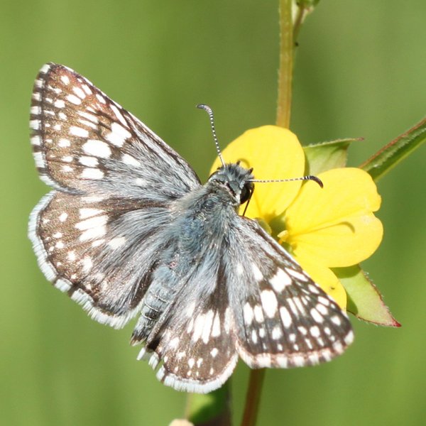
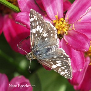
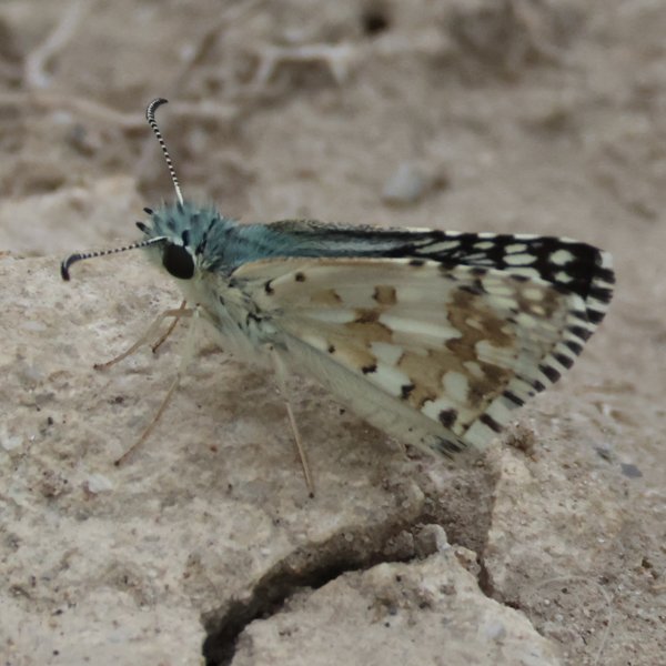
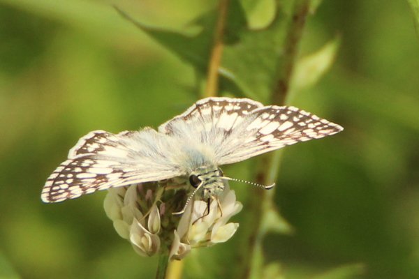
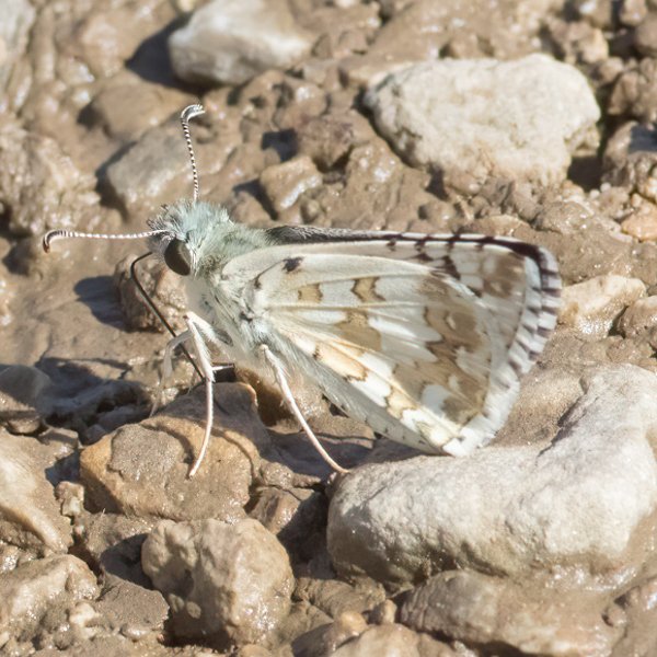
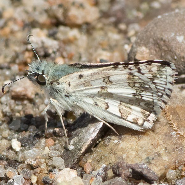
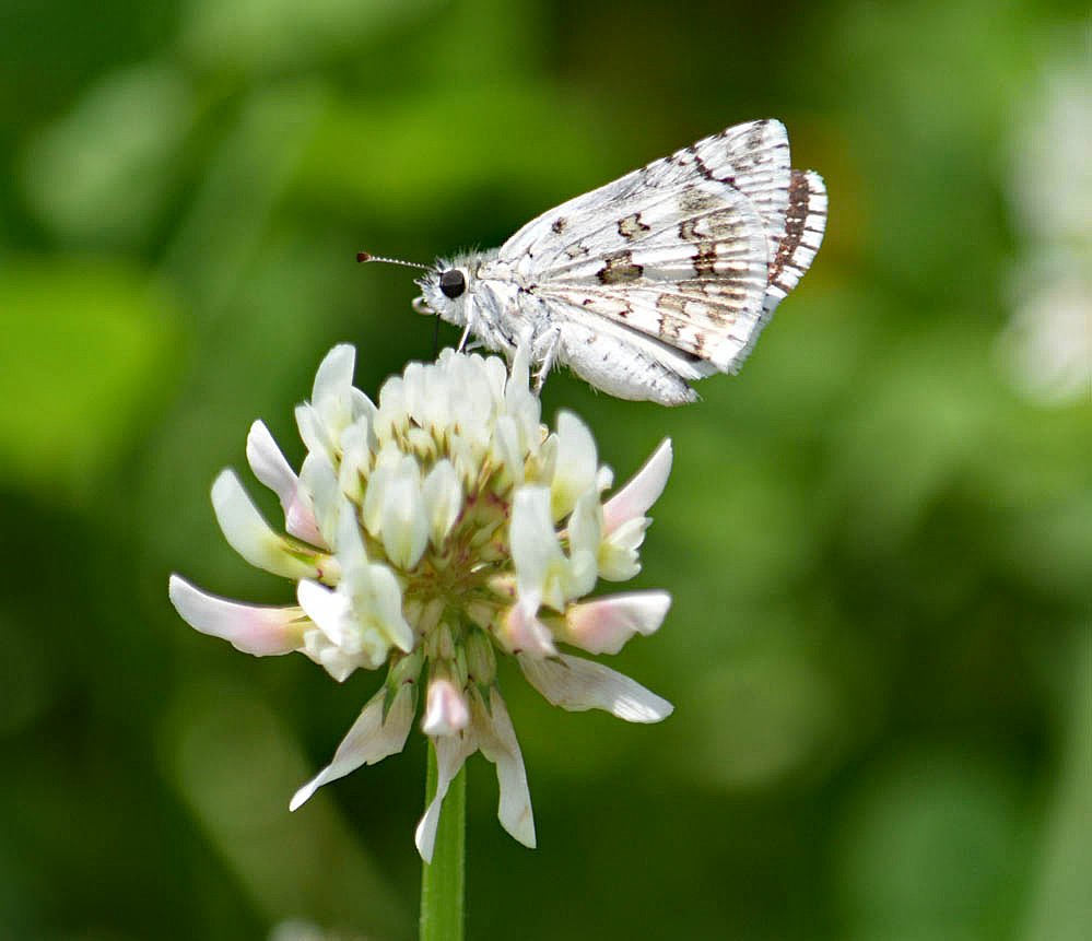
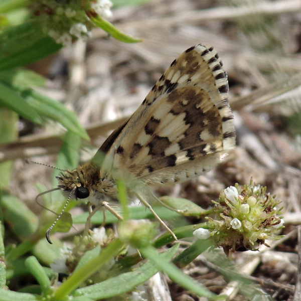
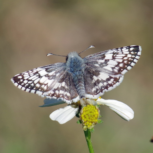
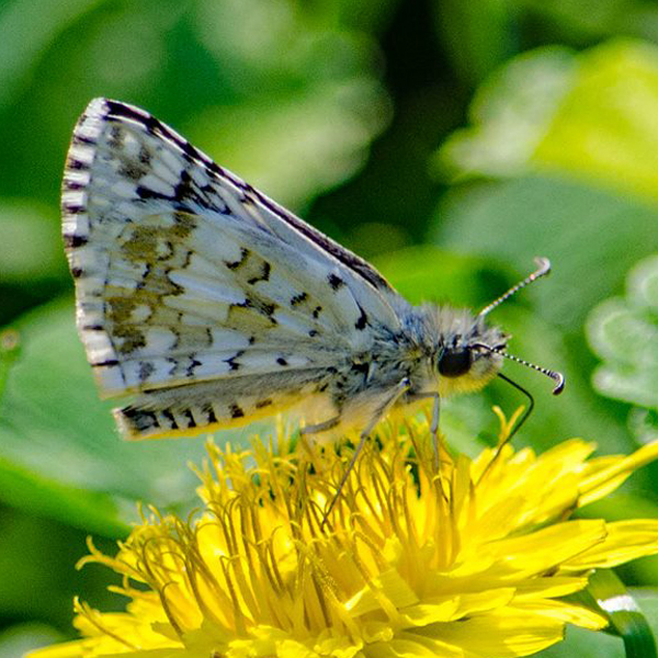
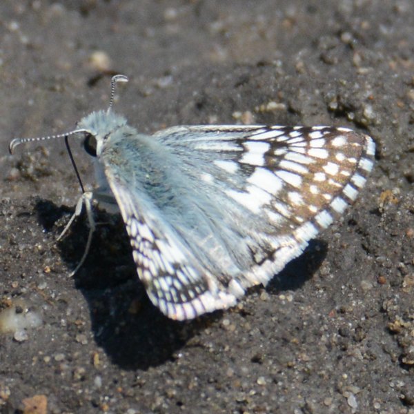
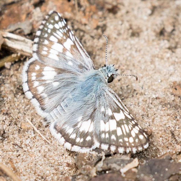
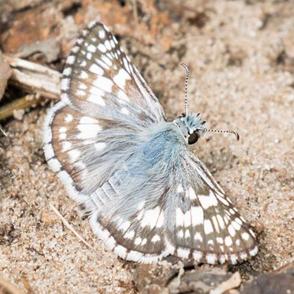
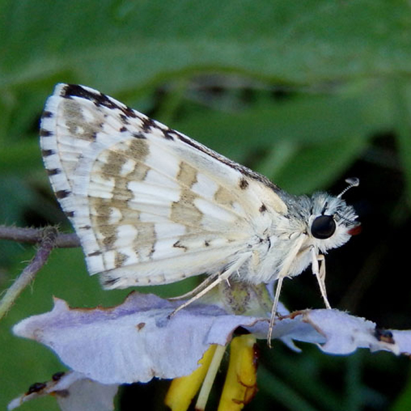
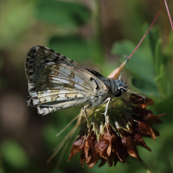
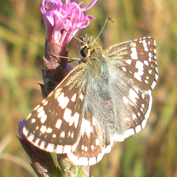
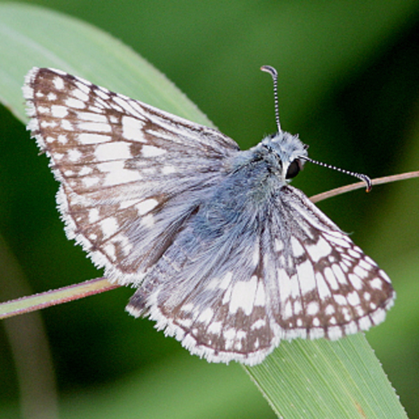
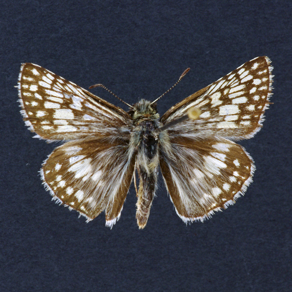
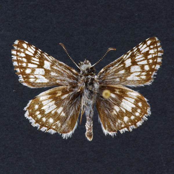
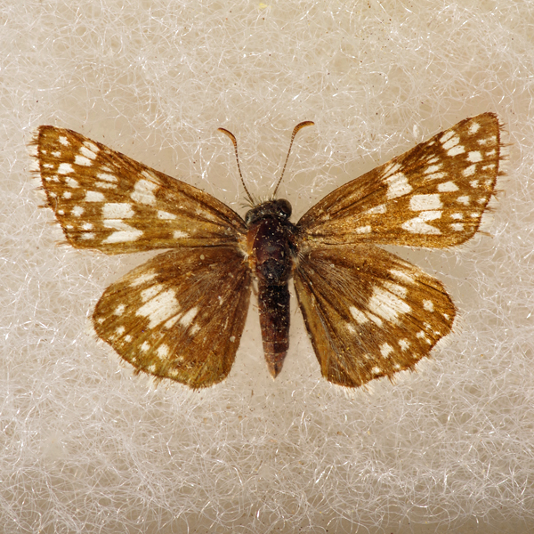
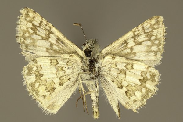
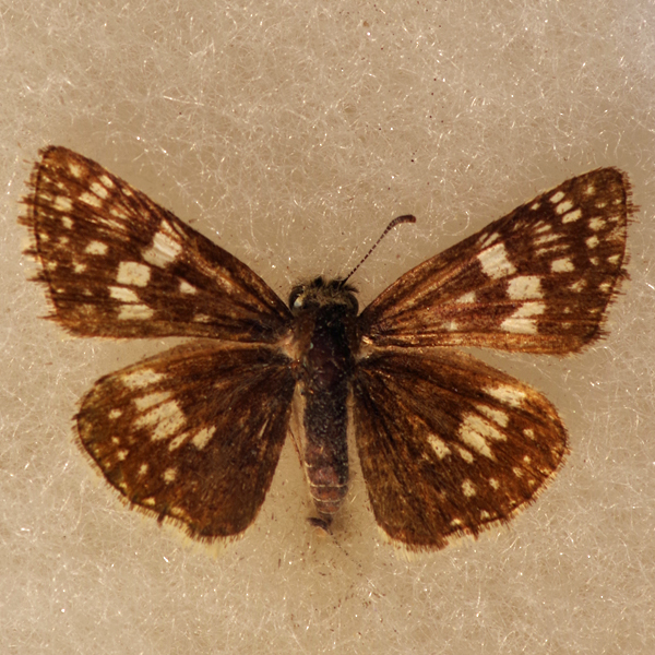
Wing span: 2.7-3.2 cm.
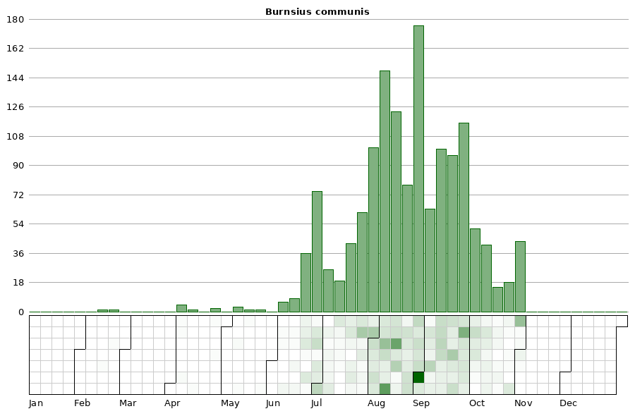
Flight time: The first adults will migrate from the south in early April through May. The bulk of flight occurs from the end of June to the first of October, although individuals have been encountered as late as early November.
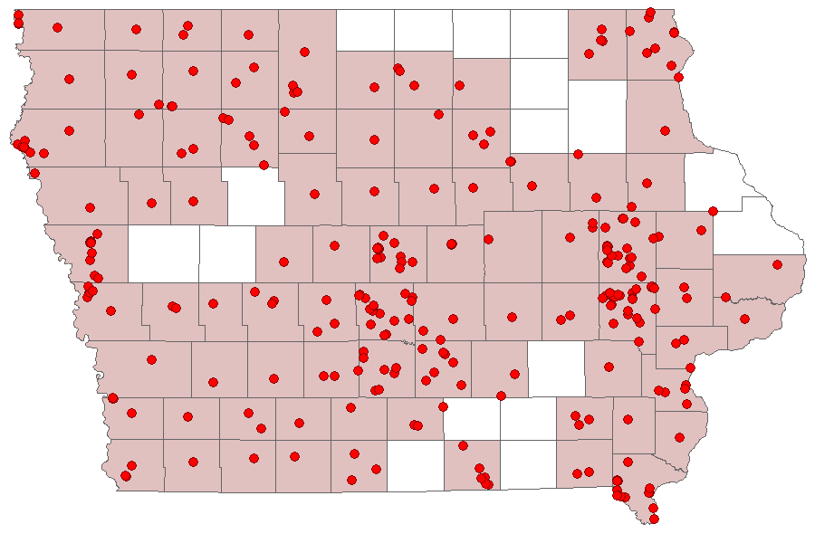
Status: Common, non-overwintering, resident.
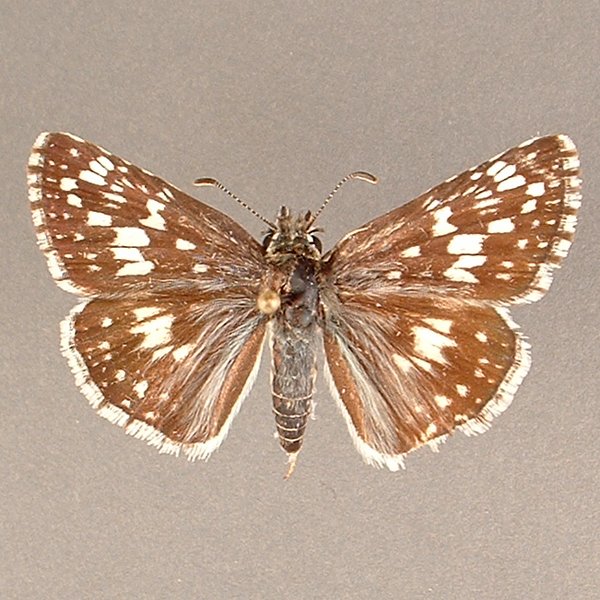
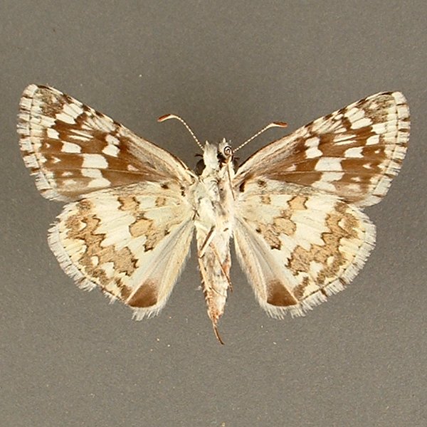
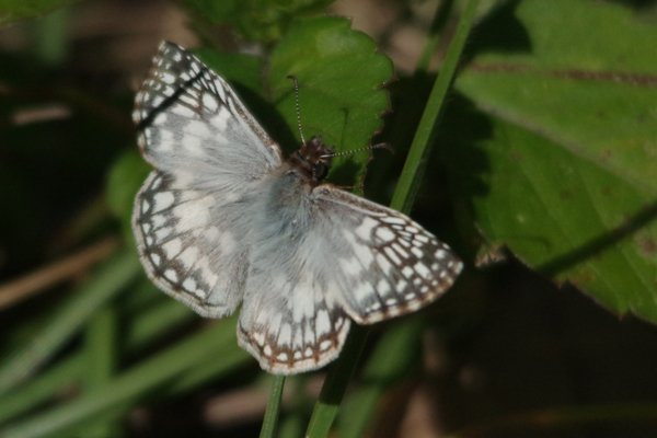
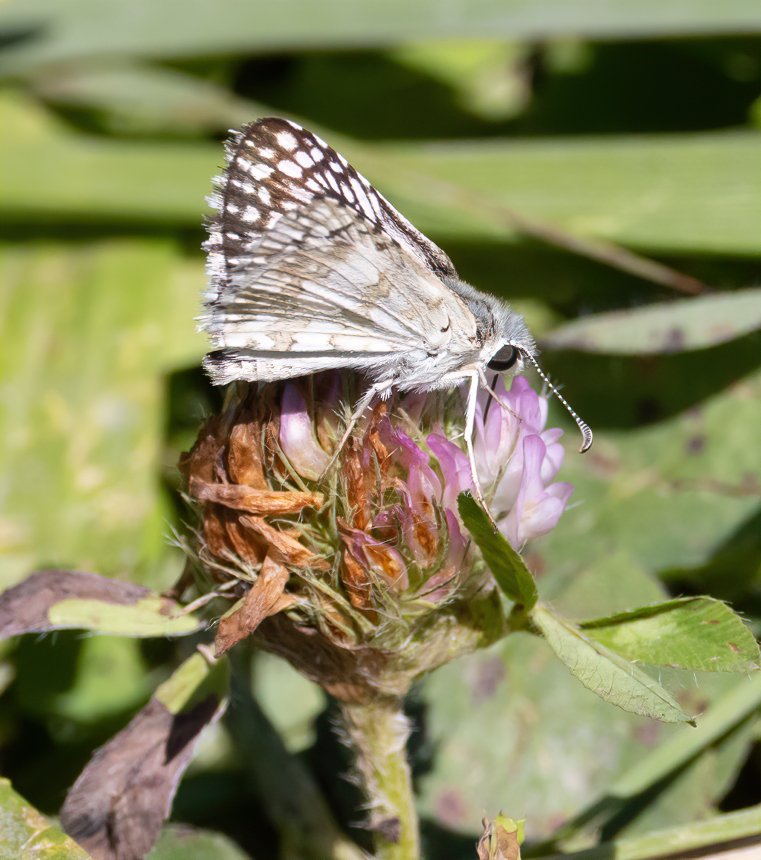
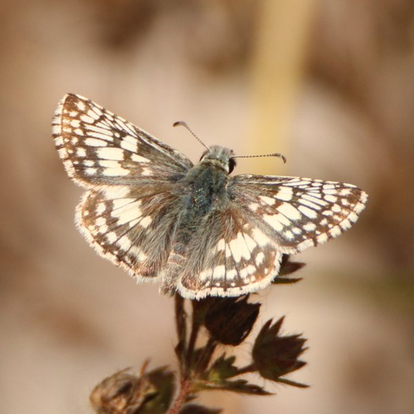
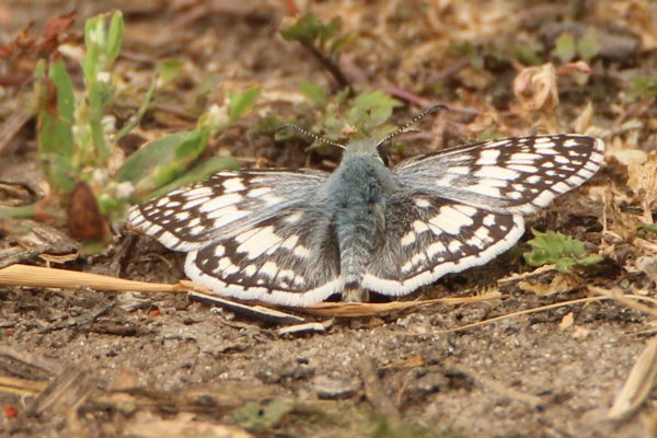
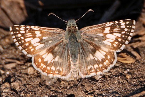
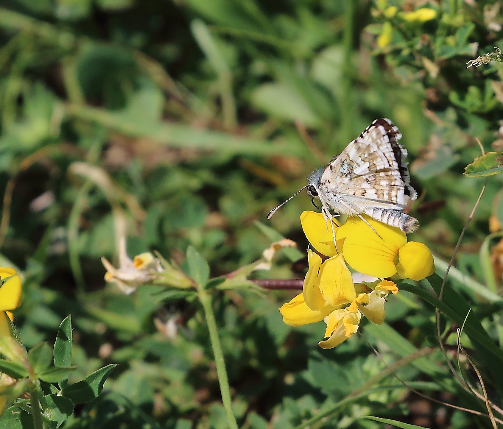
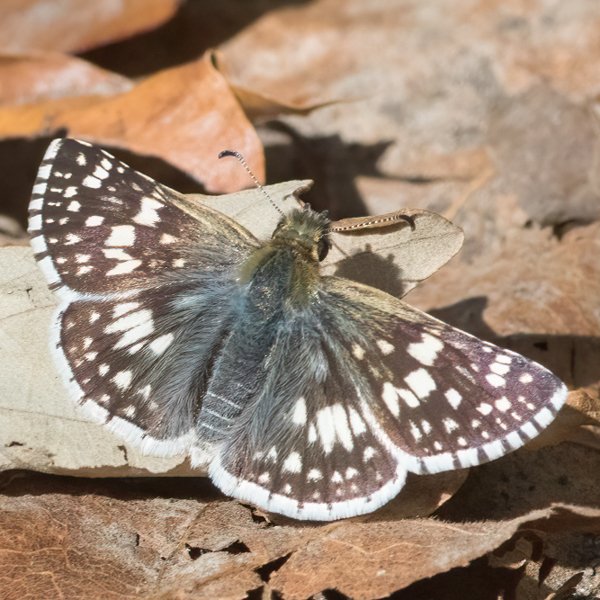
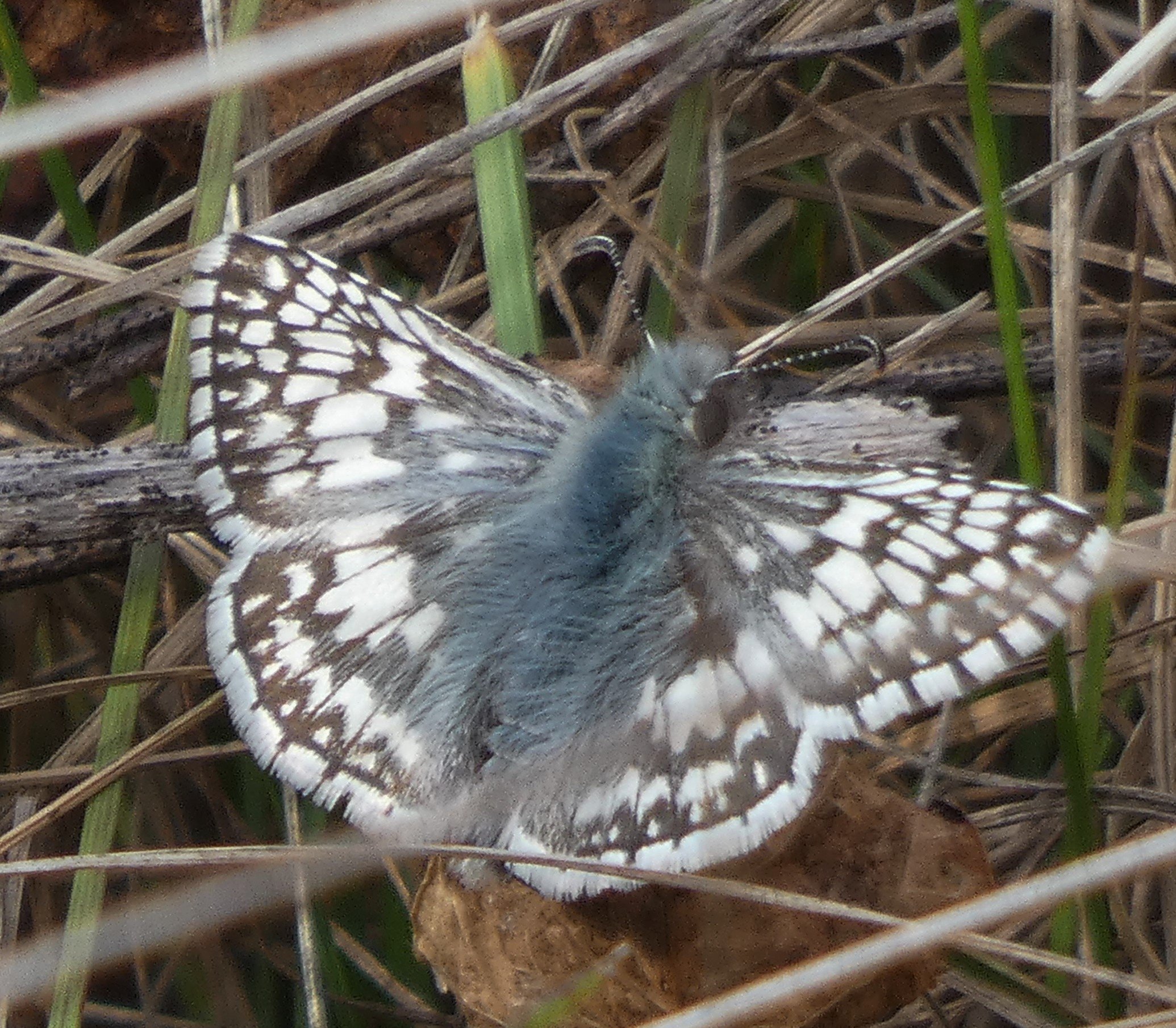
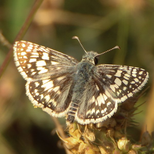
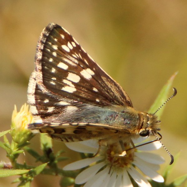
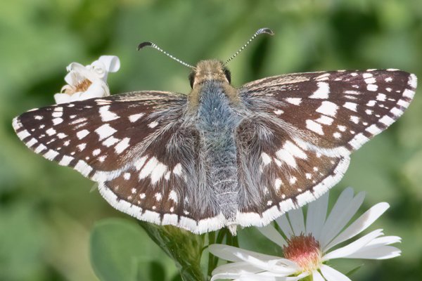
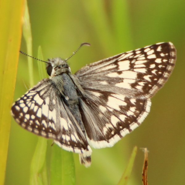
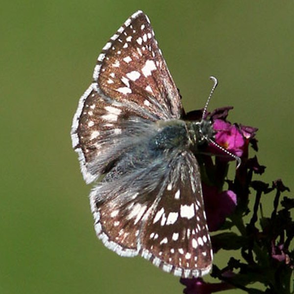
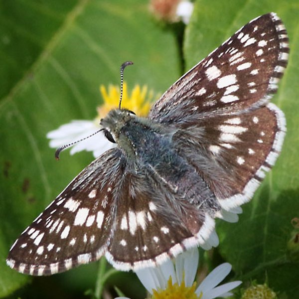
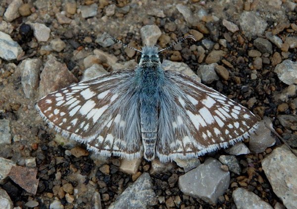
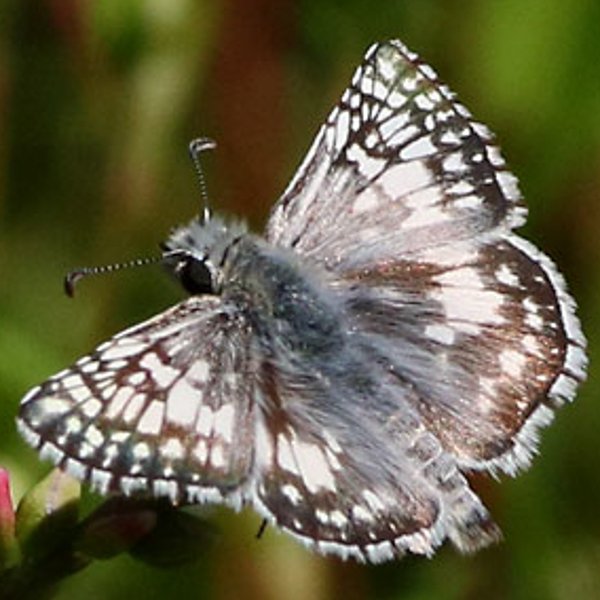
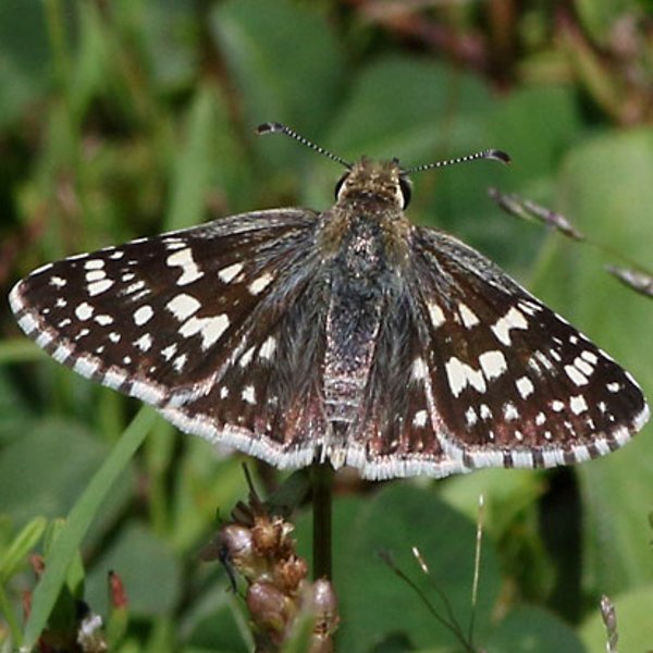
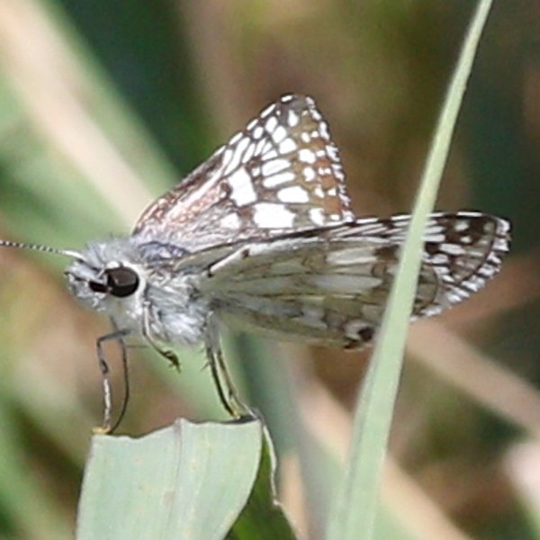
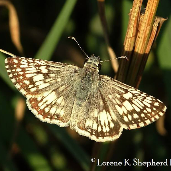
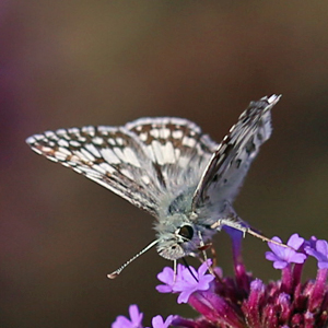
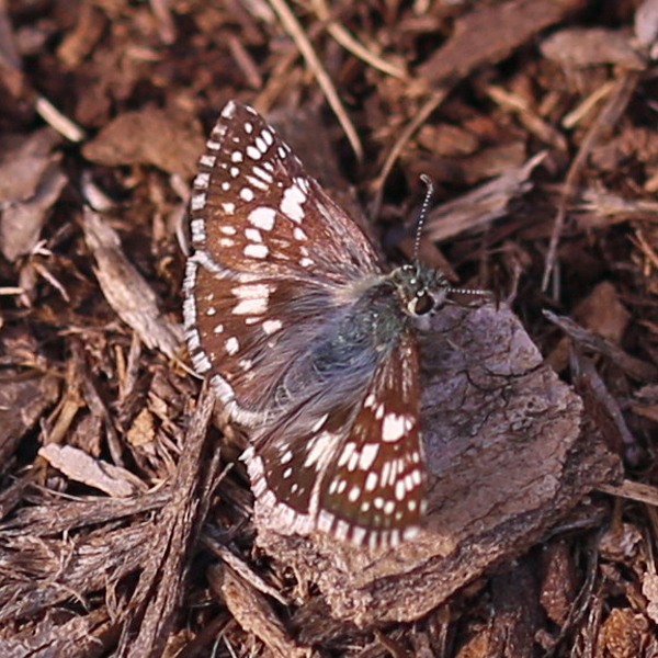
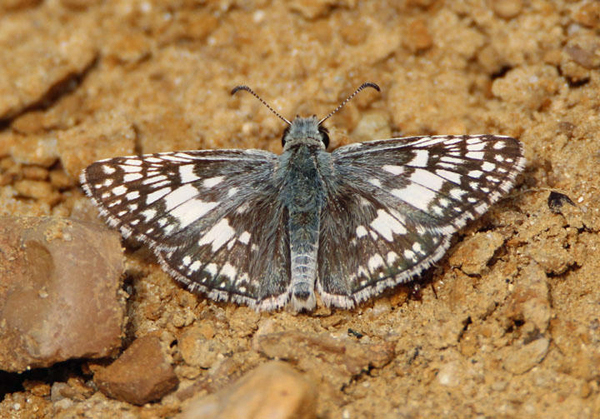
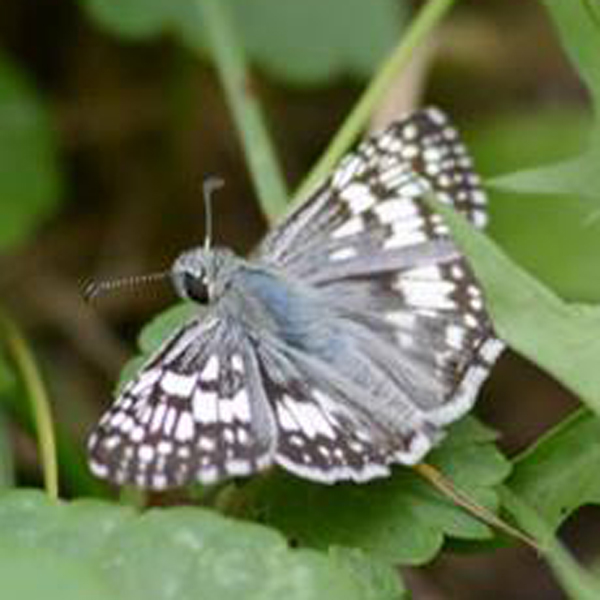
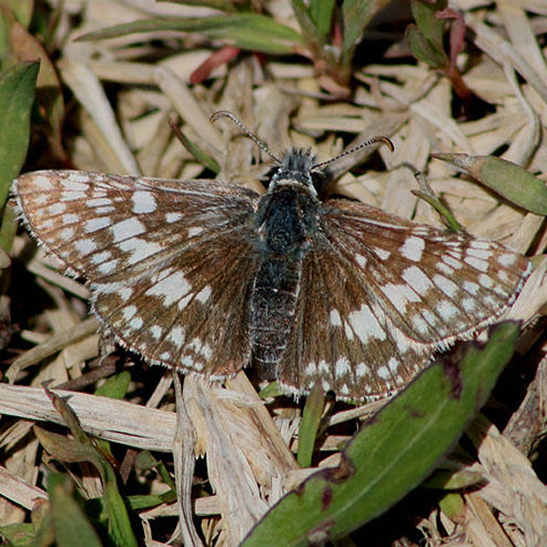
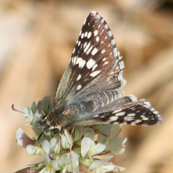
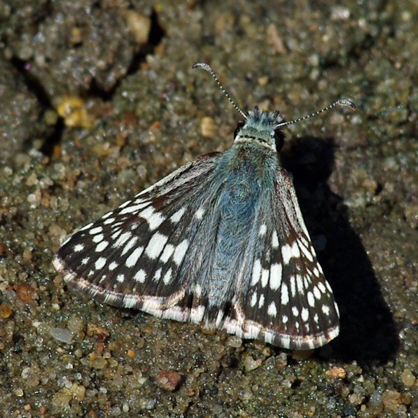
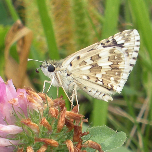
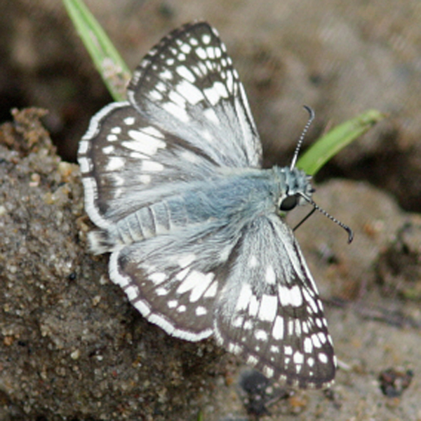
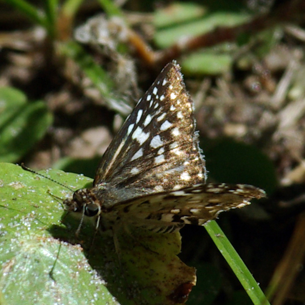
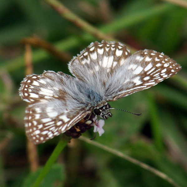
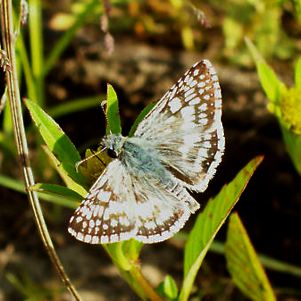
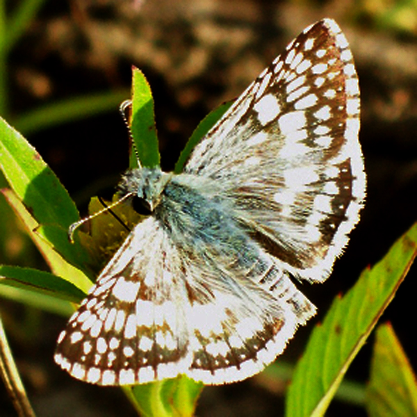
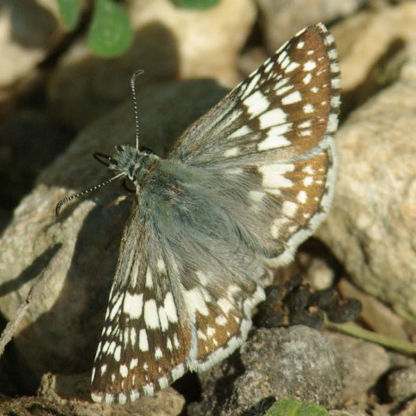
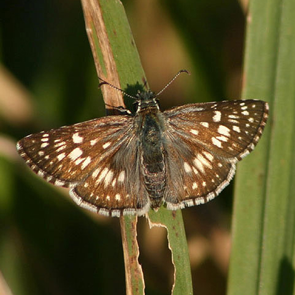
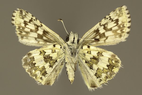
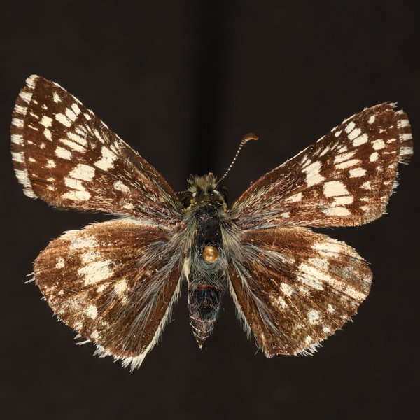
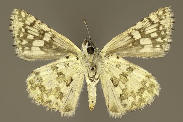
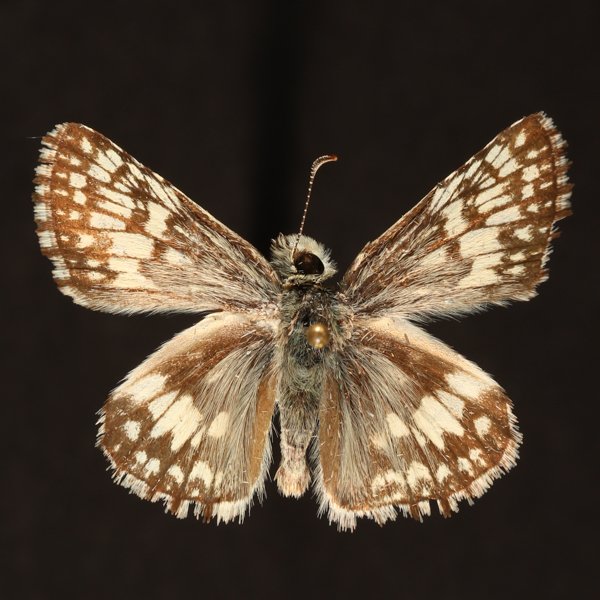
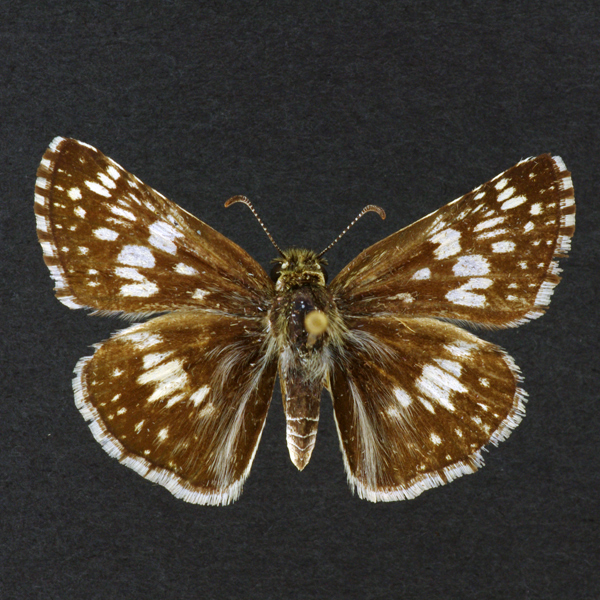
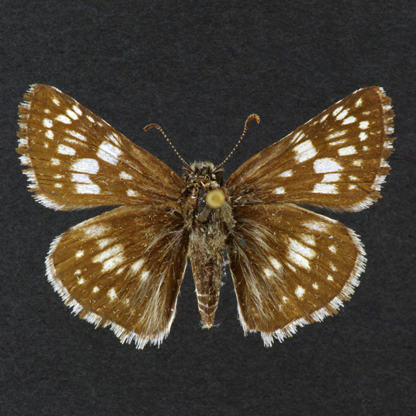
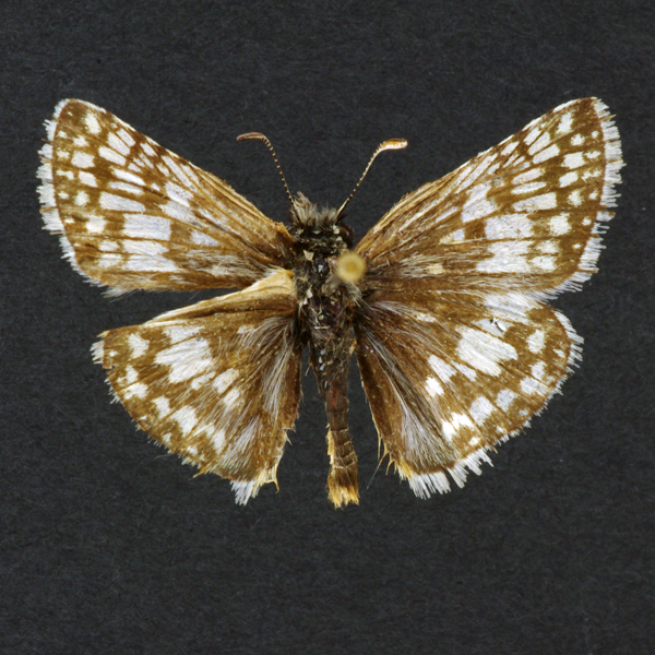
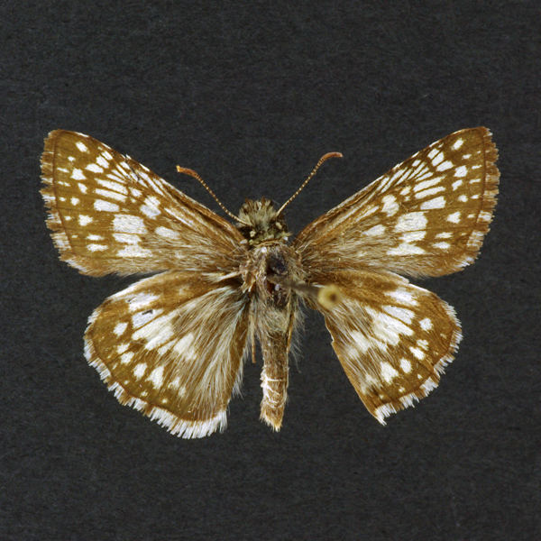
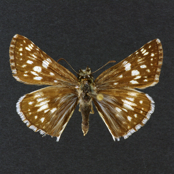
Distinguishing features: As its name implies this skipper is heavily white-checkered on a gray background. Specimens vary from quite dark to light in overall appearance. The hindwing below has 3 jagged transverse bands.
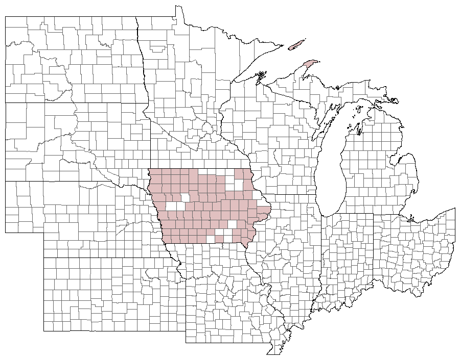
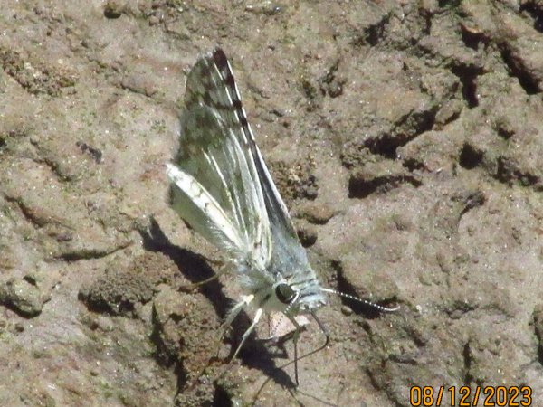
Distribution and habitat: Found throughout the state in a wide variety of native and altered habitats. It is frequently encountered in sunny areas with low vegetation such as farm lots, heavily grazed pastures, and roadsides.
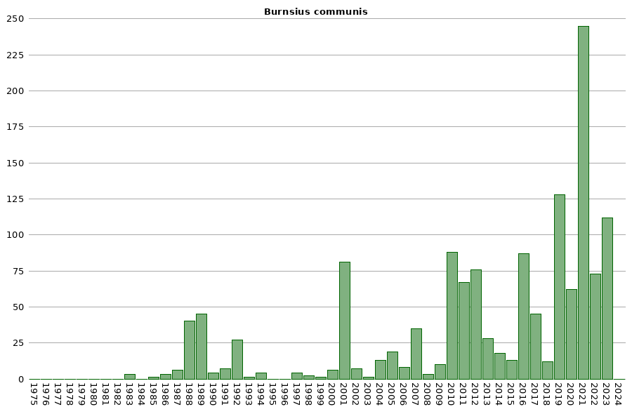
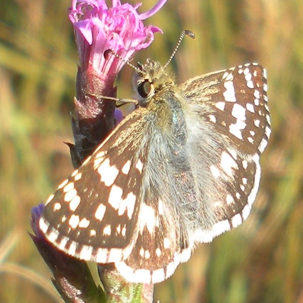
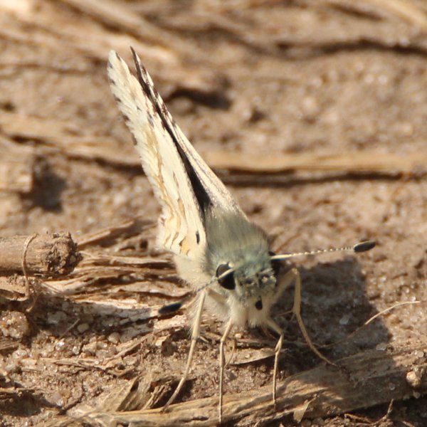
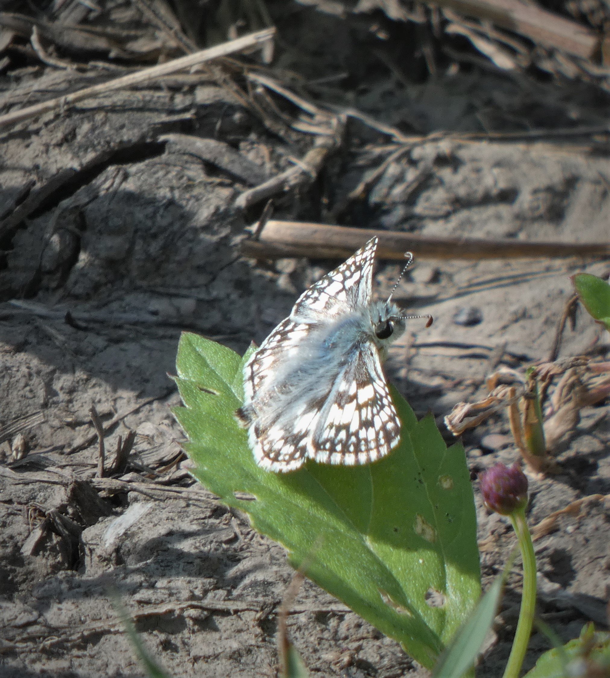
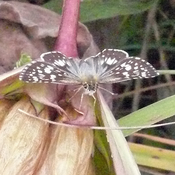
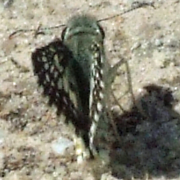
Natural History: Larvae have been reported to feed on a number of weedy species in the Mallow family (Malvaceae). The Checkered Skipper can be common in some years and infrequent in others. The male with the unexpanded left hindwing in Figure 106 was taken in copula in Osceola County. Little is known about its courtship behavior, but this collection indicates that male flight activity does not play a critical role in female mate choice, and that females may play an important role in moving genes.


| Record # | Date | Locale | State | Lat/Lon | Collected By | Count |
|---|---|---|---|---|---|---|
 346374 346374
|
2023-10-01 | Slip Bluff County Park | Iowa | 40.652884 -93.847544 | Jay Gilliam | 1 |
| 349649 | 2023-08-19 | Cedar River Crossing Conservation Area | IA | 41.836408 -91.40124 | Chris Edwards | 5 |
| 350211 | 2023-08-18 | Sugar Bottom Recreational Area | IA | 41.761676 -91.554925 | Chris Edwards | 2 |
 344355 344355
|
2023-08-12 | Turkey Run Access | Iowa | 40.550592 -91.654215 | Frank Olsen | 15 |
| 344385 | 2023-08-12 | Turkey Run Wildlife Area, Lee County | Iowa | 40.558402 -91.679173 | Frank Olsen | 2 |
 346182 346182
|
2023-08-12 | Heron Bend-North | Iowa | 40.602955 -91.416506 | Jay Gilliam | 26 |
| 347011 | 2023-08-12 | Turkey Run Wildlife Area, Lee County | Iowa | 40.557863 -91.680371 | Jay Gilliam | 2 |
| 344358 | 2023-07-09 | Turkey Run Access | Iowa | 40.550592 -91.654215 | Frank Olsen | 3 |
| 346758 | 2023-07-03 | Hidden Bridge Wildlife Area | Iowa | 43.420363 -96.565971 | Jay Gilliam | 3 |
| 346700 | 2023-07-01 | Deer Creek Wildlife Management Area | Iowa | 42.718031 -96.511437 | Jay Gilliam | 1 |
| 346711 | 2023-07-01 | Five Ridge Prairie State Preserve | Iowa | 42.679143 -96.523488 | Jay Gilliam | 1 |
 343074 343074
|
2023-06-25 | Shimek State Forest, Croton Unit East | Iowa | 40.5458514 -91.61607455 | Mark Brown | 1 |
| 346669 | 2023-06-25 | Turkey Run Access | Iowa | 40.550464 -91.654152 | Jay Gilliam | 1 |
| 350249 | 2023-06-25 | Turkey Run Access | IA | 40.550644 -91.654633 | Chris Edwards | 1 |
| 350285 | 2023-06-25 | Turkey Run Wildlife Area, Lee County | IA | 40.558402 -91.679173 | Chris Edwards | 1 |
| 346548 | 2023-06-17 | Eddyville Cemetery Wetland | Iowa | 41.167726 -92.631735 | Jay Gilliam | 2 |
| 330525 | 2022-11-01 | Easter Lake | Iowa | 41.545422 -93.56662 | IBSN | 2 |
| 330527 | 2022-11-01 | Easter Lake | Iowa | 41.545422 -93.56662 | IBSN | 3 |
| 330522 | 2022-10-31 | Easter Lake | Iowa | 41.545422 -93.56662 | IBSN | 1 |
| 330519 | 2022-10-29 | Easter Lake | Iowa | 41.545422 -93.56662 | IBSN | 2 |
| 330524 | 2022-10-28 | Easter Lake | Iowa | 41.545422 -93.56662 | IBSN | 11 |
| 330520 | 2022-10-22 | Easter Lake | Iowa | 41.545422 -93.56662 | IBSN | 2 |
| 330521 | 2022-10-22 | Easter Lake | Iowa | 41.545422 -93.56662 | IBSN | 1 |
| 330526 | 2022-10-22 | Easter Lake | Iowa | 41.545422 -93.56662 | IBSN | 1 |
| 330523 | 2022-10-21 | Easter Lake | Iowa | 41.545422 -93.56662 | IBSN | 1 |
 333436 333436
|
2022-10-02 | Hawkeye Willdlife Management Area | Iowa | 41.79979371 -91.74133153 | Mark Brown | 1 |
| 331824 | 2022-09-20 | Turkey Run Wildlife Area, Lee County | Iowa | 40.558402 -91.679173 | Chris Edwards | 2 |
| 330506 | 2022-09-14 | Ada Hayden Heritage Park | Iowa | 42.0638 -93.636305 | IBSN | 1 |
| 330507 | 2022-09-13 | Ada Hayden Heritage Park | Iowa | 42.0638 -93.636305 | IBSN | 1 |
| 330517 | 2022-09-13 | Chain Lakes County Park | Iowa | 42.059065 -91.763772 | IBSN | 1 |
| 330508 | 2022-09-12 | Ada Hayden Heritage Park | Iowa | 42.0638 -93.636305 | IBSN | 2 |
 332758 332758
|
2022-09-10 | Cedar River Crossing Conservation Area | Iowa | 41.84138671 -91.40036658 | Mark Brown | 1 |
| 317371 | 2022-09-07 | Turkey Run Wildlife Area, Lee County | Iowa | 40.558402 -91.679173 | Frank Olsen | 4 |
| 330516 | 2022-09-07 | Chain Lakes County Park | Iowa | 42.059065 -91.763772 | IBSN | 1 |
 332801 332801
|
2022-08-27 | Ciha Fen Wildlife Preserve | Iowa | 41.82911626 -91.38159239 | Mark Brown | 1 |
| 331718 | 2022-08-21 | Turkey Run Wildlife Area, Lee County | Iowa | 40.558402 -91.679173 | Chris Edwards | 1 |
 332838 332838
|
2022-08-20 | Cedar River Crossing Conservation Area | Iowa | 41.84138671 -91.40036658 | Mark Brown | 1 |
| 330530 | 2022-08-18 | Port Louisa National Wildlife Refuge | Iowa | 41.239649 -91.124611 | IBSN | 1 |
| 317357 | 2022-08-17 | Turkey Run Wildlife Area, Lee County | Iowa | 40.558402 -91.679173 | Frank Olsen | 2 |
| 331586 | 2022-08-17 | Cedar River Crossing Conservation Area | Iowa | 41.836408 -91.40124 | Chris Edwards | 6 |
 331905 331905
|
2022-08-16 | Hawkeye Willdlife Management Area | Iowa | 41.788388 -91.675463 | Mark Brown | 1 |
| 330529 | 2022-08-13 | Jennett Heritage Area | Iowa | 41.950832 -93.456793 | IBSN | 1 |
| 330515 | 2022-08-10 | Chain Lakes County Park | Iowa | 42.059065 -91.763772 | IBSN | 1 |
| 330528 | 2022-08-03 | Hidden Bridge Wildlife Area | Iowa | 43.415681 -96.563796 | IBSN | 2 |
| 317343 | 2022-07-29 | Turkey Run Wildlife Area, Lee County | Iowa | 40.558402 -91.679173 | Frank Olsen | 2 |
| 330514 | 2022-07-28 | Chain Lakes County Park | Iowa | 42.059065 -91.763772 | IBSN | 1 |
| 318270 | 2022-07-24 | Coyote Canyon Wildlife Area | Iowa | 41.099428 -93.858554 | Jay Gilliam | 3 |
| 330513 | 2022-07-24 | Chain Lakes County Park | Iowa | 42.059065 -91.763772 | IBSN | 1 |
| 318242 | 2022-07-23 | Hoffman Prairie | Iowa | 43.134092 -93.455582 | Jay Gilliam | 1 |
| 330512 | 2022-07-23 | Chain Lakes County Park | Iowa | 42.059065 -91.763772 | IBSN | 2 |
| 330511 | 2022-07-17 | Chain Lakes County Park | Iowa | 42.059065 -91.763772 | IBSN | 1 |
| 330510 | 2022-07-16 | Chain Lakes County Park | Iowa | 42.059065 -91.763772 | IBSN | 1 |
| 330518 | 2022-07-07 | Easter Lake | Iowa | 41.545422 -93.56662 | IBSN | 1 |
 318128 318128
|
2022-07-01 | Hidden Bridge Wildlife Area | Iowa | 43.420363 -96.565971 | Jay Gilliam | 3 |
 310563 310563
|
2022-06-20 | Ada Hayden Heritage Park | Iowa | 42.064309 -93.636543 | Wolfgang Oesterreich | 1 |
| 330509 | 2022-06-12 | Chain Lakes County Park | Iowa | 42.059065 -91.763772 | IBSN | 1 |
| 297843 | 2021-10-30 | Center Point | Iowa | 42.195036 -91.779263 | Dennis Schlicht | 1 |
| 297822 | 2021-10-19 | Wickiup Hill Outdoor Learning Area | Iowa | 42.082411 -91.762504 | Frank Olsen | 2 |
| 301173 | 2021-10-17 | Red Rock Reservoir- Hwy 14 & G28 | Iowa | 41.434442 -93.10052 | Jay Gilliam | 1 |
| 306675 | 2021-10-17 | Easter Lake | Iowa | 41.545422 -93.56662 | IBSN | 1 |
 301169 301169
|
2021-10-16 | Pammel State Park | Iowa | 41.294986 -94.074903 | Jay Gilliam | 1 |
 296068 296068
|
2021-10-15 | Hawkeye Willdlife Management Area | Iowa | 41.783153 -91.661213 | Mark Madsen | 1 |
| 306644 | 2021-10-14 | F. W. Kent Park | Iowa | 41.723806 -91.736417 | IBSN | 1 |
 298060 298060
|
2021-10-09 | Johnson County, Iowa | Iowa | Location Protected | Mark Brown | 1 |
 298090 298090
|
2021-10-03 | Slip Bluff County Park | Iowa | 40.65307194 -93.84647182 | Mark Brown | 1 |
| 306659 | 2021-10-03 | Ada Hayden Heritage Park | Iowa | 42.066757 -93.635499 | IBSN | 2 |
| 306643 | 2021-10-02 | Chain Lakes County Park | Iowa | 42.059065 -91.763772 | IBSN | 9 |
| 306680 | 2021-10-02 | Jester Park | Iowa | 41.786297 -93.788656 | IBSN | 1 |
| 306706 | 2021-09-29 | Chain Lakes County Park | Iowa | 42.059065 -91.763772 | IBSN | 6 |
| 306653 | 2021-09-27 | Ada Hayden Heritage Park | Iowa | 42.066757 -93.635499 | IBSN | 3 |
| 306657 | 2021-09-27 | Chain Lakes County Park | Iowa | 42.059065 -91.763772 | IBSN | 5 |
| 306674 | 2021-09-27 | Easter Lake | Iowa | 41.545422 -93.56662 | IBSN | 1 |
| 306705 | 2021-09-26 | Chain Lakes County Park | Iowa | 42.059065 -91.763772 | IBSN | 3 |
 301108 301108
|
2021-09-25 | Cordova Park | Iowa | 41.42552 -93.089529 | Jay Gilliam | 1 |
| 306693 | 2021-09-25 | Ada Hayden Heritage Park | Iowa | 42.066757 -93.635499 | IBSN | 2 |
| 306658 | 2021-09-23 | Voas Nature Area | Iowa | 41.757494 -94.05544 | IBSN | 2 |
| 306699 | 2021-09-23 | Chain Lakes County Park | Iowa | 42.059065 -91.763772 | IBSN | 5 |
| 306663 | 2021-09-22 | Ada Hayden Heritage Park | Iowa | 42.066757 -93.635499 | IBSN | 4 |
| 306700 | 2021-09-21 | Easter Lake | Iowa | 41.545422 -93.56662 | IBSN | 1 |
| 306660 | 2021-09-19 | Ada Hayden Heritage Park | Iowa | 42.066757 -93.635499 | IBSN | 1 |
| 301107 | 2021-09-18 | Pammel State Park | Iowa | 41.294986 -94.074903 | Jay Gilliam | 1 |
| 306662 | 2021-09-17 | Chain Lakes County Park | Iowa | 42.059065 -91.763772 | IBSN | 8 |
| 306665 | 2021-09-15 | Chain Lakes County Park | Iowa | 42.059065 -91.763772 | IBSN | 4 |
| 306695 | 2021-09-15 | Ada Hayden Heritage Park | Iowa | 42.066757 -93.635499 | IBSN | 2 |
| 306645 | 2021-09-13 | Ada Hayden Heritage Park | Iowa | 42.066757 -93.635499 | IBSN | 1 |
 295185 295185
|
2021-09-12 | Cedar River Crossing Conservation Area | Iowa | 41.840277 -91.396757 | Mark Madsen | 1 |
| 306667 | 2021-09-10 | Ada Hayden Heritage Park | Iowa | 42.066757 -93.635499 | IBSN | 1 |
| 306688 | 2021-08-30 | Chain Lakes County Park | Iowa | 42.059065 -91.763772 | IBSN | 3 |
| 306664 | 2021-08-29 | Chain Lakes County Park | Iowa | 42.059065 -91.763772 | IBSN | 5 |
| 306692 | 2021-08-29 | Ada Hayden Heritage Park | Iowa | 42.066757 -93.635499 | IBSN | 1 |
| 306689 | 2021-08-26 | F. W. Kent Park | Iowa | 41.723806 -91.736417 | IBSN | 1 |
| 306656 | 2021-08-23 | Chain Lakes County Park | Iowa | 42.059065 -91.763772 | IBSN | 2 |
| 306704 | 2021-08-22 | Chain Lakes County Park | Iowa | 42.059065 -91.763772 | IBSN | 3 |
| 297788 | 2021-08-17 | Wickiup Hill Outdoor Learning Area | Iowa | 42.082411 -91.762504 | Frank Olsen | 3 |
| 306648 | 2021-08-17 | Ada Hayden Heritage Park | Iowa | 42.066757 -93.635499 | IBSN | 10 |
| 306687 | 2021-08-17 | Port Louisa National Wildlife Refuge | Iowa | 41.239649 -91.124611 | IBSN | 1 |
| 306683 | 2021-08-15 | Ada Hayden Heritage Park | Iowa | 42.066757 -93.635499 | IBSN | 13 |
 300948 300948
|
2021-08-14 | Turkey Run Wildlife Area, Lee County | Iowa | 40.557863 -91.680372 | Jay Gilliam | 1 |
| 306670 | 2021-08-14 | Chain Lakes County Park | Iowa | 42.059065 -91.763772 | IBSN | 10 |
 291580 291580
|
2021-08-13 | Maskunky Marsh | Iowa | 41.303926 -92.517898 | Mark Madsen | 1 |
| 306652 | 2021-08-13 | Ada Hayden Heritage Park | Iowa | 42.066757 -93.635499 | IBSN | 8 |
| 306698 | 2021-08-11 | Chain Lakes County Park | Iowa | 42.059065 -91.763772 | IBSN | 5 |
| 306650 | 2021-08-09 | Chain Lakes County Park | Iowa | 42.059065 -91.763772 | IBSN | 5 |
| 306647 | 2021-08-08 | Chain Lakes County Park | Iowa | 42.059065 -91.763772 | IBSN | 4 |
| 306671 | 2021-08-08 | Ada Hayden Heritage Park | Iowa | 42.066757 -93.635499 | IBSN | 3 |
| 308592 | 2021-08-07 | Cedar River Crossing Conservation Area | Iowa | 41.836408 -91.40124 | Chris Edwards | 6 |
| 306655 | 2021-08-06 | Chain Lakes County Park | Iowa | 42.059065 -91.763772 | IBSN | 3 |
| 306649 | 2021-08-04 | Chain Lakes County Park | Iowa | 42.059065 -91.763772 | IBSN | 6 |
| 306669 | 2021-08-03 | Chain Lakes County Park | Iowa | 42.059065 -91.763772 | IBSN | 4 |
| 306708 | 2021-08-03 | Ada Hayden Heritage Park | Iowa | 42.066757 -93.635499 | IBSN | 1 |
| 306642 | 2021-08-02 | Chain Lakes County Park | Iowa | 42.059065 -91.763772 | IBSN | 7 |
| 306691 | 2021-08-02 | Port Louisa National Wildlife Refuge | Iowa | 41.239649 -91.124611 | IBSN | 1 |
| 306661 | 2021-08-01 | Ada Hayden Heritage Park | Iowa | 42.066757 -93.635499 | IBSN | 4 |
| 306666 | 2021-08-01 | Churchville Prairie | Iowa | 41.405565 -93.751417 | IBSN | 1 |
| 306668 | 2021-08-01 | Chain Lakes County Park | Iowa | 42.059065 -91.763772 | IBSN | 3 |
| 306707 | 2021-07-31 | Ada Hayden Heritage Park | Iowa | 42.066757 -93.635499 | IBSN | 3 |
| 306686 | 2021-07-28 | Chain Lakes County Park | Iowa | 42.059065 -91.763772 | IBSN | 2 |
| 306697 | 2021-07-27 | Chain Lakes County Park | Iowa | 42.059065 -91.763772 | IBSN | 2 |
| 306703 | 2021-07-26 | Chain Lakes County Park | Iowa | 42.059065 -91.763772 | IBSN | 3 |
| 306646 | 2021-07-25 | Chain Lakes County Park | Iowa | 42.059065 -91.763772 | IBSN | 1 |
| 306684 | 2021-07-18 | Ada Hayden Heritage Park | Iowa | 42.07214 -93.625959 | IBSN | 1 |
| 306702 | 2021-07-16 | Ada Hayden Heritage Park | Iowa | 42.066757 -93.635499 | IBSN | 1 |
| 296872 | 2021-07-13 | Clear Creek Fen | Iowa | 43.455306 -91.42388 | Frank Olsen | 1 |
| 306673 | 2021-07-09 | Chain Lakes County Park | Iowa | 42.059065 -91.763772 | IBSN | 2 |
| 306676 | 2021-07-09 | Ada Hayden Heritage Park | Iowa | 42.07214 -93.625959 | IBSN | 1 |
| 306678 | 2021-07-03 | Ada Hayden Heritage Park | Iowa | 42.066757 -93.635499 | IBSN | 1 |
| 306654 | 2021-06-30 | Chain Lakes County Park | Iowa | 42.059065 -91.763772 | IBSN | 2 |
| 306696 | 2021-06-28 | Chain Lakes County Park | Iowa | 42.059065 -91.763772 | IBSN | 1 |
| 306651 | 2021-06-27 | Ada Hayden Heritage Park | Iowa | 42.066757 -93.635499 | IBSN | 7 |
| 306672 | 2021-06-27 | Wapsi River Environmental Center | Iowa | 41.772696 -90.794985 | IBSN | 1 |
| 306685 | 2021-06-27 | Ada Hayden Heritage Park | Iowa | 42.07214 -93.625959 | IBSN | 2 |
| 306681 | 2021-06-23 | Ada Hayden Heritage Park | Iowa | 42.066757 -93.635499 | IBSN | 9 |
| 306694 | 2021-06-20 | Ada Hayden Heritage Park | Iowa | 42.07214 -93.625959 | IBSN | 1 |
| 306701 | 2021-06-20 | Ada Hayden Heritage Park | Iowa | 42.066757 -93.635499 | IBSN | 6 |
| 306677 | 2021-06-19 | Hertz Family Woods and Nature Preserve | Iowa | 41.989593 -93.441166 | IBSN | 2 |
| 306682 | 2021-06-19 | Ada Hayden Heritage Park | Iowa | 42.066757 -93.635499 | IBSN | 2 |
| 306679 | 2021-06-18 | Ada Hayden Heritage Park | Iowa | 42.066757 -93.635499 | IBSN | 4 |
| 306690 | 2021-05-13 | Port Louisa National Wildlife Refuge | Iowa | 41.239649 -91.124611 | IBSN | 1 |
| 281874 | 2020-10-11 | Lake Sugema Wildlife Area | Iowa | 40.692123 -92.006746 | Chris Edwards | 1 |
| 286186 | 2020-10-08 | Chain Lakes County Park | Iowa | 42.057726 -91.763904 | IBSN | 2 |
| 281873 | 2020-10-04 | F. W. Kent Park | Iowa | 41.72916 -91.727161 | Chris Edwards | 1 |
| 286185 | 2020-09-25 | Chain Lakes County Park | Iowa | 42.057726 -91.763904 | IBSN | 1 |
| 286184 | 2020-09-23 | Chain Lakes County Park | Iowa | 42.057726 -91.763904 | IBSN | 2 |
| 286183 | 2020-09-22 | Chain Lakes County Park | Iowa | 42.057726 -91.763904 | IBSN | 1 |
| 286182 | 2020-09-17 | Chain Lakes County Park | Iowa | 42.057726 -91.763904 | IBSN | 4 |
| 274372 | 2020-09-16 | Turkey Run Access | Iowa | 40.550592 -91.654215 | Frank Olsen | 1 |
| 286181 | 2020-09-16 | Chain Lakes County Park | Iowa | 42.057726 -91.763904 | IBSN | 2 |
| 286179 | 2020-09-15 | Ada Hayden Heritage Park | Iowa | 42.067913 -93.629339 | IBSN | 1 |
| 286180 | 2020-09-15 | Chain Lakes County Park | Iowa | 42.057726 -91.763904 | IBSN | 1 |
| 273411 | 2020-09-14 | Hitaga Sand Ridge Prairie Preserve | Iowa | 42.25088 -91.632179 | Frank Olsen | 1 |
| 281872 | 2020-09-13 | Hawkeye Willdlife Management Area | Iowa | 41.775104 -91.705532 | Chris Edwards | 2 |
| 281871 | 2020-09-06 | Sugar Bottom Recreational Area | Iowa | 41.761676 -91.554925 | Chris Edwards | 1 |
| 281870 | 2020-09-04 | Shimek State Forest, Croton Unit East | Iowa | 40.545896 -91.616881 | Chris Edwards | 1 |
| 274362 | 2020-08-30 | Turkey Run Access | Iowa | 40.550592 -91.654215 | Frank Olsen | 2 |
| 281869 | 2020-08-30 | Waubonsie State Park | Iowa | 40.677029 -95.691183 | Chris Edwards | 1 |
| 286178 | 2020-08-30 | Chain Lakes County Park | Iowa | 42.057726 -91.763904 | IBSN | 4 |
| 286177 | 2020-08-28 | Chain Lakes County Park | Iowa | 42.057726 -91.763904 | IBSN | 3 |
 276240 276240
|
2020-08-23 | South River at 120th Ave | Iowa | 41.331477 -93.579028 | Jay Gilliam | 1 |
| 281868 | 2020-08-23 | Turkey Run Wildlife Area, Lee County | Iowa | 40.558402 -91.679173 | Chris Edwards | 1 |
 272423 272423
|
2020-08-22 | Cedar River Crossing Conservation Area | Iowa | 41.83967452 -91.39722384 | Mark Brown | 1 |
| 281867 | 2020-08-08 | Cedar River Crossing Conservation Area | Iowa | 41.836408 -91.40124 | Chris Edwards | 1 |
| 286176 | 2020-07-25 | Chain Lakes County Park | Iowa | 42.057726 -91.763904 | IBSN | 3 |
| 286175 | 2020-07-23 | Chain Lakes County Park | Iowa | 42.057726 -91.763904 | IBSN | 1 |
| 286174 | 2020-07-22 | Chain Lakes County Park | Iowa | 42.057726 -91.763904 | IBSN | 5 |
| 286173 | 2020-07-19 | Chain Lakes County Park | Iowa | 42.057726 -91.763904 | IBSN | 5 |
| 286172 | 2020-07-17 | Chain Lakes County Park | Iowa | 42.057726 -91.763904 | IBSN | 2 |
| 286171 | 2020-07-16 | Chain Lakes County Park | Iowa | 42.057726 -91.763904 | IBSN | 6 |
| 286170 | 2020-07-11 | Chain Lakes County Park | Iowa | 42.057726 -91.763904 | IBSN | 1 |
| 286169 | 2020-06-14 | Plum Grove Historic Site | Iowa | 41.648232 -91.524889 | IBSN | 2 |
 265053 265053
|
2020-05-26 | Glendale Cemetery | Iowa | 41.608474 -93.690194 | Barb Manning | 1 |
| 241368 | 2019-10-17 | Lowe Park | Iowa | 42.0677 -91.602248 | Frank Olsen | 1 |
| 261720 | 2019-10-14 | Chain Lakes County Park | Iowa | 42.059065 -91.763772 | IBSN | 2 |
 275074 275074
|
2019-10-14 | Warren County, Iowa | Iowa | Location Protected | Jay Gilliam | 1 |
| 261719 | 2019-10-04 | Chain Lakes County Park | Iowa | 42.059065 -91.763772 | IBSN | 4 |
| 261718 | 2019-09-30 | Chain Lakes County Park | Iowa | 42.059065 -91.763772 | IBSN | 1 |
 275637 275637
|
2019-09-26 | Jensen Marsh | Iowa | 41.328274 -93.793668 | Jay Gilliam | 1 |
| 241288 | 2019-09-24 | Turkey Run Wildlife Area, Lee County | Iowa | 40.558402 -91.679173 | Frank Olsen | 1 |
| 261723 | 2019-09-23 | Jefferson County Park | Iowa | 40.989906 -91.990814 | IBSN | 1 |
| 261722 | 2019-09-20 | Churchville Prairie | Iowa | 41.405565 -93.751417 | IBSN | 1 |
| 261717 | 2019-09-18 | Chain Lakes County Park | Iowa | 42.059065 -91.763772 | IBSN | 2 |
| 261716 | 2019-09-17 | Chain Lakes County Park | Iowa | 42.059065 -91.763772 | IBSN | 5 |
| 261715 | 2019-09-16 | Chain Lakes County Park | Iowa | 42.059065 -91.763772 | IBSN | 4 |
| 261714 | 2019-09-14 | Chain Lakes County Park | Iowa | 42.059065 -91.763772 | IBSN | 1 |
 238444 238444
|
2019-09-13 | Sugar Bottom Recreational Area | Iowa | 41.761676 -91.554925 | Mark Brown | 1 |
 247299 247299
|
2019-09-13 | Sugar Bottom Recreational Area | Iowa | 41.76568 -91.556728 | Mark Brown | 1 |
| 261731 | 2019-09-13 | Port Louisa National Wildlife Refuge | Iowa | 41.239649 -91.124611 | IBSN | 1 |
| 261713 | 2019-09-05 | Chain Lakes County Park | Iowa | 42.059065 -91.763772 | IBSN | 3 |
| 261729 | 2019-09-04 | Port Louisa National Wildlife Refuge, Horseshoe Bend | Iowa | 41.119631 -91.115408 | IBSN | 2 |
| 261690 | 2019-08-30 | Ada Hayden Heritage Park | Iowa | 42.073674 -93.634375 | IBSN | 1 |
| 261712 | 2019-08-30 | Chain Lakes County Park | Iowa | 42.059065 -91.763772 | IBSN | 8 |
| 240972 | 2019-08-28 | Preparation Canyon State Park | Iowa | 41.89133 -95.91407 | Frank Olsen | 1 |
| 240986 | 2019-08-28 | Turin Loess Hills State Preserve | Iowa | 42.0455 -95.965 | Frank Olsen | 1 |
| 261711 | 2019-08-28 | Chain Lakes County Park | Iowa | 42.059065 -91.763772 | IBSN | 4 |
| 240927 | 2019-08-26 | Hamilton Prairie, Adams County | Iowa | 40.968117 -94.585486 | Frank Olsen | 1 |
| 261710 | 2019-08-24 | Chain Lakes County Park | Iowa | 42.059065 -91.763772 | IBSN | 1 |
 275521 275521
|
2019-08-24 | Wilcox Wildlife Area | Iowa | 41.238081 -92.956863 | Jay Gilliam | 1 |
| 261709 | 2019-08-23 | Chain Lakes County Park | Iowa | 42.059065 -91.763772 | IBSN | 4 |
 275513 275513
|
2019-08-22 | Pin Oak Marsh | Iowa | 40.984912 -93.305173 | Jay Gilliam | 1 |
| 240842 | 2019-08-19 | Jennett Heritage Area | Iowa | 41.950767 -93.457014 | Frank Olsen | 2 |
| 261708 | 2019-08-15 | Chain Lakes County Park | Iowa | 42.059065 -91.763772 | IBSN | 3 |
| 261707 | 2019-08-14 | Chain Lakes County Park | Iowa | 42.059065 -91.763772 | IBSN | 2 |
| 261706 | 2019-08-13 | Chain Lakes County Park | Iowa | 42.059065 -91.763772 | IBSN | 2 |
| 261746 | 2019-08-10 | Waterman Wildlife Addition | Iowa | 42.936357 -95.420094 | IBSN | 1 |
| 261705 | 2019-08-09 | Chain Lakes County Park | Iowa | 42.059065 -91.763772 | IBSN | 8 |
| 261730 | 2019-08-09 | Port Louisa National Wildlife Refuge | Iowa | 41.239649 -91.124611 | IBSN | 1 |
| 261704 | 2019-08-08 | Chain Lakes County Park | Iowa | 42.059065 -91.763772 | IBSN | 4 |
 234150 234150
|
2019-08-07 | Chain Lakes County Park | Iowa | 42.058156 -91.763763 | Jim Durbin | 1 |
| 261703 | 2019-08-07 | Chain Lakes County Park | Iowa | 42.059065 -91.763772 | IBSN | 1 |
| 261702 | 2019-08-05 | Chain Lakes County Park | Iowa | 42.059065 -91.763772 | IBSN | 4 |
| 248996 | 2019-08-04 | Cedar River Crossing Conservation Area | Iowa | 41.836408 -91.40124 | Chris Edwards | 1 |
| 261701 | 2019-08-04 | Chain Lakes County Park | Iowa | 42.059065 -91.763772 | IBSN | 5 |
| 261745 | 2019-08-03 | Waterman Wildlife Addition | Iowa | 42.936357 -95.420094 | IBSN | 2 |
| 261700 | 2019-08-02 | Chain Lakes County Park | Iowa | 42.059065 -91.763772 | IBSN | 3 |
| 261699 | 2019-08-01 | Chain Lakes County Park | Iowa | 42.059065 -91.763772 | IBSN | 3 |
| 261698 | 2019-07-31 | Chain Lakes County Park | Iowa | 42.059065 -91.763772 | IBSN | 3 |
| 261721 | 2019-07-25 | Churchville Prairie | Iowa | 41.405565 -93.751417 | IBSN | 1 |
| 261697 | 2019-07-24 | Chain Lakes County Park | Iowa | 42.059065 -91.763772 | IBSN | 2 |
| 261696 | 2019-07-21 | Chain Lakes County Park | Iowa | 42.059065 -91.763772 | IBSN | 1 |
| 261695 | 2019-07-10 | Chain Lakes County Park | Iowa | 42.059065 -91.763772 | IBSN | 1 |
| 261694 | 2019-07-09 | Chain Lakes County Park | Iowa | 42.059065 -91.763772 | IBSN | 3 |
| 261693 | 2019-07-07 | Chain Lakes County Park | Iowa | 42.059065 -91.763772 | IBSN | 1 |
| 261692 | 2019-07-01 | Chain Lakes County Park | Iowa | 42.059065 -91.763772 | IBSN | 12 |
| 261691 | 2019-06-29 | Chain Lakes County Park | Iowa | 42.059065 -91.763772 | IBSN | 1 |
| 261744 | 2019-06-29 | Waterman Wildlife Addition | Iowa | 42.936357 -95.420094 | IBSN | 4 |
| 224174 | 2018-09-23 | Heron Bend Conservation Area | Iowa | 40.5708333 -91.4275 | Frank Olsen | 1 |
| 224205 | 2018-09-23 | Turkey Run Wildlife Area, Lee County | Iowa | 40.558402 -91.679173 | Frank Olsen | 1 |
| 224220 | 2018-09-23 | Shimek State Forest, Donnellson Unit | Iowa | 40.6483333 -91.6866667 | Frank Olsen | 1 |
| 224081 | 2018-09-11 | Sylvan Runkel State Preserve | Iowa | 42.10583 -95.97806 | Frank Olsen | 1 |
| 261743 | 2018-07-16 | Waterman Wildlife Addition | Iowa | 42.936357 -95.420094 | IBSN | 1 |
| 261728 | 2018-07-07 | Little Storm Lake Game Management Area | Iowa | 42.64492 -95.234264 | IBSN | 1 |
| 261727 | 2018-06-30 | Little Storm Lake Game Management Area | Iowa | 42.64492 -95.234264 | IBSN | 1 |
| 261742 | 2018-06-19 | Waterman Wildlife Addition | Iowa | 42.936357 -95.420094 | IBSN | 2 |
 212594 212594
|
2018-06-17 | Bank Swallow Bend Wildlife Area | Iowa | 41.341342 -93.486167 | Lorene Shepherd | 1 |
 210040 210040
|
2018-02-21 | Harns Marsh | Florida | 26.64982 -81.687 | Jim Durbin | 1 |
 214130 214130
|
2018-02-16 | Bradenton | Florida | 27.463043 -82.629532 | Jim Durbin | 1 |
| 261741 | 2017-10-04 | Waterman Wildlife Addition | Iowa | 42.936357 -95.420094 | IBSN | 3 |
 201866 201866
|
2017-09-25 | Polk County | Iowa | 41.627842 -93.500343 | Barb Manning | 1 |
| 199823 | 2017-09-19 | Turkey Run Access | Iowa | 40.550592 -91.654215 | Frank Olsen | 1 |
| 199854 | 2017-09-19 | Turkey Run Access | Iowa | 40.550592 -91.654215 | Frank Olsen | 1 |
| 203135 | 2017-09-19 | Turkey Run Access | Iowa | 40.550644 -91.654633 | Chris Edwards | 1 |
| 203136 | 2017-09-19 | Turkey Run Wildlife Area, Lee County | Iowa | 40.558402 -91.679173 | Chris Edwards | 2 |
| 261689 | 2017-09-05 | Ada Hayden Heritage Park | Iowa | 42.073674 -93.634375 | IBSN | 3 |
| 261740 | 2017-08-24 | Waterman Wildlife Addition | Iowa | 42.936357 -95.420094 | IBSN | 2 |
| 199884 | 2017-08-11 | Whitewater Canyon Wildlife Management Area | Iowa | 42.294543 -90.90167 | Frank Olsen | 1 |
 247704 247704
|
2017-08-11 | Chain Lakes County Park | Iowa | 42.059065 -91.763772 | Don Ohde | 1 |
| 261688 | 2017-08-10 | Ada Hayden Heritage Park | Iowa | 42.073674 -93.634375 | IBSN | 2 |
| 202205 | 2017-08-09 | Decatur County, Iowa | Iowa | Location Protected | Sibylla Brown | 1 |
| 261687 | 2017-08-09 | Ada Hayden Heritage Park | Iowa | 42.073674 -93.634375 | IBSN | 1 |
| 199814 | 2017-08-08 | Turkey Run Access | Iowa | 40.550592 -91.654215 | Frank Olsen | 2 |
| 261686 | 2017-08-08 | Ada Hayden Heritage Park | Iowa | 42.073674 -93.634375 | IBSN | 1 |
| 261739 | 2017-07-24 | Waterman Wildlife Addition | Iowa | 42.936357 -95.420094 | IBSN | 10 |
| 199425 | 2017-07-23 | Jennett Heritage Area | Iowa | 41.950832 -93.45679 | Frank Olsen | 1 |
| 203134 | 2017-07-23 | Hawkeye Willdlife Management Area | Iowa | 41.775104 -91.705532 | Chris Edwards | 1 |
 194373 194373
|
2017-07-21 | Hawkeye Willdlife Management Area | Iowa | 41.77465 -91.71518 | Linda Rudolph | 1 |
 201910 201910
|
2017-07-21 | Hawkeye Willdlife Management Area | Iowa | 41.784462 -91.713516 | Linda Rudolph | 1 |
| 261738 | 2017-07-08 | Waterman Wildlife Addition | Iowa | 42.936357 -95.420094 | IBSN | 2 |
| 261735 | 2017-07-07 | Red Feather Prairie | Iowa | 41.723743 -93.671574 | IBSN | 1 |
| 261737 | 2017-06-30 | Waterman Wildlife Addition | Iowa | 42.936357 -95.420094 | IBSN | 2 |
| 261734 | 2017-06-27 | Red Feather Prairie | Iowa | 41.723743 -93.671574 | IBSN | 2 |
| 203133 | 2017-06-24 | Turkey Run Access | Iowa | 40.550644 -91.654633 | Chris Edwards | 1 |
| 181171 | 2016-10-11 | Heron Bend Conservation Area | Iowa | 40.5711 -91.4215 | Frank Olsen | 2 |
| 189249 | 2016-10-09 | Ada Hayden Heritage Park | Iowa | 42.0638 -93.63605 | IBSN | 1 |
 209109 209109
|
2016-10-09 | Near Fairfield | Iowa | 41.0503 -92.024 | Moni Hayne | 1 |
 209129 209129
|
2016-10-09 | Near Fairfield | Iowa | 41.0503 -92.024 | Moni Hayne | 1 |
| 189241 | 2016-10-07 | Ada Hayden Heritage Park | Iowa | 42.0638 -93.63605 | IBSN | 2 |
| 189230 | 2016-10-04 | Ada Hayden Heritage Park | Iowa | 42.0638 -93.63605 | IBSN | 2 |
| 190713 | 2016-10-02 | Thomas Mitchell Park | Iowa | 41.64 -93.3823 | IBSN | 1 |
| 189223 | 2016-09-27 | Ada Hayden Heritage Park | Iowa | 42.0638 -93.63605 | IBSN | 5 |
| 181088 | 2016-09-24 | Heron Bend Conservation Area | Iowa | 40.5711 -91.4215 | Frank Olsen | 1 |
| 181102 | 2016-09-24 | Shimek State Forest, Donnellson Unit | Iowa | 40.6531 -91.685234 | Frank Olsen | 3 |
| 181117 | 2016-09-24 | Turkey Run Wildlife Area, Lee County | Iowa | 40.558402 -91.679173 | Frank Olsen | 13 |
| 181130 | 2016-09-24 | Turkey Run Access | Iowa | 40.550592 -91.654215 | Frank Olsen | 1 |
| 189210 | 2016-09-23 | Ada Hayden Heritage Park | Iowa | 42.0638 -93.63605 | IBSN | 3 |
| 189199 | 2016-09-22 | Ada Hayden Heritage Park | Iowa | 42.0638 -93.63605 | IBSN | 1 |
| 189610 | 2016-09-20 | Story County, Iowa | Iowa | Location Protected | IBSN | 3 |
 182890 182890
|
2016-09-13 | Plymouth Rock-x | Iowa | 0 0 | MJ Hatfield | 1 |
| 180957 | 2016-09-12 | Turkey Run Access | Iowa | 40.550592 -91.654215 | Frank Olsen | 1 |
| 180970 | 2016-09-12 | Turkey Run Wildlife Area, Lee County | Iowa | 40.558402 -91.679173 | Frank Olsen | 3 |
| 189558 | 2016-09-11 | Story County, Iowa | Iowa | Location Protected | IBSN | 4 |
| 189539 | 2016-09-09 | Story County, Iowa | Iowa | Location Protected | IBSN | 3 |
 229440 229440
|
2016-09-03 | Ada Hayden Heritage Park | Iowa | 42.06694 -93.62944 | Wolfgang Oesterreich | 1 |
| 180806 | 2016-09-01 | Loess Hills State Forest, Little Sioux Unit | Iowa | 41.814122 -95.962741 | Frank Olsen | 1 |
| 188798 | 2016-09-01 | Red Feather Prairie | Iowa | 41.7205866 -93.669776 | IBSN | 2 |
| 180772 | 2016-08-31 | Sioux City State Prairie Preserve | Iowa | 42.5241 -96.4362 | Frank Olsen | 1 |
| 180728 | 2016-08-30 | Murray Hill Scenic Overlook | Iowa | 41.837076 -96.000551 | Frank Olsen | 1 |
| 180749 | 2016-08-30 | Sylvan Runkel State Preserve | Iowa | 42.105 -95.98233 | Frank Olsen | 2 |
| 180706 | 2016-08-23 | Rock Island Botanical State Preserve | Iowa | 42.0263889 -91.7269444 | Frank Olsen | 1 |
 182455 182455
|
2016-08-21 | Pechman Creek Delta | Iowa | 41.504987 -91.506274 | Mark Brown | 1 |
| 184266 | 2016-08-21 | Turkey Run Wildlife Area, Lee County | Iowa | 40.558402 -91.679173 | Chris Edwards | 3 |
| 184121 | 2016-08-14 | Hawkeye Willdlife Management Area | Iowa | 41.775104 -91.705532 | Chris Edwards | 9 |
| 174191 | 2016-08-06 | Medora Prairie | Iowa | 41.209512 -93.627408 | Mark Brown | 2 |
 181891 181891
|
2016-08-06 | Medora Prairie | Iowa | 41.209512 -93.627408 | Mark Brown | 1 |
| 188780 | 2016-08-05 | Red Feather Prairie | Iowa | 41.7205866 -93.669776 | IBSN | 1 |
| 182146 | 2016-07-31 | Decatur County, Iowa | Iowa | Location Protected | Sibylla Brown | 1 |
 201883 201883
|
2016-07-29 | Chain Lakes County Park | Iowa | 42.058665 -91.766786 | Don Ohde | 1 |
| 180575 | 2016-07-27 | Fairbank Fen | Iowa | 42.636185 -92.001039 | Frank Olsen | 1 |
| 184060 | 2016-07-25 | Yellow River State Forest | Iowa | 43.170603 -91.240395 | Chris Edwards | 1 |
| 172438 | 2016-07-23 | Coralville | Iowa | 41.689921 -91.592403 | Mark Brown | 4 |
 229270 229270
|
2016-06-17 | Ada Hayden Heritage Park | Iowa | 42.06694 -93.62944 | Wolfgang Oesterreich | 1 |
| 136376 | 2015-10-26 | Decatur County, Iowa | Iowa | Location Protected | Sibylla Brown | 1 |
| 136375 | 2015-10-20 | Decatur County, Iowa | Iowa | Location Protected | Sibylla Brown | 1 |
 209142 209142
|
2015-10-14 | Near Fairfield | Iowa | 41.0503 -92.024 | Moni Hayne | 1 |
| 183689 | 2015-10-11 | Buffalo Creek Wildlife Area, South | Iowa | 42.319758 -91.565816 | Chris Edwards | 1 |
 143985 143985
|
2015-09-19 | Jester Park | Iowa | 41.7894 -93.7824 | Mark Brown | 1 |
| 131096 | 2015-09-02 | Loess Hills State Forest, Little Sioux Unit | Iowa | 41.802653 -95.981814 | Frank Olsen | 1 |
| 130971 | 2015-09-01 | Folsom Point Preserve | Iowa | 41.16139 -95.795 | Frank Olsen | 3 |
| 131239 | 2015-08-27 | Rock Island Botanical State Preserve | Iowa | 42.0263889 -91.7269444 | Frank Olsen | 1 |
| 140948 | 2015-08-26 | Red Feather Prairie | Iowa | 41.724028 -93.671574 | IBSN | 1 |
| 131152 | 2015-07-31 | Propane/Strub Prairie | Iowa | 41.82074 -91.529871 | Frank Olsen | 1 |
 143986 143986
|
2015-04-26 | Pike Run Wildlife Area | Iowa | 41.489807 -91.207165 | Mark Brown | 1 |
| 68779 | 2014-09-07 | Shimek State Forest, Croton Unit East | Iowa | 40.54638889 -91.62555556 | Tom Jantscher | 1 |
| 68780 | 2014-09-07 | Shimek State Forest, Croton Unit East | Iowa | 40.54638889 -91.62555556 | Tom Jantscher | 1 |
| 68845 | 2014-09-07 | Heron Bend Conservation Area | Iowa | 40.57222222 -91.41972222 | Tom Jantscher | 1 |
| 118937 | 2014-09-07 | Heron Bend Conservation Area | Iowa | 40.572222 -91.424444 | Chris Edwards | 1 |
| 118939 | 2014-09-07 | Shimek State Forest, Croton Unit East | Iowa | 40.545896 -91.616881 | Chris Edwards | 3 |
| 118941 | 2014-09-07 | Belfast Road | Iowa | 40.550814 -91.652855 | Chris Edwards | 1 |
| 120400 | 2014-09-07 | Timberhill | Iowa | 40.715921 -93.651635 | Sibylla Brown | 1 |
| 136374 | 2014-09-07 | Decatur County, Iowa | Iowa | Location Protected | Sibylla Brown | 1 |
 110267 110267
|
2014-09-06 | Jester Park | Iowa | 41.792298 -93.78488 | Mark Brown | 1 |
| 109633 | 2014-09-02 | Gleason-Hubel Wildlife Area | Iowa | 41.77583 -96.00733 | Frank Olsen | 1 |
| 109695 | 2014-09-02 | Loess Hills State Forest, Little Sioux Unit | Iowa | 41.802653 -95.981814 | Frank Olsen | 1 |
| 109955 | 2014-09-01 | Loess Hills Scenic Overlook | Iowa | 41.904962 -95.945821 | Frank Olsen | 1 |
| 109624 | 2014-08-31 | Five Ridge Prairie State Preserve | Iowa | 42.679166 -96.53479 | Frank Olsen | 1 |
| 110028 | 2014-08-31 | Sylvan Runkel State Preserve | Iowa | 42.102614 -95.974839 | Frank Olsen | 1 |
| 68633 | 2014-08-16 | Sedan Bottoms Wildlife Management Area | Iowa | 40.66194444 -92.78888889 | Tom Jantscher | 1 |
| 109914 | 2014-08-09 | Rolling Thunder Prairie State Preserve | Iowa | 41.2042 -93.656 | Frank Olsen | 1 |
| 9965 | 2013-10-13 | Sylvan Runkel State Preserve | Iowa | 42.1069444 -95.9730556 | Tom Jantscher | 1 |
| 357817 | 2013-10-09 | Roslien Woods | Iowa | 43.321283 -91.819517 | AJ Rea | 1 |
| 62118 | 2013-09-18 | Turkey Run Access | Iowa | 40.550592 -91.654215 | Frank Olsen | 1 |
| 356733 | 2013-09-03 | Lindeman Pond | Iowa | 43.3167 -91.8057 | Kari Imhof | 1 |
| 62126 | 2013-09-02 | Waubonsie State Park | Iowa | 40.676 -95.689 | Frank Olsen | 5 |
| 62023 | 2013-09-01 | Bundt Prairie | Iowa | 41.734068 -94.495878 | Frank Olsen | 9 |
| 9923 | 2013-08-25 | Sedan Bottoms Wildlife Management Area | Iowa | 40.6238889 -92.7325 | Tom Jantscher | 1 |
| 9924 | 2013-08-25 | Sedan Bottoms Wildlife Management Area | Iowa | 40.6697222 -92.7594444 | Tom Jantscher | 1 |
| 9925 | 2013-08-25 | Sedan Bottoms Wildlife Management Area | Iowa | 40.6277778 -92.7516667 | Tom Jantscher | 1 |
 44551 44551
|
2013-07-12 | Whiterock Conservancy | Iowa | 41.80725 -94.64085 | Jim Durbin | 1 |
| 355810 | 2013-07-11 | Heritage Valley | Iowa | 43.371 -91.578833 | Nicole Powers | 1 |
| 9930 | 2013-07-06 | Waubonsie State Park | Iowa | 40.676 -95.689 | Tom Jantscher | 1 |
| 9959 | 2013-07-06 | Folsom Point Preserve | Iowa | 41.1547222 -95.7916667 | Tom Jantscher | 1 |
| 9961 | 2013-07-05 | Preparation Canyon State Park | Iowa | 41.89133 -95.91407 | Tom Jantscher | 1 |
| 9966 | 2013-07-04 | Five Ridge Prairie State Preserve | Iowa | 42.6780556 -96.5175 | Tom Jantscher | 1 |
| 62117 | 2013-05-14 | Turkey Run Access | Iowa | 40.550592 -91.654215 | Frank Olsen | 1 |
| 9938 | 2012-10-24 | Rand Park, Keokuk | Iowa | 40.4105556 -91.3811111 | Tom Jantscher | 1 |
| 62047 | 2012-10-03 | Heron Bend Conservation Area | Iowa | 40.5711 -91.4215 | Frank Olsen | 1 |
| 353234 | 2012-10-03 | Anderson Prairie, Decorah | Iowa | 43.315099 -91.800701 | Austin Walther | 1 |
| 9931 | 2012-09-09 | Waubonsie State Park | Iowa | 40.676 -95.689 | Tom Jantscher | 1 |
| 9932 | 2012-09-09 | Waubonsie State Park | Iowa | 40.676 -95.689 | Tom Jantscher | 1 |
 9960 9960
|
2012-09-08 | Preparation Canyon State Park | Iowa | 41.89133 -95.91407 | Tom Jantscher | 1 |
| 9962 | 2012-09-08 | Preparation Canyon State Park | Iowa | 41.89133 -95.91407 | Tom Jantscher | 1 |
| 9963 | 2012-09-08 | Sylvan Runkel State Preserve | Iowa | 42.1075 -95.9833333 | Tom Jantscher | 1 |
| 9964 | 2012-09-08 | Sylvan Runkel State Preserve | Iowa | 42.1075 -95.9833333 | Tom Jantscher | 1 |
| 9936 | 2012-09-03 | Heron Bend Conservation Area | Iowa | 40.5725 -91.4252778 | Tom Jantscher | 1 |
| 9937 | 2012-09-03 | Rand Park, Keokuk | Iowa | 40.4105556 -91.3811111 | Tom Jantscher | 1 |
| 118933 | 2012-09-03 | Rand Park, Keokuk | Iowa | 40.410932 -91.381383 | Chris Edwards | 1 |
| 118936 | 2012-09-03 | Heron Bend Conservation Area | Iowa | 40.572222 -91.424444 | Chris Edwards | 1 |
| 62044 | 2012-08-24 | Hamilton and Tapken Prairie Preserve | Iowa | 42.1775 -90.9975 | Frank Olsen | 3 |
| 62045 | 2012-08-15 | Hamilton and Tapken Prairie Preserve | Iowa | 42.1775 -90.9975 | Frank Olsen | 6 |
| 9955 | 2012-08-11 | Wickiup Hill Outdoor Learning Area | Iowa | 42.0886111 -91.7675 | Tom Jantscher | 1 |
| 9956 | 2012-08-11 | Wickiup Hill Outdoor Learning Area | Iowa | 42.0827778 -91.7638889 | Tom Jantscher | 1 |
| 9957 | 2012-08-11 | Wickiup Hill Outdoor Learning Area | Iowa | 42.0827778 -91.7638889 | Tom Jantscher | 1 |
| 143281 | 2012-08-11 | Wickiup Hill Outdoor Learning Area | Iowa | 42.087358 -91.767092 | Tom Jantscher | 3 |
| 9953 | 2012-08-05 | Wickiup Hill Outdoor Learning Area | Iowa | 42.0827778 -91.7638889 | Tom Jantscher | 1 |
| 9954 | 2012-08-05 | Wickiup Hill Outdoor Learning Area | Iowa | 42.0827778 -91.7638889 | Tom Jantscher | 1 |
| 62127 | 2012-08-05 | Wickiup Hill Outdoor Learning Area | Iowa | 42.08398 -91.7651 | Frank Olsen | 1 |
| 143262 | 2012-08-05 | Wickiup Hill Outdoor Learning Area | Iowa | 42.087358 -91.767092 | Tom Jantscher | 3 |
| 62046 | 2012-07-30 | Hamilton and Tapken Prairie Preserve | Iowa | 42.1775 -90.9975 | Frank Olsen | 8 |
| 9952 | 2012-07-21 | Chain-O-Lakes Wildlife Area | Iowa | 42.0716667 -91.7675 | Tom Jantscher | 1 |
| 143248 | 2012-07-21 | Wickiup Hill Outdoor Learning Area | Iowa | 42.087358 -91.767092 | Tom Jantscher | 1 |
| 62043 | 2012-07-20 | Hamilton and Tapken Prairie Preserve | Iowa | 42.1775 -90.9975 | Frank Olsen | 3 |
| 118963 | 2012-07-15 | Hawkeye Willdlife Management Area | Iowa | 41.775104 -91.705532 | Chris Edwards | 5 |
| 7394 | 2012-07-07 | Engeldinger Marsh, Polk County | Iowa | 41.7761 -93.34941 | Aaron Brees | 1 |
| 9922 | 2012-07-07 | Effigy Mounds National Monument | Iowa | 43.100641 -91.183746 | Tom Jantscher | 1 |
| 118968 | 2012-07-07 | Effigy Mounds National Monument | Iowa | 43.100641 -91.183746 | Chris Edwards | 2 |
| 7382 | 2012-06-28 | Polk County, Iowa | Iowa | Location Protected | Aaron Brees | 1 |
| 118942 | 2012-06-25 | Turkey Run Wildlife Area, Lee County | Iowa | 40.558402 -91.679173 | Chris Edwards | 3 |
| 118945 | 2012-06-25 | Shimek State Forest, Donnellson Unit | Iowa | 40.643603 -91.67741 | Chris Edwards | 4 |
| 118966 | 2012-06-25 | Shimek State Forest, Donnellson Unit | Iowa | 40.643603 -91.67741 | Chris Edwards | 4 |
| 62106 | 2012-06-14 | Sharon Bluffs State Park | Iowa | 40.72539 -92.80498 | Frank Olsen | 1 |
| 9951 | 2012-06-09 | Wickiup Hill Outdoor Learning Area | Iowa | 42.0813889 -91.7602778 | Tom Jantscher | 1 |
| 143201 | 2012-06-09 | Wickiup Hill Outdoor Learning Area | Iowa | 42.087358 -91.767092 | Tom Jantscher | 3 |
| 118953 | 2012-04-22 | Cedar County | Iowa | 41.770019 -91.118036 | Chris Edwards | 1 |
| 7395 | 2012-04-02 | Margo Frankel Woods State Park | Iowa | 41.675208 -93.61796 | Aaron Brees | 1 |
| 7384 | 2012-04-01 | Stephens State Forest - Thousand Acre Unit, Lucas County | Iowa | 41.103003 -93.101751 | Aaron Brees | 1 |
| 9929 | 2011-10-23 | Cedar Hills Sand Prairie Preserve | Iowa | 42.5961111 -92.5502778 | Tom Jantscher | 1 |
| 62123 | 2011-10-04 | Waubonsie State Park | Iowa | 40.676 -95.689 | Ed Freese | 1 |
| 248564 | 2011-10-04 | Wickiup Hill Outdoor Learning Area | Iowa | 42.08398 -91.7651 | Frank Olsen | 1 |
| 7391 | 2011-10-02 | Sylvan Runkel State Preserve | Iowa | 42.105 -95.98233 | Aaron Brees | 5 |
| 7389 | 2011-09-25 | Sylvan Runkel State Preserve | Iowa | 42.112473 -95.977253 | Aaron Brees | 8 |
| 7390 | 2011-09-25 | Sylvan Runkel State Preserve | Iowa | 42.105 -95.98233 | Aaron Brees | 1 |
| 246831 | 2011-09-25 | Preparation Canyon State Park | Iowa | 41.89133 -95.91407 | Aaron Brees | 12 |
| 7399 | 2011-09-24 | Polk County, Iowa | Iowa | Location Protected | Aaron Brees | 5 |
| 248239 | 2011-09-12 | Marietta Sand Prairie State Preserve | Iowa | 42.099164 -93.038965 | Frank Olsen | 2 |
| 9928 | 2011-09-11 | Cedar Hills Sand Prairie Preserve | Iowa | 42.5947222 -92.5544444 | Tom Jantscher | 2 |
| 246830 | 2011-09-07 | Urbana | Iowa | 42.225549 -91.884662 | Dennis Schlicht | 2 |
| 248559 | 2011-09-06 | Wickiup Hill Outdoor Learning Area | Iowa | 42.08398 -91.7651 | Frank Olsen | 1 |
 207915 207915
|
2011-09-05 | Camp Dodge | Iowa | 41.7008179 -93.7029128 | Aaron Brees | 1 |
| 9927 | 2011-09-04 | Cedar Hills Sand Prairie Preserve | Iowa | 42.5925 -92.5497222 | Tom Jantscher | 1 |
 9950 9950
|
2011-08-28 | Wickiup Hill Outdoor Learning Area | Iowa | 42.0813889 -91.7602778 | Tom Jantscher | 1 |
| 143188 | 2011-08-28 | Wickiup Hill Outdoor Learning Area | Iowa | 42.087358 -91.767092 | Tom Jantscher | 1 |
| 246829 | 2011-08-26 | Turkey Run Access | Iowa | 40.550592 -91.654215 | Frank Olsen | 3 |
| 7396 | 2011-08-21 | Polk City Wildlife Area | Iowa | 41.77041 -93.733437 | Aaron Brees | 1 |
| 7383 | 2011-08-20 | Decatur County, Iowa | Iowa | Location Protected | Aaron Brees | 1 |
 207913 207913
|
2011-08-20 | Decatur County | Iowa | 40.814648 -93.824821 | Aaron Brees | 1 |
 207914 207914
|
2011-08-20 | Decatur County | Iowa | 40.814648 -93.824821 | Aaron Brees | 1 |
| 246828 | 2011-08-19 | Puccoon Prairie | Iowa | 41.749798 -93.362638 | Frank Olsen | 2 |
| 9933 | 2011-07-30 | Hawkeye Willdlife Management Area | Iowa | 41.784462 -91.713516 | Tom Jantscher | 3 |
| 118962 | 2011-07-30 | Hawkeye Willdlife Management Area | Iowa | 41.775104 -91.705532 | Chris Edwards | 2 |
| 7386 | 2011-07-24 | Folsom Point Preserve | Iowa | 41.153044 -95.796881 | Aaron Brees | 4 |
| 7388 | 2011-07-24 | Sylvan Runkel State Preserve | Iowa | 42.112473 -95.977253 | Aaron Brees | 2 |
| 5594 | 2011-07-21 | Union Grove Wildlife Area | Iowa | 42.1232938 -92.72963 | BAMONA | 1 |
| 9926 | 2011-07-09 | Cedar Hills Sand Prairie Preserve | Iowa | 42.5941667 -92.5519444 | Tom Jantscher | 1 |
| 62066 | 2010-11-02 | Indian Creek Nature Center | Iowa | 41.9664 -91.5806 | Dennis Schlicht | 1 |
| 118967 | 2010-10-31 | Beam's Woods | Iowa | 42.142425 -91.343915 | Chris Edwards | 1 |
| 9946 | 2010-10-16 | Morgan Creek Park | Iowa | 41.985 -91.7608333 | Tom Jantscher | 2 |
| 9958 | 2010-10-09 | Marietta Sand Prairie State Preserve | Iowa | 42.0958333 -93.0308333 | Tom Jantscher | 7 |
| 62084 | 2010-10-09 | Marietta Sand Prairie State Preserve | Iowa | 42.099164 -93.038965 | Frank Olsen | 1 |
| 7378 | 2010-09-29 | Loess Hills Wildlife Management Area | Iowa | 42.159722 -95.92676 | Aaron Brees | 2 |
| 62029 | 2010-09-20 | Denning Conservation Area | Iowa | 40.764892 -91.593354 | Frank Olsen | 2 |
| 62048 | 2010-09-20 | Heron Bend Conservation Area | Iowa | 40.5711 -91.4215 | Frank Olsen | 1 |
| 7397 | 2010-09-14 | Red Feather Prairie | Iowa | 41.7205866 -93.669776 | Aaron Brees | 1 |
| 7379 | 2010-09-12 | Loess Hills State Forest, Little Sioux Unit | Iowa | 41.80231 -95.98757 | Aaron Brees | 5 |
| 9935 | 2010-09-12 | Heron Bend Conservation Area | Iowa | 40.5719444 -91.4247222 | Tom Jantscher | 1 |
| 9939 | 2010-09-12 | Shimek State Forest, Croton Unit East | Iowa | 40.546981 -91.620559 | Tom Jantscher | 1 |
| 9940 | 2010-09-12 | Shimek State Forest, Donnellson Unit | Iowa | 40.6463889 -91.6863889 | Tom Jantscher | 1 |
| 9943 | 2010-09-12 | Turkey Run Wildlife Area, Lee County | Iowa | 40.5563889 -91.6777778 | Tom Jantscher | 1 |
| 62027 | 2010-09-12 | Cedar Hills Sand Prairie Preserve | Iowa | 42.59305 -92.55315 | Frank Olsen | 2 |
| 62028 | 2010-09-12 | Clay Prairie State Preserve | Iowa | 42.699946 -92.771613 | Frank Olsen | 1 |
| 7392 | 2010-09-11 | Chichaqua Bottoms Greenbelt | Iowa | 41.7958 -93.413 | Aaron Brees | 2 |
| 62069 | 2010-09-11 | Indiangrass Hills | Iowa | 41.63778 -92.14389 | Jerry Selby | 2 |
| 5566 | 2010-09-05 | Hawkeye Willdlife Management Area | Iowa | 41.78688 -91.775761 | BAMONA | 1 |
| 7387 | 2010-09-04 | Folsom Point Preserve | Iowa | 41.153044 -95.796881 | Aaron Brees | 5 |
| 9949 | 2010-08-27 | Wickiup Hill Outdoor Learning Area | Iowa | 42.0825 -91.7641667 | Tom Jantscher | 2 |
| 143096 | 2010-08-27 | Wickiup Hill Outdoor Learning Area | Iowa | 42.087358 -91.767092 | Tom Jantscher | 2 |
| 62073 | 2010-08-19 | Indiangrass Hills | Iowa | 41.63778 -92.14389 | Jerry Selby | 1 |
| 62130 | 2010-08-18 | Wickiup Hill Outdoor Learning Area | Iowa | 42.08398 -91.7651 | Frank Olsen | 1 |
| 9934 | 2010-08-15 | Heron Bend Conservation Area | Iowa | 40.5722222 -91.4244444 | Tom Jantscher | 2 |
| 9941 | 2010-08-15 | Turkey Run Access | Iowa | 40.5508333 -91.6555556 | Tom Jantscher | 1 |
| 9942 | 2010-08-15 | Turkey Run Wildlife Area, Lee County | Iowa | 40.5563889 -91.6777778 | Tom Jantscher | 1 |
| 118935 | 2010-08-15 | Heron Bend Conservation Area | Iowa | 40.572222 -91.424444 | Chris Edwards | 2 |
| 118940 | 2010-08-15 | Turkey Run Access | Iowa | 40.550644 -91.654633 | Chris Edwards | 4 |
| 9945 | 2010-08-08 | Morgan Creek Park | Iowa | 41.9861111 -91.7647222 | Tom Jantscher | 1 |
| 143076 | 2010-08-07 | Wickiup Hill Outdoor Learning Area | Iowa | 42.087358 -91.767092 | Tom Jantscher | 2 |
| 7380 | 2010-08-01 | Broken Kettle Grasslands Preserve | Iowa | 42.696357 -96.576151 | Aaron Brees | 1 |
| 9948 | 2010-08-01 | Wickiup Hill Outdoor Learning Area | Iowa | 42.0825 -91.7641667 | Tom Jantscher | 2 |
| 118961 | 2010-08-01 | Hawkeye Willdlife Management Area | Iowa | 41.775104 -91.705532 | Chris Edwards | 1 |
 208966 208966
|
2010-08-01 | Near Fairfield | Iowa | 41.0503 -92.024 | Moni Hayne | 1 |
| 7381 | 2010-07-31 | Chichaqua Bottoms Greenbelt | Iowa | 41.7958 -93.413 | Aaron Brees | 1 |
| 9944 | 2010-07-31 | Morgan Creek Park | Iowa | 41.9861111 -91.7647222 | Tom Jantscher | 4 |
| 9947 | 2010-07-31 | Wickiup Hill Outdoor Learning Area | Iowa | 42.0825 -91.7641667 | Tom Jantscher | 2 |
| 62072 | 2010-07-31 | Indiangrass Hills | Iowa | 41.63778 -92.14389 | Jerry Selby | 1 |
| 143051 | 2010-07-31 | Wickiup Hill Outdoor Learning Area | Iowa | 42.087358 -91.767092 | Tom Jantscher | 2 |
| 118951 | 2010-07-25 | F. W. Kent Park | Iowa | 41.72916 -91.727161 | Chris Edwards | 1 |
| 62071 | 2010-07-21 | Indiangrass Hills | Iowa | 41.63778 -92.14389 | Jerry Selby | 1 |
| 118970 | 2010-07-17 | Yellow River State Forest | Iowa | 43.170603 -91.240395 | Chris Edwards | 3 |
| 118971 | 2010-07-17 | Big Prairie | Iowa | 43.268358 -91.370554 | Chris Edwards | 2 |
| 62070 | 2010-07-10 | Indiangrass Hills | Iowa | 41.63778 -92.14389 | Jerry Selby | 1 |
 207916 207916
|
2010-07-08 | Chichaqua Bottoms Greenbelt | Iowa | 41.7958 -93.413 | Aaron Brees | 1 |
| 118944 | 2010-07-01 | Shimek State Forest, Donnellson Unit | Iowa | 40.643603 -91.67741 | Chris Edwards | 2 |
| 62068 | 2010-06-30 | Indiangrass Hills | Iowa | 41.63778 -92.14389 | Frank Olsen | 1 |
| 7393 | 2010-05-09 | Cottonwood Recreation Area | Iowa | 41.694164 -93.67387 | Aaron Brees | 1 |
| 107773 | 2010-05-09 | Cottonwood Recreation Area | Iowa | 41.692448 -93.674671 | Mark Brown | 1 |
 228011 228011
|
2009-10-16 | Jekyll Island | Georgia | 31.03194 -81.4175 | Jim Durbin | 1 |
 227954 227954
|
2009-10-11 | Huntington Beach State Park | South Carolina | 33.514769 -79.049138 | Jim Durbin | 1 |
| 7385 | 2009-09-13 | Pinchey Bottoms | Iowa | 41.4592564 -93.2723161 | Aaron Brees | 1 |
 138527 138527
|
2009-09-13 | White Breast Park | Iowa | 41.37683 -93.01767 | Aaron Brees | 1 |
 207917 207917
|
2009-09-13 | Pinchey Bottoms | Iowa | 41.4592564 -93.2723161 | Aaron Brees | 2 |
| 62042 | 2009-09-06 | Hamilton Prairie, Adams County | Iowa | 40.9698 -94.5849 | Frank Olsen | 1 |
| 62124 | 2009-09-06 | Waubonsie State Park | Iowa | 40.676 -95.689 | Frank Olsen | 1 |
| 62067 | 2009-08-24 | Indiangrass Hills | Iowa | 41.63778 -92.14389 | Frank Olsen | 1 |
| 62031 | 2009-07-06 | Dinesen Prairie State Preserve | Iowa | 41.70877 -95.280825 | Frank Olsen | 1 |
| 62131 | 2008-08-23 | Wildin Prairie | Iowa | 43.01111111 -94.29277778 | Frank Olsen | 1 |
| 62030 | 2008-07-08 | Dinesen Prairie State Preserve | Iowa | 41.70877 -95.280825 | Frank Olsen | 1 |
 266479 266479
|
2008-04-14 | Brazos Bend State Park | Texas | 29.37018 -95.625884 | Jim Durbin | 1 |
 185395 185395
|
2007-10-13 | Ohio County, Kentucky | Kentucky | Location Protected | Jim Durbin | 1 |
| 62129 | 2007-09-27 | Wickiup Hill Outdoor Learning Area | Iowa | 42.08398 -91.7651 | Frank Olsen | 1 |
| 62081 | 2007-09-16 | Manikowski Prairie State Preserve | Iowa | 41.972843 -90.375383 | Frank Olsen | 1 |
| 62128 | 2007-09-13 | Wickiup Hill Outdoor Learning Area | Iowa | 42.08398 -91.7651 | Frank Olsen | 2 |
| 62104 | 2007-09-08 | Rowley Fen | Iowa | 42.37694 -91.85194 | Frank Olsen | 2 |
| 141343 | 2007-08-27 | Reiman Gardens Area, Ames | Iowa | 42.01102 -93.638089 | Nathan Brockman | 1 |
| 118960 | 2007-08-26 | Hawkeye Willdlife Management Area | Iowa | 41.775104 -91.705532 | Chris Edwards | 10 |
| 62034 | 2007-08-25 | Fairbank Fen | Iowa | 42.636185 -92.001039 | Frank Olsen | 1 |
| 62078 | 2007-08-25 | Kothenbeutel Prairie | Iowa | 42.87817 -93.1365 | MJ Hatfield | 1 |
| 62105 | 2007-08-25 | Rowley Fen | Iowa | 42.37694 -91.85194 | Frank Olsen | 1 |
| 62132 | 2007-08-25 | Wolter's Prairie Preserve | Iowa | 42.773263 -92.71744 | Frank Olsen | 1 |
| 62035 | 2007-08-17 | Fairbank Fen | Iowa | 42.636185 -92.001039 | Frank Olsen | 1 |
 143988 143988
|
2007-08-07 | Hawkeye Willdlife Management Area | Iowa | 41.775104 -91.705532 | Mark Brown | 1 |
 185595 185595
|
2007-08-05 | Copper Harbor | Michigan | 47.467542 -87.883637 | Jim Durbin | 1 |
| 107761 | 2007-07-24 | Perkins Prairie State Preserve | Iowa | 41.98583 -94.39889 | Stephanie Shepherd | 2 |
| 62082 | 2007-07-01 | Manikowski Prairie State Preserve | Iowa | 41.972843 -90.375383 | Frank Olsen | 1 |
| 62017 | 2007-06-29 | Bernau Prairie | Iowa | 43.00517 -94.32017 | Frank Olsen | 1 |
| 62022 | 2007-06-29 | Bokelmann Prairie | Iowa | 43.15267 -93.47017 | Frank Olsen | 2 |
| 62114 | 2007-06-29 | Stinson Prairie State Preserve | Iowa | 43.046817 -94.325983 | Frank Olsen | 1 |
| 62041 | 2007-06-21 | Freda Haffner Kettlehole State Preserve | Iowa | 43.349034 -95.222697 | Frank Olsen | 1 |
| 62075 | 2007-06-20 | Kalsow Prairie State Preserve | Iowa | 42.5734 -94.5677 | Frank Olsen | 1 |
| 62111 | 2007-06-20 | Steele Prairie State Preserve West | Iowa | 42.876134 -95.580237 | Frank Olsen | 1 |
 143987 143987
|
2006-09-09 | South Sycamore Bottoms | Iowa | 41.61806 -91.50167 | Mark Brown | 1 |
| 62039 | 2006-09-07 | Rockford Fossil & Prairie Park Preserve | Iowa | 43.04778 -92.97113 | Frank Olsen | 1 |
| 62014 | 2006-09-06 | Blue Flag Marsh | Iowa | 41.441 -93.75533 | Frank Olsen | 1 |
| 62038 | 2006-08-22 | Rockford Fossil & Prairie Park Preserve | Iowa | 43.04778 -92.97113 | Frank Olsen | 1 |
| 62037 | 2006-08-13 | Rockford Fossil & Prairie Park Preserve | Iowa | 43.04778 -92.97113 | Frank Olsen | 1 |
| 62040 | 2006-08-04 | Rockford Fossil & Prairie Park Preserve | Iowa | 43.04778 -92.97113 | Frank Olsen | 1 |
| 141004 | 2006-08-04 | Reiman Gardens Area, Ames | Iowa | 42.01102 -93.638089 | IBSN | 1 |
| 107766 | 2006-06-19 | Brush Creek Wetland | Iowa | 41.5123 -93.1269 | Dennis Schlicht | 1 |
| 62125 | 2005-09-11 | Waubonsie State Park | Iowa | 40.676 -95.689 | Frank Olsen | 4 |
| 62036 | 2005-08-31 | Bertram Reservation | Iowa | 42.924414 -95.310128 | Jerry Selby | 4 |
| 62112 | 2005-08-30 | Steele Prairie State Preserve West | Iowa | 42.876134 -95.580237 | Jerry Selby | 1 |
| 62093 | 2005-08-29 | Pleasantville Mitigation | Iowa | 41.2651 -93.2397 | Frank Olsen | 2 |
| 135019 | 2005-08-27 | Ada Hayden Heritage Park | Iowa | 42.06694 -93.62944 | Tom Jantscher | 2 |
| 118947 | 2005-08-14 | Pinchey Bottoms | Iowa | 41.459174 -93.272169 | Chris Edwards | 1 |
| 62032 | 2005-08-10 | Engeldinger Marsh, Polk County | Iowa | 41.7761 -93.34941 | Frank Olsen | 2 |
| 62026 | 2005-08-06 | Cedar Hills Sand Prairie Preserve | Iowa | 42.59305 -92.55315 | Frank Olsen | 1 |
| 62033 | 2005-07-22 | Engeldinger Marsh, Polk County | Iowa | 41.7761 -93.34941 | Frank Olsen | 1 |
| 62083 | 2005-07-18 | Marietta Sand Prairie State Preserve | Iowa | 42.099164 -93.038965 | Frank Olsen | 1 |
| 62094 | 2004-09-26 | Reiman Gardens Area, Ames | Iowa | 42.0118 -93.6382 | Frank Olsen | 1 |
| 118934 | 2004-08-15 | Heron Bend Conservation Area | Iowa | 40.572222 -91.424444 | Chris Edwards | 1 |
| 62079 | 2004-08-10 | Kuehn Connservation Area | Iowa | 41.562794 -94.12889 | Keith Summerville | 1 |
| 62049 | 2004-07-07 | Hidden Bridge Wildlife Area | Iowa | 43.415681 -96.563796 | Frank Olsen | 1 |
| 62019 | 2004-07-04 | Bertram Reservation | Iowa | 42.926646 -95.314272 | Jerry Selby | 1 |
| 107764 | 2004-07-04 | Steele Prairie State Preserve West | Iowa | 42.876238 -95.58001 | Jerry Selby | 2 |
| 62018 | 2004-06-30 | Bertram Reservation | Iowa | 42.926646 -95.314272 | Frank Olsen | 1 |
| 118938 | 2004-06-26 | Near Sandusky | Iowa | 40.474533 -91.3885 | Chris Edwards | 1 |
| 118946 | 2004-06-26 | Cairo Woods Wildlife Area | Iowa | 41.203133 -91.342281 | Chris Edwards | 3 |
| 118943 | 2004-06-19 | Shimek State Forest Count Circle | Iowa | 40.588416 -91.686616 | Chris Edwards | 1 |
| 248568 | 2003-10-05 | Wickiup Hill Outdoor Learning Area | Iowa | 42.08398 -91.7651 | Frank Olsen | 1 |
| 118959 | 2002-08-22 | Hawkeye Willdlife Management Area | Iowa | 41.775104 -91.705532 | Chris Edwards | 3 |
| 62085 | 2002-08-16 | Marietta Sand Prairie State Preserve | Iowa | 42.09467 -93.03833 | Stephanie Shepherd | 1 |
| 122488 | 2002-08-16 | Marietta Sand Prairie State Preserve | Iowa | 42.098479 -93.036362 | Stephanie Shepherd | 1 |
| 118958 | 2002-08-14 | Hawkeye Willdlife Management Area | Iowa | 41.775104 -91.705532 | Chris Edwards | 2 |
 44546 44546
|
2001-10-20 | Panther Creek Park | Kentucky | 37.71538 -87.21873 | Jim Durbin | 1 |
| 44547 | 2001-10-20 | Panther Creek Park | Kentucky | 37.71538 -87.21873 | Jim Durbin | 1 |
 240076 240076
|
2001-10-20 | 5031 Old Lyddane Bridge Road | Kentucky | 37.746771 -87.185979 | Jim Durbin | 1 |
| 118957 | 2001-10-03 | Hawkeye Willdlife Management Area | Iowa | 41.775104 -91.705532 | Chris Edwards | 1 |
| 62057 | 2001-09-30 | Honey Creek State Park | Iowa | 40.86526 -92.94011 | Frank Olsen | 3 |
| 118956 | 2001-09-30 | Hawkeye Willdlife Management Area | Iowa | 41.775104 -91.705532 | Chris Edwards | 1 |
| 248156 | 2001-09-30 | Honey Creek State Park | Iowa | 40.86526 -92.94011 | Frank Olsen | 3 |
| 62058 | 2001-09-29 | Honey Creek State Park | Iowa | 40.86526 -92.94011 | Frank Olsen | 4 |
| 118948 | 2001-09-22 | Redbird Farms Wildlife Area | Iowa | 41.614668 -91.713742 | Chris Edwards | 1 |
| 118950 | 2001-09-22 | F. W. Kent Park | Iowa | 41.72916 -91.727161 | Chris Edwards | 1 |
| 248283 | 2001-09-22 | Seed Saver Exchange | Iowa | 43.385026 -91.808464 | Frank Olsen | 1 |
| 62061 | 2001-09-21 | Honey Creek State Park | Iowa | 40.86526 -92.94011 | Frank Olsen | 7 |
| 62060 | 2001-09-20 | Honey Creek State Park | Iowa | 40.86526 -92.94011 | Frank Olsen | 12 |
| 248282 | 2001-09-14 | Seed Saver Exchange | Iowa | 43.385026 -91.808464 | Frank Olsen | 1 |
| 62063 | 2001-09-11 | Honey Creek State Park | Iowa | 40.86526 -92.94011 | Frank Olsen | 5 |
| 62062 | 2001-09-10 | Honey Creek State Park | Iowa | 40.86526 -92.94011 | Frank Olsen | 9 |
 44545 44545
|
2001-09-08 | Nevada | Iowa | 42.01972 -93.44668 | Jim Durbin | 1 |
 240075 240075
|
2001-09-08 | Hickory Grove Park | Iowa | 41.9876 -93.35129 | Jim Durbin | 1 |
| 62065 | 2001-08-28 | Honey Creek State Park | Iowa | 40.86526 -92.94011 | Frank Olsen | 1 |
| 62064 | 2001-08-27 | Honey Creek State Park | Iowa | 40.86526 -92.94011 | Frank Olsen | 10 |
| 118949 | 2001-08-12 | Hoover Nature Trail | Iowa | 41.703304 -91.376027 | Chris Edwards | 3 |
| 62059 | 2001-08-06 | Honey Creek State Park | Iowa | 40.86526 -92.94011 | Frank Olsen | 1 |
| 62056 | 2001-08-05 | Honey Creek State Park | Iowa | 40.86526 -92.94011 | Frank Olsen | 2 |
| 118932 | 2001-08-05 | Rand Park, Keokuk | Iowa | 40.410932 -91.381383 | Chris Edwards | 1 |
| 118965 | 2001-08-05 | Shimek State Forest, Donnellson Unit | Iowa | 40.643603 -91.67741 | Chris Edwards | 3 |
 44544 44544
|
2001-08-04 | Hawkeye Willdlife Management Area | Iowa | 41.77465 -91.71518 | Jim Durbin | 1 |
 240074 240074
|
2001-08-04 | Hawkeye Willdlife Management Area | Iowa | 41.784462 -91.713516 | Jim Durbin | 1 |
| 62055 | 2001-07-26 | Honey Creek State Park | Iowa | 40.86526 -92.94011 | Dennis Schlicht | 1 |
| 118955 | 2001-07-21 | Hawkeye Willdlife Management Area | Iowa | 41.775104 -91.705532 | Chris Edwards | 1 |
| 118969 | 2001-06-23 | Yellow River State Forest | Iowa | 43.170603 -91.240395 | Chris Edwards | 2 |
| 62102 | 2000-09-13 | Rock Island Botanical State Preserve | Iowa | 42.02732 -91.72723 | Frank Olsen | 1 |
| 118964 | 2000-09-10 | Lake MacBride State Park | Iowa | 41.800146 -91.555669 | Chris Edwards | 1 |
| 118952 | 2000-09-09 | Williams Prairie State Preserve | Iowa | 41.768378 -91.800822 | Chris Edwards | 1 |
| 248538 | 2000-09-02 | Wickiup Hill Outdoor Learning Area | Iowa | 42.08398 -91.7651 | Frank Olsen | 1 |
| 118954 | 2000-07-22 | Hawkeye Willdlife Management Area | Iowa | 41.775104 -91.705532 | Chris Edwards | 1 |
 137201 137201
|
2000-07-22 | Doolittle Prairie State Preserve | Iowa | 42.148521 -93.589636 | Paul Martsching | 1 |
 137195 137195
|
1999-09-18 | Doolittle Prairie State Preserve | Iowa | 42.148521 -93.589636 | Paul Martsching | 1 |
 137197 137197
|
1998-10-10 | Ames, Paul | Iowa | 42.013254 -93.609804 | Paul Martsching | 1 |
 137196 137196
|
1998-08-29 | Ames, Paul | Iowa | 42.013254 -93.609804 | Paul Martsching | 1 |
| 357935 | 1997-10-11 | Neal Smith National Wildlife Refuge | Iowa | 41.5678 -93.2675 | Kirk J. Larsen | 1 |
 137198 137198
|
1997-09-28 | Ames, Paul | Iowa | 42.013254 -93.609804 | Paul Martsching | 1 |
 137199 137199
|
1997-08-31 | Ames, Paul | Iowa | 42.013254 -93.609804 | Paul Martsching | 1 |
 137200 137200
|
1997-08-31 | Ames, Paul | Iowa | 42.013254 -93.609804 | Paul Martsching | 1 |
| 62025 | 1994-09-10 | Cedar Hills Sand Prairie Preserve | Iowa | 42.59305 -92.55315 | Ed Freese | 1 |
| 62024 | 1994-08-13 | Cedar Hills Sand Prairie Preserve | Iowa | 42.59305 -92.55315 | Ed Freese | 1 |
| 62113 | 1994-07-10 | Steele Prairie State Preserve West | Iowa | 42.876134 -95.580237 | Mike Saunders | 1 |
| 107765 | 1994-06-29 | Dickinson County, Iowa | Iowa | Location Protected | Mike Saunders | 1 |
| 62020 | 1993-06-26 | Blood Run Preserve | Iowa | 43.468461 -96.568663 | Mike Saunders | 1 |
| 62054 | 1992-10-11 | Hitaga Sand Ridge Prairie Preserve | Iowa | 42.25233 -91.63633 | Frank Olsen | 1 |
| 62088 | 1992-10-03 | Millard Preserve | Iowa | 42.227954 -91.5335 | Frank Olsen | 1 |
| 62051 | 1992-10-02 | Hitaga Sand Ridge Prairie Preserve | Iowa | 42.25233 -91.63633 | Frank Olsen | 3 |
| 62095 | 1992-09-30 | Rock Island Botanical State Preserve | Iowa | 42.02732 -91.72723 | Frank Olsen | 2 |
| 62052 | 1992-09-27 | Hitaga Sand Ridge Prairie Preserve | Iowa | 42.25233 -91.63633 | Frank Olsen | 4 |
| 62086 | 1992-09-27 | Millard Preserve | Iowa | 42.227954 -91.5335 | Frank Olsen | 2 |
| 62103 | 1992-09-22 | Rock Island Botanical State Preserve | Iowa | 42.02732 -91.72723 | Frank Olsen | 1 |
| 62053 | 1992-09-19 | Hitaga Sand Ridge Prairie Preserve | Iowa | 42.25233 -91.63633 | Frank Olsen | 9 |
| 62087 | 1992-09-19 | Millard Preserve | Iowa | 42.227954 -91.5335 | Frank Olsen | 1 |
| 62050 | 1992-09-12 | Hitaga Sand Ridge Prairie Preserve | Iowa | 42.25233 -91.63633 | Frank Olsen | 2 |
| 62080 | 1992-07-19 | Laurens Prairie | Iowa | 42.8537 -94.8964 | Ron Harms | 1 |
| 62110 | 1991-09-28 | Wanatee County Park | Iowa | 42.00994 -91.57749 | Frank Olsen | 1 |
| 62101 | 1991-09-26 | Rock Island Botanical State Preserve | Iowa | 42.02732 -91.72723 | Frank Olsen | 1 |
| 62115 | 1991-08-29 | Telford Prairie | Iowa | 43.065 -94.7914 | Ron Harms | 1 |
| 62116 | 1991-08-29 | Telford Prairie | Iowa | 43.065 -94.7914 | Ron Harms | 1 |
| 271910 | 1991-08-29 | Telford Prairie | Iowa | 43.065 -94.7914 | Ron Harms | 1 |
| 62074 | 1991-04-07 | J. Harold Ennis County Park | Iowa | 41.898488 -91.483092 | Frank Olsen | 1 |
 144342 144342
|
1991-04-07 | J. Harold Ennis County Park | Iowa | 41.898488 -91.483092 | Frank Olsen | 1 |
| 62100 | 1990-10-12 | Rock Island Botanical State Preserve | Iowa | 42.02732 -91.72723 | Frank Olsen | 1 |
| 62099 | 1990-09-07 | Rock Island Botanical State Preserve | Iowa | 42.02732 -91.72723 | Frank Olsen | 1 |
| 62015 | 1990-07-31 | Banwart Prairie | Iowa | 42.893109 -94.391576 | Ron Harms | 1 |
| 62016 | 1990-07-31 | Banwart Prairie | Iowa | 42.893109 -94.391576 | Ron Harms | 1 |
| 271941 | 1989-10-29 | Laurens | Iowa | 42.84667 -94.84917 | Ron Harms | 32 |
| 62098 | 1989-10-12 | Rock Island Botanical State Preserve | Iowa | 42.02732 -91.72723 | Frank Olsen | 1 |
| 124710 | 1989-10-08 | Rock Island Botanical State Preserve | Iowa | 42.02732 -91.72723 | Frank Olsen | 1 |
| 62097 | 1989-10-01 | Rock Island Botanical State Preserve | Iowa | 42.02732 -91.72723 | Frank Olsen | 1 |
| 124702 | 1989-10-01 | Rock Island Botanical State Preserve | Iowa | 42.02732 -91.72723 | Frank Olsen | 3 |
| 62096 | 1989-09-24 | Rock Island Botanical State Preserve | Iowa | 42.02732 -91.72723 | Frank Olsen | 3 |
| 124677 | 1989-09-23 | Rock Island Botanical State Preserve | Iowa | 42.02732 -91.72723 | Frank Olsen | 3 |
 44548 44548
|
1989-09-01 | Tim Orwig Specimen No data-x | Iowa | 42.64444 -96.35806 | Tim Orwig | 1 |
| 107769 | 1988-10-12 | Huser's Prairie | Iowa | 42.650399 -96.468816 | Tim Orwig | 1 |
| 107772 | 1988-10-12 | Huser's Prairie | Iowa | 42.650399 -96.468816 | Tim Orwig | 1 |
| 107768 | 1988-10-09 | Huser's Prairie | Iowa | 42.650399 -96.468816 | Tim Orwig | 1 |
| 107771 | 1988-10-09 | Huser's Prairie | Iowa | 42.650399 -96.468816 | Tim Orwig | 1 |
| 124256 | 1988-10-09 | Rock Island Botanical State Preserve | Iowa | 42.02732 -91.72723 | Frank Olsen | 2 |
| 107767 | 1988-10-01 | Huser's Prairie | Iowa | 42.650399 -96.468816 | Tim Orwig | 1 |
| 107770 | 1988-10-01 | Huser's Prairie | Iowa | 42.650399 -96.468816 | Tim Orwig | 1 |
| 124234 | 1988-09-25 | Wildcat Bluff Recreational Area | Iowa | 42.193767 -91.883089 | Frank Olsen | 2 |
| 124239 | 1988-09-25 | Matsell Bridge Natural Area | Iowa | 42.13131 -91.38886 | Frank Olsen | 6 |
| 124212 | 1988-09-10 | Wanatee County Park | Iowa | 42.00994 -91.57749 | Frank Olsen | 2 |
| 107762 | 1988-09-06 | Pocahontas County | Iowa | 42.74456 -94.683864 | Ron Harms | 1 |
| 107763 | 1988-09-06 | Pocahontas County | Iowa | 42.74456 -94.683864 | Ron Harms | 1 |
| 124202 | 1988-08-28 | Linn County, Iowa | Iowa | Location Protected | Frank Olsen | 1 |
| 357911 | 1988-08-26 | Mount Hosmer Park | Iowa | 43.363887 -91.221697 | John G. Nehnevaj | 1 |
| 124187 | 1988-08-20 | Matsell Bridge Natural Area | Iowa | 42.13131 -91.38886 | Frank Olsen | 3 |
| 124191 | 1988-08-20 | Wanatee County Park | Iowa | 42.00994 -91.57749 | Frank Olsen | 1 |
| 124197 | 1988-08-20 | Wanatee County Park | Iowa | 42.00994 -91.57749 | Frank Olsen | 6 |
 144245 144245
|
1988-08-20 | Wanatee County Park | Iowa | 42.00994 -91.57749 | Frank Olsen | 1 |
| 62076 | 1988-08-16 | Kalsow Prairie State Preserve | Iowa | 42.5734 -94.5677 | Tim Orwig | 1 |
| 62077 | 1988-08-16 | Kalsow Prairie State Preserve | Iowa | 42.5734 -94.5677 | Tim Orwig | 1 |
| 62089 | 1988-06-29 | Mount Hosmer Park | Iowa | 43.36597 -91.22188 | J. Nehuevaj | 1 |
| 62091 | 1988-06-29 | Mount Hosmer Park | Iowa | 43.36597 -91.22188 | J. Nehuevaj | 1 |
| 357912 | 1988-06-29 | Mount Hosmer Park | Iowa | 43.363887 -91.221697 | John G. Nehnevaj | 1 |
| 62090 | 1988-06-26 | Mount Hosmer Park | Iowa | 43.36597 -91.22188 | J. Nehuevaj | 1 |
| 62092 | 1988-06-26 | Mount Hosmer Park | Iowa | 43.36597 -91.22188 | J. Nehuevaj | 1 |
| 124091 | 1987-10-03 | Linn County, Iowa | Iowa | Location Protected | Frank Olsen | 1 |
| 107760 | 1987-09-07 | Big Sand Mound Prairie Preserve, Muscatine County | Iowa | 41.341015 -91.086545 | Dennis Schlicht | 1 |
| 62119 | 1987-08-15 | Clear Creek Fen | Iowa | 43.455306 -91.42388 | J. Nehuevaj | 1 |
| 62121 | 1987-08-15 | Clear Creek Fen | Iowa | 43.455306 -91.42388 | J. Nehuevaj | 1 |
| 124035 | 1987-08-15 | Sac and Fox Trail City Park | Iowa | 41.946803 -91.611754 | Frank Olsen | 1 |
| 358099 | 1987-08-15 | Potter's Prairie | Iowa | 43.4825 -91.412333 | John G. Nehnevaj | 1 |
| 62109 | 1986-09-27 | Sioux City State Prairie Preserve | Iowa | 42.5241 -96.4362 | Tim Orwig | 1 |
| 62108 | 1986-08-10 | Sioux City State Prairie Preserve | Iowa | 42.5241 -96.4362 | Tim Orwig | 1 |
| 62107 | 1986-08-03 | Sioux City State Prairie Preserve | Iowa | 42.5241 -96.4362 | Tim Orwig | 1 |
| 123921 | 1985-10-06 | Linn County, Iowa | Iowa | Location Protected | Frank Olsen | 1 |
| 62120 | 1983-09-01 | Clear Creek Fen | Iowa | 43.455306 -91.42388 | J. Nehuevaj | 1 |
| 62122 | 1983-09-01 | Clear Creek Fen | Iowa | 43.455306 -91.42388 | J. Nehuevaj | 1 |
| 358100 | 1983-06-06 | Potter's Prairie | Iowa | 43.4825 -91.412333 | John G. Nehnevaj | 1 |
| 357610 | 1967-09-12 | Luther College | Iowa | 43.313333 -91.803889 | David Ahrenholz | 1 |
| 5533 | 1950-09-01 | Adair County | Iowa | 41.274178 -94.479983 | USGS - NPWRC | 1 |
| 5534 | 1950-09-01 | Adams County | Iowa | 41.065208 -94.686378 | USGS - NPWRC | 1 |
| 5535 | 1950-09-01 | Allamakee County | Iowa | 43.243076 -91.443466 | USGS - NPWRC | 1 |
| 5536 | 1950-09-01 | Audubon County | Iowa | 41.732681 -94.976654 | USGS - NPWRC | 1 |
| 5537 | 1950-09-01 | Benton County | Iowa | 42.138725 -92.066521 | USGS - NPWRC | 1 |
| 5538 | 1950-09-01 | Black Hawk County | Iowa | 42.447803 -92.381363 | USGS - NPWRC | 1 |
| 5539 | 1950-09-01 | Boone County | Iowa | 42.088177 -93.987846 | USGS - NPWRC | 1 |
| 5540 | 1950-09-01 | Buena Vista County | Iowa | 42.670544 -95.143204 | USGS - NPWRC | 1 |
| 5541 | 1950-09-01 | Butler County | Iowa | 42.750217 -92.857712 | USGS - NPWRC | 1 |
| 5542 | 1950-09-01 | Cass County | Iowa | 41.253807 -94.976654 | USGS - NPWRC | 1 |
| 5543 | 1950-09-01 | Cedar County | Iowa | 41.834614 -91.1353 | USGS - NPWRC | 1 |
| 5544 | 1950-09-01 | Cerro Gordo County | Iowa | 43.048603 -93.33889 | USGS - NPWRC | 1 |
| 5545 | 1950-09-01 | Clay County | Iowa | 43.136803 -95.143204 | USGS - NPWRC | 1 |
| 5546 | 1950-09-01 | Clayton County | Iowa | 42.77853 -91.289101 | USGS - NPWRC | 1 |
| 5547 | 1950-09-01 | Dallas County | Iowa | 41.612003 -93.987846 | USGS - NPWRC | 1 |
| 5548 | 1950-09-01 | Delaware County | Iowa | 42.463402 -91.443466 | USGS - NPWRC | 1 |
| 5549 | 1950-09-01 | Des Moines County | Iowa | 40.912338 -91.173698 | USGS - NPWRC | 1 |
| 5550 | 1950-09-01 | Dickinson County | Iowa | 43.404938 -95.184921 | USGS - NPWRC | 1 |
| 5551 | 1950-09-01 | Emmet County | Iowa | 43.34943 -94.686378 | USGS - NPWRC | 1 |
| 5552 | 1950-09-01 | Sidney | Iowa | 40.74004 -95.645798 | USGS - NPWRC | 1 |
| 5553 | 1950-09-01 | Grundy County | Iowa | 42.436951 -92.857712 | USGS - NPWRC | 1 |
| 5554 | 1950-09-01 | Guthrie County | Iowa | 41.75309 -94.479973 | USGS - NPWRC | 1 |
| 5555 | 1950-09-01 | Hamilton County | Iowa | 42.414127 -93.662323 | USGS - NPWRC | 1 |
| 5556 | 1950-09-01 | Hancock County | Iowa | 43.038731 -93.662323 | USGS - NPWRC | 1 |
| 5557 | 1950-09-01 | Hardin County | Iowa | 42.428543 -93.177963 | USGS - NPWRC | 1 |
| 5558 | 1950-09-01 | Harrison County | Iowa | 41.693386 -95.814285 | USGS - NPWRC | 1 |
| 5559 | 1950-09-01 | Henry County | Iowa | 41.028358 -91.598396 | USGS - NPWRC | 1 |
| 5560 | 1950-09-01 | Humboldt County | Iowa | 42.74826 -94.192337 | USGS - NPWRC | 1 |
| 5561 | 1950-09-01 | Ida Grove | Iowa | 42.341869 -95.477783 | USGS - NPWRC | 1 |
| 5562 | 1950-09-01 | Iowa County | Iowa | 41.66246 -92.066521 | USGS - NPWRC | 1 |
| 5563 | 1950-09-01 | Jasper County | Iowa | 41.641491 -93.01757 | USGS - NPWRC | 1 |
| 5564 | 1950-09-01 | Jefferson County | Iowa | 41.023636 -91.909927 | USGS - NPWRC | 1 |
| 5565 | 1950-09-01 | Johnson County | Iowa | 41.669899 -91.598396 | USGS - NPWRC | 1 |
| 5567 | 1950-09-01 | Kossuth County | Iowa | 43.251339 -94.233337 | USGS - NPWRC | 1 |
| 5568 | 1950-09-01 | Linn County | Iowa | 42.027289 -91.67275 | USGS - NPWRC | 1 |
| 5569 | 1950-09-01 | Louisa County | Iowa | 41.193298 -91.289101 | USGS - NPWRC | 1 |
| 5570 | 1950-09-01 | Lucas County | Iowa | 40.991203 -93.33889 | USGS - NPWRC | 1 |
| 5571 | 1950-09-01 | Lyon County | Iowa | 43.3936 -96.2479 | USGS - NPWRC | 1 |
| 5572 | 1950-09-01 | Madison County | Iowa | 41.292236 -93.987846 | USGS - NPWRC | 1 |
| 5573 | 1950-09-01 | Marion County | Iowa | 41.317383 -93.177963 | USGS - NPWRC | 1 |
| 5574 | 1950-09-01 | Mills County | Iowa | 41.06245 -95.645798 | USGS - NPWRC | 1 |
| 5575 | 1950-09-01 | Monona County | Iowa | 42.001595 -95.983261 | USGS - NPWRC | 1 |
| 5576 | 1950-09-01 | Anderson Conservation Area | Iowa | 41.043884 -95.184921 | USGS - NPWRC | 1 |
| 5577 | 1950-09-01 | Muscatine County | Iowa | 41.51569 -91.1353 | USGS - NPWRC | 1 |
| 5578 | 1950-09-01 | O'Brien County | Iowa | 43.113125 -95.645798 | USGS - NPWRC | 1 |
| 5579 | 1950-09-01 | Osceola County | Iowa | 43.385197 -95.603745 | USGS - NPWRC | 1 |
| 5580 | 1950-09-01 | Page County | Iowa | 40.763512 -95.143204 | USGS - NPWRC | 1 |
| 5581 | 1950-09-01 | Page County | Iowa | 40.763512 -95.143204 | USGS - NPWRC | 1 |
| 5582 | 1950-09-01 | Palo Alto County | Iowa | 43.158089 -94.645035 | USGS - NPWRC | 1 |
| 5583 | 1950-09-01 | Plymouth County | Iowa | 42.776665 -96.152695 | USGS - NPWRC | 1 |
| 5584 | 1950-09-01 | Pocahontas County | Iowa | 42.691803 -94.645035 | USGS - NPWRC | 1 |
| 5585 | 1950-09-01 | Polk County | Iowa | 41.627842 -93.500343 | USGS - NPWRC | 1 |
| 5586 | 1950-09-01 | Pottawattamie County | Iowa | 41.391151 -95.477783 | USGS - NPWRC | 1 |
| 5587 | 1950-09-01 | Poweshiek County | Iowa | 41.653011 -92.539604 | USGS - NPWRC | 1 |
| 5588 | 1950-09-01 | Ringgold County | Iowa | 40.797382 -94.315422 | USGS - NPWRC | 1 |
| 5589 | 1950-09-01 | Sac County | Iowa | 42.357353 -95.143204 | USGS - NPWRC | 1 |
| 5590 | 1950-09-01 | Scott County | Iowa | 41.63932 -90.639374 | USGS - NPWRC | 1 |
| 5591 | 1950-09-01 | Shelby County | Iowa | 41.717766 -95.310249 | USGS - NPWRC | 1 |
| 5592 | 1950-09-01 | Sioux County | Iowa | 43.086994 -96.152695 | USGS - NPWRC | 1 |
| 5593 | 1950-09-01 | Story County | Iowa | 42.104046 -93.500343 | USGS - NPWRC | 1 |
| 5595 | 1950-09-01 | Taylor County | Iowa | 40.784607 -94.645035 | USGS - NPWRC | 1 |
| 5596 | 1950-09-01 | Union County | Iowa | 41.000687 -94.274361 | USGS - NPWRC | 1 |
| 5597 | 1950-09-01 | Van Buren County | Iowa | 40.700115 -91.909927 | USGS - NPWRC | 1 |
| 5598 | 1950-09-01 | Warren County | Iowa | 41.308056 -93.500343 | USGS - NPWRC | 1 |
| 5599 | 1950-09-01 | Washington County | Iowa | 41.347797 -91.753883 | USGS - NPWRC | 1 |
| 5600 | 1950-09-01 | Webster County | Iowa | 42.397495 -94.151375 | USGS - NPWRC | 1 |
| 5601 | 1950-09-01 | Winneshiek County | Iowa | 43.236259 -91.909927 | USGS - NPWRC | 1 |
| 5602 | 1950-09-01 | Woodbury County | Iowa | 42.316616 -95.983261 | USGS - NPWRC | 1 |
| 5603 | 1950-09-01 | Wright County | Iowa | 42.727375 -93.662323 | USGS - NPWRC | 1 |