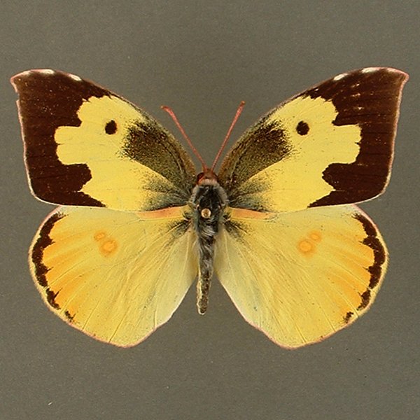
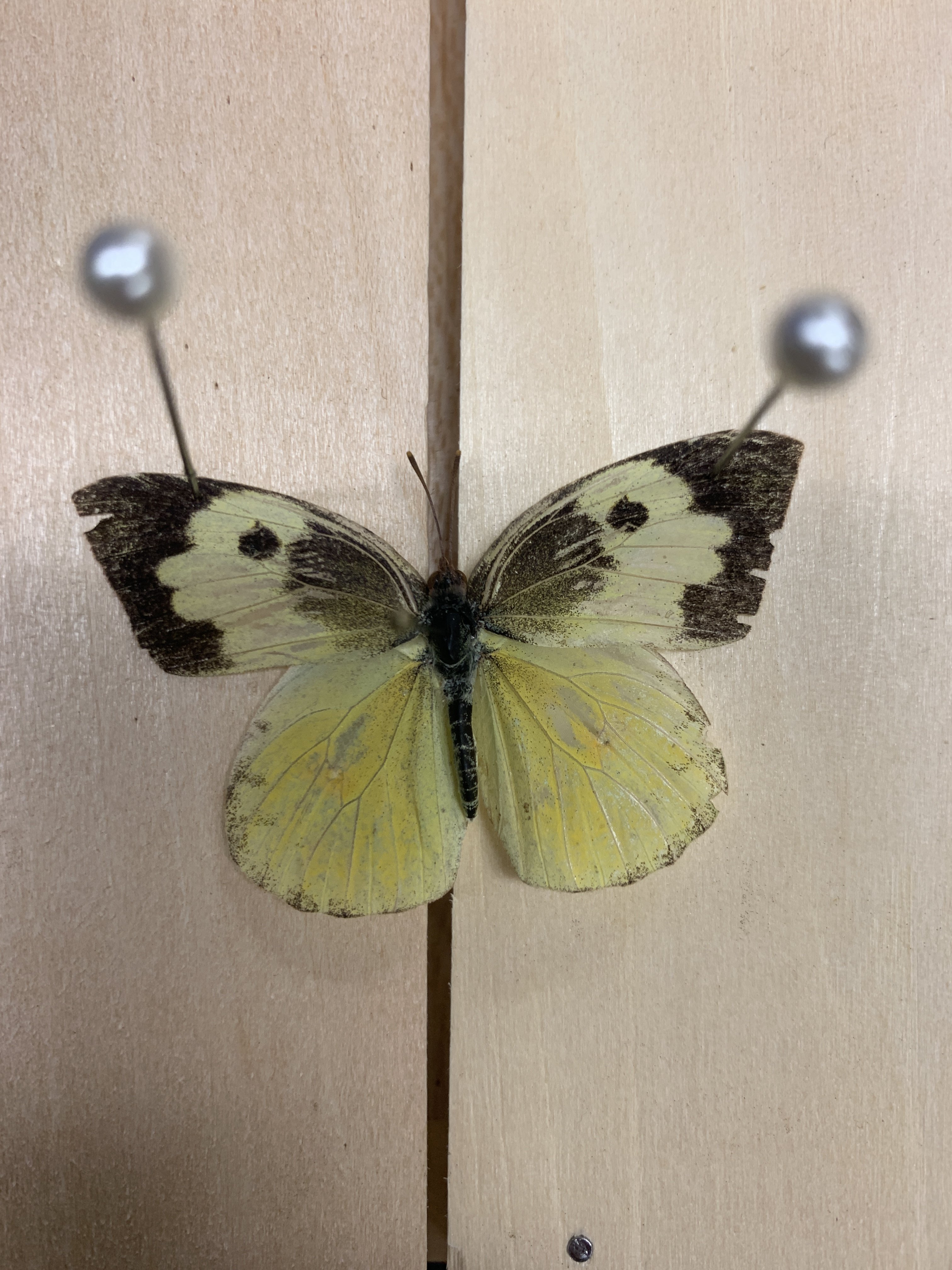
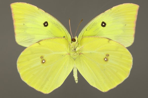
Wing span: 6.0 to 7.5 cm.
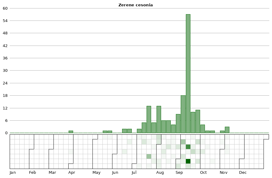
Flight time: First migrants begin appearing by early-mid June in most years, establishing two broods later in the season, one flying late July-mid August, and the second from September-October.
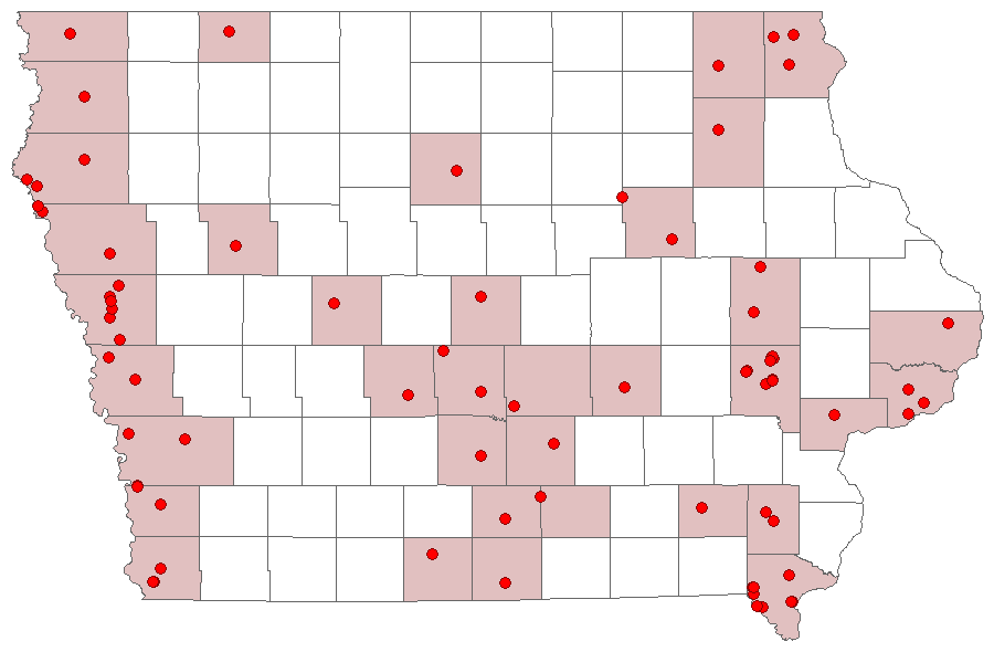
Status: Spring and early summer southern stray; summer resident.
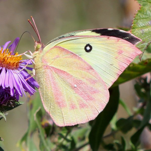
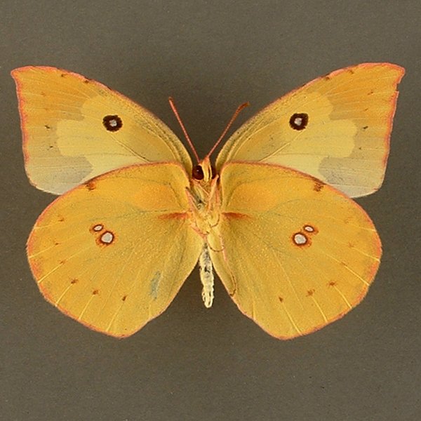
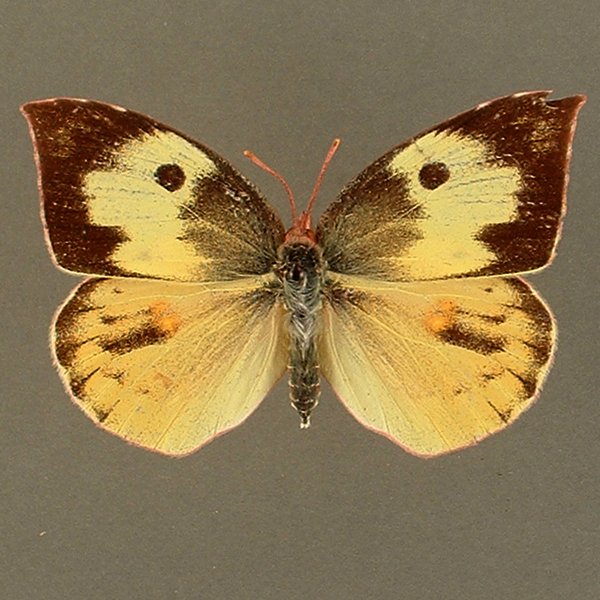
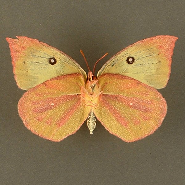
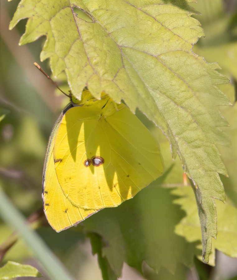
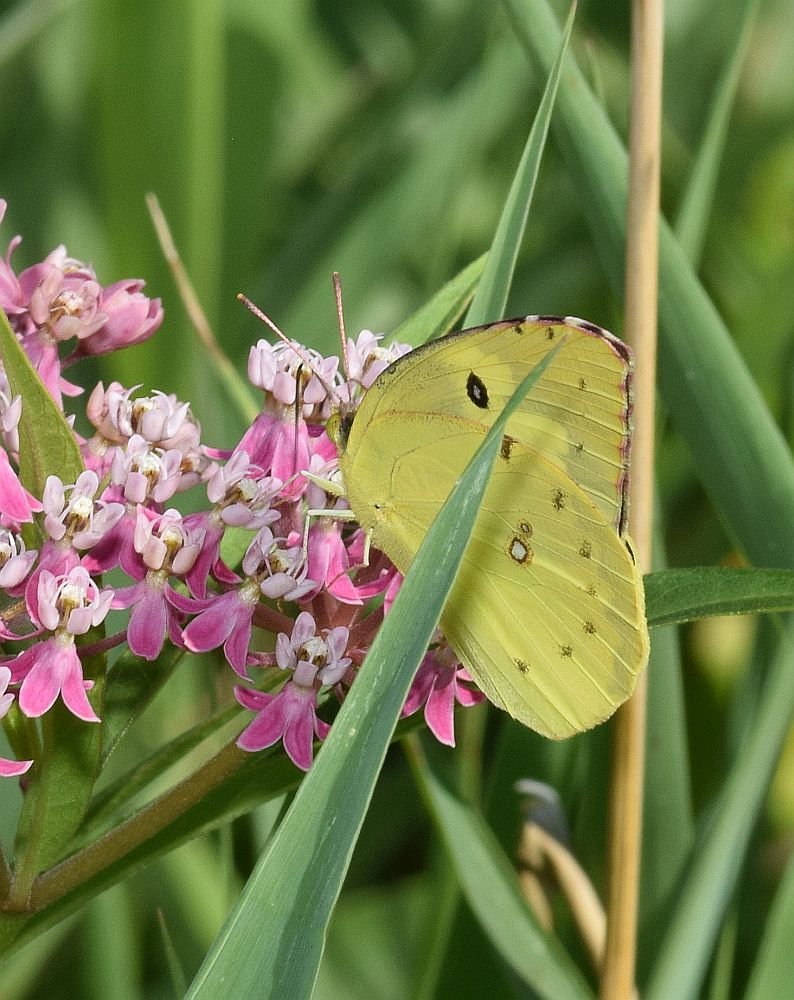
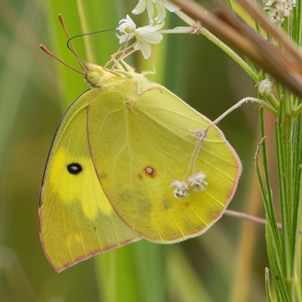
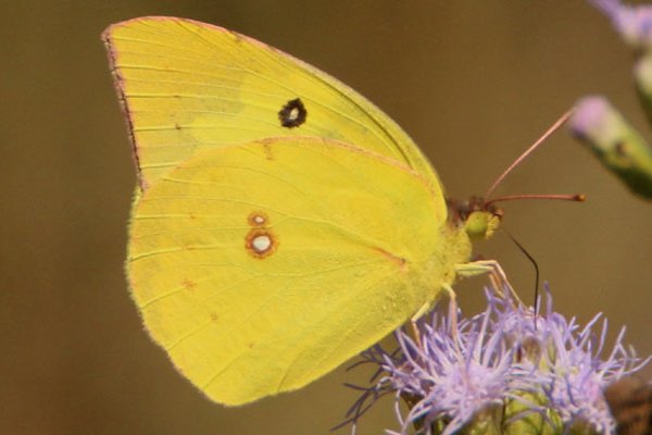
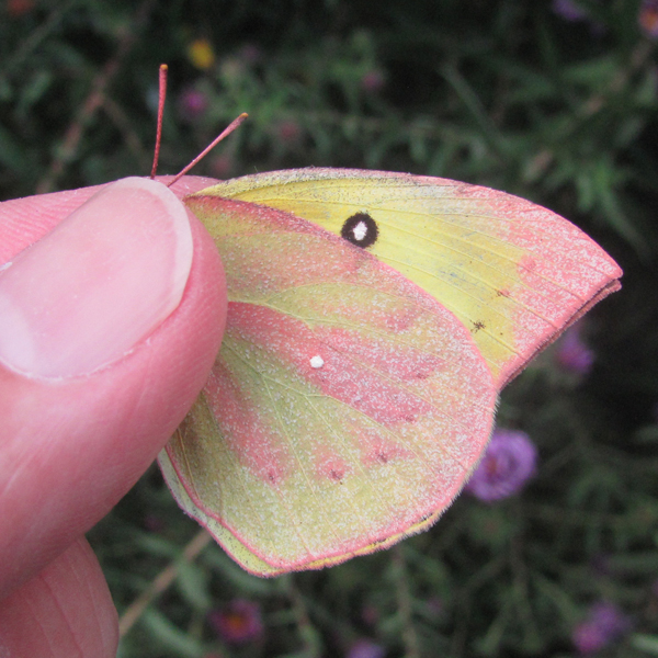
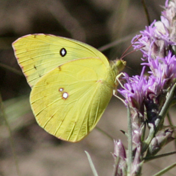
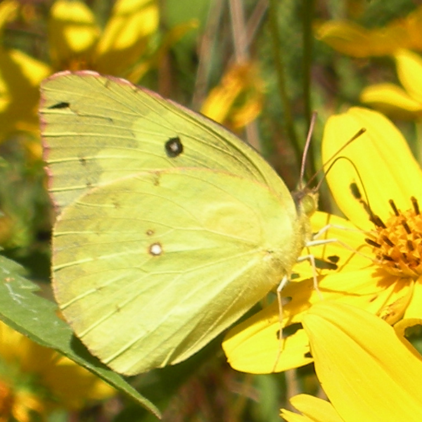
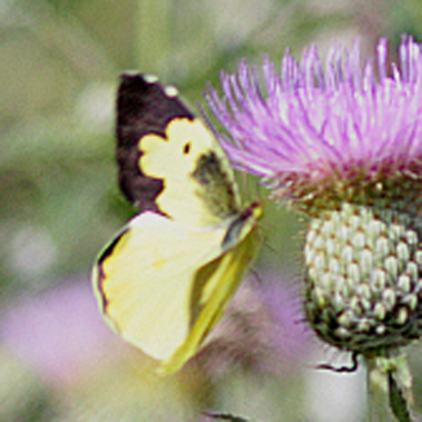
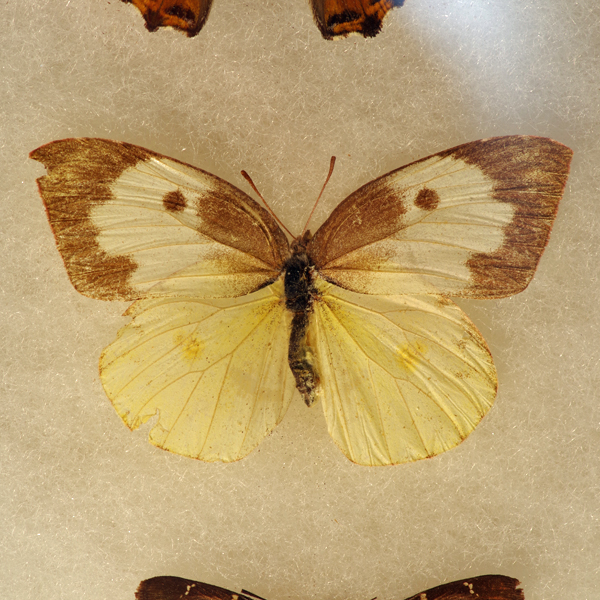
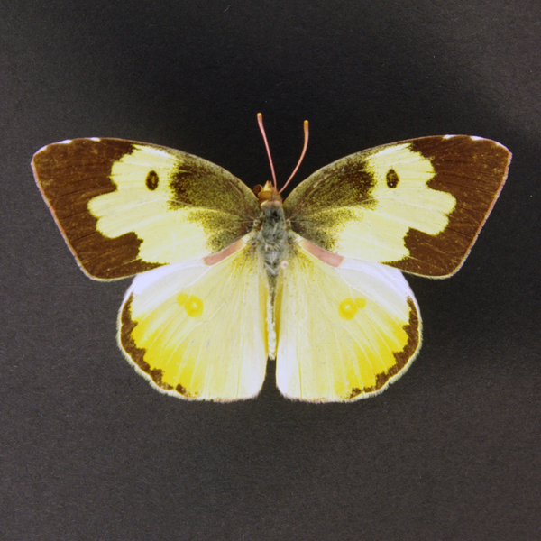
Distinguishing features: The dogface is named for the yellow dog's face (including an eye) framed in the black border of the upper, forewing surface. Wings are yellow below. Late autumn specimens may show a rosy cast to the underside, and have been referred to as the form rosa.
Distribution and habitat: Frequently found in the Loess Hills, it is incidental throughout the rest of the state. Individuals demonstrate a strong preference for dry meadows and prairies.
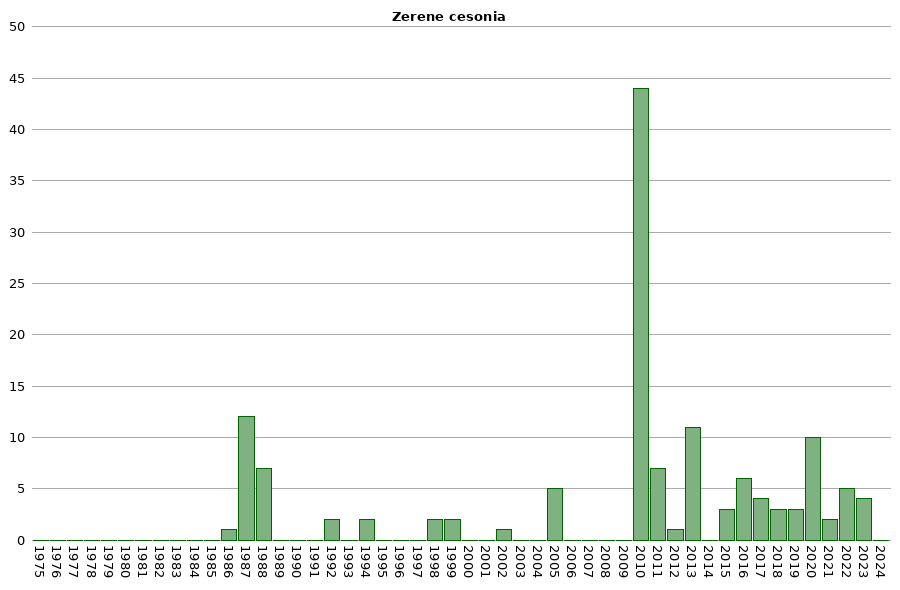
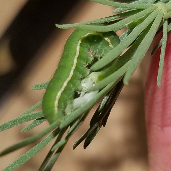
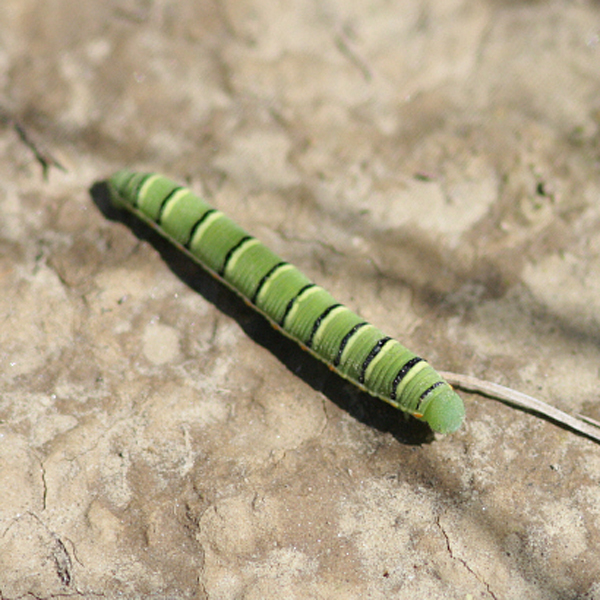
Natural History: Larvae feed on a large number of legumes, including the native leadplant, prairie clover, and false indigo. Adults, larvae, and eggs are unable to withstand harsh Iowa winters, and this species must repopulate the state each year via migration from the south. Because of this, population sizes may fluctuate greatly on a yearly basis.


| Record # | Date | Locale | State | Lat/Lon | Collected By | Count |
|---|---|---|---|---|---|---|
| 346941 | 2023-08-05 | Folsom Point Preserve | Iowa | 41.154432 -95.799393 | Jay Gilliam | 2 |
 346383 346383
|
2023-07-30 | Folsom Point Preserve | Iowa | 41.154432 -95.799393 | Jay Gilliam | 1 |
| 346452 | 2023-05-21 | Folsom Point Preserve | Iowa | 41.154432 -95.799393 | Jay Gilliam | 1 |
 312954 312954
|
2022-08-04 | Big Creek State Park | Iowa | 41.83495 -93.75494 | Harlan Ratcliff | 1 |
 318284 318284
|
2022-07-31 | Folsom Point Preserve | Iowa | 41.154432 -95.799393 | Jay Gilliam | 2 |
 319666 319666
|
2022-07-31 | Folsom Point Preserve | Iowa | 41.154432 -95.799393 | Jay Gilliam | 2 |
| 302993 | 2021-07-25 | Central College Field Station | Iowa | 41.368123 -93.01636 | IBSN | 1 |
| 302992 | 2021-07-08 | Sunderbruch Park | Iowa | 41.518191 -90.64319 | IBSN | 1 |
 276339 276339
|
2020-11-04 | National Butterfly Center | Texas | 26.179693 -98.366599 | Mark Brown | 1 |
| 286768 | 2020-09-19 | Waterworks Prairie Park, Iowa City | Iowa | 41.688035 -91.548556 | IBSN | 3 |
| 286767 | 2020-09-07 | Waterworks Prairie Park, Iowa City | Iowa | 41.688035 -91.548556 | IBSN | 2 |
| 275173 | 2020-09-04 | Waubonsie State Park | Iowa | 40.670911 -95.693287 | Jay Gilliam | 1 |
| 275166 | 2020-09-04 | Folsom Point Preserve | Iowa | 41.154432 -95.799393 | Jay Gilliam | 1 |
| 280530 | 2020-08-23 | Heron Bend Conservation Area | Iowa | 40.572222 -91.424444 | Chris Edwards | 1 |
| 286766 | 2020-07-22 | Waterworks Prairie Park, Iowa City | Iowa | 41.688035 -91.548556 | IBSN | 1 |
| 250916 | 2019-09-20 | Waterworks Prairie Park, Iowa City | Iowa | 41.689234 -91.551643 | IBSN | 2 |
 236765 236765
|
2019-08-22 | UNI Biomass Site | Iowa | 42.386423 -92.226086 | Chandler Dolan | 1 |
 287165 287165
|
2018-11-08 | Near Fairfield | Iowa | 41.050367 -92.023955 | Moni Hayne | 1 |
 287166 287166
|
2018-11-07 | Near Fairfield | Iowa | 41.050367 -92.023955 | Moni Hayne | 1 |
 287168 287168
|
2018-10-30 | Near Fairfield | Iowa | 41.050367 -92.023955 | Moni Hayne | 1 |
| 202765 | 2017-09-19 | Heron Bend Conservation Area | Iowa | 40.572222 -91.424444 | Chris Edwards | 2 |
| 199349 | 2017-08-08 | Heron Bend Conservation Area | Iowa | 40.5711 -91.4215 | Frank Olsen | 1 |
| 199464 | 2017-07-30 | Manikowski Prairie State Preserve | Iowa | 41.972843 -90.375383 | Frank Olsen | 1 |
| 181093 | 2016-09-24 | Heron Bend Conservation Area | Iowa | 40.5711 -91.4215 | Frank Olsen | 1 |
 177283 177283
|
2016-09-16 | Hitaga Sand Ridge Prairie Preserve | Iowa | 42.250957 -91.632098 | Frank Olsen | 1 |
| 181009 | 2016-09-15 | Hitaga Sand Ridge Prairie Preserve | Iowa | 42.250199 -91.634949 | Frank Olsen | 1 |
| 180794 | 2016-08-31 | Turin Loess Hills State Preserve | Iowa | 42.0455 -95.965 | Frank Olsen | 1 |
| 190787 | 2016-08-03 | Neal Smith National Wildlife Refuge | Iowa | 41.558683 -93.280422 | IBSN | 1 |
| 183978 | 2016-07-16 | MacBride Nature Recreation Area | Iowa | 41.786242 -91.566399 | Chris Edwards | 1 |
| 130994 | 2015-09-16 | Heron Bend Conservation Area | Iowa | 40.5711 -91.4215 | Frank Olsen | 3 |
| 6438 | 2013-07-20 | Lake MacBride State Park | Iowa | 41.795744 -91.545649 | BAMONA | 1 |
| 10426 | 2013-07-20 | Lake MacBride State Park | Iowa | 41.7955556 -91.545 | Tom Jantscher | 1 |
| 113052 | 2013-07-20 | Lake MacBride State Park | Iowa | 41.800146 -91.555669 | Chris Edwards | 7 |
 144120 144120
|
2013-07-20 | Lake MacBride State Park | Iowa | 41.804 -91.55133 | Mark Brown | 1 |
| 64420 | 2013-05-14 | Turkey Run Access | Iowa | 40.550592 -91.654215 | Frank Olsen | 1 |
| 64408 | 2012-10-03 | Heron Bend Conservation Area | Iowa | 40.5711 -91.4215 | Frank Olsen | 1 |
 208625 208625
|
2011-09-25 | Loess Hills Wildlife Management Area | Iowa | 42.08 -95.9765 | Aaron Brees | 1 |
| 7574 | 2011-09-25 | Sylvan Runkel State Preserve | Iowa | 42.105 -95.98233 | Aaron Brees | 1 |
| 246510 | 2011-09-25 | Preparation Canyon State Park | Iowa | 41.89133 -95.91407 | Aaron Brees | 2 |
| 10425 | 2011-07-30 | F. W. Kent Park | Iowa | 41.7352778 -91.7225 | Tom Jantscher | 1 |
| 113051 | 2011-07-30 | F. W. Kent Park | Iowa | 41.72916 -91.727161 | Chris Edwards | 1 |
| 6446 | 2011-07-28 | Stephens State Forest - Thousand Acre Unit, Lucas County | Iowa | 41.103003 -93.101751 | BAMONA | 1 |
 208627 208627
|
2010-09-29 | Folsom Point Preserve | Iowa | 41.16139 -95.795 | Aaron Brees | 1 |
| 7571 | 2010-09-29 | Loess Hills Wildlife Management Area | Iowa | 42.159722 -95.92676 | Aaron Brees | 3 |
| 64409 | 2010-09-20 | Heron Bend Conservation Area | Iowa | 40.5711 -91.4215 | Frank Olsen | 1 |
| 6440 | 2010-09-12 | Heron Bend Conservation Area | Iowa | 40.5719385 -91.420817 | BAMONA | 15 |
 208626 208626
|
2010-09-12 | Loess Hills State Forest, Little Sioux Unit | Iowa | 41.80231 -95.98757 | Aaron Brees | 4 |
| 10429 | 2010-09-12 | Shimek State Forest, Donnellson Unit | Iowa | 40.6463889 -91.6863889 | Tom Jantscher | 1 |
 108974 108974
|
2010-09-12 | Heron Bend Conservation Area | Iowa | 40.5722222 -91.4244444 | Tom Jantscher | 1 |
 138211 138211
|
2010-09-04 | Folsom Point Preserve | Iowa | 41.159374 -95.79696 | Aaron Brees | 10 |
 208628 208628
|
2010-08-29 | Folsom Point Preserve | Iowa | 41.16139 -95.795 | Aaron Brees | 4 |
| 10427 | 2010-08-15 | Heron Bend Conservation Area | Iowa | 40.5722222 -91.4244444 | Tom Jantscher | 2 |
| 113050 | 2010-08-15 | Heron Bend Conservation Area | Iowa | 40.572222 -91.424444 | Chris Edwards | 2 |
| 64410 | 2005-09-12 | Hitchcock Nature Center | Iowa | 41.41733 -95.85388 | Frank Olsen | 1 |
| 64421 | 2005-09-02 | Winneshiek County | Iowa | 43.23626 -91.90993 | 1 | |
| 354438 | 2005-09-02 | Decorah Community Prairie | Iowa | 43.3015 -91.8025 | Ryan Hahn | 1 |
| 354439 | 2005-09-02 | Decorah Community Prairie | Iowa | 43.3015 -91.8025 | Derek Broman | 1 |
 49744 49744
|
2005-08-06 | Shimek State Forest, Lick Creek Unit | Iowa | 40.612832 -91.676971 | Jim Durbin | 1 |
| 113049 | 2002-08-10 | Heron Bend Conservation Area | Iowa | 40.572222 -91.424444 | Chris Edwards | 1 |
| 113048 | 1999-07-10 | Heron Bend Conservation Area | Iowa | 40.572222 -91.424444 | Chris Edwards | 2 |
| 113053 | 1998-09-27 | Shimek State Forest, Donnellson Unit | Iowa | 40.643603 -91.67741 | Chris Edwards | 2 |
| 64400 | 1994-06-14 | Cedar Hills Sand Prairie Preserve | Iowa | 42.59305 -92.55315 | Ed Freese | 2 |
| 64401 | 1992-06-18 | Five Ridge Prairie State Preserve | Iowa | 42.67867 -96.53473 | Ron Harms | 2 |
| 108052 | 1988-10-09 | Huser's Prairie | Iowa | 42.650399 -96.468816 | Tim Orwig | 1 |
| 108051 | 1988-10-01 | Huser's Prairie | Iowa | 42.650399 -96.468816 | Tim Orwig | 1 |
| 108050 | 1988-08-20 | Huser's Prairie | Iowa | 42.650399 -96.468816 | Tim Orwig | 1 |
| 64418 | 1988-08-17 | Sioux City State Prairie Preserve | Iowa | 42.5241 -96.4362 | Tim Orwig | 1 |
 144210 144210
|
1988-07-26 | Waubonsie State Park | Iowa | 40.676 -95.689 | Frank Olsen | 1 |
| 108049 | 1988-07-08 | Huser's Prairie | Iowa | 42.650399 -96.468816 | Tim Orwig | 1 |
| 64419 | 1988-07-01 | Stone State Park | Iowa | 42.55333 -96.46194 | Tim Orwig | 1 |
| 64407 | 1987-10-04 | Hanover Township | Iowa | 43.37643 -91.54023 | J. Nehuevaj | 1 |
| 358461 | 1987-10-04 | Riverside Drive | Iowa | 43.427167 -91.52 | John G. Nehnevaj | 1 |
| 64417 | 1987-09-13 | Sioux City State Prairie Preserve | Iowa | 42.5241 -96.4362 | Tim Orwig | 1 |
| 64403 | 1987-09-07 | French Creek Wildlife Management Area | Iowa | 43.39075 -91.412 | J. Nehuevaj | 1 |
| 355173 | 1987-09-07 | French Creek Township | Iowa | 43.391486 -91.436751 | John G. Nehnevaj | 1 |
| 355174 | 1987-09-07 | French Creek Township | Iowa | 43.391486 -91.436751 | John G. Nehnevaj | 1 |
| 358844 | 1987-09-07 | Sunflower Drive Hill Prairie | Iowa | 43.387 -91.456 | John G. Nehnevaj | 1 |
| 64406 | 1987-08-09 | Hanover Township | Iowa | 43.37643 -91.54023 | J. Nehuevaj | 1 |
| 358576 | 1987-08-09 | Mile Long Prairie | Iowa | 43.4065 -91.563833 | John G. Nehnevaj | 1 |
| 358577 | 1987-08-09 | Mile Long Prairie | Iowa | 43.4065 -91.563833 | John G. Nehnevaj | 1 |
| 64405 | 1987-07-10 | French Creek Wildlife Management Area | Iowa | 43.39075 -91.412 | J. Nehuevaj | 1 |
| 358845 | 1987-07-10 | Sunflower Drive Hill Prairie | Iowa | 43.387 -91.456 | John G. Nehnevaj | 1 |
| 64416 | 1986-09-23 | Sioux City State Prairie Preserve | Iowa | 42.5241 -96.4362 | Tim Orwig | 1 |
| 64415 | 1969-07-22 | Davenport | Iowa | 41.57532 -90.54219 | St. Ambrose Univ. | 1 |
| 64412 | 1969-07-20 | Shimek State Forest, Croton Unit East | Iowa | 40.54575 -91.61623 | St. Ambrose Univ. | 1 |
| 64411 | 1967-07-30 | Shimek State Forest, Croton Unit East | Iowa | 40.54575 -91.61623 | St. Ambrose Univ. | 1 |
| 64414 | 1965-08-20 | Davenport | Iowa | 41.57532 -90.54219 | St. Ambrose Univ. | 1 |
 144560 144560
|
1959-09-02 | Indian Bluff Golf Course | Illinois | 41.434718 -90.510185 | Frank Olsen | 1 |
 144550 144550
|
1957-10-20 | Moline | Illinois | 41.486159 -90.499175 | Frank Olsen | 1 |
| 6428 | 1950-09-15 | Allamakee County | Iowa | 43.243076 -91.443466 | USGS - NPWRC | 1 |
| 6429 | 1950-09-15 | Dallas County | Iowa | 41.612003 -93.987846 | USGS - NPWRC | 1 |
| 6430 | 1950-09-15 | Decatur County | Iowa | 40.814648 -93.824821 | USGS - NPWRC | 1 |
| 6431 | 1950-09-15 | Dickinson County | Iowa | 43.404938 -95.184921 | USGS - NPWRC | 1 |
| 6432 | 1950-09-15 | Fayette County | Iowa | 42.925819 -91.909927 | USGS - NPWRC | 1 |
| 6433 | 1950-09-15 | Sidney | Iowa | 40.74004 -95.645798 | USGS - NPWRC | 1 |
| 6434 | 1950-09-15 | Greene County | Iowa | 42.070053 -94.479973 | USGS - NPWRC | 1 |
| 6435 | 1950-09-15 | Harrison County | Iowa | 41.693386 -95.814285 | USGS - NPWRC | 1 |
| 6436 | 1950-09-15 | Henry County | Iowa | 41.028358 -91.598396 | USGS - NPWRC | 1 |
| 6437 | 1950-09-15 | Johnson County | Iowa | 41.669899 -91.598396 | USGS - NPWRC | 1 |
| 6439 | 1950-09-15 | Lee County | Iowa | 40.706867 -91.443466 | USGS - NPWRC | 1 |
| 6441 | 1950-09-15 | Linn County | Iowa | 42.027289 -91.67275 | USGS - NPWRC | 1 |
| 6442 | 1950-09-15 | Lucas County | Iowa | 40.991203 -93.33889 | USGS - NPWRC | 1 |
| 6443 | 1950-09-15 | Lyon County | Iowa | 43.3936 -96.2479 | USGS - NPWRC | 1 |
| 6444 | 1950-09-15 | Mills County | Iowa | 41.06245 -95.645798 | USGS - NPWRC | 1 |
| 6445 | 1950-09-15 | Monona County | Iowa | 42.001595 -95.983261 | USGS - NPWRC | 1 |
| 6447 | 1950-09-15 | Muscatine County | Iowa | 41.51569 -91.1353 | USGS - NPWRC | 1 |
| 6448 | 1950-09-15 | Plymouth County | Iowa | 42.776665 -96.152695 | USGS - NPWRC | 1 |
| 6449 | 1950-09-15 | Polk County | Iowa | 41.627842 -93.500343 | USGS - NPWRC | 1 |
| 6450 | 1950-09-15 | Pottawattamie County | Iowa | 41.391151 -95.477783 | USGS - NPWRC | 1 |
| 6451 | 1950-09-15 | Poweshiek County | Iowa | 41.653011 -92.539604 | USGS - NPWRC | 1 |
| 6452 | 1950-09-15 | Sac County | Iowa | 42.357353 -95.143204 | USGS - NPWRC | 1 |
| 6453 | 1950-09-15 | Scott County | Iowa | 41.63932 -90.639374 | USGS - NPWRC | 1 |
| 6454 | 1950-09-15 | Sioux County | Iowa | 43.086994 -96.152695 | USGS - NPWRC | 1 |
| 6455 | 1950-09-15 | Story County | Iowa | 42.104046 -93.500343 | USGS - NPWRC | 1 |
| 6456 | 1950-09-15 | Warren County | Iowa | 41.308056 -93.500343 | USGS - NPWRC | 1 |
| 6457 | 1950-09-15 | Wayne County | Iowa | 40.667736 -93.33889 | USGS - NPWRC | 1 |
| 6458 | 1950-09-15 | Winneshiek County | Iowa | 43.236259 -91.909927 | USGS - NPWRC | 1 |
| 6459 | 1950-09-15 | Woodbury County | Iowa | 42.316616 -95.983261 | USGS - NPWRC | 1 |
| 6460 | 1950-09-15 | Wright County | Iowa | 42.727375 -93.662323 | USGS - NPWRC | 1 |
| 108046 | 1944-08-13 | Mount Pleasant | Iowa | 40.982369 -91.542799 | 1 | |
| 108048 | 1938-07-28 | Dickinson County, Iowa | Iowa | Location Protected | 1 | |
| 64413 | 1933-03-29 | Polk County | Iowa | 41.6278 -93.50034 | 1 |