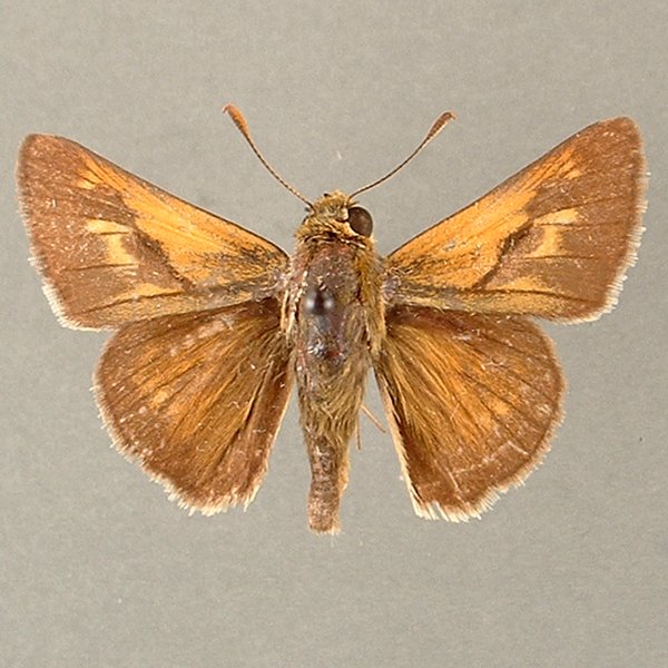
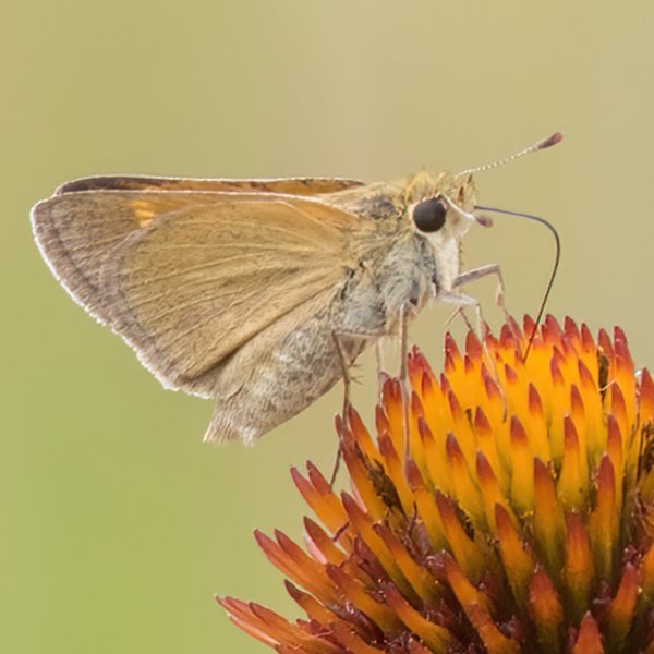
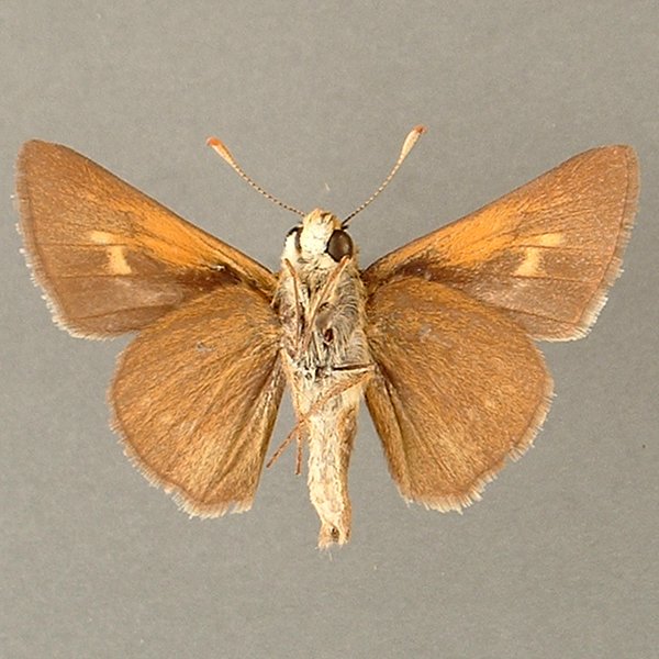
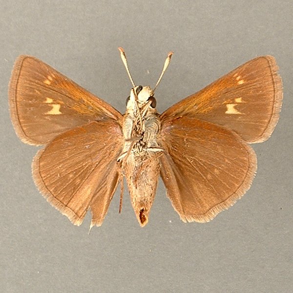
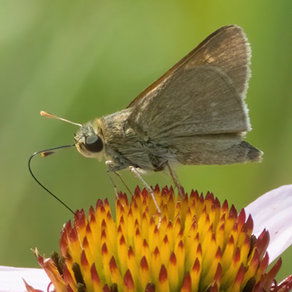
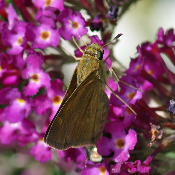
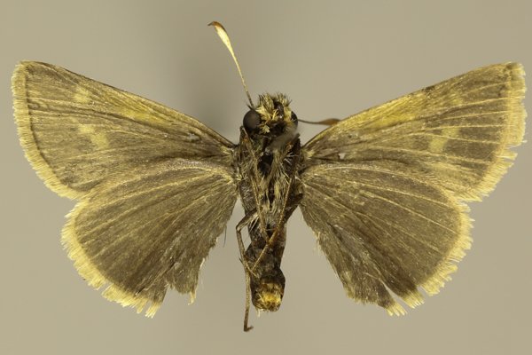
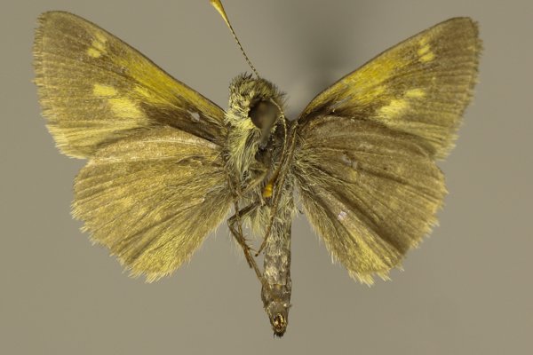
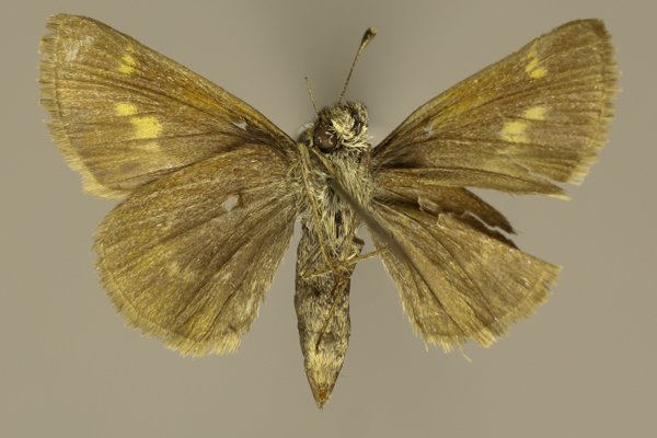
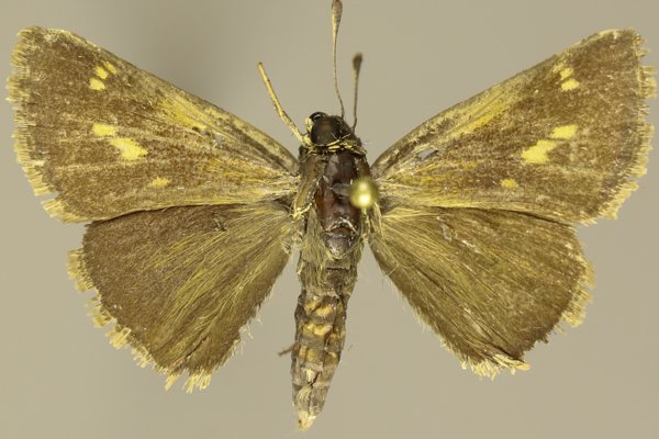
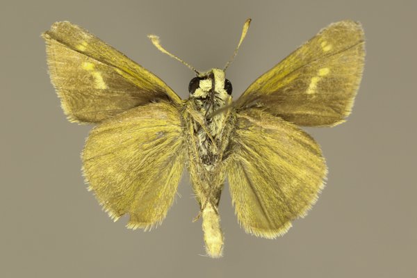
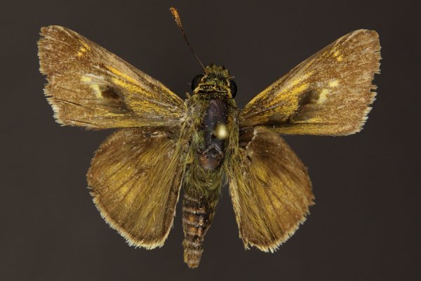
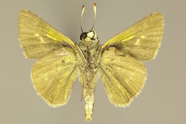
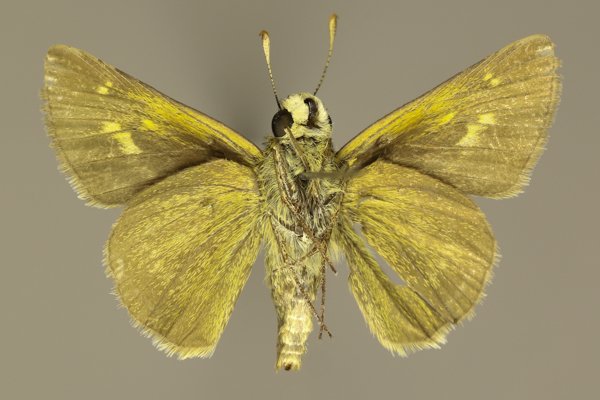
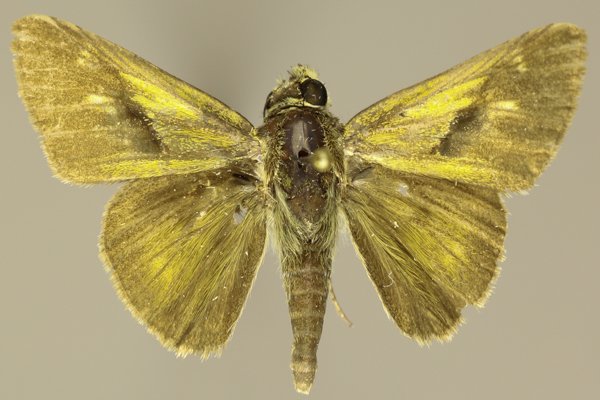
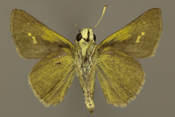
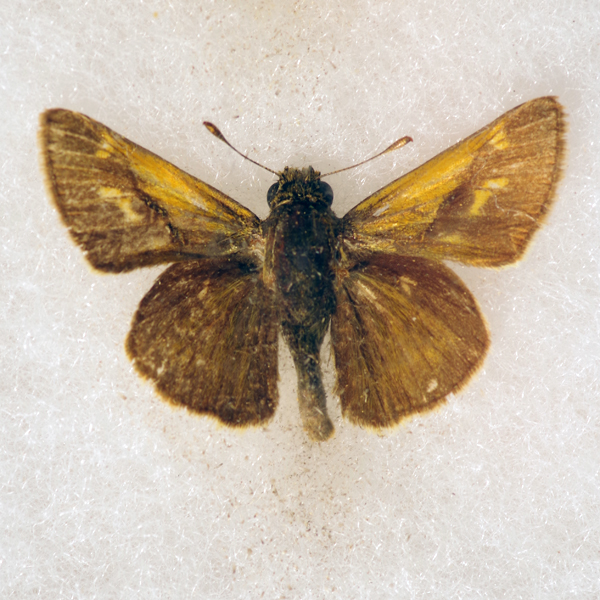
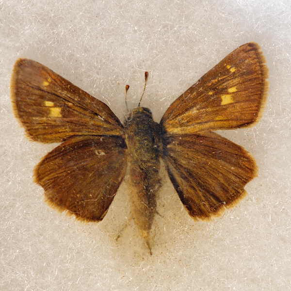
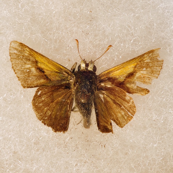
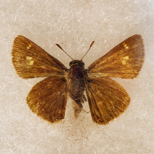
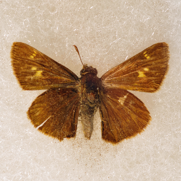
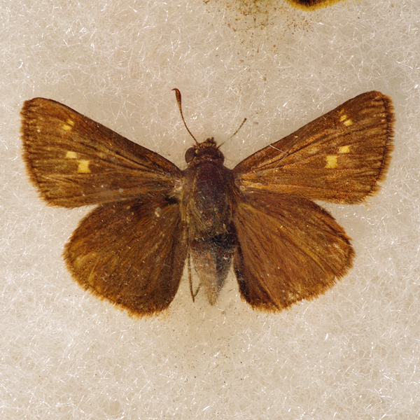
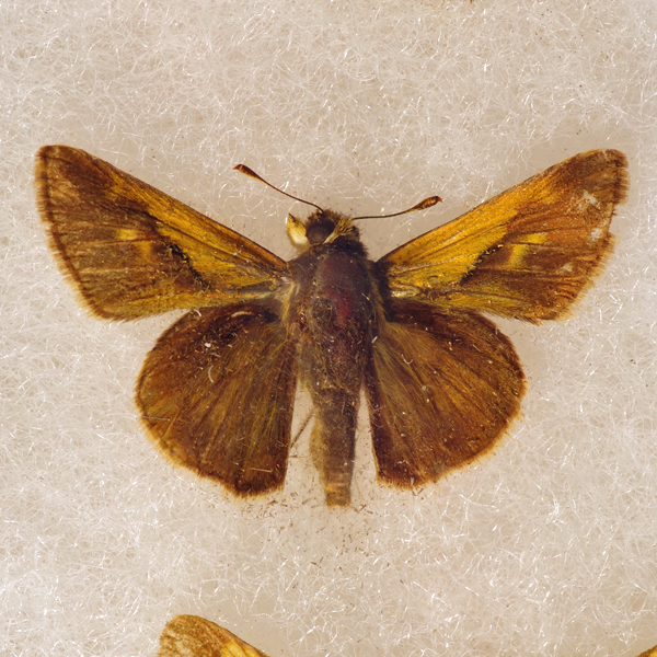
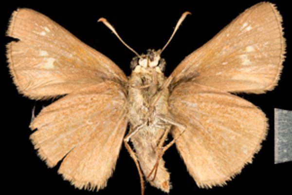
Wing span: 2.6-3.3 cm.
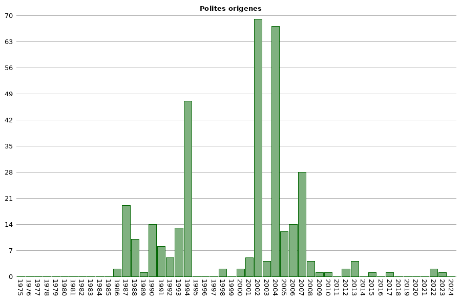
Flight time: Adults are univoltine, with flight occurring from mid June to the end of July.
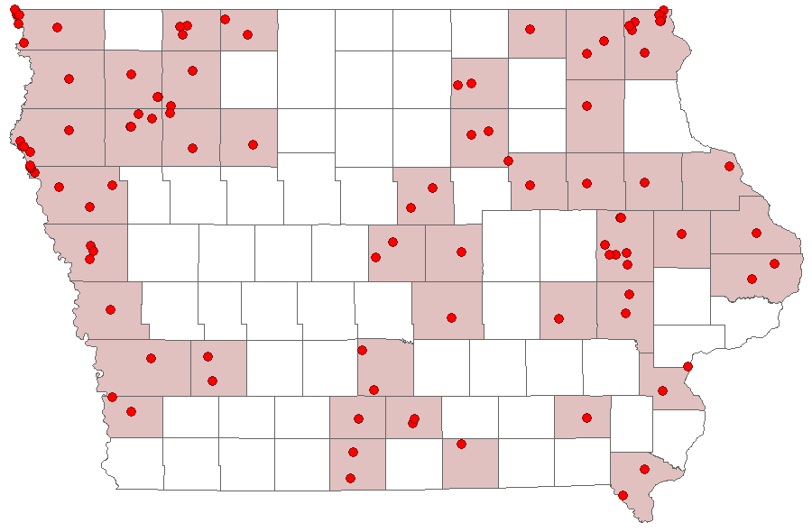
Status: Infrequent breeding resident.
Distinguishing features: The Crossline Skipper is superficially similar to the Tawny Edged skipper (P. themistocles) except it is larger. The stigma in the male is less well defined than on P. themistocles with the lower edge fading to brown. The female is dark brown with a row of spots on the forewing above, similar to P. themistocles, which often has blurred distal edges. The largest spot is often tan. Individuals of P. origenes and P. themistocles can be difficult to tell apart but differences are clearer when comparing to a series of specimens.
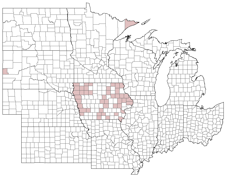
Distribution and habitat: The Cross Line Skipper is essentially limited to dry native prairie tracts. It thrives in the Loess Hill in the west and limestone glades and sand prairies in the east. It has also been found on dry prairies in southern and central Iowa, and from xeric gravel prairies in the northwest.
Natural History: The only reported larval host, Purpletop Grass (Tridens flavus), is uncommon in Iowa and limited to disturbed sand prairies in the southeast. Clearly other native dry prairie grasses must be consumed.


| Record # | Date | Locale | State | Lat/Lon | Collected By | Count |
|---|---|---|---|---|---|---|
 342416 342416
|
2023-05-28 | Rolling Thunder Prairie State Preserve | Iowa | 41.199808908333 -93.655166968333 | Mark Brown | 1 |
 318090 318090
|
2022-06-30 | Five Ridge Prairie State Preserve | Iowa | 42.679143 -96.523488 | Jay Gilliam | 1 |
 317956 317956
|
2022-06-18 | Folsom Point Preserve | Iowa | 41.154432 -95.799393 | Jay Gilliam | 1 |
 194893 194893
|
2017-08-01 | 1460 Douglas Ct, Marion | Iowa | 42.040069 -91.590953 | Jim Durbin | 1 |
| 130915 | 2015-07-10 | Armund Bartz Prairie | Iowa | 43.429728 -91.310705 | Frank Olsen | 1 |
| 61212 | 2013-07-28 | Wickiup Hill Outdoor Learning Area | Iowa | 42.08398 -91.7651 | Frank Olsen | 1 |
| 61179 | 2013-07-04 | Manikowski Prairie State Preserve | Iowa | 41.972843 -90.375383 | Frank Olsen | 3 |
| 7276 | 2012-07-04 | Five Ridge Prairie State Preserve | Iowa | 42.67867 -96.53473 | Aaron Brees | 1 |
| 61184 | 2012-06-22 | Pohlman Prairie | Iowa | 42.561448 -90.745365 | Frank Olsen | 1 |
| 61167 | 2010-06-16 | Indiangrass Hills | Iowa | 41.63778 -92.14389 | Frank Olsen | 1 |
| 7275 | 2009-07-11 | Slip Bluff County Park | Iowa | 40.65255 -93.84534 | Aaron Brees | 1 |
| 61166 | 2008-08-27 | Indiangrass Hills | Iowa | 41.63778 -92.14389 | Frank Olsen | 1 |
| 61169 | 2008-08-16 | Indiangrass Hills | Iowa | 41.63778 -92.14389 | Frank Olsen | 1 |
| 61168 | 2008-07-03 | Indiangrass Hills | Iowa | 41.63778 -92.14389 | Frank Olsen | 1 |
| 61174 | 2008-06-24 | Manikowski Prairie State Preserve | Iowa | 41.972843 -90.375383 | Frank Olsen | 1 |
| 141400 | 2007-09-26 | Reiman Gardens Area, Ames | Iowa | 42.01102 -93.638089 | Nathan Brockman | 4 |
| 141374 | 2007-09-12 | Reiman Gardens Area, Ames | Iowa | 42.01102 -93.638089 | Nathan Brockman | 5 |
| 61178 | 2007-07-30 | Manikowski Prairie State Preserve | Iowa | 41.972843 -90.375383 | Frank Olsen | 2 |
| 61182 | 2007-07-21 | Manikowski Prairie State Preserve | Iowa | 41.972843 -90.375383 | Frank Olsen | 1 |
| 61175 | 2007-07-11 | Manikowski Prairie State Preserve | Iowa | 41.972843 -90.375383 | Frank Olsen | 1 |
| 61192 | 2007-07-06 | Rock Island Botanical State Preserve | Iowa | 42.02732 -91.72723 | Frank Olsen | 3 |
| 61181 | 2007-07-01 | Manikowski Prairie State Preserve | Iowa | 41.972843 -90.375383 | Frank Olsen | 9 |
| 61137 | 2007-06-23 | Cayler Prairie State Preserve | Iowa | 43.3972 -95.2459 | Frank Olsen | 1 |
| 61138 | 2007-06-23 | Cayler Prairie State Preserve | Iowa | 43.3972 -95.2459 | Frank Olsen | 1 |
| 61147 | 2007-06-19 | Rockford Fossil & Prairie Park Preserve | Iowa | 43.04778 -92.97113 | Frank Olsen | 1 |
| 61129 | 2006-08-27 | Blue Flag Marsh | Iowa | 41.441 -93.75533 | Frank Olsen | 2 |
| 61128 | 2006-08-16 | Blue Flag Marsh | Iowa | 41.441 -93.75533 | Frank Olsen | 1 |
| 61148 | 2006-07-27 | Rockford Fossil & Prairie Park Preserve | Iowa | 43.04778 -92.97113 | Frank Olsen | 1 |
| 61149 | 2006-07-10 | Rockford Fossil & Prairie Park Preserve | Iowa | 43.04778 -92.97113 | Frank Olsen | 2 |
| 357293 | 2006-06-27 | Little Elk Creek Canyon | South Dakota | 44.24 -103.461111 | Kirk J. Larsen | 1 |
| 118193 | 2006-06-24 | Shimek State Forest, Croton Unit East | Iowa | 40.545896 -91.616881 | Chris Edwards | 1 |
 42948 42948
|
2006-06-17 | Golden Eagle Lodge | Minnesota | 48.05537 -90.39812 | Jim Durbin | 1 |
 42949 42949
|
2006-06-17 | Golden Eagle Lodge | Minnesota | 48.05537 -90.39812 | Jim Durbin | 1 |
 42950 42950
|
2006-06-17 | Golden Eagle Lodge | Minnesota | 48.05537 -90.39812 | Jim Durbin | 1 |
 42951 42951
|
2006-06-17 | Golden Eagle Lodge | Minnesota | 48.05537 -90.39812 | Jim Durbin | 1 |
 42946 42946
|
2006-05-29 | Leon's Farm, Ohio County | Kentucky | 37.42033 -86.77023 | Jim Durbin | 1 |
 42947 42947
|
2006-05-29 | Leon's Farm, Ohio County | Kentucky | 37.42033 -86.77023 | Jim Durbin | 1 |
| 61204 | 2005-08-30 | Steele Prairie State Preserve West | Iowa | 42.876134 -95.580237 | Jerry Selby | 1 |
| 61183 | 2005-07-06 | Martin Area County Park | Iowa | 42.850077 -95.471232 | Frank Olsen | 4 |
| 61122 | 2005-07-05 | Anderson Prairie State Preserve, Emmet County | Iowa | 43.441 -94.8724 | Dennis Schlicht | 1 |
| 61123 | 2005-07-05 | Anderson Prairie State Preserve, Emmet County | Iowa | 43.441 -94.8724 | Frank Olsen | 1 |
| 61150 | 2005-06-30 | Freda Haffner Kettlehole State Preserve | Iowa | 43.349034 -95.222697 | Jerry Selby | 1 |
 42942 42942
|
2005-06-06 | Leon's Farm, Ohio County | Kentucky | 37.42033 -86.77023 | Jim Durbin | 1 |
 42943 42943
|
2005-06-06 | Leon's Farm, Ohio County | Kentucky | 37.42033 -86.77023 | Jim Durbin | 1 |
 42944 42944
|
2005-06-06 | Leon's Farm, Ohio County | Kentucky | 37.42033 -86.77023 | Jim Durbin | 1 |
 42962 42962
|
2005-06-06 | Leon's Farm, Ohio County | Kentucky | 37.42033 -86.77023 | Jim Durbin | 1 |
| 118197 | 2004-07-17 | MacBride Nature Recreation Area | Iowa | 41.786242 -91.566399 | Chris Edwards | 3 |
| 61139 | 2004-07-10 | Cayler Prairie State Preserve | Iowa | 43.3972 -95.2459 | Jerry Selby | 1 |
| 107675 | 2004-07-10 | Steele Prairie State Preserve West | Iowa | 42.876238 -95.58001 | Jerry Selby | 2 |
| 61153 | 2004-07-09 | Glacial Hills Preserve, Nature Conservancy | Iowa | 42.88367 -95.32233 | Frank Olsen | 19 |
| 61154 | 2004-07-09 | Glacial Hills Preserve, Nature Conservancy | Iowa | 42.88367 -95.32233 | Jerry Selby | 10 |
| 61158 | 2004-07-08 | Hidden Bridge Wildlife Area | Iowa | 43.415681 -96.563796 | Frank Olsen | 8 |
| 61134 | 2004-07-07 | Blood Run Preserve | Iowa | 43.46638 -96.57861 | Frank Olsen | 3 |
| 61151 | 2004-07-07 | Gitchie Manitou State Preserve | Iowa | 43.4997 -96.5983 | Frank Olsen | 1 |
| 61159 | 2004-07-07 | Hidden Bridge Wildlife Area | Iowa | 43.415681 -96.563796 | Frank Olsen | 1 |
| 61124 | 2004-07-05 | Anderson Prairie State Preserve, Emmet County | Iowa | 43.441 -94.8724 | Jerry Selby | 1 |
| 61132 | 2004-07-04 | Bertram Reservation | Iowa | 42.926646 -95.314272 | Jerry Selby | 2 |
| 107676 | 2004-07-04 | Steele Prairie State Preserve West | Iowa | 42.876238 -95.58001 | Jerry Selby | 3 |
| 61130 | 2004-06-30 | Bertram Reservation | Iowa | 42.926646 -95.314272 | Frank Olsen | 2 |
| 61131 | 2004-06-30 | Bertram Reservation | Iowa | 42.926646 -95.314272 | Jerry Selby | 2 |
| 61155 | 2004-06-30 | Glacial Hills Preserve, Nature Conservancy | Iowa | 42.88367 -95.32233 | Jerry Selby | 6 |
| 61125 | 2004-06-28 | Anderson Prairie State Preserve, Emmet County | Iowa | 43.441 -94.8724 | Frank Olsen | 2 |
| 61176 | 2004-06-22 | Manikowski Prairie State Preserve | Iowa | 41.972843 -90.375383 | Frank Olsen | 1 |
| 61177 | 2003-07-25 | Manikowski Prairie State Preserve | Iowa | 41.972843 -90.375383 | Frank Olsen | 3 |
| 61161 | 2003-07-12 | Hitaga Sand Ridge Prairie Preserve | Iowa | 42.25233 -91.63633 | Frank Olsen | 1 |
| 61201 | 2002-08-09 | Rock Island Botanical State Preserve | Iowa | 42.02732 -91.72723 | Frank Olsen | 1 |
| 61163 | 2002-07-23 | Honey Creek State Park | Iowa | 40.86526 -92.94011 | Dennis Schlicht | 1 |
| 61185 | 2002-07-23 | Rock Island Botanical State Preserve | Iowa | 42.02732 -91.72723 | Dennis Schlicht | 1 |
| 61193 | 2002-07-23 | Rock Island Botanical State Preserve | Iowa | 42.02732 -91.72723 | Frank Olsen | 4 |
| 144206 | 2002-07-20 | Wolter's Prairie Preserve | Iowa | 42.772816 -92.71669 | Frank Olsen | 1 |
| 118196 | 2002-07-19 | MacBride Nature Recreation Area | Iowa | 41.786242 -91.566399 | Chris Edwards | 1 |
| 61191 | 2002-07-15 | Rock Island Botanical State Preserve | Iowa | 42.02732 -91.72723 | Frank Olsen | 1 |
| 144528 | 2002-07-15 | Rock Island Botanical State Preserve | Iowa | 42.026205 -91.726516 | Frank Olsen | 3 |
| 61186 | 2002-07-12 | Rock Island Botanical State Preserve | Iowa | 42.02732 -91.72723 | Dennis Schlicht | 1 |
| 271808 | 2002-07-12 | Rock Island Botanical State Preserve | Iowa | 42.02732 -91.72723 | Dennis Schlicht | 8 |
| 61200 | 2002-07-05 | Rock Island Botanical State Preserve | Iowa | 42.02732 -91.72723 | Frank Olsen | 1 |
| 61180 | 2002-07-03 | Manikowski Prairie State Preserve | Iowa | 41.972843 -90.375383 | Frank Olsen | 40 |
| 61144 | 2002-07-02 | Cedar Hills Sand Prairie Preserve | Iowa | 42.59305 -92.55315 | Frank Olsen | 1 |
| 144193 | 2002-07-02 | Cedar Hills Sand Prairie Preserve | Iowa | 42.59194 -92.55361 | Frank Olsen | 1 |
| 61190 | 2002-06-30 | Rock Island Botanical State Preserve | Iowa | 42.02732 -91.72723 | Frank Olsen | 2 |
| 271798 | 2002-06-30 | Rock Island Botanical State Preserve | Iowa | 42.02732 -91.72723 | Dennis Schlicht | 2 |
| 61164 | 2001-08-27 | Honey Creek State Park | Iowa | 40.86526 -92.94011 | Frank Olsen | 1 |
| 42941 | 2001-08-11 | Rock Island Botanical State Preserve | Iowa | 42.02732 -91.72723 | Jim Durbin | 1 |
| 118195 | 2001-08-08 | MacBride Nature Recreation Area | Iowa | 41.786242 -91.566399 | Chris Edwards | 2 |
| 118194 | 2001-07-18 | MacBride Nature Recreation Area | Iowa | 41.786242 -91.566399 | Chris Edwards | 1 |
| 61199 | 2000-07-20 | Rock Island Botanical State Preserve | Iowa | 42.02732 -91.72723 | Frank Olsen | 1 |
| 144497 | 2000-07-20 | Rock Island Botanical State Preserve | Iowa | 42.026205 -91.726516 | Frank Olsen | 1 |
| 61213 | 1998-07-01 | Winneshiek County | Iowa | 43.23626 -91.90993 | 1 | |
| 358959 | 1998-07-01 | Barbara Barnhart Van Peenen Memorial Park | Iowa | 43.315833 -91.774167 | Jennifer Bovee | 1 |
| 61133 | 1994-07-10 | Bertram Reservation | Iowa | 42.926646 -95.314272 | Mike Saunders | 6 |
| 107674 | 1994-07-10 | Cherokee County | Iowa | 42.802912 -95.64533 | Mike Saunders | 1 |
| 61135 | 1994-07-09 | Blood Run Preserve | Iowa | 43.468461 -96.568663 | Mike Saunders | 1 |
| 107681 | 1994-07-09 | Lyon County | Iowa | 43.393738 -96.247941 | Mike Saunders | 8 |
| 61126 | 1994-07-06 | Anderson Prairie State Preserve, Emmet County | Iowa | 43.441 -94.8724 | Mike Saunders | 3 |
| 107680 | 1994-06-29 | Dickinson County, Iowa | Iowa | Location Protected | Mike Saunders | 1 |
| 247039 | 1994-06-29 | Little Sioux Park | Iowa | 42.449611 -95.799742 | Mike Saunders | 3 |
| 61165 | 1994-06-25 | Indian Creek Nature Center | Iowa | 41.9664 -91.5806 | Frank Olsen | 1 |
 144460 144460
|
1994-06-25 | Indian Creek Nature Center | Iowa | 41.96611 -91.57934 | Frank Olsen | 1 |
| 271931 | 1994-06-25 | Fayette County | Iowa | 42.926262 -91.909856 | Ron Harms | 22 |
| 61143 | 1993-07-29 | Cedar Hills Sand Prairie Preserve | Iowa | 42.59305 -92.55315 | Ed Freese | 1 |
| 107679 | 1993-07-21 | Big Sioux River Complex Wildlife Management Area - Kroger | Iowa | 43.304352 -96.521766 | Mike Saunders | 4 |
| 247038 | 1993-07-20 | Waterman Creek/Little Sioux River | Iowa | 42.980314 -95.426427 | Mike Saunders | 2 |
| 107673 | 1993-07-20 | Cherokee County | Iowa | 42.802936 -95.646338 | Mike Saunders | 1 |
| 107677 | 1993-07-20 | Indian Village State Park | Iowa | 42.977307 -95.42385 | Mike Saunders | 1 |
| 107678 | 1993-07-20 | Indian Village State Park | Iowa | 42.977307 -95.42385 | Mike Saunders | 1 |
| 61142 | 1993-07-19 | Cedar Hills Sand Prairie Preserve | Iowa | 42.59305 -92.55315 | Ed Freese | 1 |
| 61141 | 1993-07-18 | Cedar Hills Sand Prairie Preserve | Iowa | 42.59305 -92.55315 | Ed Freese | 1 |
| 61140 | 1993-07-13 | Cayler Prairie State Preserve | Iowa | 43.3972 -95.2459 | Mike Saunders | 1 |
| 61160 | 1992-07-26 | Hitaga Sand Ridge Prairie Preserve | Iowa | 42.25233 -91.63633 | Frank Olsen | 1 |
| 61162 | 1992-07-11 | Hitaga Sand Ridge Prairie Preserve | Iowa | 42.25233 -91.63633 | Frank Olsen | 1 |
 144424 144424
|
1992-07-11 | Hitaga Sand Ridge Prairie Preserve | Iowa | 42.24944 -91.63056 | Frank Olsen | 1 |
| 61146 | 1992-06-26 | Five Ridge Prairie State Preserve | Iowa | 42.67867 -96.53473 | Tim Orwig | 1 |
| 61145 | 1992-06-25 | Five Ridge Prairie State Preserve | Iowa | 42.67867 -96.53473 | Tim Orwig | 1 |
| 61136 | 1991-08-24 | Blood Run Preserve | Iowa | 43.468461 -96.568663 | Tim Orwig | 1 |
| 61127 | 1991-07-21 | Atlantic | Iowa | 41.404162 -95.012733 | Ron Harms | 1 |
| 61198 | 1991-07-21 | Rock Island Botanical State Preserve | Iowa | 42.02732 -91.72723 | Frank Olsen | 1 |
| 61173 | 1991-07-06 | Loess Hills Wildlife Management Area | Iowa | 42.08 -95.9765 | Tim Orwig | 1 |
| 61189 | 1991-07-06 | Rock Island Botanical State Preserve | Iowa | 42.02732 -91.72723 | Frank Olsen | 1 |
| 107668 | 1991-07-06 | Monona County | Iowa | 42.050426 -95.953652 | Tim Orwig | 1 |
| 61197 | 1991-06-15 | Rock Island Botanical State Preserve | Iowa | 42.02732 -91.72723 | Frank Olsen | 1 |
| 144360 | 1991-06-15 | Rock Island Botanical State Preserve | Iowa | 42.026205 -91.726516 | Frank Olsen | 1 |
| 61188 | 1990-07-28 | Rock Island Botanical State Preserve | Iowa | 42.02732 -91.72723 | Frank Olsen | 1 |
 144321 144321
|
1990-07-28 | Rock Island Botanical State Preserve | Iowa | 42.026205 -91.726516 | Frank Olsen | 2 |
| 61187 | 1990-07-22 | Rock Island Botanical State Preserve | Iowa | 42.02732 -91.72723 | Frank Olsen | 1 |
 144319 144319
|
1990-07-22 | Rock Island Botanical State Preserve | Iowa | 42.026205 -91.726516 | Frank Olsen | 2 |
| 107669 | 1990-07-15 | Hubbard Prairie West | Iowa | 42.310179 -93.353071 | Tim Orwig | 1 |
| 61196 | 1990-07-14 | Rock Island Botanical State Preserve | Iowa | 42.02732 -91.72723 | Frank Olsen | 1 |
 144318 144318
|
1990-07-14 | Rock Island Botanical State Preserve | Iowa | 42.026205 -91.726516 | Frank Olsen | 1 |
| 61195 | 1990-07-07 | Rock Island Botanical State Preserve | Iowa | 42.02732 -91.72723 | Frank Olsen | 1 |
 144315 144315
|
1990-07-07 | Rock Island Botanical State Preserve | Iowa | 42.026205 -91.726516 | Frank Olsen | 1 |
| 107672 | 1990-07-04 | Mount Talbot State Preserve | Iowa | 42.564915 -96.471791 | Tim Orwig | 1 |
| 61194 | 1990-06-30 | Rock Island Botanical State Preserve | Iowa | 42.02732 -91.72723 | Frank Olsen | 1 |
 144311 144311
|
1990-06-30 | Rock Island Botanical State Preserve | Iowa | 42.026205 -91.726516 | Frank Olsen | 1 |
| 61203 | 1989-07-03 | Granite | Iowa | 43.46767 -96.55917 | Tim Orwig | 1 |
| 107683 | 1988-07-05 | Huser's Prairie | Iowa | 42.650399 -96.468816 | Tim Orwig | 1 |
| 107684 | 1988-07-05 | Huser's Prairie | Iowa | 42.650399 -96.468816 | Tim Orwig | 1 |
| 61206 | 1988-07-01 | Stone State Park | Iowa | 42.55333 -96.46194 | Tim Orwig | 1 |
| 61208 | 1988-07-01 | Stone State Park | Iowa | 42.55333 -96.46194 | Tim Orwig | 1 |
| 61205 | 1988-06-26 | Stone State Park | Iowa | 42.55333 -96.46194 | Tim Orwig | 1 |
| 61207 | 1988-06-26 | Stone State Park | Iowa | 42.55333 -96.46194 | Tim Orwig | 1 |
| 61209 | 1988-06-26 | Stone State Park | Iowa | 42.55383 -96.4665 | Tim Orwig | 1 |
| 61210 | 1988-06-26 | Stone State Park | Iowa | 42.55383 -96.4665 | Tim Orwig | 1 |
| 107670 | 1988-06-26 | Anthony Pope Prairie | Iowa | 42.438477 -96.23305 | Tim Orwig | 1 |
| 107671 | 1988-06-26 | Anthony Pope Prairie | Iowa | 42.438477 -96.23305 | Tim Orwig | 1 |
| 107665 | 1987-07-26 | Chariton | Iowa | 41.02054 -93.326534 | Tim Orwig | 1 |
| 107667 | 1987-07-10 | Big Sand Mound Prairie Preserve, Muscatine County | Iowa | 41.341015 -91.086545 | Dennis Schlicht | 1 |
| 61156 | 1987-07-08 | Hanover Township | Iowa | 43.37643 -91.54023 | John G. Nehnevaj | 1 |
| 358587 | 1987-07-08 | Mile Long Prairie | Iowa | 43.4065 -91.563833 | John G. Nehnevaj | 1 |
| 358588 | 1987-07-08 | Mile Long Prairie | Iowa | 43.4065 -91.563833 | John G. Nehnevaj | 1 |
 358589 358589
|
1987-07-08 | Mile Long Prairie | Iowa | 43.4065 -91.563833 | John G. Nehnevaj | 1 |
| 61172 | 1987-06-30 | Pool Slough Wildlife Management Area | Iowa | 43.495821 -91.282811 | John G. Nehnevaj | 1 |
| 353931 | 1987-06-30 | Chimney Rock Prairie | Iowa | 43.4675 -91.325 | John G. Nehnevaj | 1 |
| 61170 | 1987-06-28 | Black Hawk Point Wildlife Management Area | Iowa | 43.45604 -91.30837 | John G. Nehnevaj | 1 |
| 357886 | 1987-06-28 | Armund Bartz Prairie | Iowa | 43.430585 -91.310976 | John G. Nehnevaj | 1 |
| 357887 | 1987-06-28 | Armund Bartz Prairie | Iowa | 43.430585 -91.310976 | John G. Nehnevaj | 1 |
| 357888 | 1987-06-28 | Armund Bartz Prairie | Iowa | 43.430585 -91.310976 | John G. Nehnevaj | 1 |
 357889 357889
|
1987-06-28 | Armund Bartz Prairie | Iowa | 43.430585 -91.310976 | John G. Nehnevaj | 1 |
| 61171 | 1987-06-27 | Black Hawk Point Wildlife Management Area | Iowa | 43.45604 -91.30837 | John G. Nehnevaj | 1 |
| 353537 | 1987-06-27 | Black Hawk Point Wildlife Management Area | Iowa | 43.45949 -91.29776 | John G. Nehnevaj | 1 |
| 61157 | 1987-06-25 | Hanover Township | Iowa | 43.37643 -91.54023 | John G. Nehnevaj | 1 |
| 358470 | 1987-06-25 | Riverside Drive | Iowa | 43.427167 -91.52 | John G. Nehnevaj | 1 |
| 61152 | 1987-06-21 | Gitchie Manitou State Preserve | Iowa | 43.4997 -96.5983 | Tim Orwig | 1 |
| 107666 | 1987-06-19 | Big Sand Mound Prairie Preserve, Muscatine County | Iowa | 41.341015 -91.086545 | Dennis Schlicht | 1 |
| 61202 | 1986-07-11 | Sioux City State Prairie Preserve | Iowa | 42.5241 -96.4362 | Tim Orwig | 1 |
| 61211 | 1986-06-29 | Broken Kettle Grasslands Preserve | Iowa | 42.71583 -96.55333 | Tim Orwig | 1 |
| 5082 | 1950-07-01 | Allamakee County | Iowa | 43.243076 -91.443466 | USGS - NPWRC | 1 |
| 5083 | 1950-07-01 | Black Hawk County | Iowa | 42.447803 -92.381363 | USGS - NPWRC | 1 |
| 5084 | 1950-07-01 | Buchanan County | Iowa | 42.4566 -91.909927 | USGS - NPWRC | 1 |
| 5085 | 1950-07-01 | Buena Vista County | Iowa | 42.670544 -95.143204 | USGS - NPWRC | 1 |
| 5086 | 1950-07-01 | Buena Vista County | Iowa | 42.750217 -92.857712 | USGS - NPWRC | 1 |
| 5087 | 1950-07-01 | Cass County | Iowa | 41.253807 -94.976654 | USGS - NPWRC | 1 |
| 5088 | 1950-07-01 | Cherokee County | Iowa | 42.802776 -95.645798 | USGS - NPWRC | 1 |
| 5089 | 1950-07-01 | Clarke County | Iowa | 41.017784 -93.784149 | USGS - NPWRC | 1 |
| 5090 | 1950-07-01 | Clay County | Iowa | 43.136803 -95.143204 | USGS - NPWRC | 1 |
| 5091 | 1950-07-01 | Clinton County | Iowa | 41.878563 -90.563606 | USGS - NPWRC | 1 |
| 5092 | 1950-07-01 | Decatur County | Iowa | 40.814648 -93.824821 | USGS - NPWRC | 1 |
| 5093 | 1950-07-01 | Delaware County | Iowa | 42.463402 -91.443466 | USGS - NPWRC | 1 |
| 5094 | 1950-07-01 | Dickinson County | Iowa | 43.404938 -95.184921 | USGS - NPWRC | 1 |
| 5095 | 1950-07-01 | Emmet County | Iowa | 43.34943 -94.686378 | USGS - NPWRC | 1 |
| 5096 | 1950-07-01 | Fayette County | Iowa | 42.925819 -91.909927 | USGS - NPWRC | 1 |
| 5097 | 1950-07-01 | Floyd County | Iowa | 43.061596 -92.857712 | USGS - NPWRC | 1 |
| 5098 | 1950-07-01 | Hardin County | Iowa | 42.428543 -93.177963 | USGS - NPWRC | 1 |
| 5099 | 1950-07-01 | Harrison County | Iowa | 41.693386 -95.814285 | USGS - NPWRC | 1 |
| 5100 | 1950-07-01 | Howard County | Iowa | 43.38195 -92.381363 | USGS - NPWRC | 1 |
| 5101 | 1950-07-01 | Jackson County | Iowa | 42.156071 -90.52578 | USGS - NPWRC | 1 |
| 5102 | 1950-07-01 | Jasper County | Iowa | 41.641491 -93.01757 | USGS - NPWRC | 1 |
| 5103 | 1950-07-01 | Jefferson County | Iowa | 41.023636 -91.909927 | USGS - NPWRC | 1 |
| 5104 | 1950-07-01 | Johnson County | Iowa | 41.669899 -91.598396 | USGS - NPWRC | 1 |
| 5105 | 1950-07-01 | Jones County | Iowa | 42.151672 -91.1353 | USGS - NPWRC | 1 |
| 5106 | 1950-07-01 | Lee County | Iowa | 40.706867 -91.443466 | USGS - NPWRC | 1 |
| 5107 | 1950-07-01 | Linn County | Iowa | 42.027289 -91.67275 | USGS - NPWRC | 1 |
| 5108 | 1950-07-01 | Louisa County | Iowa | 41.193298 -91.289101 | USGS - NPWRC | 1 |
| 5109 | 1950-07-01 | Lucas County | Iowa | 40.991203 -93.33889 | USGS - NPWRC | 1 |
| 5110 | 1950-07-01 | Lyon County | Iowa | 43.3936 -96.2479 | USGS - NPWRC | 1 |
| 5111 | 1950-07-01 | Marshall County | Iowa | 42.04071 -92.937576 | USGS - NPWRC | 1 |
| 5112 | 1950-07-01 | Mills County | Iowa | 41.06245 -95.645798 | USGS - NPWRC | 1 |
| 5113 | 1950-07-01 | Monona County | Iowa | 42.001595 -95.983261 | USGS - NPWRC | 1 |
| 5114 | 1950-07-01 | O'Brien County | Iowa | 43.113125 -95.645798 | USGS - NPWRC | 1 |
| 5115 | 1950-07-01 | Plymouth County | Iowa | 42.776665 -96.152695 | USGS - NPWRC | 1 |
| 5116 | 1950-07-01 | Pocahontas County | Iowa | 42.691803 -94.645035 | USGS - NPWRC | 1 |
| 5117 | 1950-07-01 | Pottawattamie County | Iowa | 41.391151 -95.477783 | USGS - NPWRC | 1 |
| 5118 | 1950-07-01 | Sioux County | Iowa | 43.086994 -96.152695 | USGS - NPWRC | 1 |
| 5119 | 1950-07-01 | Story County | Iowa | 42.104046 -93.500343 | USGS - NPWRC | 1 |
| 5120 | 1950-07-01 | Woodbury County | Iowa | 42.316616 -95.983261 | USGS - NPWRC | 1 |