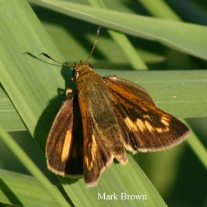
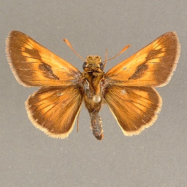
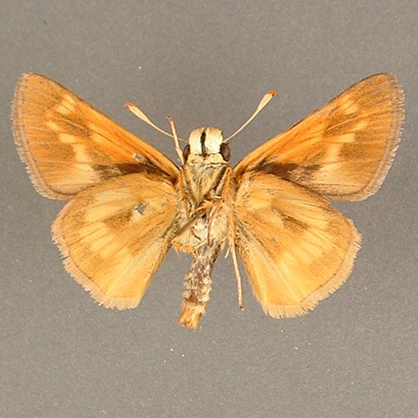
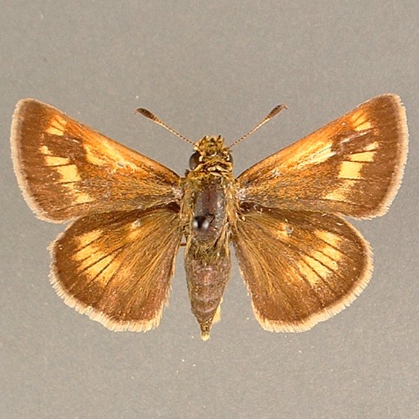
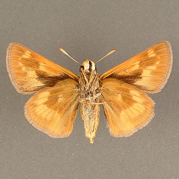
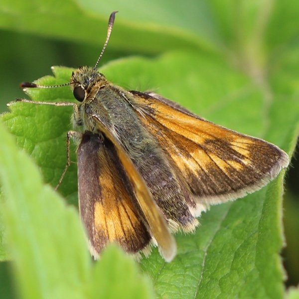
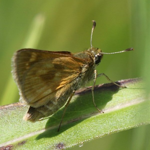
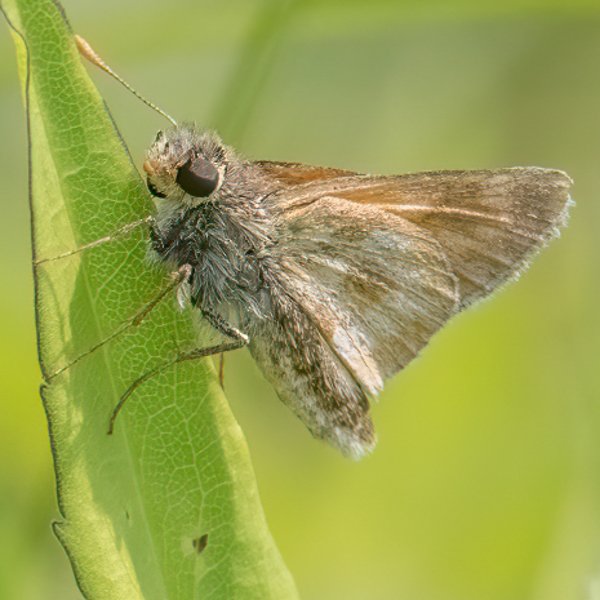
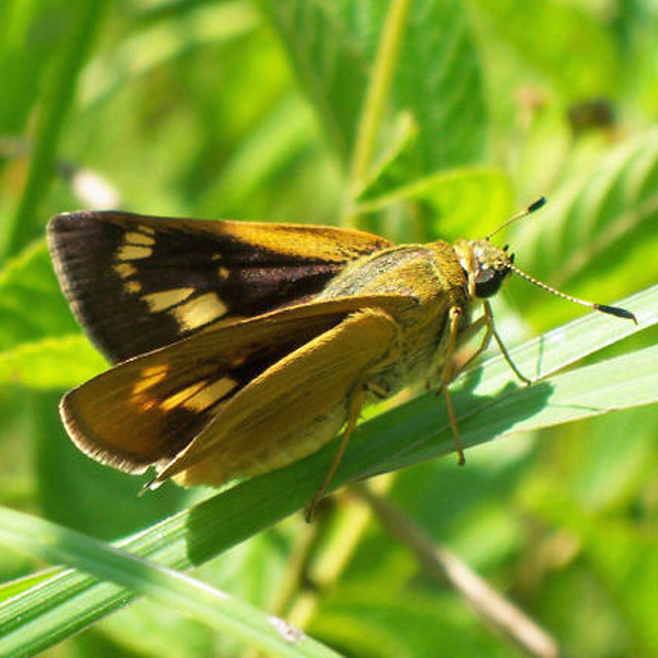
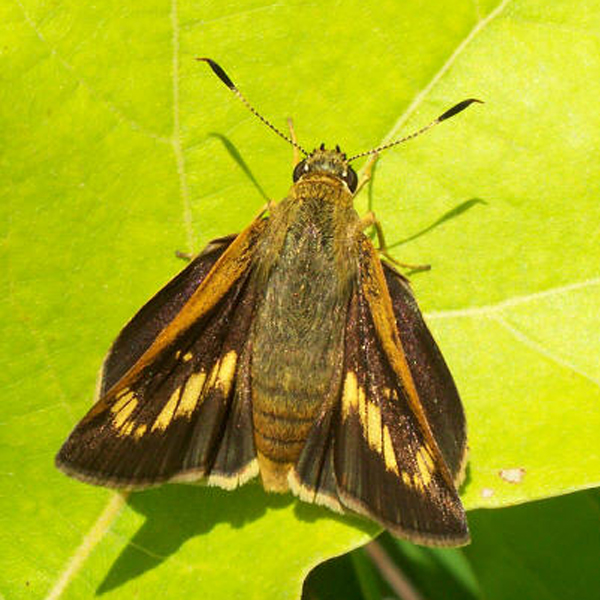
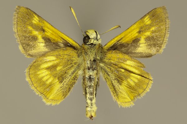
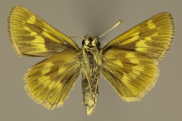
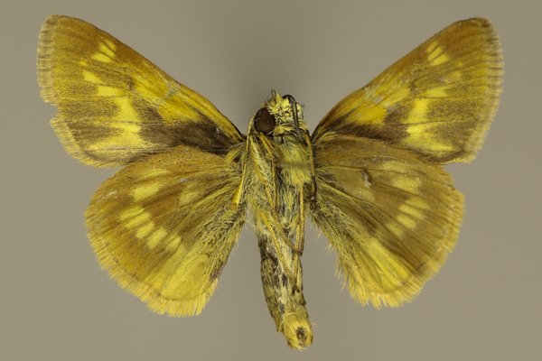
Wing span: 2.7 cm (males), 3.0 cm (females).
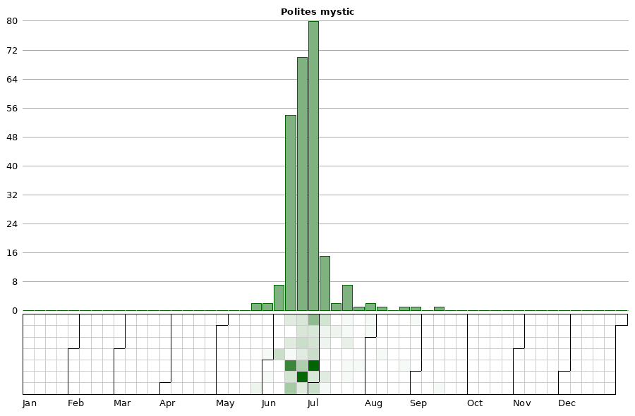
Flight time: A single flight occurs from late May through late July.
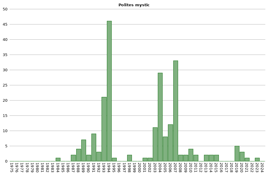
Status: Infrequent breeding resident.
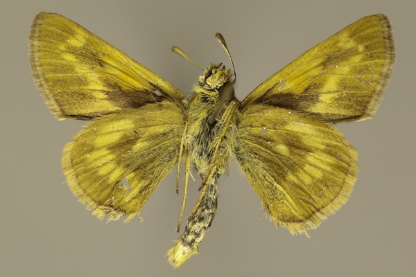
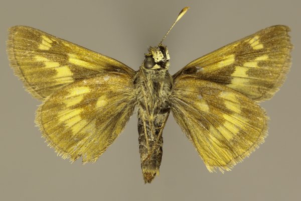
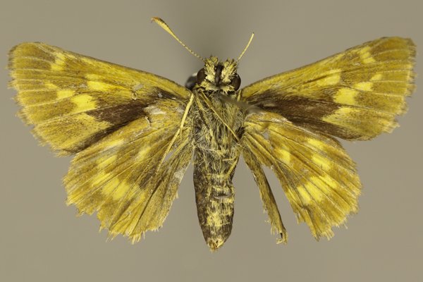
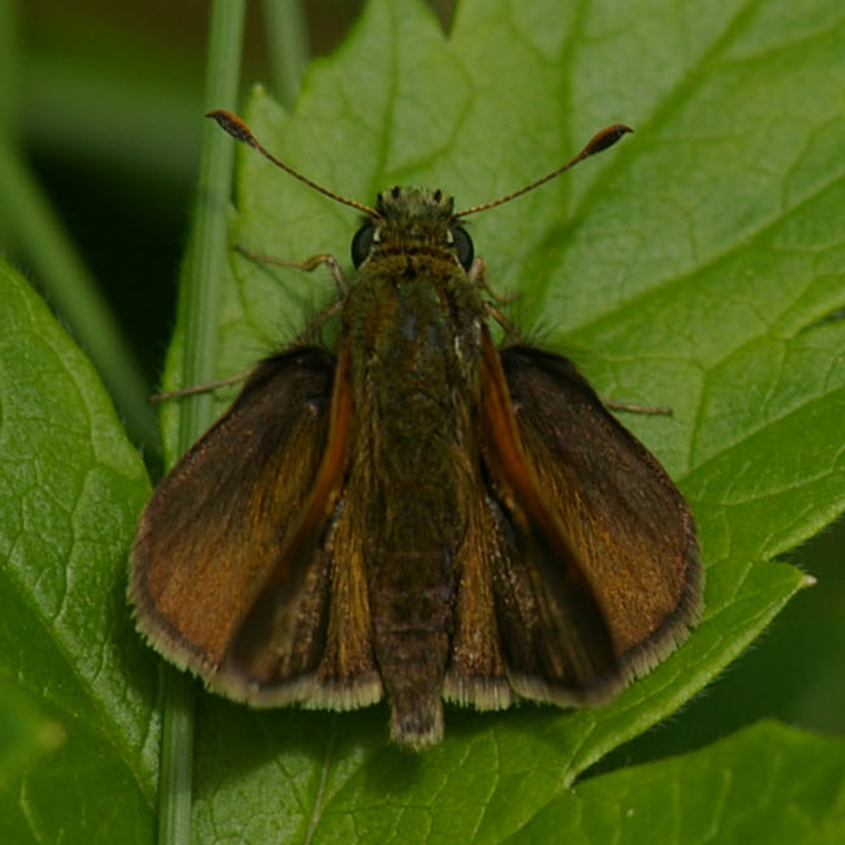
Distinguishing features: As its common name implies, the stigma on males extends over 2/3 of the forewing. The hindwing below is brown with a series of equal-sized tan spots that parallel the wing margin. The female has a broad, dark band winding through the center of the upper forewing.
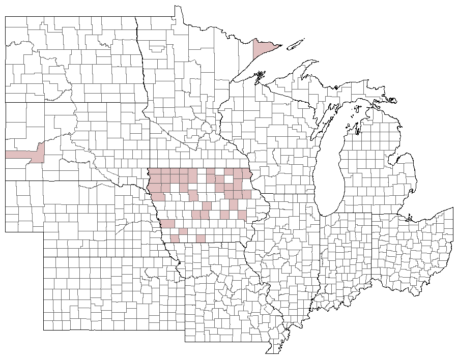
Distribution and habitat: This species is confined to isolated populations in the northern half of the state. In the northwest it is most commonly observed on dry prairie, where it may be found flying with Powesheik and Crossline Skippers. In northeastern Iowa it is limited to fens and occasionally wet prairies. A few, scattered populations have also been located in southwestern Iowa.
Natural History: Larval host plants are unrecorded from any Iowa habitat. Specimens collected from dry prairies in the northwest appear somewhat lighter in color as compared to the wetland forms in the northeast. It is possible that the dry prairie populations represent the subspecies P. m. dacotah, which is known from northern Plains prairies. The northeastern Iowa populations appear identical to those from northern Wisconsin wetlands that are typical P. m. mystic.
**

| Record # | Date | Locale | State | Lat/Lon | Collected By | Count |
|---|---|---|---|---|---|---|
 347274 347274
|
2023-06-21 | Clear Creek Fen | Iowa | 43.452836818333 -91.424037316667 | Tom Schilke | 1 |
 300676 300676
|
2021-07-03 | Clear Creek Fen | Iowa | 43.452358 -91.424706 | Jay Gilliam | 1 |
| 357947 | 2020-07-03 | Neste Valley County Park | Iowa | 43.262 -91.84766667 | Kayla Gibson | 1 |
| 357948 | 2020-07-03 | Neste Valley County Park | Iowa | 43.262 -91.84766667 | Kayla Gibson | 1 |
| 273264 | 2020-07-02 | Crossman Prairie State Preserve | Iowa | 43.408885 -92.474737 | Frank Olsen | 1 |
| 261168 | 2019-08-09 | Big Creek State Park | Iowa | 41.802522 -93.733288 | IBSN | 1 |
| 261167 | 2019-07-30 | Big Creek State Park | Iowa | 41.802522 -93.733288 | IBSN | 1 |
| 248773 | 2019-07-07 | Clear Creek Fen | Iowa | 43.452349 -91.42452 | Chris Edwards | 2 |
| 248792 | 2019-07-07 | Hayden Prairie State Wildlife Management Area | Iowa | 43.434694 -92.385003 | Chris Edwards | 1 |
| 354177 | 2015-06-18 | Chipera Prairie Park | Iowa | 43.1325 -92.0075 | Kirk J. Larsen | 1 |
| 355748 | 2015-06-16 | Hayden Prairie State Wildlife Management Area | Iowa | 43.441667 -92.383333 | Kirk J. Larsen | 1 |
| 7274 | 2014-06-21 | Willow Creek Wildlife Management Area | Iowa | 43.2743 -93.352785 | Aaron Brees | 1 |
| 67744 | 2014-06-21 | Willow Creek Wildlife Management Area | Iowa | 43.2743 -93.352785 | Aaron Brees | 1 |
| 61091 | 2013-06-30 | Hoffman Prairie | Iowa | 43.13306 -93.45667 | Frank Olsen | 2 |
| 5057 | 2011-06-18 | Cedar Hills Sand Prairie Preserve | Iowa | 42.593366 -92.551113 | BAMONA | 1 |
| 9686 | 2011-06-18 | Cedar Hills Sand Prairie Preserve | Iowa | 42.5933333 -92.5511111 | Tom Jantscher | 1 |
| 61095 | 2010-06-19 | Kalsow Prairie State Preserve | Iowa | 42.5734 -94.5677 | Frank Olsen | 4 |
| 7273 | 2009-06-27 | Hoffman Prairie | Iowa | 43.13306 -93.45667 | Aaron Brees | 2 |
 208375 208375
|
2008-07-09 | Slip Bluff County Park | Iowa | 40.65255 -93.84534 | Aaron Brees | 1 |
 208376 208376
|
2008-07-09 | Slip Bluff County Park | Iowa | 40.65255 -93.84534 | Aaron Brees | 1 |
| 141342 | 2007-08-27 | Reiman Gardens Area, Ames | Iowa | 42.01102 -93.638089 | Nathan Brockman | 1 |
| 141276 | 2007-07-31 | Reiman Gardens Area, Ames | Iowa | 42.01102 -93.638089 | Nathan Brockman | 1 |
| 61109 | 2007-07-20 | Rowley Fen | Iowa | 42.37694 -91.85194 | Frank Olsen | 1 |
| 61086 | 2007-06-28 | Hayden Prairie State Wildlife Management Area | Iowa | 43.44055 -92.38058 | Frank Olsen | 2 |
| 61072 | 2007-06-25 | Fairview Prairie Wildlife Area | Iowa | 43.44446 -95.417829 | Frank Olsen | 6 |
| 61078 | 2007-06-25 | Garlock Slough | Iowa | 43.349957 -95.176997 | Frank Olsen | 1 |
| 61089 | 2007-06-25 | Highway 60 MN-IA | Iowa | 43.4968 -95.6956 | Frank Olsen | 2 |
| 61120 | 2007-06-25 | Wolter's Prairie Preserve | Iowa | 42.773263 -92.71744 | Frank Olsen | 2 |
| 61071 | 2007-06-24 | Dugout Creek Wildlife Area | Iowa | 43.4048 -95.3198 | Frank Olsen | 1 |
| 61100 | 2007-06-24 | Lakeville Prairie | Iowa | 43.42 -95.2682 | Frank Olsen | 1 |
| 61121 | 2007-06-24 | Wuedker Prairie | Iowa | 43.4142 -95.2699 | Frank Olsen | 1 |
| 247986 | 2007-06-24 | Dugout Creek Wildlife Area | Iowa | 43.4048 -95.3198 | Frank Olsen | 1 |
| 61061 | 2007-06-23 | Cayler Prairie State Preserve | Iowa | 43.3972 -95.2459 | Frank Olsen | 3 |
| 61062 | 2007-06-23 | Cayler Prairie State Preserve | Iowa | 43.3972 -95.2459 | Frank Olsen | 1 |
| 61119 | 2007-06-23 | Watertower Prairie | Iowa | 43.3781 -95.186 | Frank Olsen | 1 |
| 61102 | 2007-06-22 | Christopherson Slough | Iowa | 43.475 -94.9355 | Frank Olsen | 1 |
| 61113 | 2007-06-22 | Superior RR Prairie East | Iowa | 43.4298 -94.9277 | Frank Olsen | 2 |
| 248185 | 2007-06-22 | Little Swan Lake | Iowa | 43.463953 -94.952366 | Frank Olsen | 2 |
| 61064 | 2007-06-21 | Cayler Prairie State Preserve | Iowa | 43.3972 -95.2459 | Frank Olsen | 1 |
| 61092 | 2007-06-19 | Hoffman Prairie | Iowa | 43.13306 -93.45667 | Frank Olsen | 1 |
| 61108 | 2007-05-31 | Rowley Fen | Iowa | 42.37694 -91.85194 | Frank Olsen | 1 |
| 61106 | 2006-07-27 | Mink Creek Wildlife Area | Iowa | 43.096 -92.7267 | Dennis Schlicht | 1 |
| 61083 | 2006-06-23 | Hayden Prairie State Wildlife Management Area | Iowa | 43.44055 -92.38058 | Frank Olsen | 1 |
 42934 42934
|
2006-06-17 | Golden Eagle Lodge | Minnesota | 48.05537 -90.39812 | Jim Durbin | 1 |
 42935 42935
|
2006-06-17 | Golden Eagle Lodge | Minnesota | 48.05537 -90.39812 | Jim Durbin | 1 |
 42936 42936
|
2006-06-17 | Golden Eagle Lodge | Minnesota | 48.05537 -90.39812 | Jim Durbin | 1 |
 42937 42937
|
2006-06-17 | Golden Eagle Lodge | Minnesota | 48.05537 -90.39812 | Jim Durbin | 1 |
 42938 42938
|
2006-06-17 | Golden Eagle Lodge | Minnesota | 48.05537 -90.39812 | Jim Durbin | 1 |
 42939 42939
|
2006-06-17 | Golden Eagle Lodge | Minnesota | 48.05537 -90.39812 | Jim Durbin | 1 |
 42940 42940
|
2006-06-17 | Golden Eagle Lodge | Minnesota | 48.05537 -90.39812 | Jim Durbin | 1 |
 185516 185516
|
2006-06-17 | Golden Eagle Lodge | Minnesota | 48.054164 -90.398686 | Jim Durbin | 1 |
 185540 185540
|
2006-06-17 | Golden Eagle Lodge | Minnesota | 48.054164 -90.398686 | Jim Durbin | 1 |
| 61107 | 2006-06-02 | Rowley Fen | Iowa | 42.37694 -91.85194 | Frank Olsen | 1 |
| 61065 | 2005-06-28 | Cayler Prairie State Preserve | Iowa | 43.3972 -95.2459 | Jerry Selby | 3 |
| 61084 | 2005-06-22 | Hayden Prairie State Wildlife Management Area | Iowa | 43.44055 -92.38058 | Frank Olsen | 1 |
| 61085 | 2005-06-22 | Hayden Prairie State Wildlife Management Area | Iowa | 43.44055 -92.38058 | Frank Olsen | 1 |
| 61082 | 2005-06-16 | Hayden Prairie State Wildlife Management Area | Iowa | 43.44055 -92.38058 | Frank Olsen | 1 |
| 248024 | 2005-06-16 | Hayden Prairie State Wildlife Management Area | Iowa | 43.44055 -92.38058 | Frank Olsen | 2 |
| 61050 | 2004-07-07 | Anderson Prairie State Preserve, Emmet County | Iowa | 43.441 -94.8724 | Dennis Schlicht | 1 |
| 61063 | 2004-06-29 | Cayler Prairie State Preserve | Iowa | 43.3972 -95.2459 | Frank Olsen | 1 |
| 61076 | 2004-06-29 | Freda Haffner Kettlehole State Preserve | Iowa | 43.349034 -95.222697 | Frank Olsen | 1 |
| 61051 | 2004-06-28 | Anderson Prairie State Preserve, Emmet County | Iowa | 43.441 -94.8724 | Frank Olsen | 17 |
| 61052 | 2004-06-28 | Anderson Prairie State Preserve, Emmet County | Iowa | 43.441 -94.8724 | Jerry Selby | 5 |
| 61079 | 2004-06-12 | Gitchie Manitou State Preserve | Iowa | 43.4997 -96.5983 | Frank Olsen | 1 |
| 61080 | 2004-06-12 | Gitchie Manitou State Preserve | Iowa | 43.4997 -96.5983 | Frank Olsen | 3 |
| 61068 | 2003-07-17 | Cedar Hills Sand Prairie Preserve | Iowa | 42.59305 -92.55315 | Frank Olsen | 1 |
| 61103 | 2003-07-02 | Milford Fen | Iowa | 43.339325 -95.161407 | Frank Olsen | 1 |
| 61104 | 2003-07-02 | Milford Fen | Iowa | 43.338442 -95.161131 | Frank Olsen | 1 |
| 61105 | 2003-07-02 | Milford Fen | Iowa | 43.33806 -95.159354 | Frank Olsen | 1 |
| 61073 | 2003-07-01 | Fen Valley Area | Iowa | 43.015854 -95.018676 | Frank Olsen | 1 |
| 61074 | 2003-07-01 | Fen Valley Area | Iowa | 43.015854 -95.018676 | Frank Olsen | 1 |
| 61093 | 2003-07-01 | Kalsow Prairie State Preserve | Iowa | 42.5734 -94.5677 | Frank Olsen | 3 |
| 61094 | 2003-07-01 | Kalsow Prairie State Preserve | Iowa | 42.5734 -94.5677 | Frank Olsen | 1 |
| 61069 | 2003-06-17 | Cedar Hills Sand Prairie Preserve | Iowa | 42.59305 -92.55315 | Frank Olsen | 1 |
| 118192 | 2002-06-23 | Crumbacher Wildlife Area | Iowa | 42.438138 -91.985819 | Chris Edwards | 1 |
| 118191 | 2001-07-18 | MacBride Nature Recreation Area | Iowa | 41.786242 -91.566399 | Chris Edwards | 1 |
| 61070 | 1998-06-22 | Chipera Prairie Park | Iowa | 43.13052 -92.00603 | 1 | |
| 354176 | 1998-06-22 | Chipera Prairie Park | Iowa | 43.1325 -92.0075 | Jennifer Bovee | 1 |
| 355601 | 1995-06-30 | Harney Peak Ranch | South Dakota | 44.04173 -103.13433 | Kirk J. Larsen | 1 |
| 107660 | 1994-06-29 | Dickinson County, Iowa | Iowa | Location Protected | Mike Saunders | 1 |
| 247041 | 1994-06-29 | Little Sioux Park | Iowa | 42.449675 -95.799742 | Mike Saunders | 10 |
| 61067 | 1994-06-28 | Cedar Hills Sand Prairie Preserve | Iowa | 42.59305 -92.55315 | Ed Freese | 2 |
| 61112 | 1994-06-23 | Spring Run State Game Management Area | Iowa | 43.427403 -95.062584 | Mike Saunders | 20 |
| 107659 | 1994-06-23 | Dickinson County, Iowa | Iowa | Location Protected | Mike Saunders | 1 |
| 247040 | 1994-06-23 | Four Mile Lake Wildlife Management Area | Iowa | 43.395994 -94.908561 | Mike Saunders | 6 |
| 61087 | 1994-06-20 | Hidden Bridge Wildlife Area | Iowa | 43.415681 -96.563796 | Mike Saunders | 2 |
| 61116 | 1994-06-18 | Telford Prairie | Iowa | 43.065 -94.7914 | Ron Harms | 1 |
| 61118 | 1994-06-18 | Telford Prairie | Iowa | 43.065 -94.7914 | Ron Harms | 1 |
| 107652 | 1994-06-11 | Mount Talbot State Preserve | Iowa | 42.564259 -96.469482 | Tim Orwig | 1 |
| 107653 | 1994-06-11 | Mount Talbot State Preserve | Iowa | 42.564345 -96.469638 | Tim Orwig | 1 |
| 61090 | 1993-07-21 | Highway 60 MN-IA | Iowa | 43.4968 -95.6956 | Mike Saunders | 1 |
| 61101 | 1993-07-18 | Lekwa Marsh Wildlife Management Area | Iowa | 43.109131 -93.406321 | Mike Saunders | 1 |
| 107664 | 1993-07-18 | Diamond Lake Wildlife Management Area | Iowa | 43.485709 -95.189543 | Mike Saunders | 1 |
| 61060 | 1993-07-16 | Bokelmann Prairie | Iowa | 43.15267 -93.47017 | Mike Saunders | 1 |
| 61056 | 1993-07-02 | Blood Run Preserve | Iowa | 43.468461 -96.568663 | Mike Saunders | 1 |
| 61077 | 1993-07-02 | Freda Haffner Kettlehole State Preserve | Iowa | 43.349034 -95.222697 | Mike Saunders | 2 |
| 61055 | 1993-06-26 | Blood Run Preserve | Iowa | 43.468461 -96.568663 | Mike Saunders | 1 |
| 61057 | 1993-06-26 | Blood Run Preserve | Iowa | 43.468461 -96.568663 | Ron Harms | 2 |
| 61058 | 1993-06-26 | Blood Run Preserve | Iowa | 43.468461 -96.568663 | Ron Harms | 1 |
| 61088 | 1993-06-26 | Hidden Bridge Wildlife Area | Iowa | 43.415681 -96.563796 | Mike Saunders | 1 |
| 61114 | 1993-06-25 | Telford Prairie | Iowa | 43.065 -94.7914 | Ron Harms | 3 |
| 61115 | 1993-06-25 | Telford Prairie | Iowa | 43.065 -94.7914 | Ron Harms | 1 |
| 61066 | 1993-06-22 | Cedar Hills Sand Prairie Preserve | Iowa | 42.59305 -92.55315 | Ed Freese | 2 |
| 61096 | 1993-06-20 | Kalsow Prairie State Preserve | Iowa | 42.5734 -94.5677 | Ron Harms | 2 |
| 61097 | 1993-06-20 | Kalsow Prairie State Preserve | Iowa | 42.5734 -94.5677 | Ron Harms | 1 |
| 107654 | 1992-09-15 | Mount Talbot State Preserve | Iowa | 42.564376 -96.469412 | Tim Orwig | 1 |
| 61075 | 1992-06-26 | Five Ridge Prairie State Preserve | Iowa | 42.67867 -96.53473 | Tim Orwig | 1 |
 144204 144204
|
1992-06-13 | Rowley Fen | Iowa | 42.37694 -91.85194 | Frank Olsen | 1 |
| 61059 | 1991-08-24 | Blood Run Preserve | Iowa | 43.468461 -96.568663 | Tim Orwig | 1 |
| 61117 | 1991-07-07 | Telford Prairie | Iowa | 43.065 -94.7914 | Ron Harms | 1 |
| 271916 | 1991-06-07 | Telford Prairie | Iowa | 43.065 -94.7914 | Ron Harms | 7 |
| 107656 | 1990-06-20 | Pocahontas County | Iowa | 42.74456 -94.683864 | Ron Harms | 1 |
| 107658 | 1990-06-20 | Pocahontas County | Iowa | 42.74456 -94.683864 | Ron Harms | 1 |
 42945 42945
|
1989-07-01 | Tim Orwig Specimen No data-x | Iowa | 42.64444 -96.35806 | Tim Orwig | 1 |
| 107655 | 1989-06-27 | Pocahontas County | Iowa | 42.74456 -94.683864 | Ron Harms | 1 |
| 107657 | 1989-06-27 | Pocahontas County | Iowa | 42.74456 -94.683864 | Ron Harms | 1 |
| 61053 | 1989-06-17 | Barringer Slough State Game Management Area | Iowa | 43.1464 -94.93163 | Tim Orwig | 2 |
| 61098 | 1989-06-16 | Kalsow Prairie State Preserve | Iowa | 42.5734 -94.5677 | Ron Harms | 1 |
| 61099 | 1989-06-16 | Kalsow Prairie State Preserve | Iowa | 42.5734 -94.5677 | Ron Harms | 1 |
| 107661 | 1988-06-28 | Silver Lake Fen State Preserve | Iowa | 43.436928 -95.365971 | Tim Orwig | 1 |
| 107662 | 1988-06-28 | Silver Lake Fen State Preserve | Iowa | 43.436928 -95.365971 | Tim Orwig | 1 |
| 61110 | 1988-05-26 | Sioux City State Prairie Preserve | Iowa | 42.5241 -96.4362 | Tim Orwig | 1 |
| 61111 | 1988-05-26 | Sioux City State Prairie Preserve | Iowa | 42.5241 -96.4362 | Tim Orwig | 1 |
| 61081 | 1987-06-11 | Gitchie Manitou State Preserve | Iowa | 43.4997 -96.5983 | Tim Orwig | 1 |
| 107663 | 1987-06-11 | Larchwood | Iowa | 43.452312 -96.431715 | Tim Orwig | 1 |
| 61054 | 1984-06-26 | Blazing Star Prairie, Buchanan | Iowa | 42.35473 -91.806338 | Dennis Schlicht | 1 |
| 5054 | 1950-06-15 | Adams County | Iowa | 41.065208 -94.686378 | USGS - NPWRC | 1 |
| 5055 | 1950-06-15 | Benton County | Iowa | 42.138725 -92.066521 | USGS - NPWRC | 1 |
| 5056 | 1950-06-15 | Black Hawk County | Iowa | 42.447803 -92.381363 | USGS - NPWRC | 1 |
| 5058 | 1950-06-15 | Bremer County | Iowa | 42.761082 -92.381363 | USGS - NPWRC | 1 |
| 5059 | 1950-06-15 | Buchanan County | Iowa | 42.4566 -91.909927 | USGS - NPWRC | 1 |
| 5060 | 1950-06-15 | Cerro Gordo County | Iowa | 43.048603 -93.33889 | USGS - NPWRC | 1 |
| 5061 | 1950-06-15 | Cherokee County | Iowa | 42.802776 -95.645798 | USGS - NPWRC | 1 |
| 5062 | 1950-06-15 | Clay County | Iowa | 43.136803 -95.143204 | USGS - NPWRC | 1 |
| 5063 | 1950-06-15 | Dallas County | Iowa | 41.612003 -93.987846 | USGS - NPWRC | 1 |
| 5064 | 1950-06-15 | Delaware County | Iowa | 42.463402 -91.443466 | USGS - NPWRC | 1 |
| 5065 | 1950-06-15 | Dickinson County | Iowa | 43.404938 -95.184921 | USGS - NPWRC | 1 |
| 5066 | 1950-06-15 | Emmet County | Iowa | 43.34943 -94.686378 | USGS - NPWRC | 1 |
| 5067 | 1950-06-15 | Fayette County | Iowa | 42.925819 -91.909927 | USGS - NPWRC | 1 |
| 5068 | 1950-06-15 | Floyd County | Iowa | 43.061596 -92.857712 | USGS - NPWRC | 1 |
| 5069 | 1950-06-15 | Howard County | Iowa | 43.38195 -92.381363 | USGS - NPWRC | 1 |
| 5070 | 1950-06-15 | Johnson County | Iowa | 41.669899 -91.598396 | USGS - NPWRC | 1 |
| 5071 | 1950-06-15 | Kossuth County | Iowa | 43.251339 -94.233337 | USGS - NPWRC | 1 |
| 5072 | 1950-06-15 | Lyon County | Iowa | 43.3936 -96.2479 | USGS - NPWRC | 1 |
| 5073 | 1950-06-15 | O'Brien County | Iowa | 43.113125 -95.645798 | USGS - NPWRC | 1 |
| 5074 | 1950-06-15 | Page County | Iowa | 40.763512 -95.143204 | USGS - NPWRC | 1 |
| 5075 | 1950-06-15 | Palo Alto County | Iowa | 43.158089 -94.645035 | USGS - NPWRC | 1 |
| 5076 | 1950-06-15 | Pocahontas County | Iowa | 42.691803 -94.645035 | USGS - NPWRC | 1 |
| 5077 | 1950-06-15 | Pottawattamie County | Iowa | 41.391151 -95.477783 | USGS - NPWRC | 1 |
| 5078 | 1950-06-15 | Poweshiek County | Iowa | 41.653011 -92.539604 | USGS - NPWRC | 1 |
| 5079 | 1950-06-15 | Sioux County | Iowa | 43.086994 -96.152695 | USGS - NPWRC | 1 |
| 5080 | 1950-06-15 | Webster County | Iowa | 42.397495 -94.151375 | USGS - NPWRC | 1 |
| 5081 | 1950-06-15 | Woodbury County | Iowa | 42.316616 -95.983261 | USGS - NPWRC | 1 |