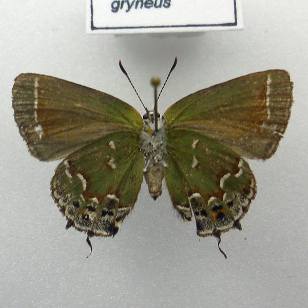
Wing span: 2.2-3.2 cm.
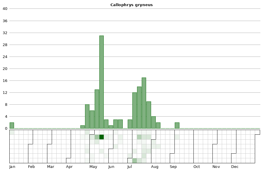
Flight time: Two broods; the first flying from late-April through May, the second from late-June through early August.
Status: Breeding resident.
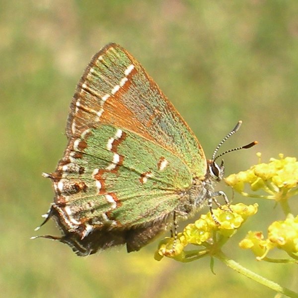
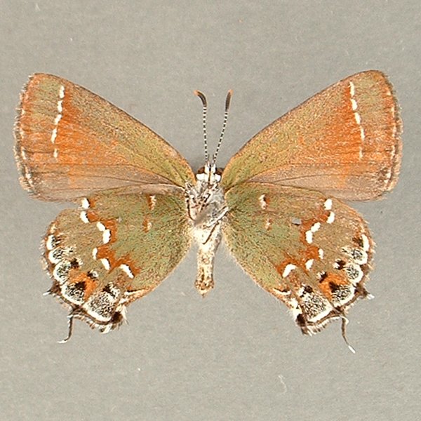
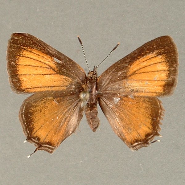
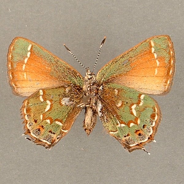
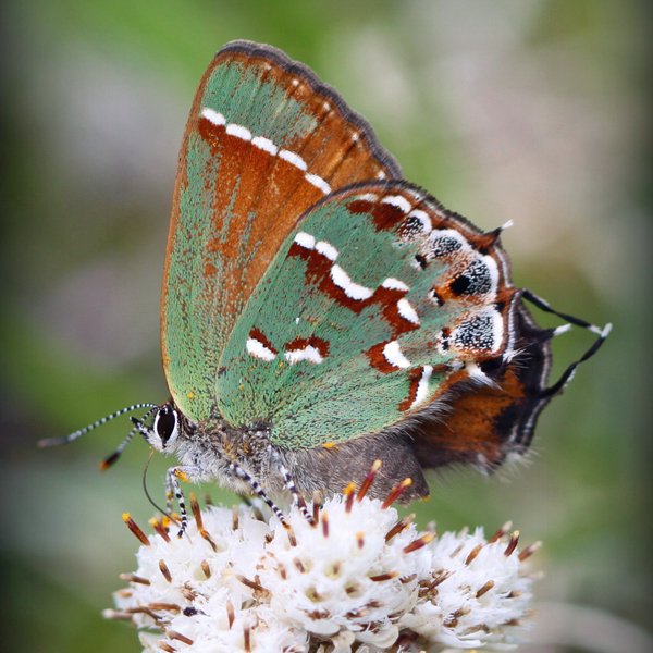
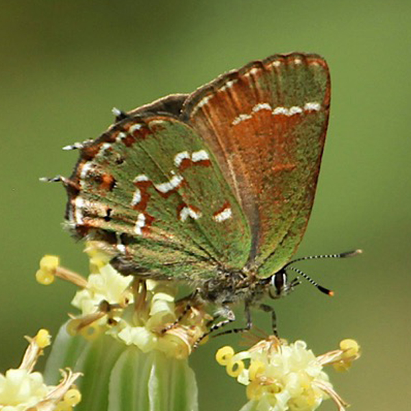
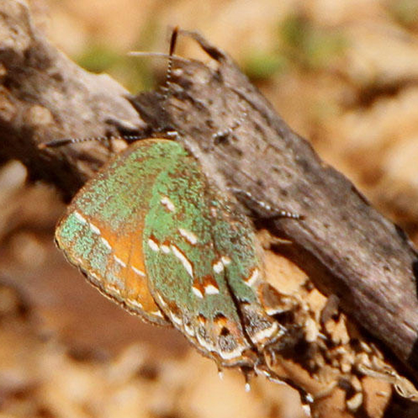
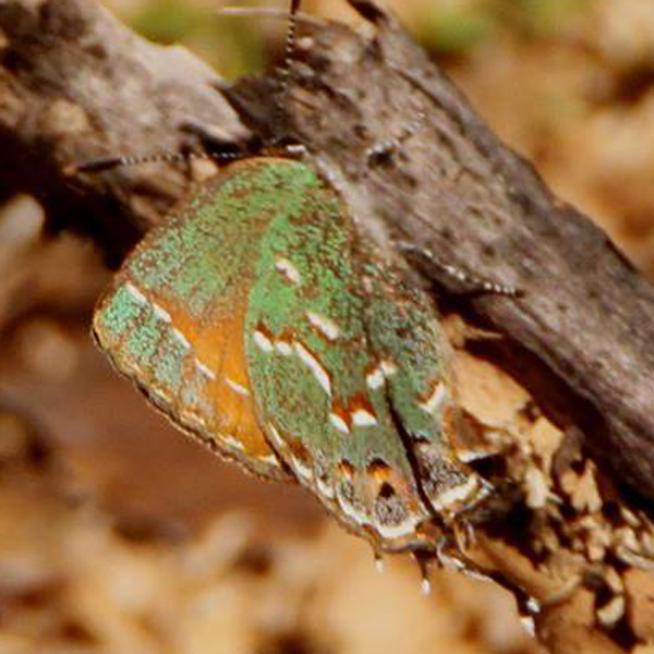
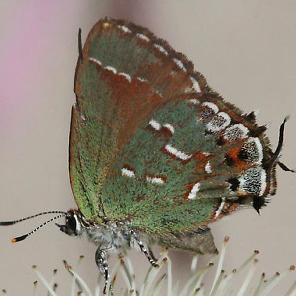
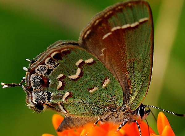
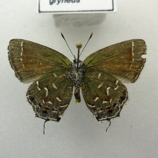
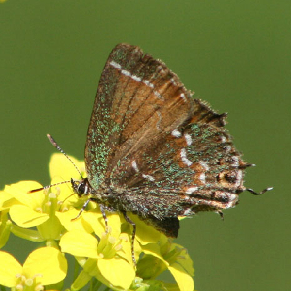
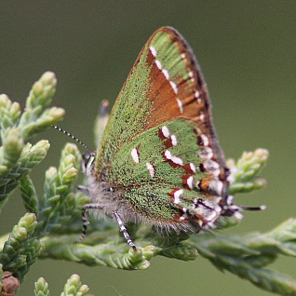
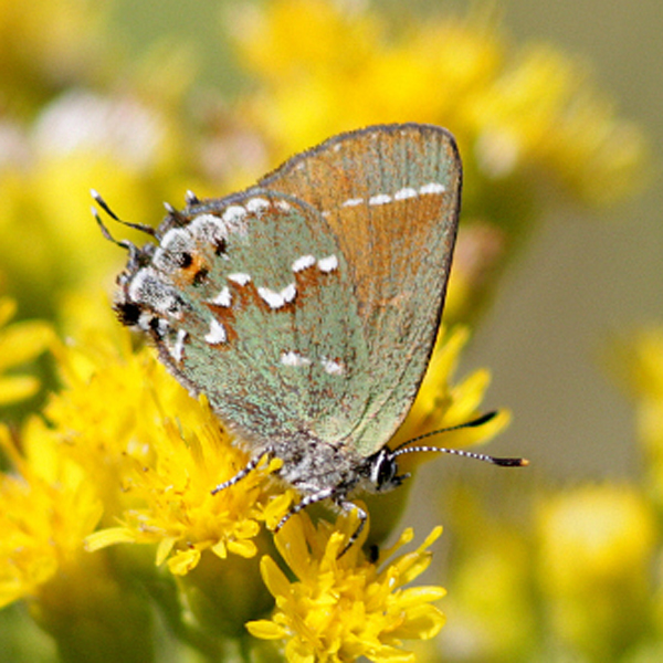
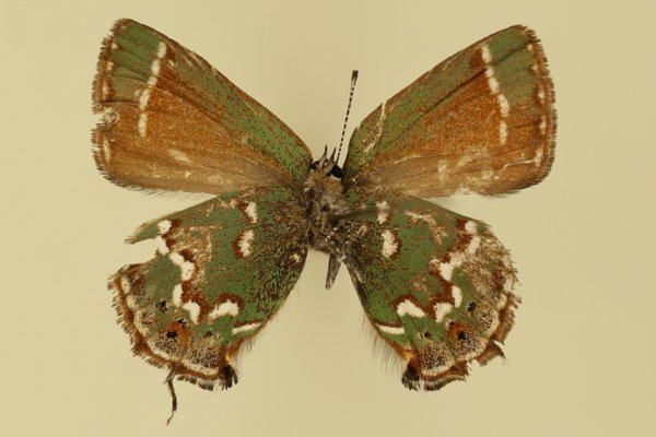
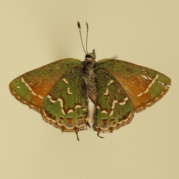
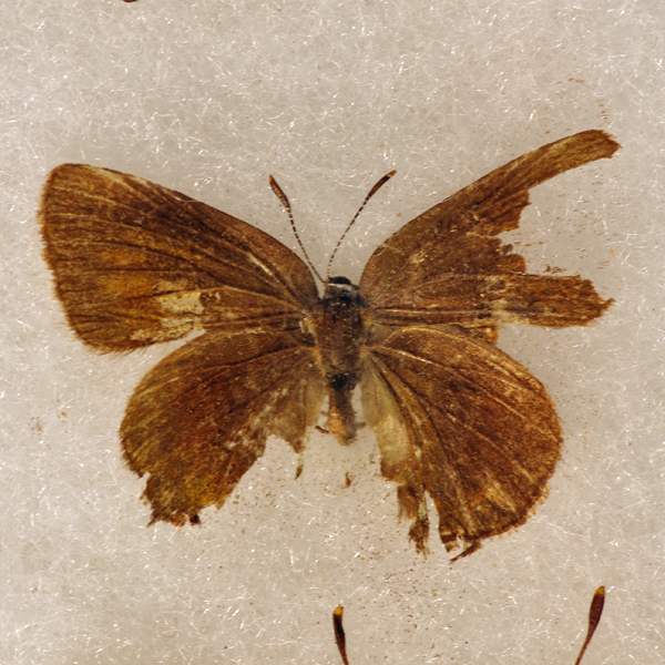
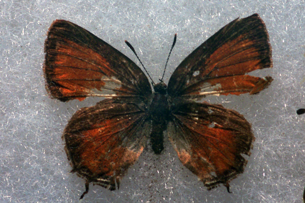
Distinguishing features: The wing underside is a striking green with a jagged white postmedial line bordered medially in brown. Wing appearance above changes between the two broods. In the spring both fore and hindwings have orange-brown centers with brown margins. In the summer form, the upper wing surface is unmarked and dark brown.
Distribution and habitat: Uncommon, with populations concentrated in the eastern and western thirds of the state. It occurs most frequently on limestone and sand prairies in the east and the Loess Hill and xeric gravel prairie in the west.
Natural History: Larvae consume red cedar (Juniperus virginiana) living on the margins or matrix of native xeric prairie. Adults rest in cedar branches with wings closed, allowing the green cast of the hindwing underside to afford a good degree of camouflage. Sweeping (or beating) cedar branches is often an effective sampling method when adults are not active. Active individuals may commonly be seen in spiral encounter flights above cedar trees. Although cedar is common throughout Iowa in a variety of disturbed habitats (like old fields), populations of the olive hairstreak have yet to be found in such situations. It has also not been found in the central third of the state, in spite of repeated location attempts.


| Record # | Date | Locale | State | Lat/Lon | Collected By | Count |
|---|---|---|---|---|---|---|
 349517 349517
|
2023-07-08 | Hitchcock Nature Center | Iowa | 41.411384 -95.85674 | Loren & Babs Padelford | 1 |
 224983 224983
|
2018-06-07 | Clear Creek Fen | Iowa | 43.452815 -91.424687 | Tom Schilke | 1 |
 224984 224984
|
2018-06-07 | Clear Creek Fen | Iowa | 43.452815 -91.424687 | Tom Schilke | 1 |
| 194375 | 2017-07-17 | Woodburn | Iowa | 41.01194 -93.59911 | Jacob Newton | 1 |
 194380 194380
|
2017-04-24 | Geode State Park | Iowa | 40.823969 -91.378233 | Mark Brown | 1 |
 186915 186915
|
2017-04-23 | Geode State Park | Iowa | 40.81944 -91.39194 | Mark Brown | 1 |
 201903 201903
|
2017-04-23 | Geode State Park | Iowa | 40.81944 -91.39194 | Mark Brown | 1 |
| 202737 | 2017-04-17 | Shimek State Forest, Farmington Unit | Iowa | 40.653998 -91.72554 | Chris Edwards | 1 |
| 180515 | 2016-07-15 | Medora Prairie | Iowa | 41.209512 -93.627408 | Frank Olsen | 1 |
| 180484 | 2016-07-09 | Hamilton Prairie, Jackson County | Iowa | 42.07133 -90.559 | Frank Olsen | 1 |
 200626 200626
|
2016-07-08 | Pella | Iowa | 41.412205 -92.905646 | SR Johnson | 1 |
| 171591 | 2016-07-05 | Hitchcock Nature Center | Iowa | 41.41733 -95.85388 | Doug Veal | 1 |
| 130923 | 2015-07-22 | Armund Bartz Prairie | Iowa | 43.429728 -91.310705 | Frank Olsen | 1 |
| 131349 | 2015-07-22 | Mile Long Prairie | Iowa | 43.40655 -91.550008 | Frank Olsen | 1 |
| 130943 | 2015-07-21 | Black Hawk Point Wildlife Management Area | Iowa | 43.4602778 -91.2980555 | Frank Olsen | 2 |
| 128236 | 2015-07-18 | Hitchcock Nature Center | Iowa | 41.41733 -95.85388 | Ed Freese | 1 |
| 358592 | 2014-07-23 | Mile Long Prairie | Iowa | 43.4065 -91.563833 | Kirk J. Larsen | 1 |
 143520 143520
|
2014-07-19 | Marion County | Iowa | 41.325547 -93.069235 | Ron Huelse | 1 |
| 51339 | 2013-07-10 | Hitchcock Nature Center | Iowa | 41.41733 -95.85388 | Ed Freese | 1 |
| 359305 | 2013-06-13 | Zoll's Mountain Hill Prairie | Iowa | 43.439333 -91.3315 | Kirk J. Larsen | 1 |
| 2114 | 2012-07-07 | Yellow River State Forest | Iowa | 43.1619688 -91.218672 | BAMONA | 1 |
 7822 7822
|
2012-07-07 | Yellow River State Forest | Iowa | 43.1619444 -91.2186111 | Tom Jantscher | 1 |
 7823 7823
|
2012-07-07 | Yellow River State Forest | Iowa | 43.1738889 -91.2211111 | Tom Jantscher | 1 |
| 7824 | 2012-07-07 | Yellow River State Forest | Iowa | 43.1727778 -91.2216667 | Tom Jantscher | 1 |
| 112585 | 2012-07-07 | Yellow River State Forest | Iowa | 43.170603 -91.240395 | Chris Edwards | 5 |
 144142 144142
|
2012-05-05 | Ciha Fen Wildlife Preserve | Iowa | 41.82917 -91.38278 | Mark Brown | 1 |
| 51332 | 2012-04-26 | Ciha Fen Wildlife Preserve | Iowa | 41.82917 -91.38278 | Scarths | 1 |
| 6553 | 2011-07-24 | Sylvan Runkel State Preserve | Iowa | 42.105 -95.98233 | Aaron Brees | 1 |
| 6554 | 2011-07-24 | Folsom Point Preserve | Iowa | 41.153044 -95.796881 | Aaron Brees | 3 |
| 112584 | 2011-07-17 | Yellow River State Forest | Iowa | 43.170603 -91.240395 | Chris Edwards | 1 |
| 6551 | 2011-05-22 | Folsom Point Preserve | Iowa | 41.153044 -95.796881 | Aaron Brees | 2 |
 208665 208665
|
2011-05-08 | Folsom Point Preserve | Iowa | 41.15304 -95.79688 | Aaron Brees | 10 |
 208664 208664
|
2011-05-05 | Folsom Point Preserve | Iowa | 41.15304 -95.79688 | Aaron Brees | 1 |
 208663 208663
|
2010-09-04 | Folsom Point Preserve | Iowa | 41.15304 -95.79688 | Aaron Brees | 1 |
 138213 138213
|
2010-09-04 | Folsom Point Preserve | Iowa | 41.163523 -95.797316 | Aaron Brees | 1 |
| 6549 | 2010-05-29 | Loess Hills State Forest, Little Sioux Unit | Iowa | 41.80231 -95.98757 | Aaron Brees | 1 |
| 135116 | 2008-07-26 | Folsom Point Preserve | Iowa | 41.153044 -95.796881 | Tom Jantscher | 3 |
| 106760 | 2008-05-17 | Adel - Prairie Seed Production Plots | Iowa | 41.658682 -94.030508 | Ed Freese | 1 |
| 51343 | 2007-07-11 | Manikowski Prairie State Preserve | Iowa | 41.972843 -90.375383 | Frank Olsen | 1 |
| 51344 | 2007-07-01 | Manikowski Prairie State Preserve | Iowa | 41.972843 -90.375383 | Frank Olsen | 1 |
| 355785 | 2007-05-26 | Heritage Valley | Iowa | 43.371 -91.578833 | Kirk J. Larsen | 1 |
| 112581 | 2006-07-15 | Hawkeye Willdlife Management Area | Iowa | 41.775104 -91.705532 | Chris Edwards | 4 |
| 106761 | 2006-04-23 | Dallas County | Iowa | 41.682923 -94.021682 | Harlan Ratcliff | 1 |
| 112583 | 2003-04-26 | Beam's Woods | Iowa | 42.142425 -91.343915 | Chris Edwards | 1 |
| 106764 | 2002-07-26 | Anderson Prairie, Decorah | Iowa | 43.315099 -91.800701 | Kirk Larsen | 1 |
| 112580 | 2002-07-20 | Rochester Cemetery | Iowa | 41.664973 -91.13914 | Chris Edwards | 1 |
| 112582 | 2001-07-21 | MacBride Nature Recreation Area | Iowa | 41.786242 -91.566399 | Chris Edwards | 1 |
 18212 18212
|
2001-04-29 | Westphal Timber, Jones | Iowa | 42.1349 -90.95348 | Jim Durbin | 1 |
 240089 240089
|
2000-04-30 | Westphal Timber, Jones | Iowa | 42.1359861 -90.9607556 | Jim Durbin | 1 |
| 51330 | 1999-07-10 | Five Ridge Prairie State Preserve | Iowa | 42.6496 -96.5032 | Tim Orwig | 1 |
| 51350 | 1998-07-20 | Winneshiek County | Iowa | 43.23626 -91.90993 | 1 | |
| 354568 | 1998-07-20 | Decorah-x | Iowa | 43.30333 -91.78556 | Jennifer Bovee | 1 |
| 51349 | 1998-06-12 | Winneshiek County | Iowa | 43.23626 -91.90993 | 1 | |
| 354567 | 1998-06-12 | Decorah-x | Iowa | 43.30333 -91.78556 | Jennifer Bovee | 1 |
| 112586 | 1998-05-14 | Yellow River State Forest | Iowa | 43.170603 -91.240395 | Chris Edwards | 1 |
| 51331 | 1994-07-10 | Cedar Hills Sand Prairie Preserve | Iowa | 42.59305 -92.55315 | Ed Freese | 2 |
| 51338 | 1992-08-08 | Hitaga Sand Ridge Prairie Preserve | Iowa | 42.25233 -91.63633 | Frank Olsen | 1 |
| 51347 | 1992-08-08 | Millard Preserve | Iowa | 42.227954 -91.5335 | Frank Olsen | 1 |
| 51336 | 1992-08-01 | Hitaga Sand Ridge Prairie Preserve | Iowa | 42.25233 -91.63633 | Frank Olsen | 1 |
 144434 144434
|
1992-08-01 | Hitaga Sand Ridge Prairie Preserve | Iowa | 42.24944 -91.63056 | Frank Olsen | 1 |
| 51337 | 1992-07-18 | Hitaga Sand Ridge Prairie Preserve | Iowa | 42.25233 -91.63633 | Frank Olsen | 1 |
| 51346 | 1992-05-17 | Millard Preserve | Iowa | 42.227954 -91.5335 | Frank Olsen | 1 |
| 51345 | 1992-05-08 | Millard Preserve | Iowa | 42.227954 -91.5335 | Frank Olsen | 1 |
 144394 144394
|
1992-05-08 | Millard Preserve | Iowa | 42.227871 -91.532398 | Frank Olsen | 1 |
| 51342 | 1991-07-06 | Loess Hills Wildlife Management Area | Iowa | 42.08 -95.9765 | Tim Orwig | 1 |
| 124803 | 1990-08-01 | Bearbower Sand Prairie | Iowa | 42.29944 -91.92722 | Frank Olsen | 1 |
 144195 144195
|
1990-08-01 | Bearbower Sand Prairie | Iowa | 42.29944 -91.92722 | Frank Olsen | 1 |
| 106763 | 1989-07-21 | Pocahontas County | Iowa | 42.74456 -94.683864 | Ron Harms | 1 |
| 106762 | 1989-07-17 | Pocahontas County | Iowa | 42.74456 -94.683864 | Ron Harms | 2 |
| 51334 | 1988-06-03 | Five Ridge Prairie State Preserve | Iowa | 42.67867 -96.53473 | Tim Orwig | 1 |
| 51333 | 1988-05-01 | Five Ridge Prairie State Preserve | Iowa | 42.67867 -96.53473 | Tim Orwig | 1 |
| 51335 | 1987-07-10 | French Creek Wildlife Management Area | Iowa | 43.39075 -91.412 | J. Nehuevaj | 1 |
| 106759 | 1987-07-10 | Big Sand Mound Prairie Preserve, Muscatine County | Iowa | 41.341015 -91.086545 | Dennis Schlicht | 1 |
| 358843 | 1987-07-10 | Sunflower Drive Hill Prairie | Iowa | 43.387 -91.456 | John G. Nehnevaj | 1 |
| 51340 | 1987-06-30 | Pool Slough Wildlife Management Area | Iowa | 43.495821 -91.282811 | J. Nehuevaj | 1 |
| 353922 | 1987-06-30 | Chimney Rock Prairie | Iowa | 43.4675 -91.325 | John G. Nehnevaj | 1 |
| 106758 | 1987-05-09 | Big Sand Mound Prairie Preserve, Muscatine County | Iowa | 41.341015 -91.086545 | Dennis Schlicht | 1 |
| 51341 | 1987-05-01 | Lansing | Iowa | 43.36088 -91.21897 | J. Nehuevaj | 1 |
| 51348 | 1987-05-01 | Clear Creek Fen | Iowa | 43.455306 -91.42388 | J. Nehuevaj | 1 |
| 106757 | 1987-04-27 | Big Sand Mound Prairie Preserve, Muscatine County | Iowa | 41.341015 -91.086545 | Dennis Schlicht | 1 |
| 356710 | 1987-01-01 | Lansing Township | Iowa | 43.382555 -91.282124 | John G. Nehnevaj | 1 |
| 358077 | 1987-01-01 | Potter's Prairie | Iowa | 43.4825 -91.412333 | John G. Nehnevaj | 1 |
| 2113 | 1950-05-15 | Allamakee County | Iowa | 43.243076 -91.443466 | USGS - NPWRC | 1 |
| 2115 | 1950-05-15 | Benton County | Iowa | 42.138725 -92.066521 | USGS - NPWRC | 1 |
| 2116 | 1950-05-15 | Black Hawk County | Iowa | 42.447803 -92.381363 | USGS - NPWRC | 1 |
| 2117 | 1950-05-15 | Buchanan County | Iowa | 42.4566 -91.909927 | USGS - NPWRC | 1 |
| 2118 | 1950-05-15 | Buena Vista County | Iowa | 42.750217 -92.857712 | USGS - NPWRC | 1 |
| 2119 | 1950-05-15 | Clay County | Iowa | 43.136803 -95.143204 | USGS - NPWRC | 1 |
| 2120 | 1950-05-15 | Clayton County | Iowa | 42.77853 -91.289101 | USGS - NPWRC | 1 |
| 2121 | 1950-05-15 | Clinton County | Iowa | 41.878563 -90.563606 | USGS - NPWRC | 1 |
| 2122 | 1950-05-15 | Fayette County | Iowa | 42.925819 -91.909927 | USGS - NPWRC | 1 |
| 2123 | 1950-05-15 | Sidney | Iowa | 40.74004 -95.645798 | USGS - NPWRC | 1 |
| 2124 | 1950-05-15 | Harrison County | Iowa | 41.693386 -95.814285 | USGS - NPWRC | 1 |
| 2125 | 1950-05-15 | Henry County | Iowa | 41.028358 -91.598396 | USGS - NPWRC | 1 |
| 2126 | 1950-05-15 | Jackson County | Iowa | 42.156071 -90.52578 | USGS - NPWRC | 1 |
| 2127 | 1950-05-15 | Johnson County | Iowa | 41.669899 -91.598396 | USGS - NPWRC | 1 |
| 2128 | 1950-05-15 | Jones County | Iowa | 42.151672 -91.1353 | USGS - NPWRC | 1 |
| 2129 | 1950-05-15 | Linn County | Iowa | 42.027289 -91.67275 | USGS - NPWRC | 1 |
| 2130 | 1950-05-15 | Louisa County | Iowa | 41.193298 -91.289101 | USGS - NPWRC | 1 |
| 2131 | 1950-05-15 | Lyon County | Iowa | 43.3936 -96.2479 | USGS - NPWRC | 1 |
| 2132 | 1950-05-15 | Madison County | Iowa | 41.292236 -93.987846 | USGS - NPWRC | 1 |
| 2133 | 1950-05-15 | Mills County | Iowa | 41.06245 -95.645798 | USGS - NPWRC | 1 |
| 2134 | 1950-05-15 | Mitchell County | Iowa | 43.371071 -92.857712 | USGS - NPWRC | 1 |
| 2135 | 1950-05-15 | Monona County | Iowa | 42.001595 -95.983261 | USGS - NPWRC | 1 |
| 2136 | 1950-05-15 | Muscatine County | Iowa | 41.51569 -91.1353 | USGS - NPWRC | 1 |
| 2137 | 1950-05-15 | Page County | Iowa | 40.763512 -95.143204 | USGS - NPWRC | 1 |
| 2138 | 1950-05-15 | Plymouth County | Iowa | 42.776665 -96.152695 | USGS - NPWRC | 1 |
| 2139 | 1950-05-15 | Pocahontas County | Iowa | 42.691803 -94.645035 | USGS - NPWRC | 1 |
| 2140 | 1950-05-15 | Pottawattamie County | Iowa | 41.391151 -95.477783 | USGS - NPWRC | 1 |
| 2141 | 1950-05-15 | Union County | Iowa | 41.000687 -94.274361 | USGS - NPWRC | 1 |