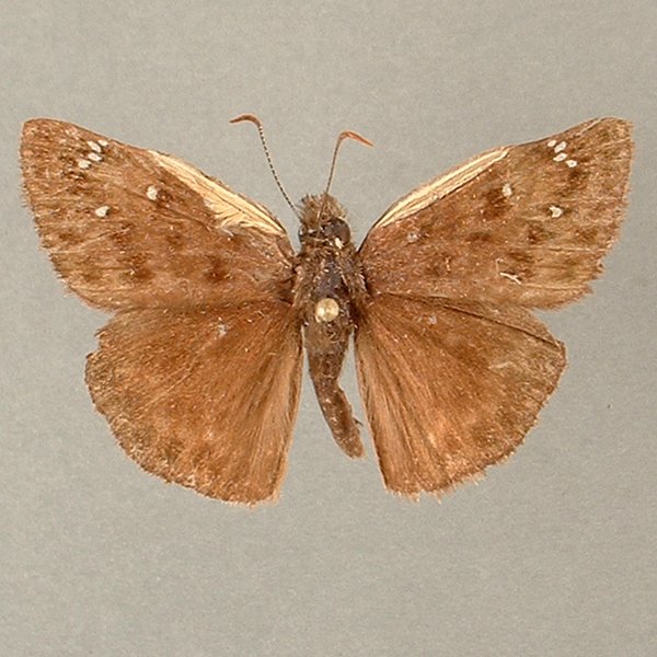
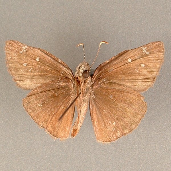
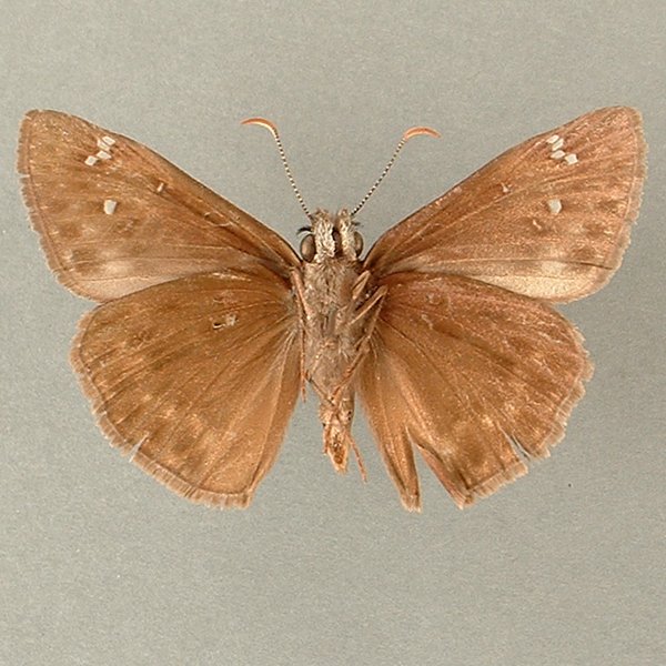
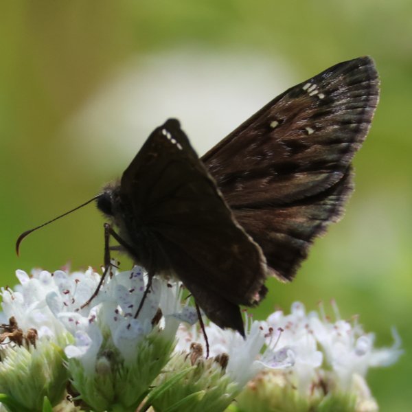
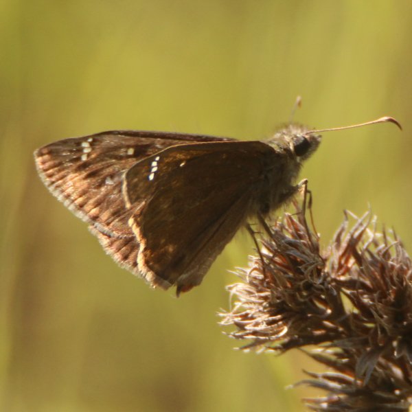
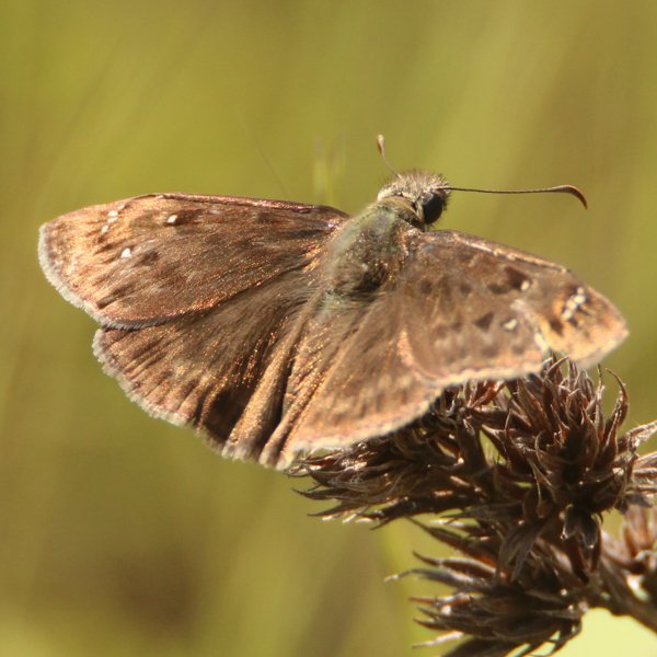
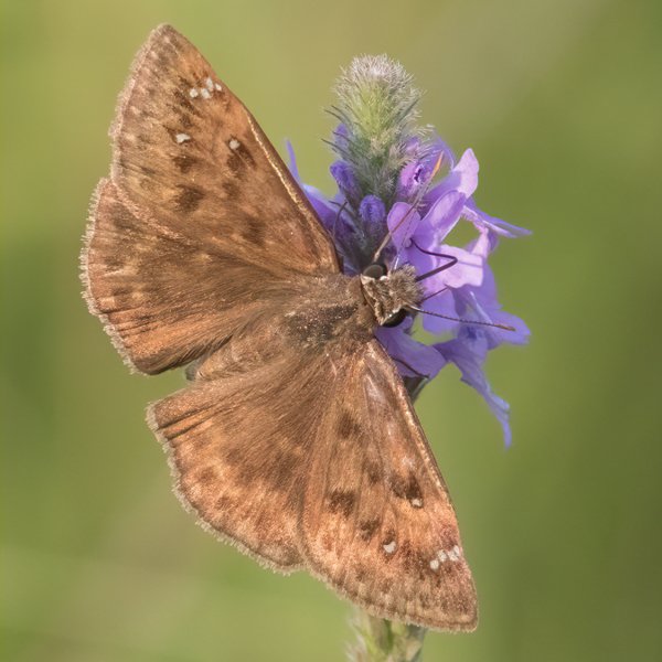
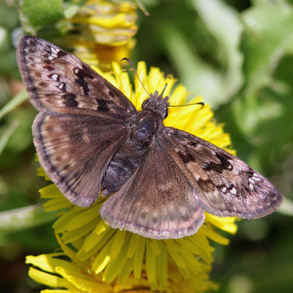
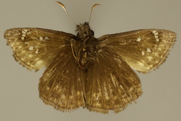
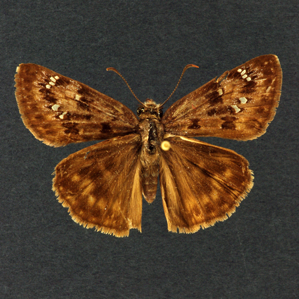
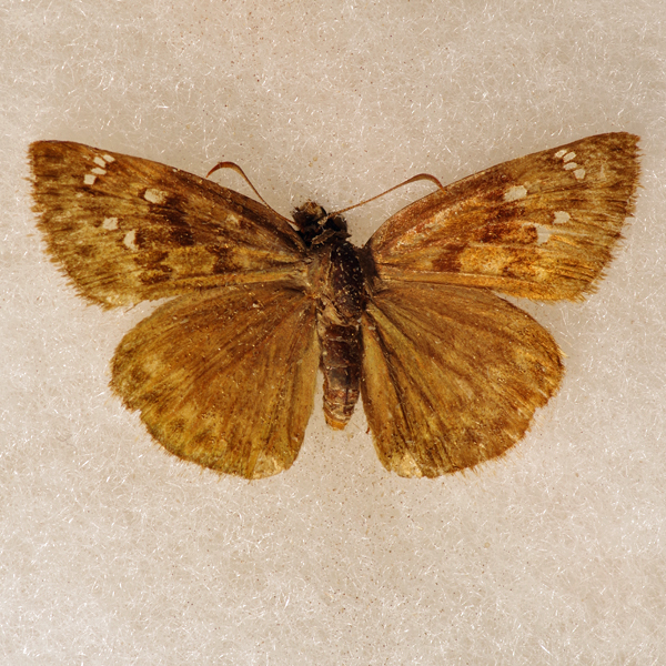
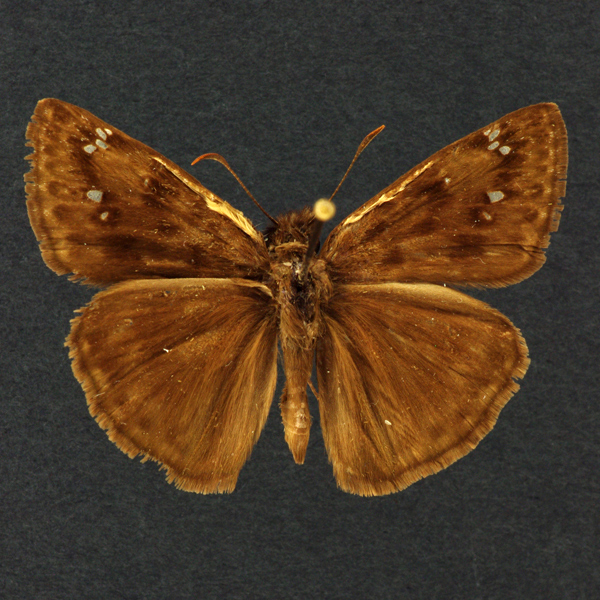
Wing span: 3.5 to 3.8 cm
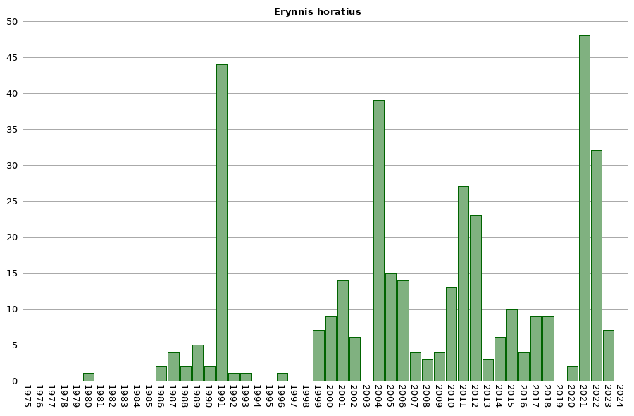
Flight time: Horace's Dustywing appears to be triple-brooded in Iowa, with the first brood flying from late April to early May, the second from early June to late July, and the third from mid August to early September.
Status: Uncommon breeding resident.
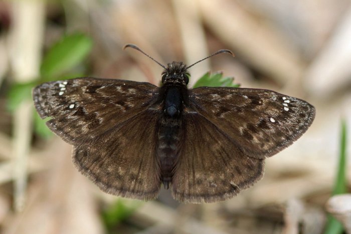
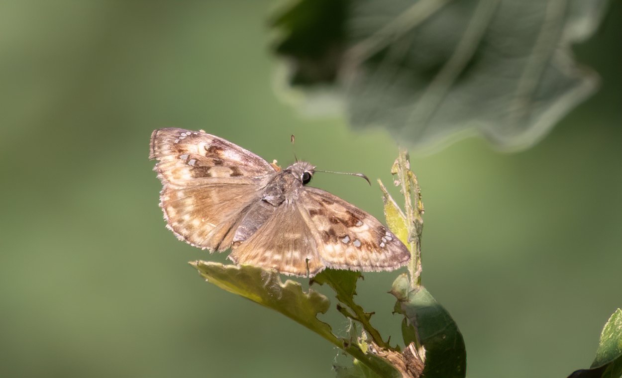
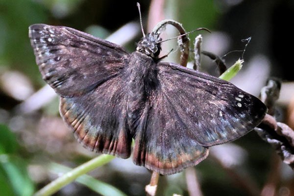
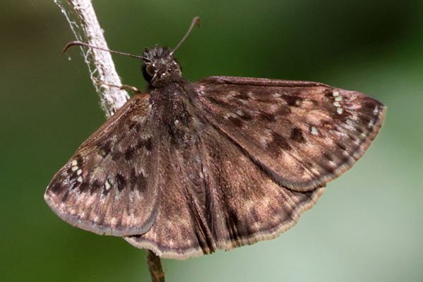
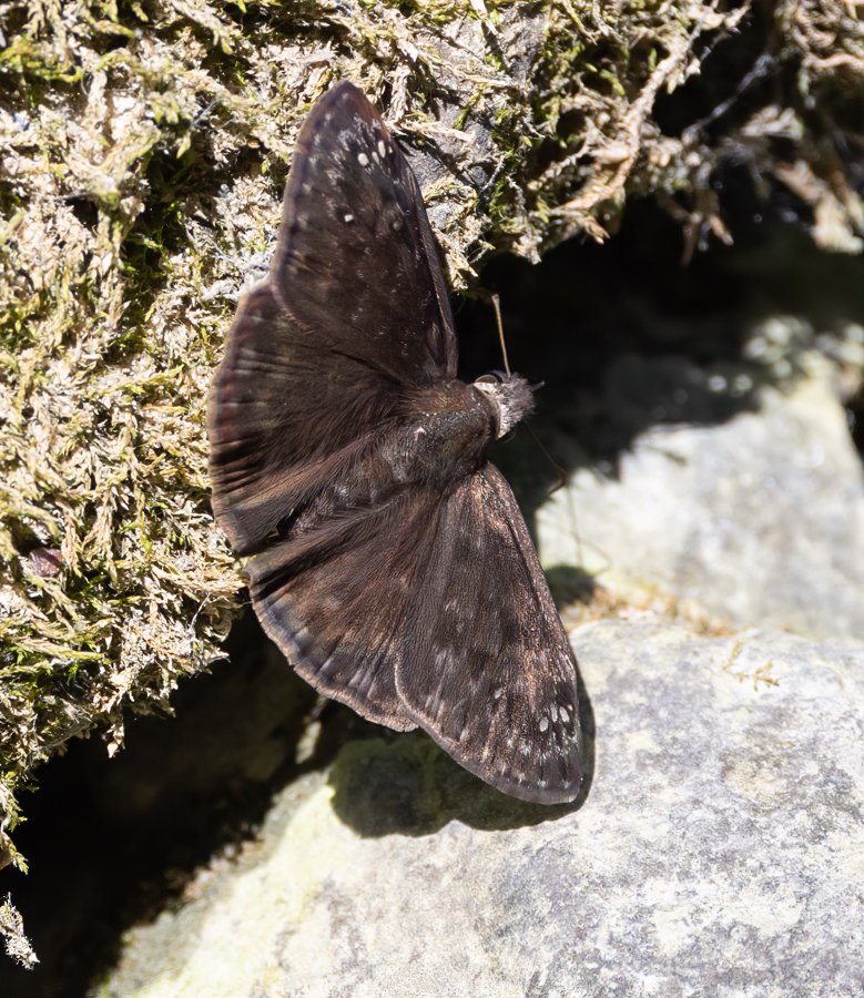
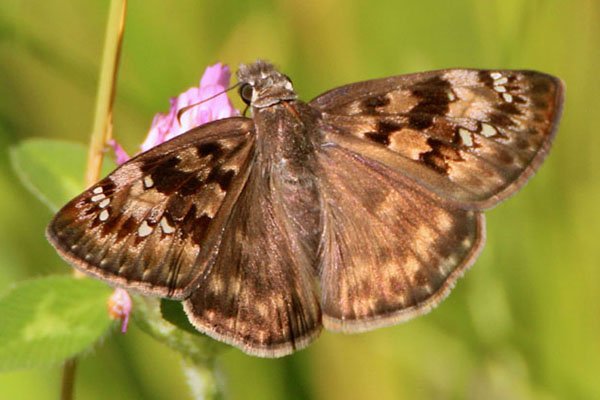
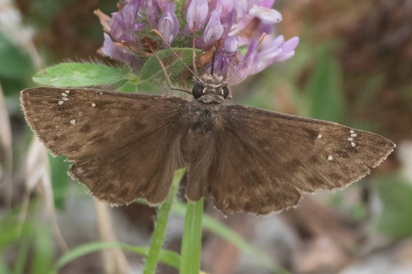
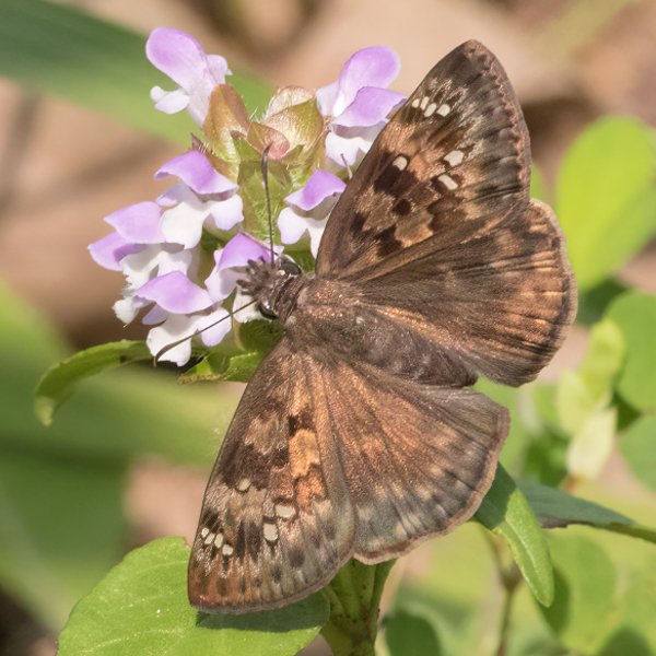
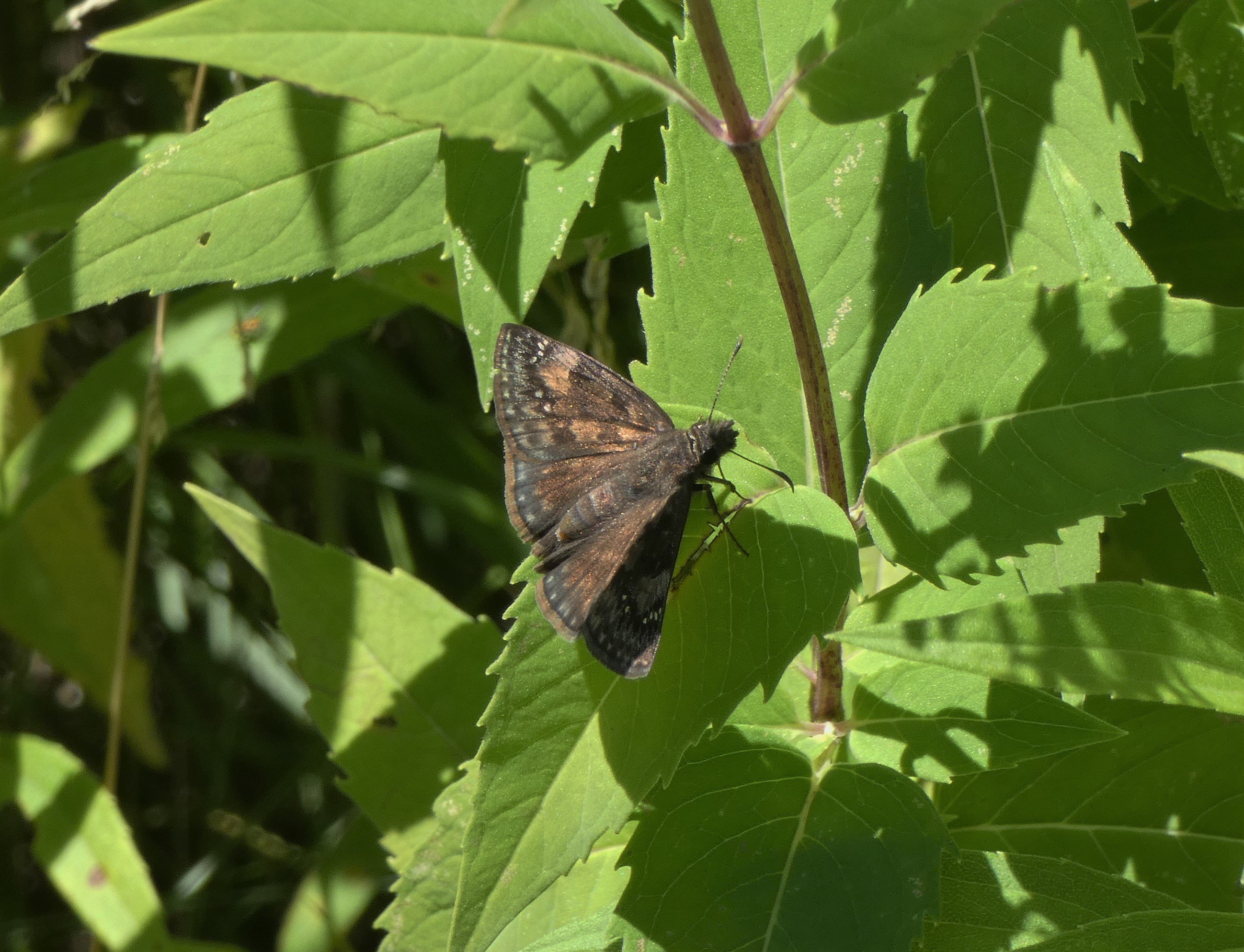
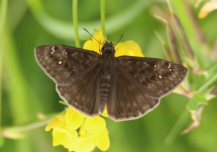
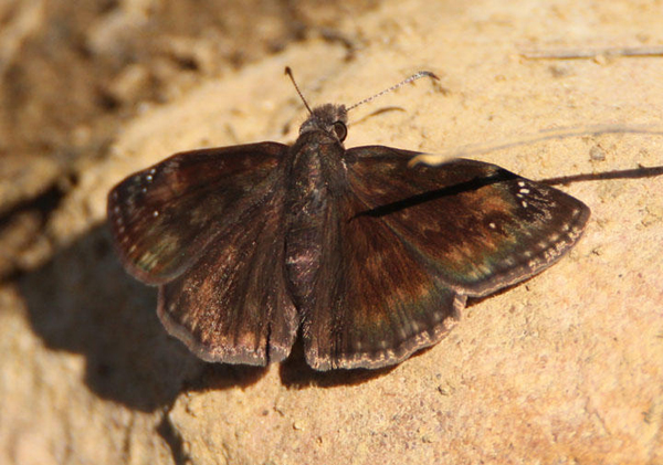
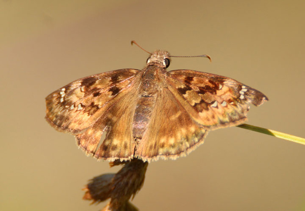
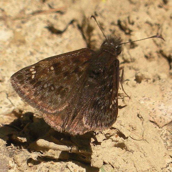
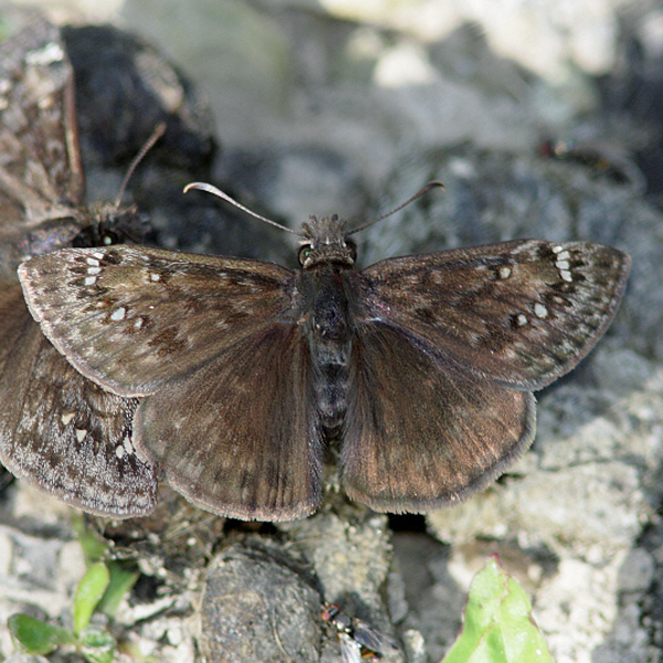
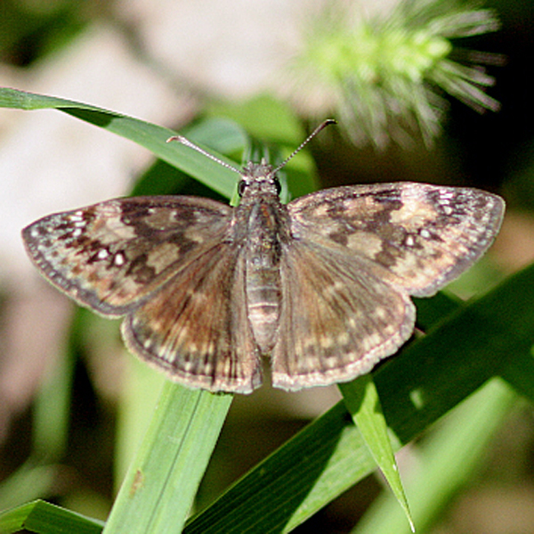
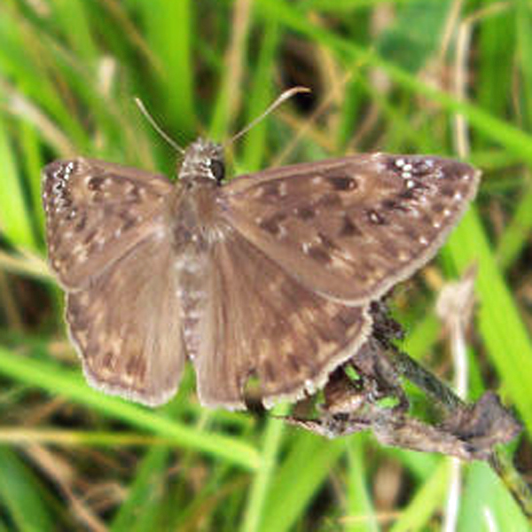
Distinguishing features: Erynnis horatius is close to E. juvenalis in appearance but is more uniformly brown and lacks the two sub-apical pale spots on the lower hindwing. The bulk of its flight occurs during the summer months; long after E. juvenalis has passed. Both of these species are larger than E. baptisiae and E. lucilius.
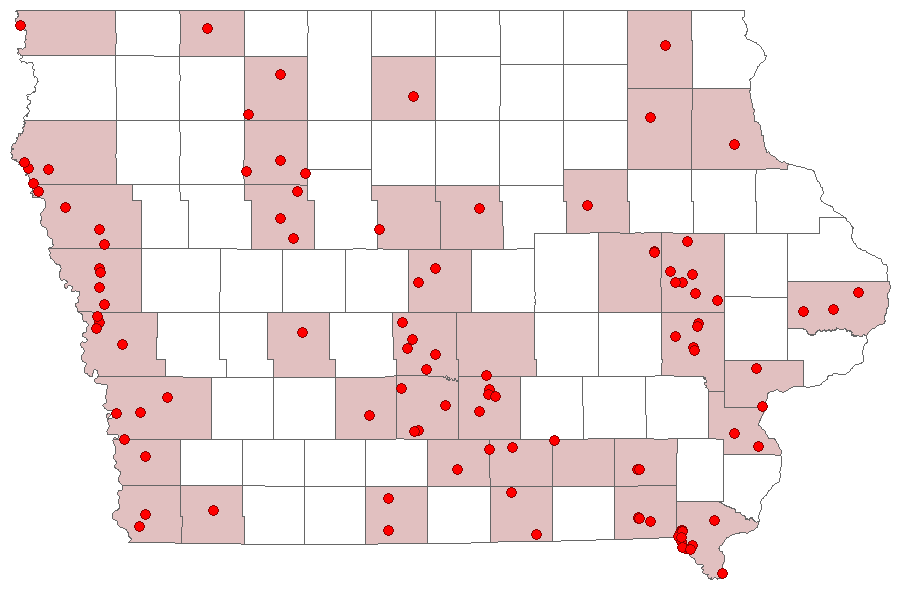
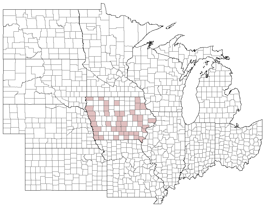
Distribution and habitat: This species is scattered and rare throughout the state. No clear habitat preferences have been noted, as it has been encountered from a wide variety of natural and altered habitats. In western Iowa it may be more common along oak-lined stream corridors.
Natural History: Although E. horatius has a wide distribution in the U. S., MacNeil (in Howe, 1975, p.525) notes that it is "almost absent from the Great Plains." Its larvae have been reported to eat various oak species.
**


| Record # | Date | Locale | State | Lat/Lon | Collected By | Count |
|---|---|---|---|---|---|---|
 368342 368342
|
2024-07-06 | Ringgold State Wildlife Area | Iowa | 40.595602 -94.137591 | Mark Madsen | 1 |
| 347058 | 2023-08-20 | Slip Bluff County Park | Iowa | 40.652884 -93.847544 | Jay Gilliam | 1 |
 345340 345340
|
2023-07-22 | MacBride Nature Recreation Area | Iowa | 41.786887861667 -91.56850911 | Mark Brown | 1 |
| 349970 | 2023-07-22 | MacBride Nature Recreation Area | Iowa | 41.786242 -91.566399 | Chris Edwards | 1 |
 346281 346281
|
2023-07-03 | Hidden Bridge Wildlife Area | Iowa | 43.420363 -96.565971 | Jay Gilliam | 1 |
 342731 342731
|
2023-06-25 | Shimek State Forest, Croton Unit East | Iowa | 40.546034 -91.615913 | Mark Brown | 1 |
 342732 342732
|
2023-06-25 | Shimek State Forest, Croton Unit East | Iowa | 40.546034 -91.615913 | Mark Brown | 1 |
 346240 346240
|
2023-06-25 | Shimek State Forest, Croton Unit East | Iowa | 40.546129 -91.616172 | Jay Gilliam | 2 |
| 350114 | 2023-06-25 | Shimek State Forest, Croton Unit East | Iowa | 40.545896 -91.616881 | Chris Edwards | 2 |
| 350169 | 2023-06-25 | Shimek State Forest, Donnellson Unit | Iowa | 40.643603 -91.67741 | Chris Edwards | 1 |
| 364335 | 2023-04-26 | Cedar View Trail | Iowa | 40.99102 -92.005082 | IBSN | 2 |
| 316812 | 2022-09-20 | Lowe Park | Iowa | 42.0677 -91.602248 | Frank Olsen | 1 |
| 318439 | 2022-08-20 | Slip Bluff County Park | Iowa | 40.652884 -93.847544 | Jay Gilliam | 4 |
| 318420 | 2022-08-14 | Slip Bluff County Park | Iowa | 40.652884 -93.847544 | Jay Gilliam | 4 |
| 318355 | 2022-08-07 | Red Rock Reservoir- Elk Rock Archery Range | Iowa | 41.407931 -93.108048 | Jay Gilliam | 6 |
| 318371 | 2022-08-07 | Elk Rock State Park | Iowa | 41.40032 -93.060454 | Jay Gilliam | 1 |
 318162 318162
|
2022-07-03 | Slip Bluff County Park | Iowa | 40.652884 -93.847544 | Jay Gilliam | 5 |
| 327829 | 2022-06-29 | Jefferson County Park | Iowa | 40.989906 -91.990814 | IBSN | 1 |
 313017 313017
|
2022-06-20 | Mt Vernon | Iowa | 41.9254 -91.417292 | laura iversen | 1 |
| 318001 | 2022-06-19 | Slip Bluff County Park | Iowa | 40.652884 -93.847544 | Jay Gilliam | 1 |
 315453 315453
|
2022-06-18 | Shimek State Forest, Donnellson Unit | Iowa | 40.64884 -91.679426 | Mark Brown | 1 |
| 331296 | 2022-06-18 | Shimek State Forest, Donnellson Unit | Iowa | 40.643603 -91.67741 | Chris Edwards | 5 |
| 331315 | 2022-06-18 | Shimek State Forest, Lick Creek Unit | Iowa | 40.61233 -91.685905 | Chris Edwards | 2 |
 296568 296568
|
2021-08-22 | Eddyville Sand Prairie Park | Iowa | 41.15397342 -92.61877466 | Mark Brown | 1 |
 296578 296578
|
2021-08-22 | Eddyville Sand Prairie Park | Iowa | 41.15397342 -92.61877466 | Mark Brown | 1 |
| 300896 | 2021-08-08 | Red Rock Reservoir- Hwy 14 & G28 | Iowa | 41.434442 -93.10052 | Jay Gilliam | 2 |
| 300890 | 2021-08-07 | Slip Bluff County Park | Iowa | 40.652884 -93.847544 | Jay Gilliam | 1 |
 300870 300870
|
2021-08-01 | Eddyville Sand Prairie Park | Iowa | 41.154568 -92.618726 | Jay Gilliam | 1 |
 300781 300781
|
2021-07-25 | Slip Bluff County Park | Iowa | 40.652884 -93.847545 | Jay Gilliam | 2 |
| 304271 | 2021-07-21 | Easter Lake | Iowa | 41.545422 -93.56662 | IBSN | 1 |
| 308351 | 2021-07-19 | Shimek State Forest, Croton Unit East | Iowa | 40.545896 -91.616881 | Chris Edwards | 6 |
| 308369 | 2021-07-19 | Shimek State Forest, Donnellson Unit | Iowa | 40.643603 -91.67741 | Chris Edwards | 1 |
| 308380 | 2021-07-19 | Shimek State Forest, Lick Creek Unit | Iowa | 40.61233 -91.685905 | Chris Edwards | 1 |
| 308392 | 2021-07-19 | Turkey Run Access | Iowa | 40.550644 -91.654633 | Chris Edwards | 1 |
| 308410 | 2021-07-19 | Turkey Run Wildlife Area, Lee County | Iowa | 40.558402 -91.679173 | Chris Edwards | 9 |
| 300768 | 2021-07-18 | Slip Bluff County Park | Iowa | 40.652884 -93.847544 | Jay Gilliam | 4 |
| 304273 | 2021-07-17 | Cedar View Trail | Iowa | 40.990459 -92.005459 | IBSN | 1 |
 300733 300733
|
2021-07-16 | Slip Bluff County Park | Iowa | 40.652884 -93.847544 | Jay Gilliam | 8 |
| 304272 | 2021-07-10 | Jefferson County Park | Iowa | 40.989906 -91.990814 | IBSN | 3 |
| 304274 | 2021-07-08 | Port Louisa National Wildlife Refuge, Horseshoe Bend | Iowa | 41.119631 -91.115408 | IBSN | 1 |
| 304275 | 2021-07-01 | Jefferson County Park | Iowa | 40.989906 -91.990814 | IBSN | 2 |
| 308007 | 2021-06-19 | Shimek State Forest, Croton Unit East | Iowa | 40.545896 -91.616881 | Chris Edwards | 2 |
 275162 275162
|
2020-07-28 | Slip Bluff County Park | Iowa | 40.652884 -93.847544 | Jay Gilliam | 1 |
 269337 269337
|
2020-07-10 | Hunter's Run Park | Iowa | 41.650341 -91.591034 | Mark Madsen | 1 |
| 223847 | 2018-08-04 | Rock Island Botanical State Preserve | Iowa | 42.025805 -91.72638 | Frank Olsen | 1 |
 225361 225361
|
2018-06-16 | Shimek State Forest, Lick Creek Unit | Iowa | 40.61983 -91.7085 | Mark Brown | 1 |
| 228603 | 2018-06-16 | Shimek State Forest Count Circle | Iowa | 40.588416 -91.686616 | Chris Edwards | 1 |
| 228627 | 2018-06-16 | Shimek State Forest, Croton Unit East | Iowa | 40.545896 -91.616881 | Chris Edwards | 1 |
| 228652 | 2018-06-16 | Shimek State Forest, Donnellson Unit | Iowa | 40.643603 -91.67741 | Chris Edwards | 5 |
 202617 202617
|
2017-07-30 | Slip Bluff County Park | Iowa | 40.65255 -93.84534 | Mark Brown | 1 |
| 202310 | 2017-07-06 | Decatur County, Iowa | Iowa | Location Protected | Sibylla Brown | 1 |
 202529 202529
|
2017-07-02 | Mockridge County Wildlife Reserve | Iowa | 41.869686 -90.784067 | Mark Brown | 1 |
| 202309 | 2017-07-01 | Decatur County, Iowa | Iowa | Location Protected | Sibylla Brown | 1 |
| 202308 | 2017-06-25 | Decatur County, Iowa | Iowa | Location Protected | Sibylla Brown | 1 |
| 202864 | 2017-06-24 | Shimek State Forest, Croton Unit East | Iowa | 40.545896 -91.616881 | Chris Edwards | 2 |
| 202865 | 2017-06-24 | Shimek State Forest, Donnellson Unit | Iowa | 40.643603 -91.67741 | Chris Edwards | 1 |
| 202307 | 2017-06-02 | Decatur County, Iowa | Iowa | Location Protected | Sibylla Brown | 1 |
| 182130 | 2016-06-19 | Decatur County, Iowa | Iowa | Location Protected | Sibylla Brown | 1 |
| 183822 | 2016-06-18 | Shimek State Forest Count Circle | Iowa | 40.588416 -91.686616 | Chris Edwards | 3 |
| 131396 | 2015-08-31 | Waubonsie State Park | Iowa | 40.676 -95.689 | Frank Olsen | 1 |
| 129318 | 2015-08-17 | Big Creek State Park | Iowa | 41.807055 -93.745185 | Mark Brown | 6 |
| 136348 | 2015-07-12 | Decatur County, Iowa | Iowa | Location Protected | Sibylla Brown | 1 |
| 183512 | 2015-06-21 | Shimek State Forest, Croton Unit East | Iowa | 40.545896 -91.616881 | Chris Edwards | 2 |
| 109632 | 2014-09-02 | Gleason-Hubel Wildlife Area | Iowa | 41.77583 -96.00733 | Frank Olsen | 2 |
| 109954 | 2014-09-01 | Loess Hills Scenic Overlook | Iowa | 41.904962 -95.945821 | Frank Olsen | 1 |
| 114638 | 2014-07-19 | F. W. Kent Park | Iowa | 41.72916 -91.727161 | Chris Edwards | 1 |
| 114648 | 2014-07-03 | Shimek State Forest, Donnellson Unit | Iowa | 40.643603 -91.67741 | Chris Edwards | 2 |
| 8388 | 2013-08-25 | Sedan Bottoms Wildlife Management Area | Iowa | 40.63 -92.755 | Tom Jantscher | 1 |
| 55051 | 2013-05-14 | Turkey Run Access | Iowa | 40.550592 -91.654215 | Frank Olsen | 1 |
 8397 8397
|
2013-05-12 | Shimek State Forest, Donnellson Unit | Iowa | 40.6427778 -91.6936111 | Tom Jantscher | 1 |
| 8391 | 2012-09-03 | Shimek State Forest, Donnellson Unit | Iowa | 40.6502778 -91.6866667 | Tom Jantscher | 1 |
| 8392 | 2012-09-03 | Shimek State Forest, Donnellson Unit | Iowa | 40.6502778 -91.6866667 | Tom Jantscher | 1 |
| 8393 | 2012-09-03 | Rand Park, Keokuk | Iowa | 40.4105556 -91.3811111 | Tom Jantscher | 1 |
| 114620 | 2012-09-03 | Rand Park, Keokuk | Iowa | 40.410932 -91.381383 | Chris Edwards | 3 |
| 114636 | 2012-09-03 | Shimek State Forest, Donnellson Unit | Iowa | 40.643603 -91.67741 | Chris Edwards | 2 |
| 114627 | 2012-06-25 | Shimek State Forest, Croton Unit East | Iowa | 40.545896 -91.616881 | Chris Edwards | 3 |
| 114635 | 2012-06-25 | Shimek State Forest, Donnellson Unit | Iowa | 40.643603 -91.67741 | Chris Edwards | 6 |
| 8406 | 2012-04-21 | Lacey-Keosauqua State Park | Iowa | 40.7252778 -91.9988889 | Tom Jantscher | 1 |
| 8407 | 2012-04-21 | Lacey-Keosauqua State Park | Iowa | 40.72 -91.9983333 | Tom Jantscher | 1 |
| 8408 | 2012-04-21 | Lacey-Keosauqua State Park | Iowa | 40.7219444 -91.9986111 | Tom Jantscher | 1 |
| 8409 | 2012-04-21 | Lacey-Keosauqua State Park | Iowa | 40.7236111 -91.9980556 | Tom Jantscher | 1 |
 207893 207893
|
2012-04-01 | Stephens State Forest - Thousand Acre Unit, Lucas County | Iowa | 41.103003 -93.101751 | Aaron Brees | 1 |
 207894 207894
|
2012-04-01 | Stephens State Forest - Thousand Acre Unit, Lucas County | Iowa | 41.103003 -93.101751 | Aaron Brees | 1 |
| 3002 | 2011-07-25 | Monroe County | Iowa | 41.1147421 -92.934655 | BAMONA | 1 |
| 6819 | 2011-07-24 | Sylvan Runkel State Preserve | Iowa | 42.105 -95.98233 | Aaron Brees | 1 |
| 55027 | 2011-07-17 | Hitaga Sand Ridge Prairie Preserve | Iowa | 42.25233 -91.63633 | Frank Olsen | 1 |
| 114626 | 2011-07-04 | Shimek State Forest, Croton Unit East | Iowa | 40.545896 -91.616881 | Chris Edwards | 14 |
| 114634 | 2011-07-04 | Shimek State Forest, Donnellson Unit | Iowa | 40.643603 -91.67741 | Chris Edwards | 5 |
| 114647 | 2011-07-04 | Shimek State Forest, Donnellson Unit | Iowa | 40.643603 -91.67741 | Chris Edwards | 1 |
| 8404 | 2011-06-19 | Wickiup Hill Outdoor Learning Area | Iowa | 42.085 -91.7666667 | Tom Jantscher | 1 |
 207892 207892
|
2011-06-11 | Boone Forks Wildlife Management Area | Iowa | 42.315812 -93.915629 | Aaron Brees | 1 |
| 8394 | 2011-05-08 | Shimek State Forest, Croton Unit East | Iowa | 40.54708 -91.620635 | Tom Jantscher | 1 |
| 8396 | 2011-05-08 | Shimek State Forest, Donnellson Unit | Iowa | 40.6463889 -91.6863889 | Tom Jantscher | 1 |
 207895 207895
|
2010-09-04 | Folsom Point Preserve | Iowa | 41.16139 -95.795 | Aaron Brees | 1 |
| 8398 | 2010-08-15 | Shimek State Forest, Croton Unit East | Iowa | 40.5686111 -91.6038889 | Tom Jantscher | 1 |
| 114625 | 2010-08-15 | Shimek State Forest, Croton Unit East | Iowa | 40.545896 -91.616881 | Chris Edwards | 1 |
| 6817 | 2010-07-25 | Slip Bluff County Park | Iowa | 40.65255 -93.84534 | Aaron Brees | 2 |
| 8395 | 2010-07-10 | Shimek State Forest, Donnellson Unit | Iowa | 40.6463889 -91.6863889 | Tom Jantscher | 1 |
| 55052 | 2010-07-02 | Waubonsie State Park | Iowa | 40.676 -95.689 | Frank Olsen | 1 |
| 55053 | 2010-07-02 | Waubonsie State Park | Iowa | 40.676 -95.689 | Frank Olsen | 1 |
| 114624 | 2010-07-01 | Shimek State Forest, Croton Unit East | Iowa | 40.545896 -91.616881 | Chris Edwards | 3 |
| 114633 | 2010-07-01 | Shimek State Forest, Donnellson Unit | Iowa | 40.643603 -91.67741 | Chris Edwards | 1 |
 264685 264685
|
2010-06-04 | Cranesville Swamp Natural Area | West Virginia | 39.534999 -79.483655 | Jim Durbin | 1 |
| 114623 | 2009-06-22 | Shimek State Forest, Croton Unit East | Iowa | 40.545896 -91.616881 | Chris Edwards | 1 |
| 114632 | 2009-06-22 | Shimek State Forest, Donnellson Unit | Iowa | 40.643603 -91.67741 | Chris Edwards | 2 |
| 114646 | 2009-06-22 | Shimek State Forest, Donnellson Unit | Iowa | 40.643603 -91.67741 | Chris Edwards | 1 |
 138221 138221
|
2008-07-30 | Decatur Wildlife Management Area | Iowa | 40.830629 -93.85059 | Aaron Brees | 1 |
 207896 207896
|
2008-07-30 | Decatur Wildlife Management Area | Iowa | 40.830629 -93.85059 | Aaron Brees | 1 |
 207897 207897
|
2008-07-30 | Decatur Wildlife Management Area | Iowa | 40.830629 -93.85059 | Aaron Brees | 1 |
| 55050 | 2007-09-13 | Story County | Iowa | 42.10405 -93.50034 | MJ Hatfield | 1 |
| 55036 | 2007-07-30 | Manikowski Prairie State Preserve | Iowa | 41.972843 -90.375383 | Frank Olsen | 1 |
| 114643 | 2007-07-01 | MacBride Nature Recreation Area | Iowa | 41.786242 -91.566399 | Chris Edwards | 1 |
| 114622 | 2007-06-15 | Shimek State Forest, Croton Unit East | Iowa | 40.545896 -91.616881 | Chris Edwards | 1 |
 275470 275470
|
2006-08-20 | Saylorville Visitor Center | Iowa | 41.710399 -93.67038 | Jay Gilliam | 1 |
| 55022 | 2006-08-07 | Blue Flag Marsh | Iowa | 41.441 -93.75533 | Frank Olsen | 1 |
| 55037 | 2006-07-22 | Medora Prairie | Iowa | 41.209512 -93.627408 | Frank Olsen | 1 |
| 55020 | 2006-07-07 | Blue Flag Marsh | Iowa | 41.441 -93.75533 | Dennis Schlicht | 2 |
| 114621 | 2006-06-24 | Shimek State Forest, Croton Unit East | Iowa | 40.545896 -91.616881 | Chris Edwards | 3 |
| 114631 | 2006-06-24 | Shimek State Forest, Donnellson Unit | Iowa | 40.643603 -91.67741 | Chris Edwards | 1 |
| 107032 | 2006-06-07 | Brush Creek Wetland | Iowa | 41.5123 -93.1269 | Dennis Schlicht | 1 |
| 107033 | 2006-06-07 | Brush Creek Wetland | Iowa | 41.51367 -93.12767 | Frank Olsen | 1 |
| 55021 | 2006-05-26 | Blue Flag Marsh | Iowa | 41.441 -93.75533 | Frank Olsen | 1 |
| 55046 | 2006-05-06 | Shimek State Forest, Croton Unit East | Iowa | 40.54693 -91.61435 | Doug Veal | 1 |
| 55054 | 2006-04-26 | Waubonsie State Park | Iowa | 40.676 -95.689 | Frank Olsen | 1 |
 144031 144031
|
2005-08-20 | Terra Park | Iowa | 41.661202 -93.705061 | Mark Brown | 1 |
| 114629 | 2005-07-02 | Shimek State Forest Count Circle | Iowa | 40.588416 -91.686616 | Chris Edwards | 14 |
| 55026 | 2004-07-26 | Five Ridge Prairie State Preserve | Iowa | 42.67867 -96.53473 | Jen Vogel | 1 |
| 114619 | 2004-07-25 | Rand Park, Keokuk | Iowa | 40.410932 -91.381383 | Chris Edwards | 1 |
| 55024 | 2004-07-16 | Five Ridge Prairie State Preserve | Iowa | 42.67867 -96.53473 | Jen Vogel | 1 |
| 55025 | 2004-07-14 | Five Ridge Prairie State Preserve | Iowa | 42.67867 -96.53473 | Jen Vogel | 1 |
| 352860 | 2004-07-12 | Anderson Prairie, Decorah | Iowa | 43.315099 -91.800701 | Kirk J. Larsen | 1 |
| 55023 | 2004-07-11 | Five Ridge Prairie State Preserve | Iowa | 42.6496 -96.5032 | Jen Vogel | 1 |
| 114628 | 2004-06-19 | Shimek State Forest Count Circle | Iowa | 40.588416 -91.686616 | Chris Edwards | 33 |
| 55041 | 2002-09-11 | Rock Island Botanical State Preserve | Iowa | 42.02732 -91.72723 | Frank Olsen | 1 |
| 144536 | 2002-09-11 | Rock Island Botanical State Preserve | Iowa | 42.026205 -91.726516 | Frank Olsen | 1 |
| 114618 | 2002-08-11 | Rand Park, Keokuk | Iowa | 40.410932 -91.381383 | Chris Edwards | 2 |
| 55040 | 2002-08-03 | Rock Island Botanical State Preserve | Iowa | 42.02732 -91.72723 | Frank Olsen | 1 |
| 144531 | 2002-08-03 | Rock Island Botanical State Preserve | Iowa | 42.026205 -91.726516 | Frank Olsen | 1 |
| 55030 | 2001-09-10 | Honey Creek State Park | Iowa | 40.86526 -92.94011 | Frank Olsen | 1 |
| 55032 | 2001-08-28 | Honey Creek State Park | Iowa | 40.86526 -92.94011 | Frank Olsen | 1 |
| 114642 | 2001-08-28 | MacBride Nature Recreation Area | Iowa | 41.786242 -91.566399 | Chris Edwards | 1 |
| 114645 | 2001-08-28 | Lake MacBride State Park | Iowa | 41.800146 -91.555669 | Chris Edwards | 2 |
| 55055 | 2001-08-23 | Woodland Mounds State Preserve | Iowa | 41.34618 -93.4281 | Stephanie Shepherd | 1 |
| 114641 | 2001-08-18 | MacBride Nature Recreation Area | Iowa | 41.786242 -91.566399 | Chris Edwards | 1 |
| 55028 | 2001-08-14 | Honey Creek State Park | Iowa | 40.86526 -92.94011 | Dennis Schlicht | 1 |
| 55031 | 2001-08-14 | Honey Creek State Park | Iowa | 40.86526 -92.94011 | Frank Olsen | 1 |
| 114640 | 2001-08-08 | MacBride Nature Recreation Area | Iowa | 41.786242 -91.566399 | Chris Edwards | 1 |
| 55029 | 2001-08-05 | Honey Creek State Park | Iowa | 40.86526 -92.94011 | Dennis Schlicht | 1 |
| 114617 | 2001-08-05 | Rand Park, Keokuk | Iowa | 40.410932 -91.381383 | Chris Edwards | 1 |
| 55042 | 2001-07-30 | Rolling Thunder Prairie State Preserve | Iowa | 41.2042 -93.656 | Stephanie Shepherd | 1 |
| 114637 | 2001-05-11 | Wiese Slough State Game Management Area | Iowa | 41.550678 -91.130607 | Chris Edwards | 1 |
| 144512 | 2000-08-16 | Rock Island Botanical State Preserve | Iowa | 42.026205 -91.726516 | Frank Olsen | 1 |
| 248505 | 2000-08-16 | Wickiup Hill Outdoor Learning Area | Iowa | 42.08398 -91.7651 | Frank Olsen | 1 |
| 55039 | 2000-08-11 | Rock Island Botanical State Preserve | Iowa | 42.02732 -91.72723 | Frank Olsen | 1 |
| 144510 | 2000-08-11 | Rock Island Botanical State Preserve | Iowa | 42.026205 -91.726516 | Frank Olsen | 1 |
| 55038 | 2000-07-27 | Rock Island Botanical State Preserve | Iowa | 42.02732 -91.72723 | Frank Olsen | 1 |
| 144503 | 2000-07-27 | Rock Island Botanical State Preserve | Iowa | 42.026205 -91.726516 | Frank Olsen | 1 |
| 114644 | 2000-07-22 | Lake MacBride State Park | Iowa | 41.800146 -91.555669 | Chris Edwards | 1 |
 25897 25897
|
2000-07-17 | Shimek State Forest, Croton Unit East | Iowa | 40.54693 -91.61435 | Jim Durbin | 1 |
| 144492 | 2000-07-07 | Wickiup Hill Outdoor Learning Area | Iowa | 42.08398 -91.7651 | Frank Olsen | 1 |
 137178 137178
|
1999-08-13 | Guthrie County | Iowa | 41.75309 -94.479973 | Paul Martsching | 1 |
| 114639 | 1999-07-18 | MacBride Nature Recreation Area | Iowa | 41.786242 -91.566399 | Chris Edwards | 1 |
 144482 144482
|
1999-07-17 | Indian Creek Nature Center | Iowa | 41.96611 -91.57934 | Frank Olsen | 1 |
| 114630 | 1999-07-10 | Shimek State Forest, Lick Creek Unit | Iowa | 40.61233 -91.685905 | Chris Edwards | 4 |
 137187 137187
|
1996-08-13 | Brookside Park, Ames | Iowa | 42.02613 -93.6294 | Paul Martsching | 1 |
| 107021 | 1993-08-28 | Big Sand Mound Prairie Preserve, Muscatine County | Iowa | 41.341015 -91.086545 | Frank Olsen | 1 |
| 107030 | 1992-05-09 | Mount Talbot State Preserve | Iowa | 42.56481 -96.47028 | Tim Orwig | 1 |
| 55035 | 1991-08-31 | Loess Hills Wildlife Management Area | Iowa | 42.08 -95.9765 | Tim Orwig | 1 |
| 55034 | 1991-08-30 | Loess Hills Wildlife Management Area | Iowa | 42.08 -95.9765 | Tim Orwig | 1 |
| 107034 | 1991-07-29 | Cooper's Cove County Park | Iowa | 42.624323 -94.464394 | Ron Harms | 1 |
| 107035 | 1991-06-15 | Sunken Grove State Game Management Area | Iowa | 42.63 -94.896134 | Ron Harms | 1 |
| 107036 | 1991-06-15 | Sunken Grove State Game Management Area | Iowa | 42.63 -94.896134 | Ron Harms | 1 |
| 107037 | 1991-06-15 | Sunken Grove State Game Management Area | Iowa | 42.63 -94.896134 | Ron Harms | 1 |
| 55044 | 1991-06-11 | Rush Lake / Salton Park | Iowa | 42.94033 -94.88517 | Ron Harms | 1 |
| 55045 | 1991-06-11 | Rush Lake / Salton Park | Iowa | 42.94033 -94.88517 | Ron Harms | 1 |
| 55043 | 1991-05-11 | Manson | Iowa | 42.526034 -94.520739 | Ron Harms | 1 |
| 271943 | 1991-05-11 | Lohrville | Iowa | 42.269681 -94.545958 | Ron Harms | 34 |
| 144346 | 1991-05-07 | Rock Island Botanical State Preserve | Iowa | 42.026205 -91.726516 | Frank Olsen | 1 |
| 107026 | 1990-09-08 | Murray Hill Scenic Overlook | Iowa | 41.837431 -96.0008 | Tim Orwig | 1 |
| 107027 | 1990-09-08 | Murray Hill Scenic Overlook | Iowa | 41.837431 -96.0008 | Tim Orwig | 1 |
| 107025 | 1989-07-11 | Loess Hills State Forest, Little Sioux Unit | Iowa | 41.809303 -95.982717 | Tim Orwig | 1 |
 10862 10862
|
1989-07-01 | Tim Orwig Specimen No data-x | Iowa | 42.64444 -96.35806 | Tim Orwig | 1 |
| 107022 | 1989-07-01 | Harrison County | Iowa | 41.68714 -95.810212 | Tim Orwig | 1 |
| 107023 | 1989-07-01 | Harrison County | Iowa | 41.68714 -95.810212 | Tim Orwig | 1 |
| 107024 | 1989-07-01 | Harrison County | Iowa | 41.68714 -95.810212 | Tim Orwig | 1 |
| 107028 | 1988-07-17 | Fowler Forest Preserve | Iowa | 42.232523 -95.945211 | Tim Orwig | 1 |
| 107029 | 1988-06-26 | Anthony Pope Prairie | Iowa | 42.438477 -96.23305 | Tim Orwig | 1 |
| 55047 | 1987-07-16 | Shimek State Forest, Croton Unit East | Iowa | 40.54693 -91.61435 | Dennis Schlicht | 1 |
| 124006 | 1987-06-27 | Wildcat Bluff Recreational Area | Iowa | 42.193767 -91.883089 | Frank Olsen | 1 |
| 144190 | 1987-06-27 | Wildcat Bluff Recreational Area | Iowa | 42.190477 -91.882811 | Frank Olsen | 1 |
| 55033 | 1987-05-02 | Lacey-Keosauqua State Park | Iowa | 40.71688 -91.9908 | Dennis Schlicht | 1 |
| 55048 | 1986-07-05 | Sioux City State Prairie Preserve | Iowa | 42.5241 -96.4362 | Tim Orwig | 1 |
| 55049 | 1986-07-05 | Sioux City State Prairie Preserve | Iowa | 42.5241 -96.4362 | Tim Orwig | 1 |
| 107038 | 1980-07-02 | Lewis and Clark Park | Iowa | 41.305465 -95.860257 | Dennis Schlicht | 1 |
| 2984 | 1950-07-01 | Black Hawk County | Iowa | 42.447803 -92.381363 | USGS - NPWRC | 1 |
| 2985 | 1950-07-01 | Calhoun County | Iowa | 42.37859 -94.645035 | USGS - NPWRC | 1 |
| 2986 | 1950-07-01 | Clayton County | Iowa | 42.77853 -91.289101 | USGS - NPWRC | 1 |
| 2987 | 1950-07-01 | Clinton County | Iowa | 41.878563 -90.563606 | USGS - NPWRC | 1 |
| 2988 | 1950-07-01 | Dickinson County | Iowa | 43.404938 -95.184921 | USGS - NPWRC | 1 |
| 2989 | 1950-07-01 | Fayette County | Iowa | 42.925819 -91.909927 | USGS - NPWRC | 1 |
| 2990 | 1950-07-01 | Sidney | Iowa | 40.74004 -95.645798 | USGS - NPWRC | 1 |
| 2991 | 1950-07-01 | Hancock County | Iowa | 43.038731 -93.662323 | USGS - NPWRC | 1 |
| 2992 | 1950-07-01 | Hardin County | Iowa | 42.428543 -93.177963 | USGS - NPWRC | 1 |
| 2993 | 1950-07-01 | Johnson County | Iowa | 41.669899 -91.598396 | USGS - NPWRC | 1 |
| 2994 | 1950-07-01 | Lee County | Iowa | 40.706867 -91.443466 | USGS - NPWRC | 1 |
| 2995 | 1950-07-01 | Linn County | Iowa | 42.027289 -91.67275 | USGS - NPWRC | 1 |
| 2996 | 1950-07-01 | Louisa County | Iowa | 41.193298 -91.289101 | USGS - NPWRC | 1 |
| 2997 | 1950-07-01 | Lucas County | Iowa | 40.991203 -93.33889 | USGS - NPWRC | 1 |
| 2998 | 1950-07-01 | Madison County | Iowa | 41.292236 -93.987846 | USGS - NPWRC | 1 |
| 2999 | 1950-07-01 | Marion County | Iowa | 41.317383 -93.177963 | USGS - NPWRC | 1 |
| 3000 | 1950-07-01 | Mills County | Iowa | 41.06245 -95.645798 | USGS - NPWRC | 1 |
| 3001 | 1950-07-01 | Monona County | Iowa | 42.001595 -95.983261 | USGS - NPWRC | 1 |
| 3003 | 1950-07-01 | Page County | Iowa | 40.763512 -95.143204 | USGS - NPWRC | 1 |
| 3004 | 1950-07-01 | Palo Alto County | Iowa | 43.158089 -94.645035 | USGS - NPWRC | 1 |
| 3005 | 1950-07-01 | Pocahontas County | Iowa | 42.691803 -94.645035 | USGS - NPWRC | 1 |
| 3006 | 1950-07-01 | Polk County | Iowa | 41.627842 -93.500343 | USGS - NPWRC | 1 |
| 3007 | 1950-07-01 | Pottawattamie County | Iowa | 41.391151 -95.477783 | USGS - NPWRC | 1 |
| 3008 | 1950-07-01 | Van Buren County | Iowa | 40.700115 -91.909927 | USGS - NPWRC | 1 |
| 3009 | 1950-07-01 | Woodbury County | Iowa | 42.316616 -95.983261 | USGS - NPWRC | 1 |
| 107020 | 1950-07-01 | Pottawattamie County | Iowa | 41.308529 -95.680399 | Tim Orwig | 1 |
| 107031 | 1934-08-06 | Dickinson County, Iowa | Iowa | Location Protected | 1 |