Wing span:
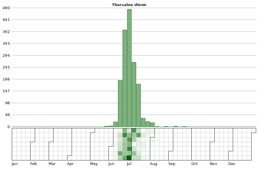
Flight time:Mid-June through July.
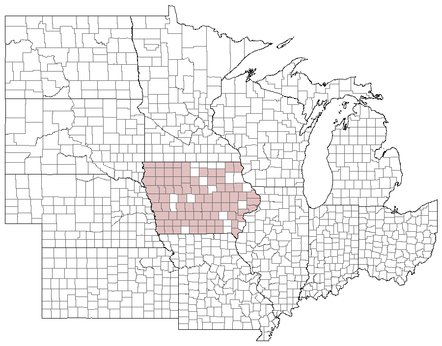
Status: Breeding resident.
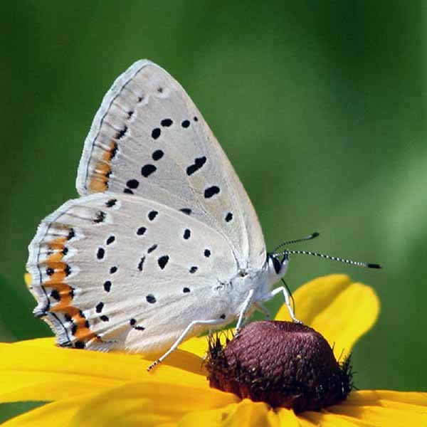
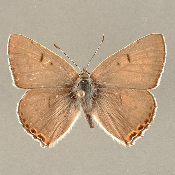
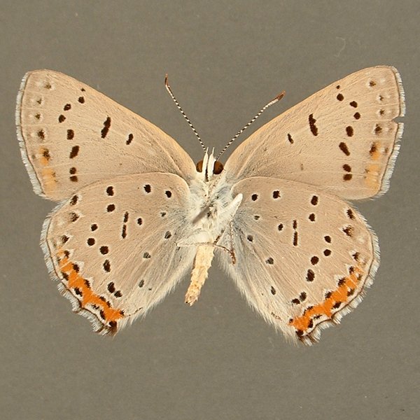
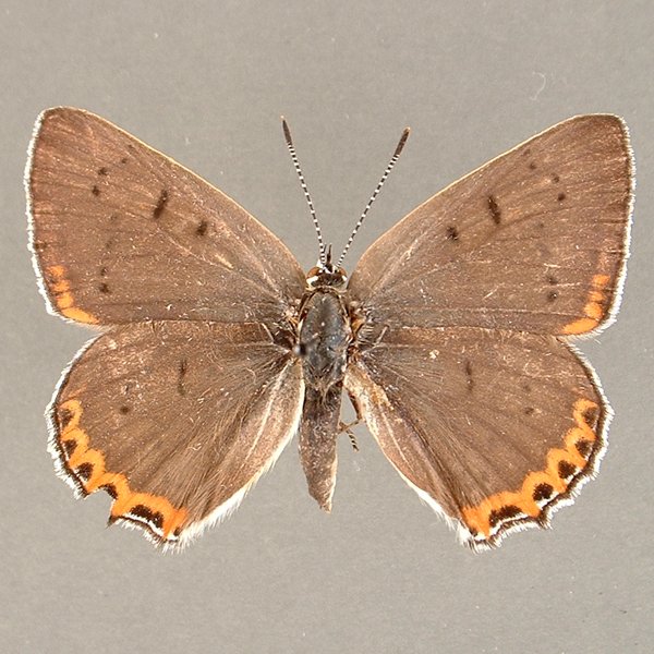
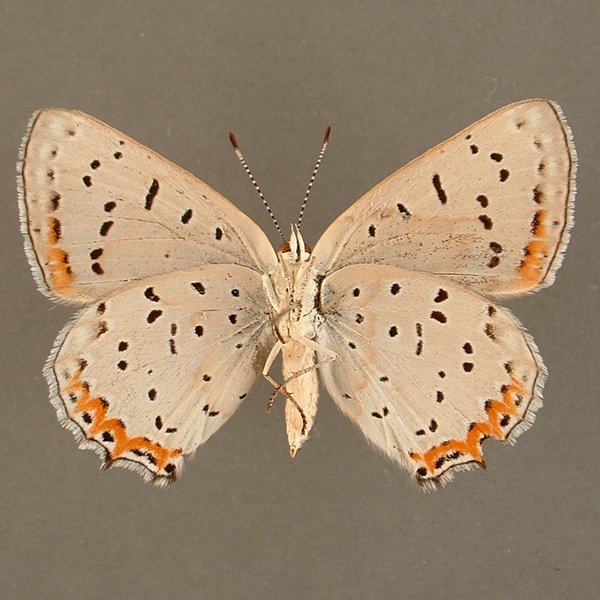
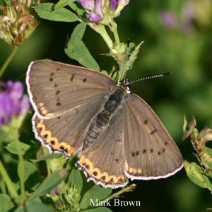
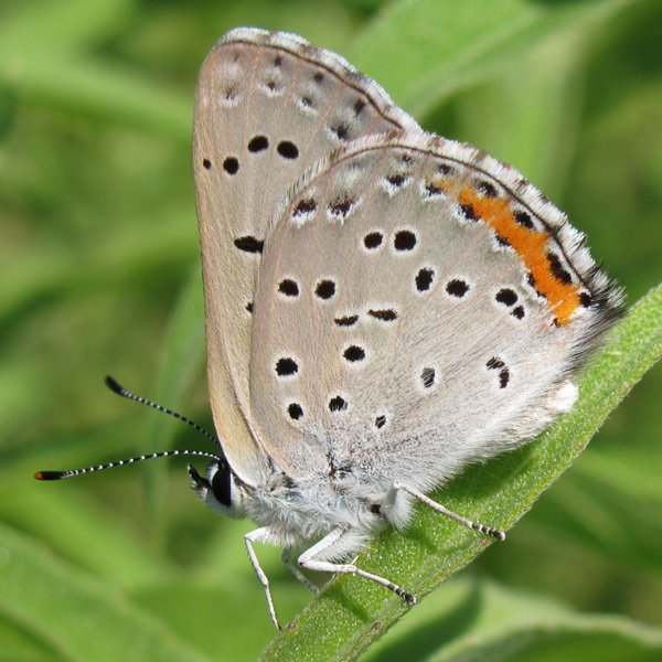
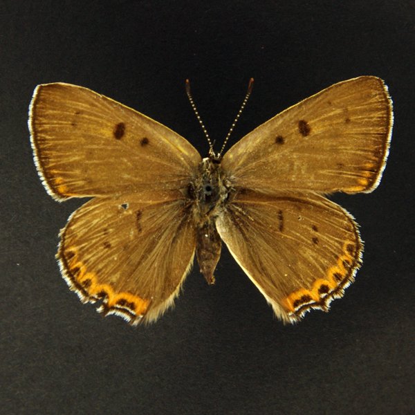
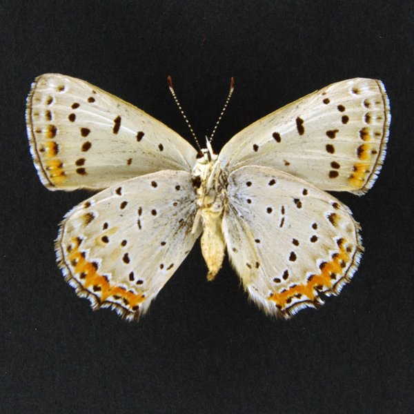
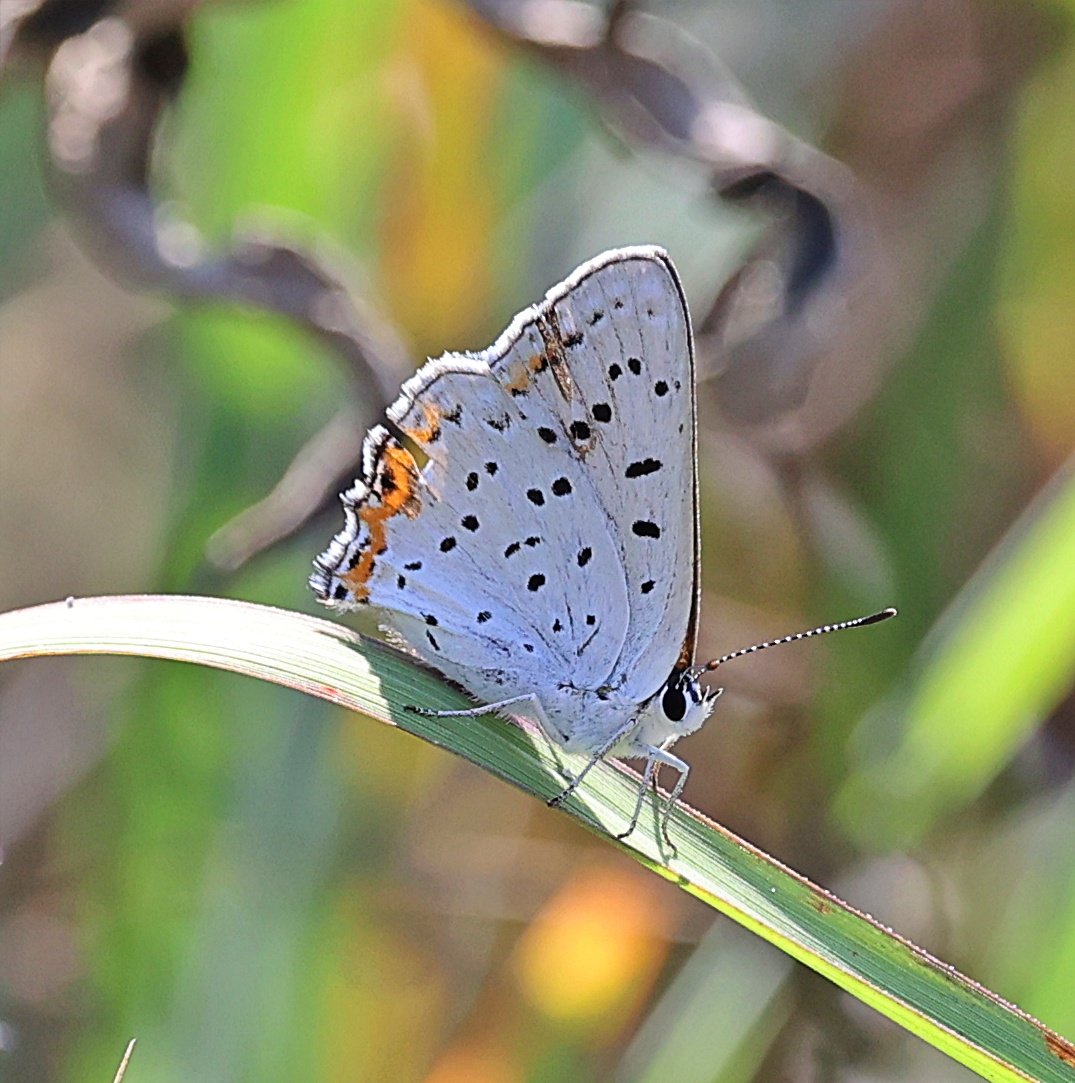
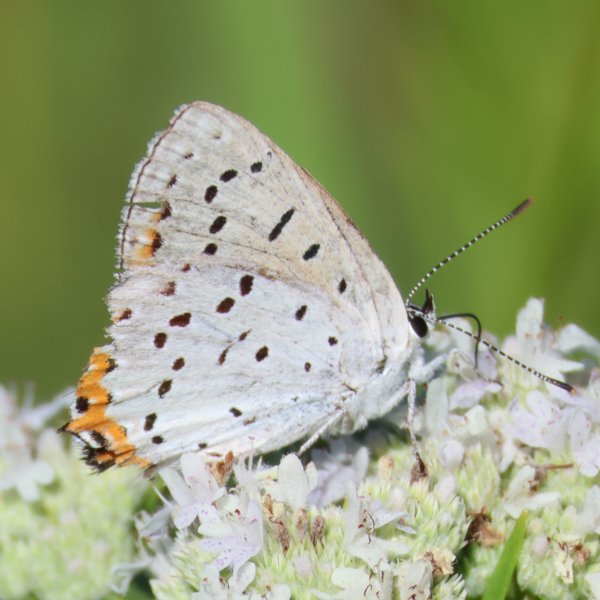
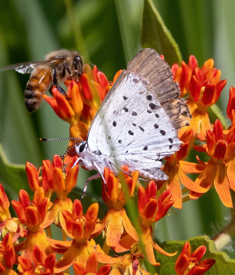
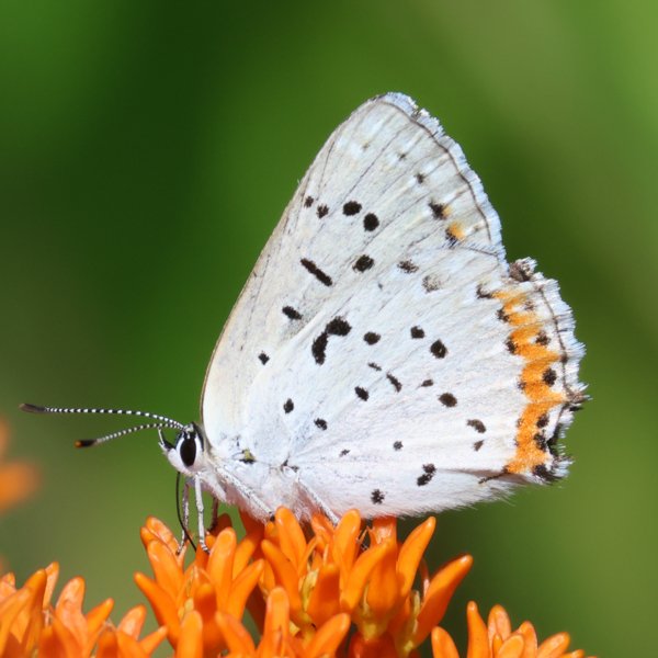
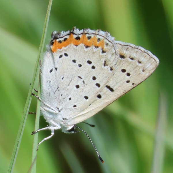
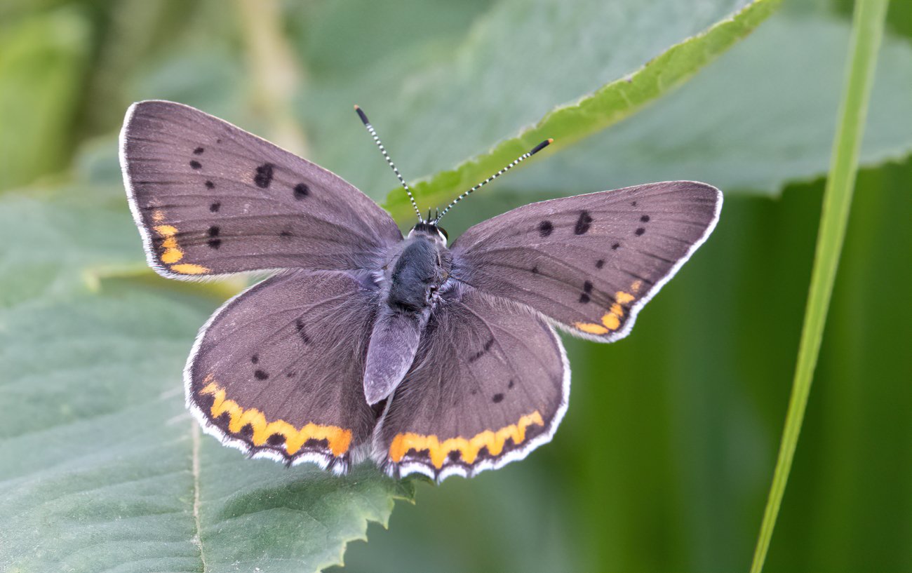
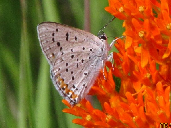
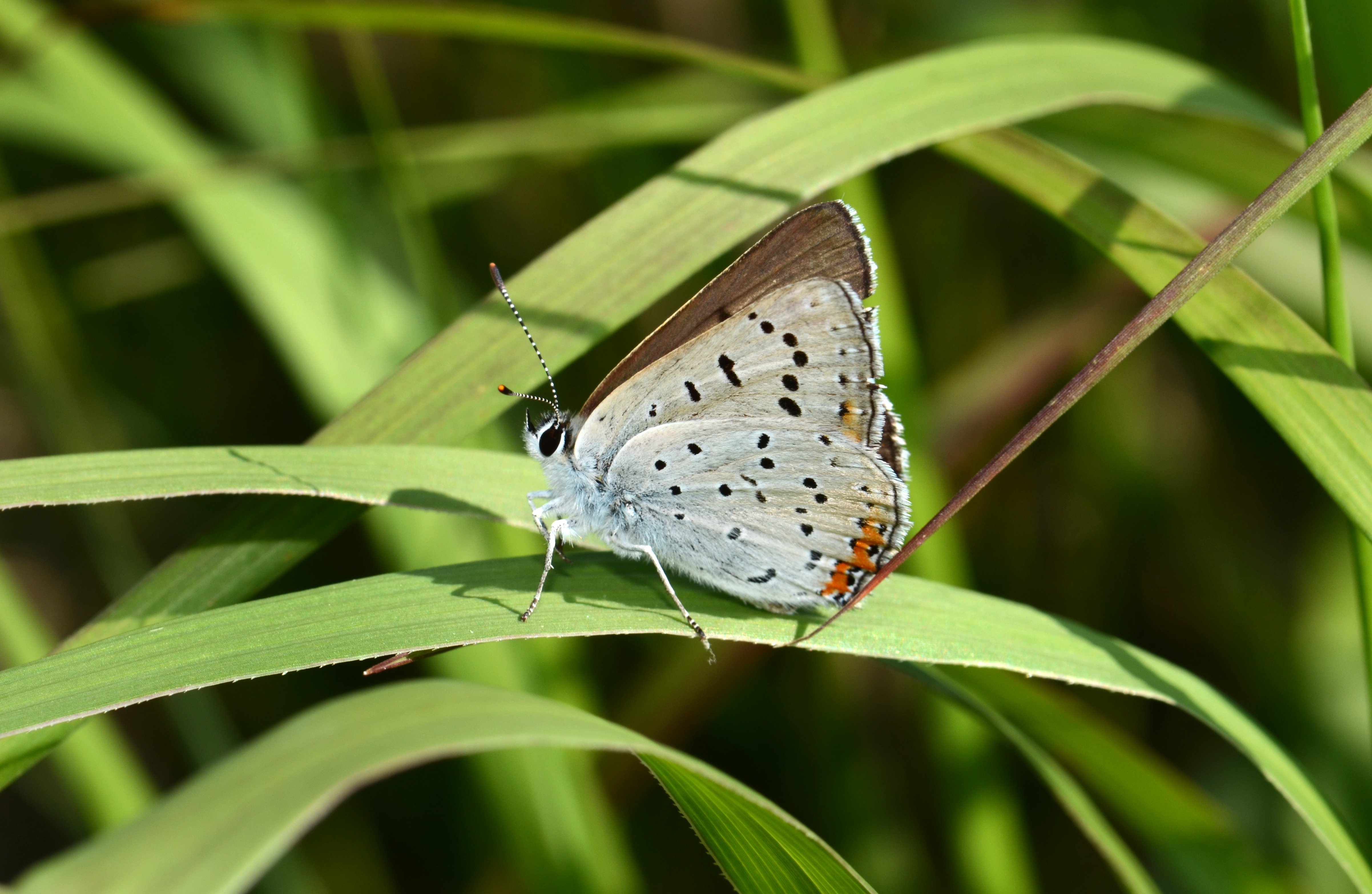
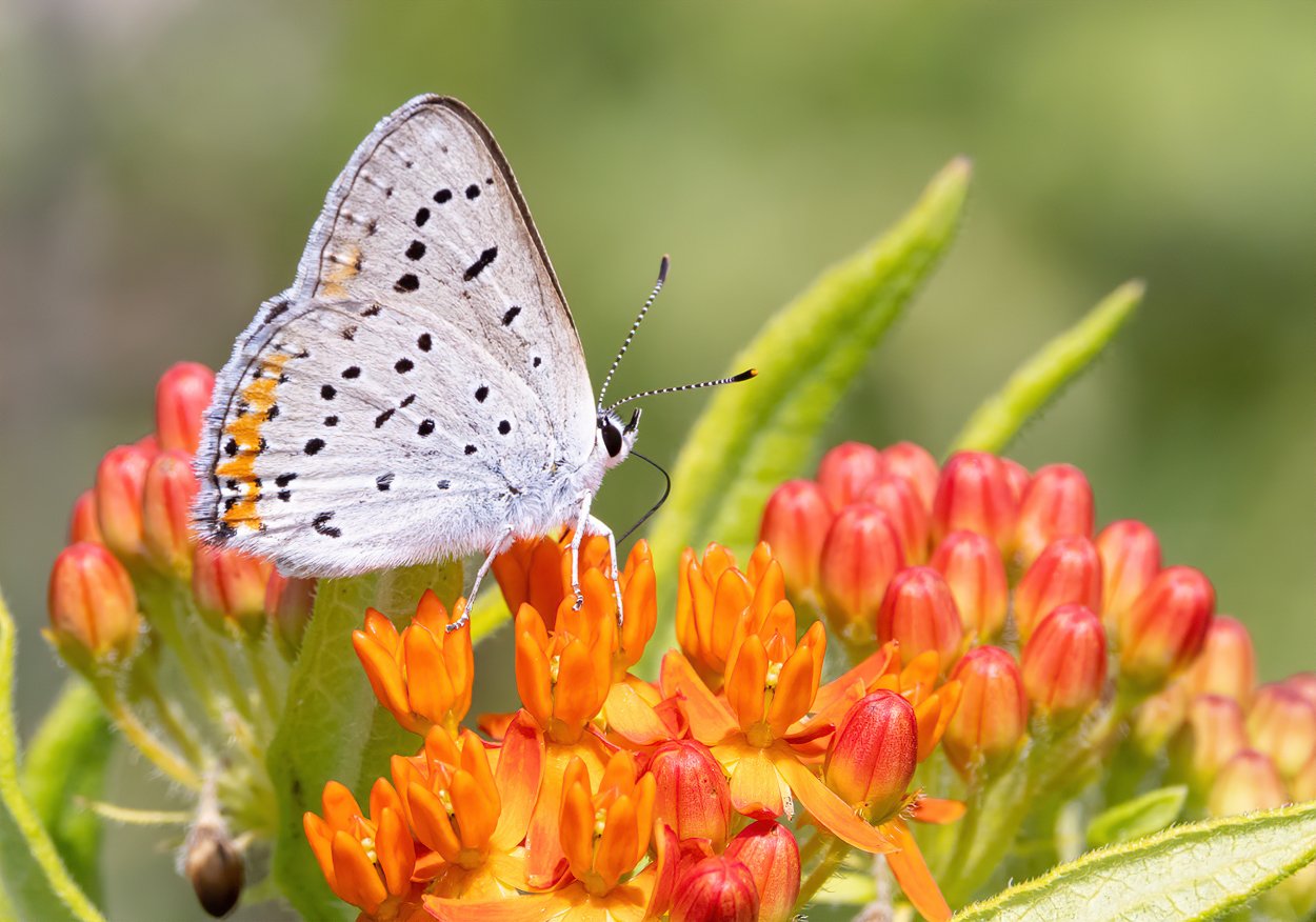
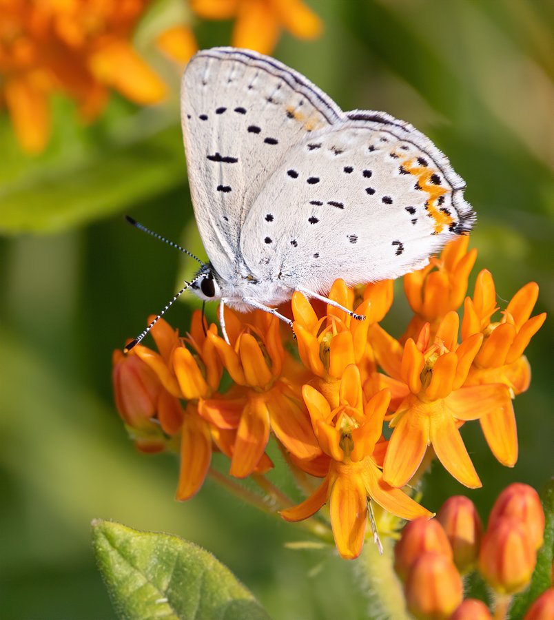
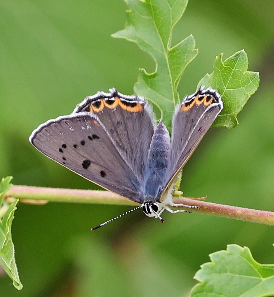
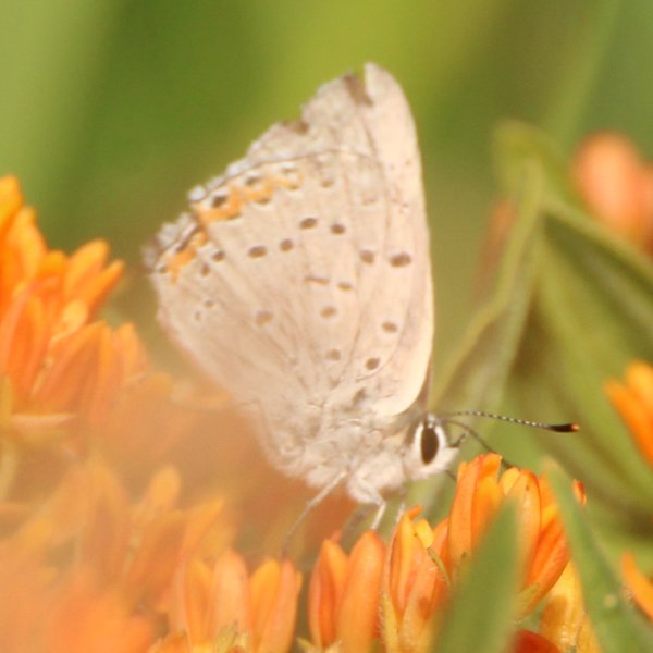
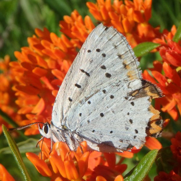
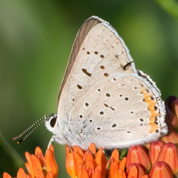
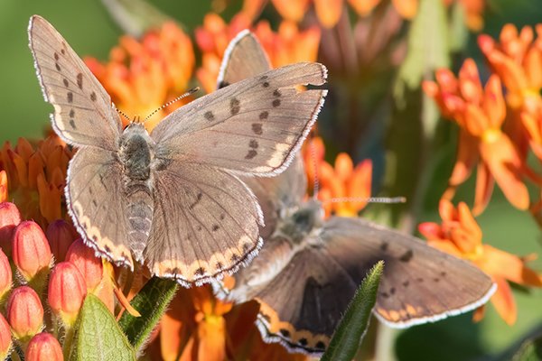
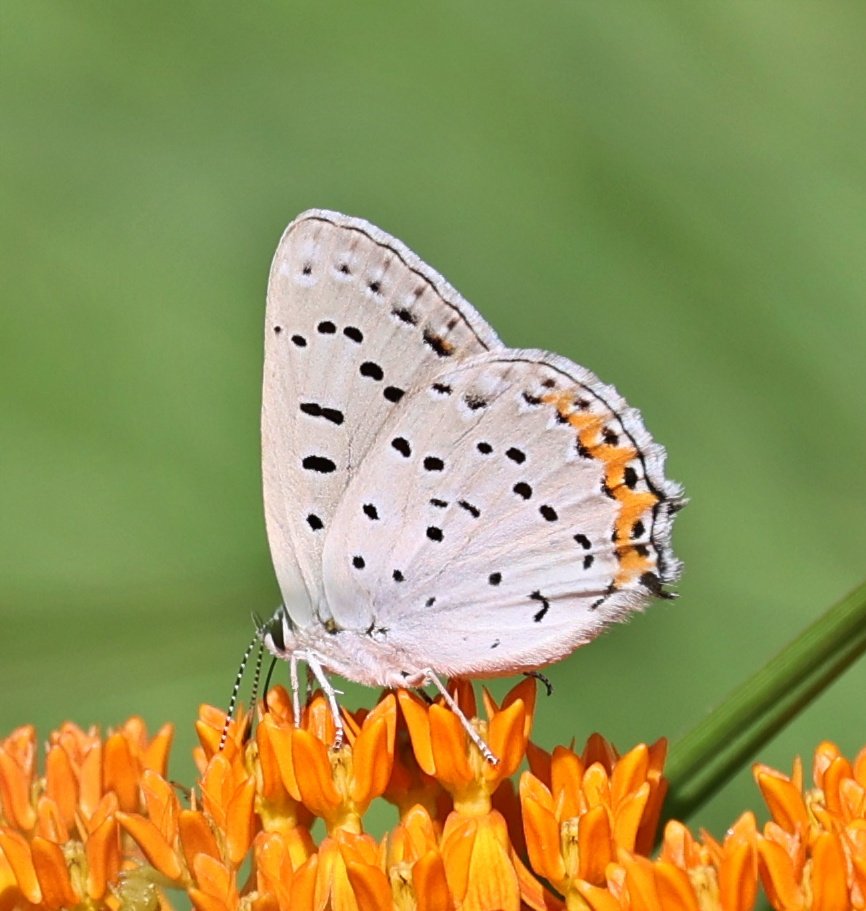
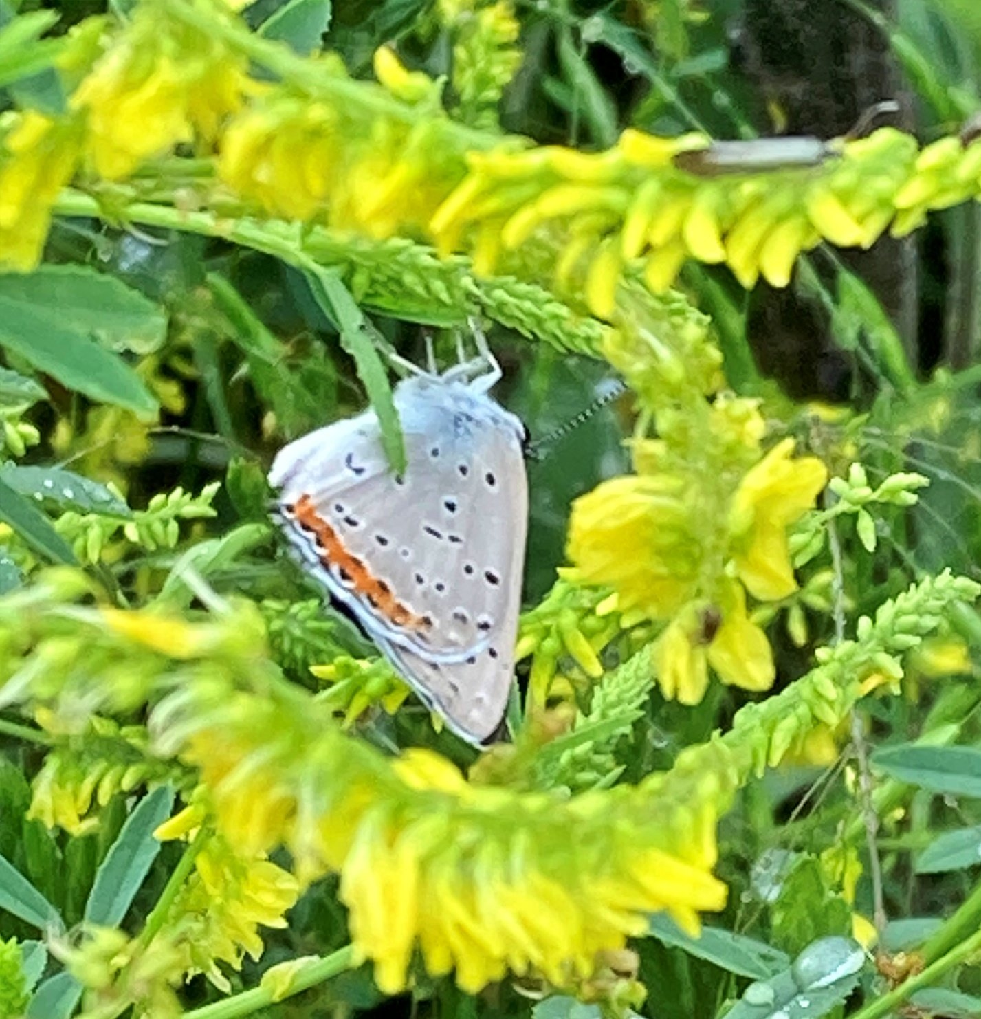
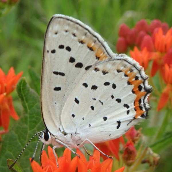
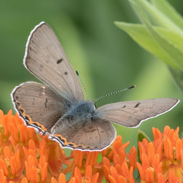
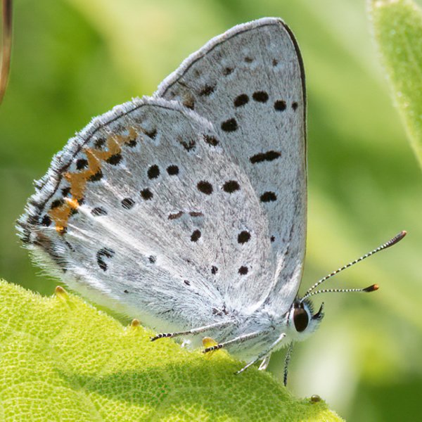
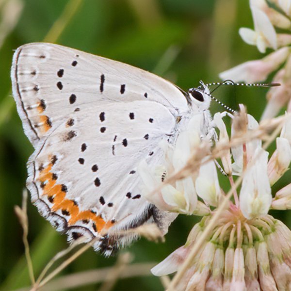
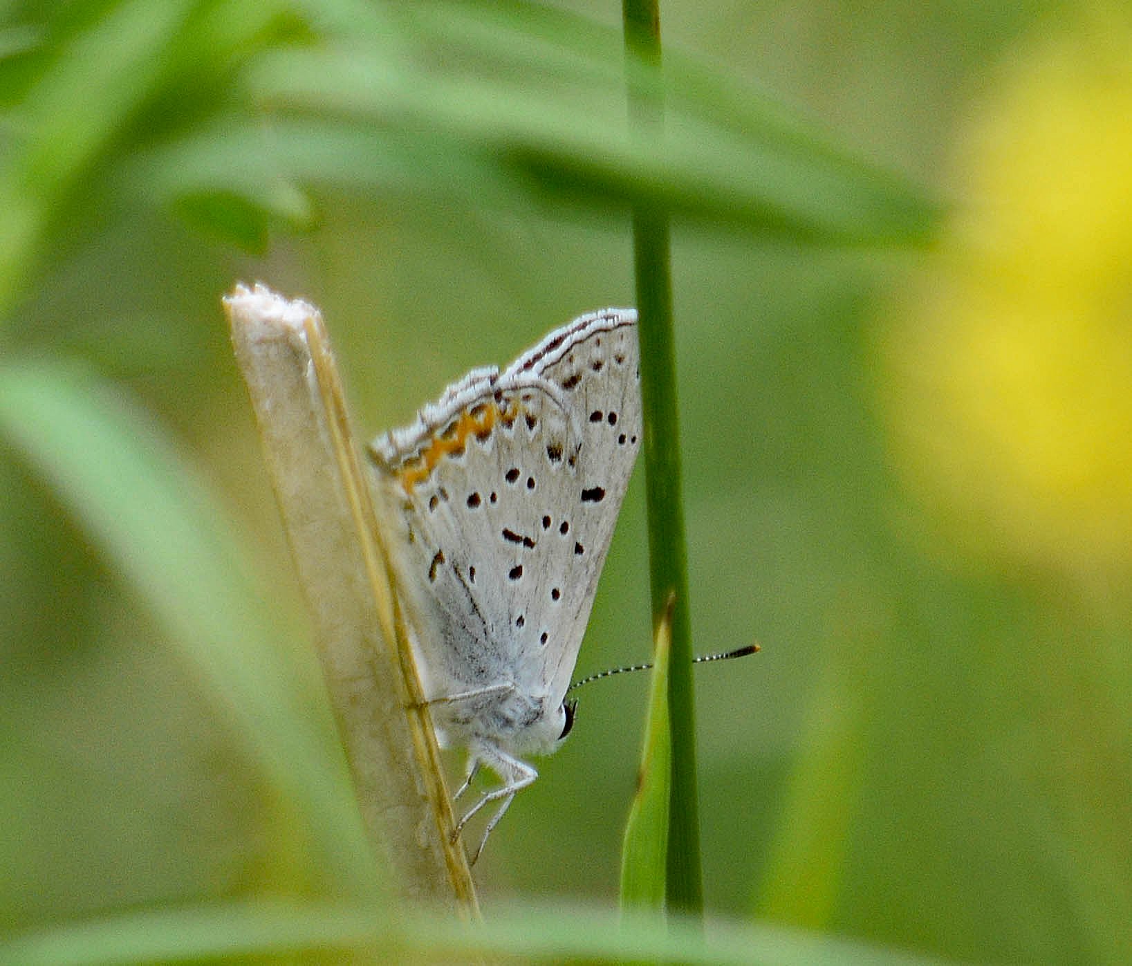
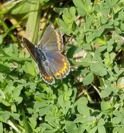
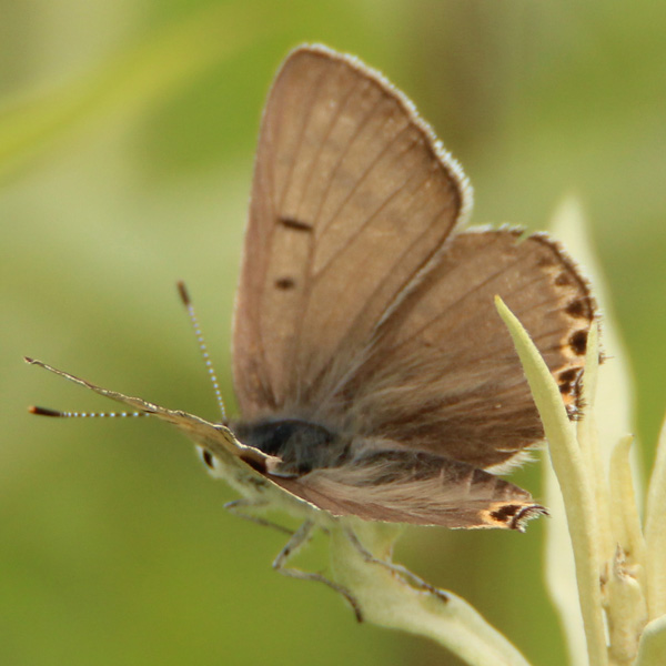
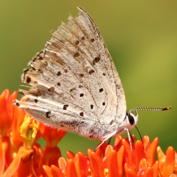
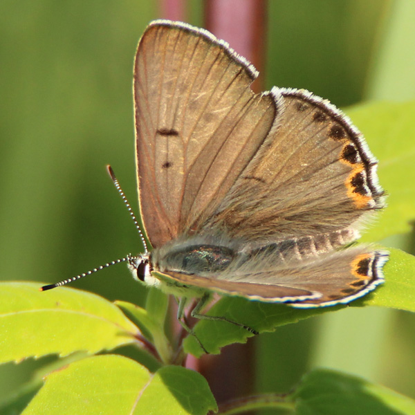
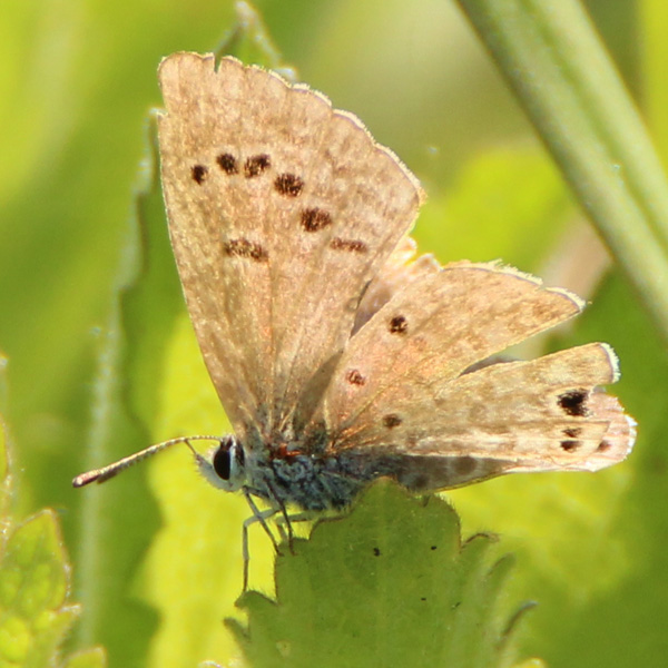
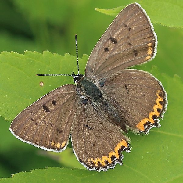
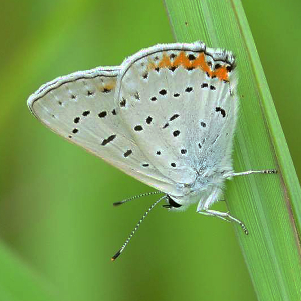
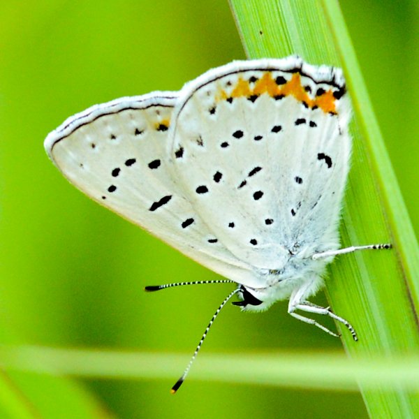
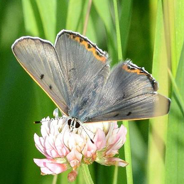
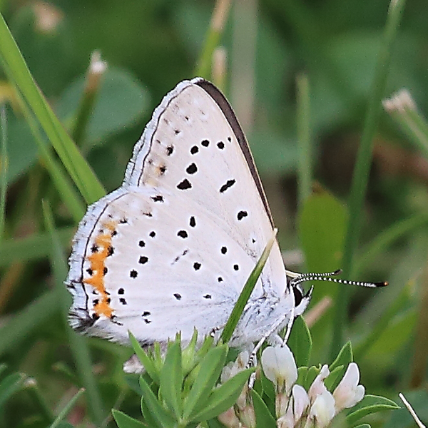
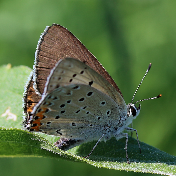
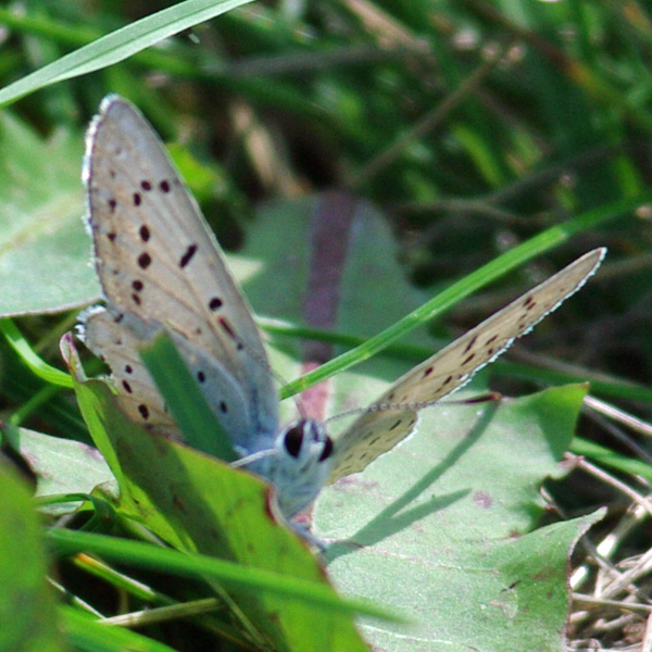
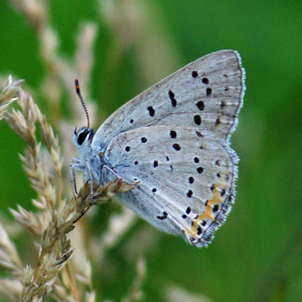
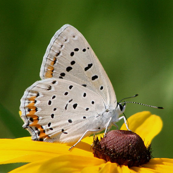
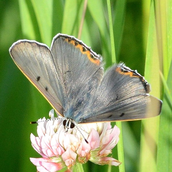
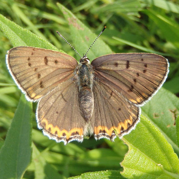
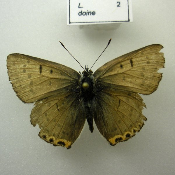
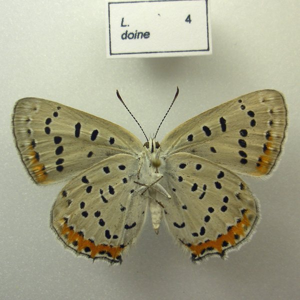
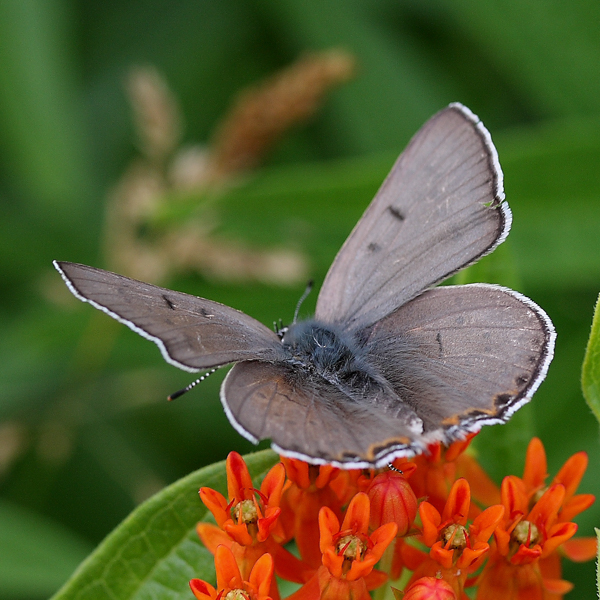
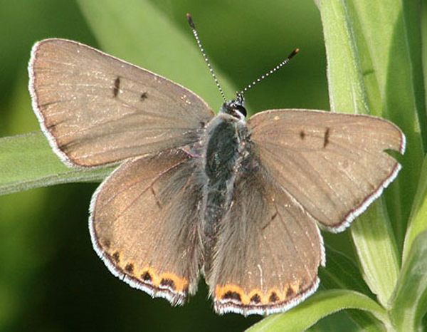
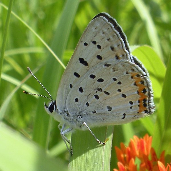
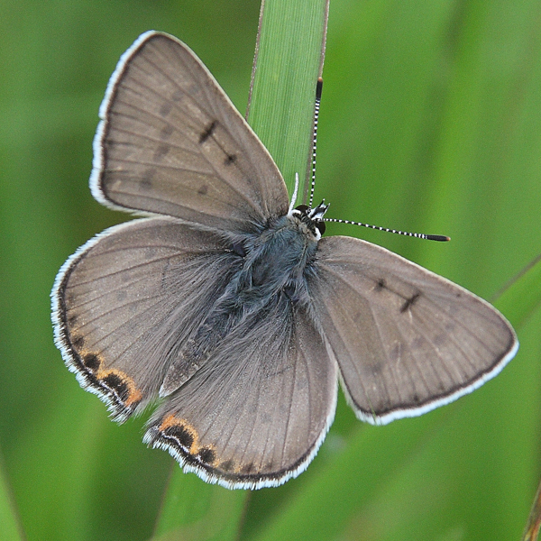
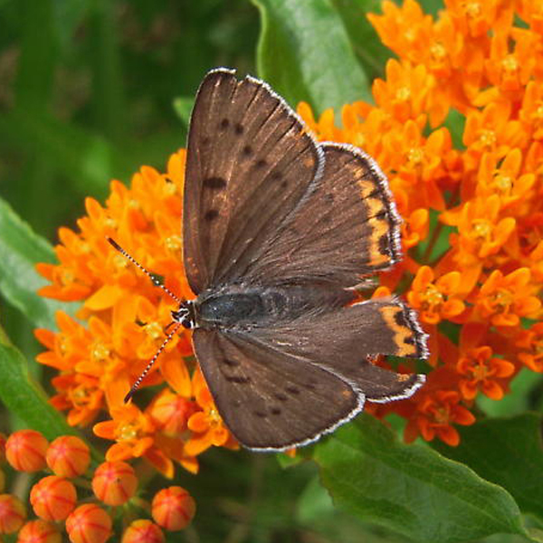
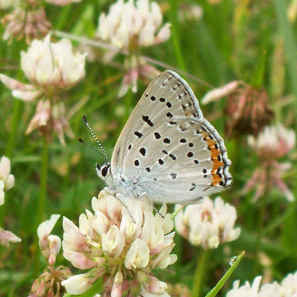
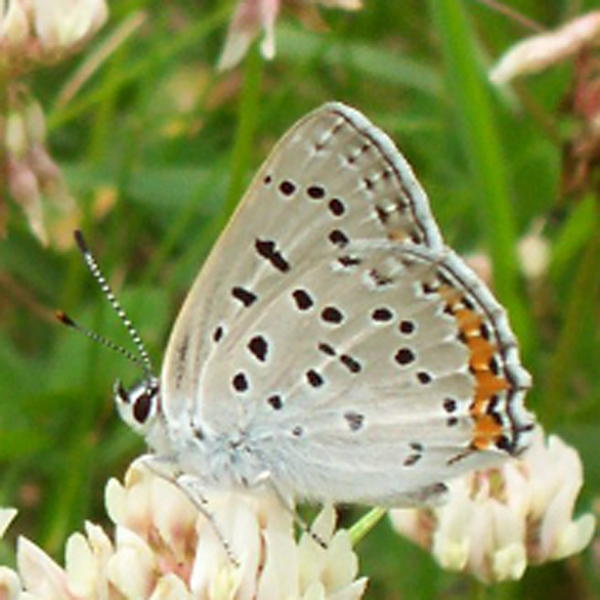
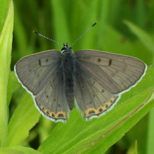
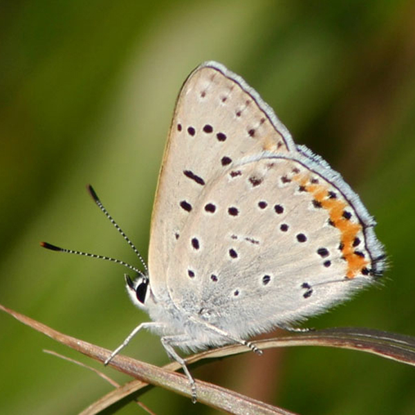
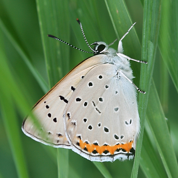
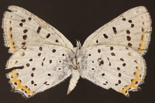
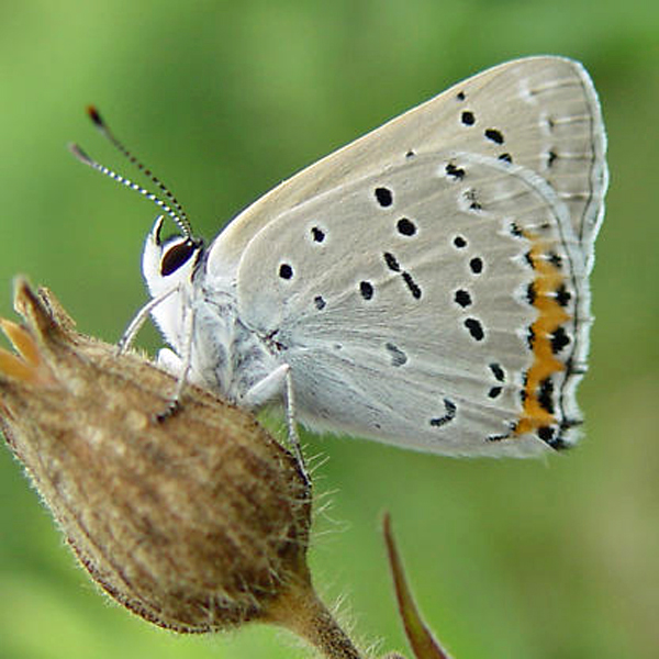
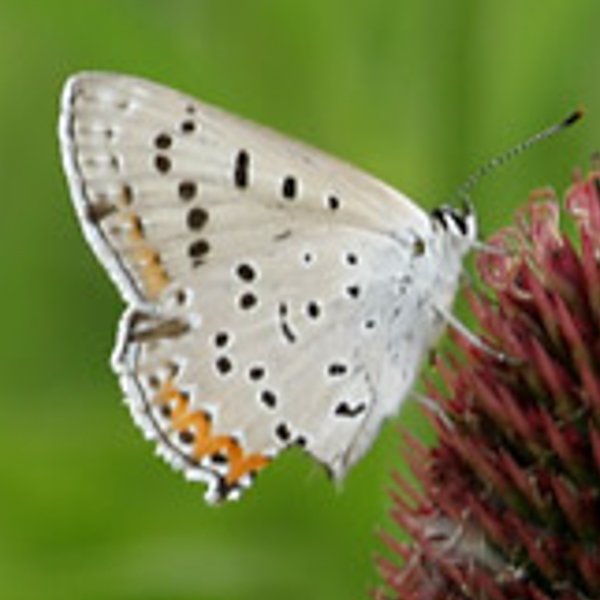
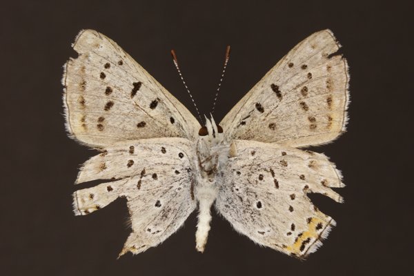
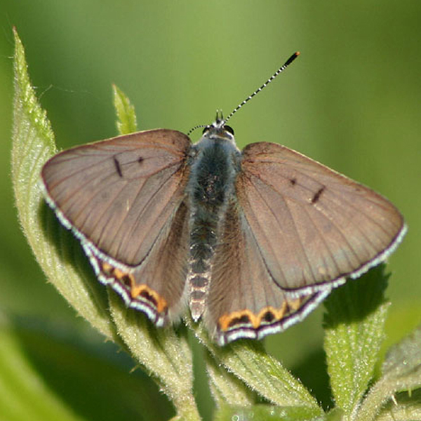
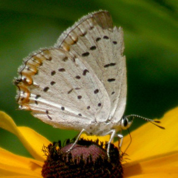
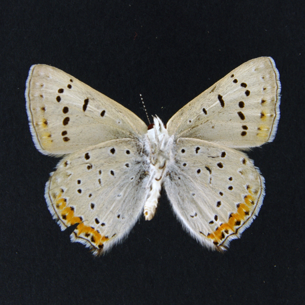
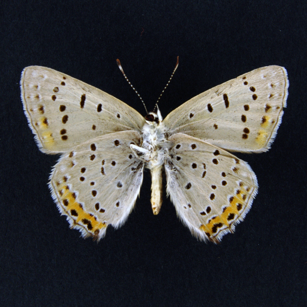
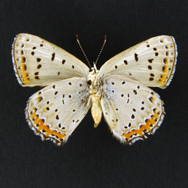
Distinguishing features: The male is gray above with several orange-bordered black spots on the hindwing margin. Below it is light gray to whitish with black spots and has an orange hindwing margin. The female is similar but as has black spots above.
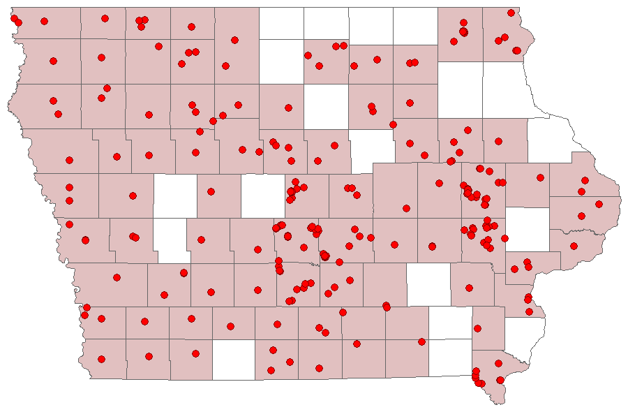
Distribution and habitat: It is common in the western half of Iowa but is more scattered in the east. Restricted to a variety of open, upland habitats such as native prairie, old fields, roadsides, open woods. In the east, is appears more frequent in sandy sites.
Natural History: Larvae consume dock (Rumex) species. In 1892, Willard sent Skinner some larvae, which had been collected in Grinnell from what was claimed to be yard dock (Rumex longifolius) an introduced species not known from the state. Likely the actual host plant was curled dock (Rumex crispus), which is an abundant Iowa weed.

| Record # | Date | Locale | State | Lat/Lon | Collected By | Count |
|---|---|---|---|---|---|---|
 367416 367416
|
2024-06-20 | Reif Reilly Fen and Prairie | Iowa | 41.829124 -91.488034 | Mark Madsen | 2 |
| 365912 | 2023-07-15 | Neal Smith National Wildlife Refuge | Iowa | 41.56153 -93.276552 | IBSN | 11 |
| 365913 | 2023-07-15 | Neal Smith National Wildlife Refuge | Iowa | 41.56153 -93.276552 | IBSN | 6 |
 337352 337352
|
2023-07-11 | F. W. Kent Park | Iowa | 41.73612 -91.734325 | Mark Madsen | 1 |
| 365909 | 2023-07-11 | Ada Hayden Heritage Park | Iowa | 42.06952 -93.638503 | IBSN | 1 |
| 365910 | 2023-07-11 | Ada Hayden Heritage Park | Iowa | 42.06952 -93.638503 | IBSN | 1 |
| 365911 | 2023-07-11 | Wanatee County Park | Iowa | 42.015055 -91.567104 | IBSN | 1 |
 343658 343658
|
2023-07-09 | MacBride Nature Recreation Area | Iowa | 41.78699205 -91.56850352 | Mark Brown | 1 |
 346341 346341
|
2023-07-09 | Annett Nature Center Park | Iowa | 41.298771 -93.576388 | Jay Gilliam | 12 |
| 365908 | 2023-07-09 | Chain Lakes County Park | Iowa | 42.059065 -91.763772 | IBSN | 1 |
| 362357 | 2023-07-08 | F. W. Kent Park | Iowa | 41.722202 -91.729031 | IBSN | 1 |
| 365904 | 2023-07-08 | Ada Hayden Heritage Park | Iowa | 42.06952 -93.638503 | IBSN | 3 |
| 365905 | 2023-07-08 | Ada Hayden Heritage Park | Iowa | 42.06952 -93.638503 | IBSN | 1 |
| 365906 | 2023-07-08 | Ada Hayden Heritage Park | Iowa | 42.06952 -93.638503 | IBSN | 4 |
| 365907 | 2023-07-08 | Chain Lakes County Park | Iowa | 42.059065 -91.763772 | IBSN | 7 |
| 362356 | 2023-07-06 | Indian Creek Nature Center | Iowa | 41.965586 -91.587857 | IBSN | 2 |
| 365901 | 2023-07-06 | Ada Hayden Heritage Park | Iowa | 42.06952 -93.638503 | IBSN | 3 |
| 365902 | 2023-07-06 | Ada Hayden Heritage Park | Iowa | 42.06952 -93.638503 | IBSN | 9 |
| 365903 | 2023-07-06 | Chain Lakes County Park | Iowa | 42.059065 -91.763772 | IBSN | 3 |
 343573 343573
|
2023-07-04 | Atherton Wetland | Iowa | 41.84551103 -91.56017102 | Mark Brown | 1 |
| 365900 | 2023-07-04 | Chain Lakes County Park | Iowa | 42.059065 -91.763772 | IBSN | 2 |
| 346766 | 2023-07-03 | Wolter's Prairie/Ely-Bauermeister Wildlife Management | Iowa | 43.416296 -95.604163 | Jay Gilliam | 1 |
| 362354 | 2023-07-03 | Jester Park | Iowa | 41.786753 -93.792568 | IBSN | 2 |
| 362355 | 2023-07-03 | Port Louisa National Wildlife Refuge | Iowa | 41.213749 -91.127713 | IBSN | 1 |
| 365898 | 2023-07-03 | Chain Lakes County Park | Iowa | 42.059065 -91.763772 | IBSN | 1 |
| 365899 | 2023-07-03 | Chain Lakes County Park | Iowa | 42.059065 -91.763772 | IBSN | 8 |
 343397 343397
|
2023-07-02 | Brushy Creek State Recreation Area | Iowa | 42.38334197 -93.97110478 | Mark Brown | 1 |
| 365895 | 2023-07-02 | Ada Hayden Heritage Park | Iowa | 42.06952 -93.638503 | IBSN | 10 |
| 365896 | 2023-07-02 | Ada Hayden Heritage Park | Iowa | 42.06952 -93.638503 | IBSN | 22 |
| 365897 | 2023-07-02 | Chain Lakes County Park | Iowa | 42.059065 -91.763772 | IBSN | 4 |
 346257 346257
|
2023-07-01 | O'Brien Prairie Preserve | Iowa | 42.676719 -96.099304 | Jay Gilliam | 8 |
| 365894 | 2023-07-01 | Chain Lakes County Park | Iowa | 42.059065 -91.763772 | IBSN | 3 |
| 365893 | 2023-06-30 | Chain Lakes County Park | Iowa | 42.059065 -91.763772 | IBSN | 5 |
| 362353 | 2023-06-27 | Central College Field Station | Iowa | 41.368123 -93.01636 | IBSN | 3 |
| 365888 | 2023-06-27 | Ada Hayden Heritage Park | Iowa | 42.06952 -93.638503 | IBSN | 8 |
| 365889 | 2023-06-27 | Ada Hayden Heritage Park | Iowa | 42.06952 -93.638503 | IBSN | 17 |
| 365890 | 2023-06-27 | Ada Hayden Heritage Park | Iowa | 42.072403 -93.62696 | IBSN | 1 |
| 365891 | 2023-06-27 | Ada Hayden Heritage Park | Iowa | 42.072403 -93.62696 | IBSN | 2 |
| 365892 | 2023-06-27 | Ada Hayden Heritage Park | Iowa | 42.072403 -93.62696 | IBSN | 1 |
| 362351 | 2023-06-26 | Jester Park | Iowa | 41.786753 -93.792568 | IBSN | 8 |
| 362352 | 2023-06-26 | Jester Park | Iowa | 41.786753 -93.792568 | IBSN | 2 |
| 346616 | 2023-06-24 | Eldon Wildlife Management Area | Iowa | 40.880576 -92.25189 | Jay Gilliam | 1 |
 344127 344127
|
2023-06-22 | Prairiewoods Franciscan Spirituality Center | Iowa | 42.048527 -91.67118 | Frank Olsen | 4 |
 335114 335114
|
2023-06-19 | Black Hawk Mitigation | Iowa | 42.354596 -92.225466 | Kenneth Heiar | 1 |
 346225 346225
|
2023-06-18 | Sheeder Prairie State Preserve | Iowa | 41.689477 -94.587704 | Jay Gilliam | 8 |
| 365885 | 2023-06-18 | Ada Hayden Heritage Park | Iowa | 42.06952 -93.638503 | IBSN | 10 |
| 365886 | 2023-06-18 | Ada Hayden Heritage Park | Iowa | 42.06952 -93.638503 | IBSN | 1 |
| 365887 | 2023-06-18 | Ada Hayden Heritage Park | Iowa | 42.06952 -93.638503 | IBSN | 22 |
| 346546 | 2023-06-17 | Eddyville Cemetery Wetland | Iowa | 41.167726 -92.631735 | Jay Gilliam | 1 |
| 346552 | 2023-06-17 | Eddyville Sand Prairie Park | Iowa | 41.154568 -92.618726 | Jay Gilliam | 4 |
| 346567 | 2023-06-17 | Slip Bluff County Park | Iowa | 40.652884 -93.847544 | Jay Gilliam | 3 |
| 365883 | 2023-06-17 | Jester Park | Iowa | 41.786753 -93.792568 | IBSN | 4 |
| 365884 | 2023-06-17 | Jester Park | Iowa | 41.786753 -93.792568 | IBSN | 3 |
 346213 346213
|
2023-06-16 | Annett Nature Center Park | Iowa | 41.298771 -93.576388 | Jay Gilliam | 9 |
| 365880 | 2023-06-16 | Ada Hayden Heritage Park | Iowa | 42.06952 -93.638503 | IBSN | 11 |
| 365881 | 2023-06-16 | Ada Hayden Heritage Park | Iowa | 42.06952 -93.638503 | IBSN | 10 |
| 365882 | 2023-06-16 | Ada Hayden Heritage Park | Iowa | 42.072403 -93.62696 | IBSN | 2 |
| 346508 | 2023-06-14 | Chichaqua Bottoms- Clingan Grassland Unit | Iowa | 41.777616 -93.355846 | Jay Gilliam | 2 |
| 362350 | 2023-06-14 | Port Louisa National Wildlife Refuge | Iowa | 41.213749 -91.127713 | IBSN | 1 |
 334866 334866
|
2023-06-12 | Terry Trueblood Recreation Area | Iowa | 41.62681 -91.531769 | Mark Madsen | 1 |
| 362349 | 2023-06-12 | Willow Creek/Kiwanis Park | Iowa | 41.645031 -91.569005 | IBSN | 1 |
| 365879 | 2023-06-10 | Ada Hayden Heritage Park | Iowa | 42.06952 -93.638503 | IBSN | 2 |
| 365878 | 2023-06-09 | F. W. Kent Park | Iowa | 41.722202 -91.729031 | IBSN | 3 |
| 362348 | 2023-06-04 | Wickiup Hill Outdoor Learning Area | Iowa | 42.08511 -91.766321 | IBSN | 1 |
| 365877 | 2023-05-31 | Chichaqua Bottoms Greenbelt | Iowa | 41.797918 -93.411201 | IBSN | 1 |
| 328812 | 2022-07-12 | Wanatee County Park | Iowa | 42.013008 -91.56718 | IBSN | 2 |
| 328810 | 2022-07-07 | Jester Park | Iowa | 41.786297 -93.788656 | IBSN | 5 |
 319606 319606
|
2022-07-04 | Brushy Creek State Recreation Area | Iowa | 42.38341461 -93.97091702 | Mark Brown | 1 |
| 318170 | 2022-07-03 | Slip Bluff County Park | Iowa | 40.652884 -93.847544 | Jay Gilliam | 1 |
 316401 316401
|
2022-07-02 | Atherton Wetland | Iowa | 41.84575612 -91.55764531 | Mark Brown | 1 |
| 328807 | 2022-07-02 | Ada Hayden Heritage Park | Iowa | 42.0638 -93.636305 | IBSN | 12 |
| 328809 | 2022-07-01 | Jester Park | Iowa | 41.786297 -93.788656 | IBSN | 8 |
| 328806 | 2022-06-28 | Ada Hayden Heritage Park | Iowa | 42.0638 -93.636305 | IBSN | 9 |
| 328811 | 2022-06-27 | Neal Smith National Wildlife Refuge | Iowa | 41.558683 -93.280422 | IBSN | 7 |
| 316949 | 2022-06-26 | Prairiewoods Franciscan Spirituality Center | Iowa | 42.048527 -91.67118 | Frank Olsen | 6 |
 318065 318065
|
2022-06-26 | Rolling Thunder Prairie State Preserve | Iowa | 41.204306 -93.656457 | Jay Gilliam | 2 |
 318079 318079
|
2022-06-26 | Annett Nature Center Park | Iowa | 41.298771 -93.576388 | Jay Gilliam | 11 |
| 349686 | 2022-06-26 | Corriell Nature Preserve | Iowa | 41.520093 -91.159406 | Chris Edwards | 1 |
| 328805 | 2022-06-24 | Ada Hayden Heritage Park | Iowa | 42.0638 -93.636305 | IBSN | 29 |
| 328808 | 2022-06-23 | Jester Park | Iowa | 41.786297 -93.788656 | IBSN | 11 |
| 328804 | 2022-06-22 | Ada Hayden Heritage Park | Iowa | 42.0638 -93.636305 | IBSN | 15 |
 310649 310649
|
2022-06-21 | Red Cedar Wildlife Area | Iowa | 41.457133 -91.269377 | Mark Madsen | 4 |
| 328803 | 2022-06-19 | Ada Hayden Heritage Park | Iowa | 42.0638 -93.636305 | IBSN | 3 |
 310014 310014
|
2022-06-12 | Terry Trueblood Recreation Area | Iowa | 41.627199 -91.530828 | Mark Madsen | 1 |
| 304848 | 2021-08-08 | Big Creek State Park | Iowa | 41.804681 -93.733121 | IBSN | 1 |
| 304850 | 2021-07-20 | Ada Hayden Heritage Park | Iowa | 42.066757 -93.635499 | IBSN | 1 |
| 304846 | 2021-07-16 | Big Creek State Park | Iowa | 41.804681 -93.733121 | IBSN | 1 |
| 304832 | 2021-07-03 | Decorah Community Prairie | Iowa | 43.300937 -91.803306 | IBSN | 1 |
| 304837 | 2021-07-03 | Ada Hayden Heritage Park | Iowa | 42.066757 -93.635499 | IBSN | 2 |
| 308127 | 2021-07-02 | Atherton Wetland | Iowa | 41.847407 -91.560504 | Chris Edwards | 3 |
| 297326 | 2021-07-01 | Hitaga Sand Ridge Prairie Preserve | Iowa | 42.25052 -91.63543 | Frank Olsen | 14 |
| 304843 | 2021-07-01 | Red Feather Prairie | Iowa | 41.7205866 -93.669776 | IBSN | 2 |
 296317 296317
|
2021-06-29 | Atherton Wetland | Iowa | 41.847145 -91.559899 | Mark Brown | 1 |
 299772 299772
|
2021-06-27 | Corner prairie- 300th St & Raven Ave | Iowa | 43.198927 -93.161782 | Jay Gilliam | 3 |
| 300640 | 2021-06-27 | Corner prairie- 300th St & Raven Ave | Iowa | 43.198927 -93.161782 | Jay Gilliam | 3 |
| 300651 | 2021-06-27 | Wilkinson County Park | Iowa | 43.203277 -93.080456 | Jay Gilliam | 1 |
| 304830 | 2021-06-27 | Ada Hayden Heritage Park | Iowa | 42.066757 -93.635499 | IBSN | 2 |
| 304834 | 2021-06-27 | Neal Smith National Wildlife Refuge | Iowa | 41.559984 -93.279044 | IBSN | 5 |
| 304835 | 2021-06-27 | Bank Swallow Bend Wildlife Area | Iowa | 41.341342 -93.486167 | IBSN | 1 |
| 304847 | 2021-06-27 | Central College Field Station | Iowa | 41.368123 -93.01636 | IBSN | 1 |
| 297552 | 2021-06-24 | Prairiewoods Franciscan Spirituality Center | Iowa | 42.048527 -91.67118 | Frank Olsen | 2 |
| 304840 | 2021-06-23 | Ada Hayden Heritage Park | Iowa | 42.066757 -93.635499 | IBSN | 10 |
| 304841 | 2021-06-23 | Red Feather Prairie | Iowa | 41.7205866 -93.669776 | IBSN | 2 |
| 304851 | 2021-06-20 | Ada Hayden Heritage Park | Iowa | 42.066757 -93.635499 | IBSN | 3 |
| 300601 | 2021-06-19 | Wilkinson County Park | Iowa | 43.203277 -93.080456 | Jay Gilliam | 1 |
| 304842 | 2021-06-19 | Ada Hayden Heritage Park | Iowa | 42.066757 -93.635499 | IBSN | 6 |
| 300573 | 2021-06-18 | Rolling Thunder Prairie State Preserve | Iowa | 41.204306 -93.656457 | Jay Gilliam | 1 |
| 304838 | 2021-06-18 | Ada Hayden Heritage Park | Iowa | 42.066757 -93.635499 | IBSN | 4 |
| 304849 | 2021-06-16 | Ada Hayden Heritage Park | Iowa | 42.066757 -93.635499 | IBSN | 8 |
| 304833 | 2021-06-15 | Ada Hayden Heritage Park | Iowa | 42.066757 -93.635499 | IBSN | 8 |
| 304839 | 2021-06-15 | Red Feather Prairie | Iowa | 41.7205866 -93.669776 | IBSN | 2 |
| 297546 | 2021-06-14 | Prairiewoods Franciscan Spirituality Center | Iowa | 42.048527 -91.67118 | Frank Olsen | 8 |
| 297533 | 2021-06-13 | Prairiewoods Franciscan Spirituality Center | Iowa | 42.048527 -91.67118 | Frank Olsen | 4 |
| 304845 | 2021-06-13 | Ada Hayden Heritage Park | Iowa | 42.066757 -93.635499 | IBSN | 3 |
| 304829 | 2021-06-12 | Ada Hayden Heritage Park | Iowa | 42.066757 -93.635499 | IBSN | 2 |
| 304844 | 2021-06-12 | Ada Hayden Heritage Park | Iowa | 42.066757 -93.635499 | IBSN | 6 |
| 304836 | 2021-06-09 | Neal Smith National Wildlife Refuge | Iowa | 41.559984 -93.279044 | IBSN | 1 |
| 304831 | 2021-05-26 | Red Feather Prairie | Iowa | 41.7205866 -93.669776 | IBSN | 2 |
| 284748 | 2020-07-22 | Red Feather Prairie | Iowa | 41.723712 -93.671758 | IBSN | 4 |
| 273383 | 2020-07-05 | Hitaga Sand Ridge Prairie Preserve | Iowa | 42.25088 -91.632179 | Frank Olsen | 1 |
 275912 275912
|
2020-07-02 | Wilkinson County Park | Iowa | 43.203277 -93.080456 | Jay Gilliam | 1 |
| 284747 | 2020-06-29 | Indian Creek Nature Center | Iowa | 41.966565 -91.588255 | IBSN | 1 |
| 274535 | 2020-06-28 | Wickiup Hill Outdoor Learning Area | Iowa | 42.08398 -91.7651 | Frank Olsen | 2 |
| 284746 | 2020-06-28 | Ada Hayden Heritage Park | Iowa | 42.067913 -93.629339 | IBSN | 1 |
| 281273 | 2020-06-27 | Hawkeye Willdlife Management Area | Iowa | 41.775104 -91.705532 | Chris Edwards | 3 |
| 284745 | 2020-06-27 | Neal Smith National Wildlife Refuge | Iowa | 41.558756 -93.279723 | IBSN | 5 |
 275819 275819
|
2020-06-26 | Chichaqua Bottoms Sandhill Prairie | Iowa | 41.775593 -93.379902 | Jay Gilliam | 1 |
 267368 267368
|
2020-06-25 | Mann Property | Iowa | 42.10025144 -92.9931302 | Jim Durbin | 4 |
 267371 267371
|
2020-06-25 | Mann Property | Iowa | 42.10025144 -92.9931302 | Jim Durbin | 1 |
 275796 275796
|
2020-06-24 | Wilkinson County Park | Iowa | 43.203277 -93.080456 | Jay Gilliam | 1 |
| 284744 | 2020-06-24 | Red Feather Prairie | Iowa | 41.723712 -93.671758 | IBSN | 8 |
| 355541 | 2020-06-24 | Spilde Woods | Iowa | 43.317783 -91.812417 | Kayla Gibson | 1 |
| 284741 | 2020-06-23 | Ada Hayden Heritage Park | Iowa | 42.067913 -93.629339 | IBSN | 4 |
| 284742 | 2020-06-23 | Indian Creek Nature Center | Iowa | 41.966565 -91.588255 | IBSN | 1 |
| 284743 | 2020-06-23 | Port Louisa National Wildlife Refuge, Horseshoe Bend | Iowa | 41.120156 -91.116069 | IBSN | 1 |
| 284740 | 2020-06-19 | Lake Anita State Park | Iowa | 41.431019 -94.772716 | IBSN | 1 |
 266871 266871
|
2020-06-18 | Purple Martin Lake, Water Resource Area | Iowa | 41.526441 -93.76693 | Barb Manning | 1 |
| 281272 | 2020-06-12 | Stephens State Forest - Thousand Acre Unit, Monroe County | Iowa | 41.116878 -93.084844 | Chris Edwards | 1 |
| 284739 | 2020-06-12 | Red Feather Prairie | Iowa | 41.723712 -93.671758 | IBSN | 2 |
| 257376 | 2019-09-04 | Port Louisa National Wildlife Refuge, Horseshoe Bend | Iowa | 41.119631 -91.115408 | IBSN | 2 |
| 257384 | 2019-07-29 | Willow Creek/Kiwanis Park | Iowa | 41.648576 -91.569167 | IBSN | 2 |
 235099 235099
|
2019-07-24 | Red Feather Prairie | Iowa | 41.71468794 -93.67181044 | Chuck Hall | 1 |
| 257383 | 2019-07-24 | Red Feather Prairie | Iowa | 41.723743 -93.671574 | IBSN | 1 |
| 248885 | 2019-07-22 | F. W. Kent Park | Iowa | 41.72916 -91.727161 | Chris Edwards | 1 |
| 257373 | 2019-07-14 | Neal Smith National Wildlife Refuge | Iowa | 41.56153 -93.276552 | IBSN | 4 |
 233905 233905
|
2019-07-13 | Yellow River State Forest | Iowa | 43.1676 -91.254 | Mark Brown | 1 |
| 248826 | 2019-07-13 | Yellow River State Forest | Iowa | 43.170603 -91.240395 | Chris Edwards | 2 |
| 257360 | 2019-07-10 | Ada Hayden Heritage Park | Iowa | 42.073674 -93.634375 | IBSN | 1 |
| 240605 | 2019-07-08 | Prairiewoods Franciscan Spirituality Center | Iowa | 42.048527 -91.67118 | Frank Olsen | 1 |
 233706 233706
|
2019-07-07 | Eddyville Sand Prairie Park | Iowa | 41.153999 -92.6201 | Mark Brown | 1 |
| 240574 | 2019-07-06 | Hamilton and Tapken Prairie Preserve | Iowa | 42.1775 -90.9975 | Frank Olsen | 2 |
 233886 233886
|
2019-07-04 | Matsell Bridge Natural Area | Iowa | 42.14 -91.3983333 | Mark Brown | 1 |
| 240530 | 2019-07-01 | Prairiewoods Franciscan Spirituality Center | Iowa | 42.048527 -91.67118 | Frank Olsen | 1 |
| 240505 | 2019-06-29 | Wickiup Hill Outdoor Learning Area | Iowa | 42.08398 -91.7651 | Frank Olsen | 5 |
| 257359 | 2019-06-26 | Ada Hayden Heritage Park | Iowa | 42.073674 -93.634375 | IBSN | 2 |
| 257358 | 2019-06-25 | Ada Hayden Heritage Park | Iowa | 42.073674 -93.634375 | IBSN | 2 |
| 257357 | 2019-06-23 | Ada Hayden Heritage Park | Iowa | 42.073674 -93.634375 | IBSN | 2 |
| 257356 | 2019-06-20 | Ada Hayden Heritage Park | Iowa | 42.073674 -93.634375 | IBSN | 1 |
| 257370 | 2019-06-17 | Lake Anita State Park | Iowa | 41.423158 -94.772833 | IBSN | 1 |
| 257369 | 2019-06-10 | Lake Anita State Park | Iowa | 41.423158 -94.772833 | IBSN | 1 |
 233723 233723
|
2019-06-02 | Hawkeye Willdlife Management Area | Iowa | 41.784462 -91.713516 | Mark Brown | 1 |
| 257382 | 2018-07-09 | Red Feather Prairie | Iowa | 41.723743 -93.671574 | IBSN | 4 |
| 228709 | 2018-07-07 | Yellow River State Forest | Iowa | 43.170603 -91.240395 | Chris Edwards | 5 |
| 257381 | 2018-07-02 | Red Feather Prairie | Iowa | 41.723743 -93.671574 | IBSN | 13 |
 229303 229303
|
2018-06-28 | Ada Hayden Heritage Park | Iowa | 42.06694 -93.62944 | Wolfgang Oesterreich | 1 |
| 223501 | 2018-06-27 | Rowley Fen | Iowa | 42.37694 -91.85194 | Frank Olsen | 12 |
| 257355 | 2018-06-27 | Ada Hayden Heritage Park | Iowa | 42.073674 -93.634375 | IBSN | 1 |
| 223476 | 2018-06-24 | Rock Island Botanical State Preserve | Iowa | 42.025805 -91.72638 | Frank Olsen | 1 |
| 257353 | 2018-06-13 | Ada Hayden Heritage Park | Iowa | 42.073674 -93.634375 | IBSN | 1 |
| 257354 | 2018-06-12 | Ada Hayden Heritage Park | Iowa | 42.073674 -93.634375 | IBSN | 1 |
 212241 212241
|
2018-06-11 | Port Louisa National Wildlife Refuge | Iowa | 41.213788 -91.128845 | Mike Klag | 1 |
 212595 212595
|
2018-06-11 | Chain Lakes County Park | Iowa | 42.05498 -91.77115 | Don Ohde | 1 |
 247535 247535
|
2018-06-11 | Chain Lakes County Park | Iowa | 42.059065 -91.763772 | Don Ohde | 1 |
| 257366 | 2018-06-11 | Chain Lakes County Park | Iowa | 42.059065 -91.763772 | IBSN | 1 |
| 257363 | 2017-08-01 | Ada Hayden Heritage Park | Iowa | 42.068025 -93.627277 | IBSN | 2 |
| 257352 | 2017-07-13 | Ada Hayden Heritage Park | Iowa | 42.073674 -93.634375 | IBSN | 1 |
| 202951 | 2017-07-08 | Yellow River State Forest | Iowa | 43.170603 -91.240395 | Chris Edwards | 1 |
| 257380 | 2017-07-07 | Red Feather Prairie | Iowa | 41.723743 -93.671574 | IBSN | 1 |
| 257362 | 2017-07-05 | Ada Hayden Heritage Park | Iowa | 42.068025 -93.627277 | IBSN | 1 |
| 257351 | 2017-07-04 | Ada Hayden Heritage Park | Iowa | 42.073674 -93.634375 | IBSN | 1 |
| 257350 | 2017-06-30 | Ada Hayden Heritage Park | Iowa | 42.073674 -93.634375 | IBSN | 1 |
| 257349 | 2017-06-27 | Ada Hayden Heritage Park | Iowa | 42.073674 -93.634375 | IBSN | 1 |
| 257348 | 2017-06-26 | Ada Hayden Heritage Park | Iowa | 42.073674 -93.634375 | IBSN | 1 |
| 257372 | 2017-06-21 | Neal Smith National Wildlife Refuge | Iowa | 41.56153 -93.276552 | IBSN | 4 |
| 257346 | 2017-06-20 | Ada Hayden Heritage Park | Iowa | 42.073674 -93.634375 | IBSN | 3 |
| 257361 | 2017-06-19 | Ada Hayden Heritage Park | Iowa | 42.068025 -93.627277 | IBSN | 3 |
 201879 201879
|
2017-06-16 | Wickiup Hill Outdoor Learning Area | Iowa | 42.0827778 -91.7638889 | Don Ohde | 1 |
 229263 229263
|
2017-06-16 | Ada Hayden Heritage Park | Iowa | 42.06694 -93.62944 | Wolfgang Oesterreich | 1 |
 229264 229264
|
2017-06-16 | Ada Hayden Heritage Park | Iowa | 42.06694 -93.62944 | Wolfgang Oesterreich | 1 |
| 257347 | 2017-06-16 | Ada Hayden Heritage Park | Iowa | 42.073674 -93.634375 | IBSN | 4 |
| 257345 | 2017-06-15 | Ada Hayden Heritage Park | Iowa | 42.073674 -93.634375 | IBSN | 2 |
| 257344 | 2017-06-14 | Ada Hayden Heritage Park | Iowa | 42.073674 -93.634375 | IBSN | 2 |
| 190160 | 2016-07-23 | Woodland Mounds State Preserve | Iowa | 41.34618 -93.4281 | IBSN | 2 |
| 190049 | 2016-07-16 | Blue Flag Marsh | Iowa | 41.446047 -93.759025 | IBSN | 4 |
| 190769 | 2016-07-12 | Neal Smith National Wildlife Refuge | Iowa | 41.558683 -93.280422 | IBSN | 1 |
| 180483 | 2016-07-09 | Hamilton Prairie, Jackson County | Iowa | 42.07133 -90.559 | Frank Olsen | 1 |
| 188931 | 2016-07-01 | Ada Hayden Heritage Park | Iowa | 42.0638 -93.63605 | IBSN | 2 |
| 190338 | 2016-07-01 | Port Louisa National Wildlife Refuge | Iowa | 41.239649 -91.124611 | IBSN | 1 |
| 257375 | 2016-07-01 | Port Louisa National Wildlife Refuge, Horseshoe Bend | Iowa | 41.119631 -91.115408 | IBSN | 1 |
| 188927 | 2016-06-30 | Ada Hayden Heritage Park | Iowa | 42.0638 -93.63605 | IBSN | 1 |
| 188732 | 2016-06-28 | Red Feather Prairie | Iowa | 41.7205866 -93.669776 | IBSN | 3 |
| 188908 | 2016-06-28 | Ada Hayden Heritage Park | Iowa | 42.0638 -93.63605 | IBSN | 1 |
| 188906 | 2016-06-27 | Ada Hayden Heritage Park | Iowa | 42.0638 -93.63605 | IBSN | 1 |
| 188725 | 2016-06-21 | Red Feather Prairie | Iowa | 41.7205866 -93.669776 | IBSN | 2 |
 229277 229277
|
2016-06-20 | Ada Hayden Heritage Park | Iowa | 42.06694 -93.62944 | Wolfgang Oesterreich | 1 |
| 188895 | 2016-06-19 | Ada Hayden Heritage Park | Iowa | 42.0638 -93.63605 | IBSN | 2 |
| 189703 | 2016-06-19 | Cumming Prairie | Iowa | 41.479558 -93.76312 | IBSN | 2 |
| 180440 | 2016-06-18 | Rock Island Botanical State Preserve | Iowa | 42.0263889 -91.7269444 | Frank Olsen | 1 |
| 188705 | 2016-06-16 | Red Feather Prairie | Iowa | 41.7205866 -93.669776 | IBSN | 8 |
| 188884 | 2016-06-16 | Ada Hayden Heritage Park | Iowa | 42.0638 -93.63605 | IBSN | 2 |
| 190309 | 2016-06-16 | Port Louisa National Wildlife Refuge | Iowa | 41.239649 -91.124611 | IBSN | 1 |
| 257374 | 2016-06-16 | Port Louisa National Wildlife Refuge, Horseshoe Bend | Iowa | 41.119631 -91.115408 | IBSN | 1 |
| 182064 | 2016-06-13 | Decatur County, Iowa | Iowa | Location Protected | Sibylla Brown | 1 |
| 189698 | 2016-06-12 | Cumming Prairie | Iowa | 41.479558 -93.76312 | IBSN | 4 |
| 190017 | 2016-06-12 | Blue Flag Marsh | Iowa | 41.446047 -93.759025 | IBSN | 1 |
| 188873 | 2016-06-10 | Ada Hayden Heritage Park | Iowa | 42.0638 -93.63605 | IBSN | 1 |
| 180416 | 2016-06-07 | Heron Bend Conservation Area | Iowa | 40.5711 -91.4215 | Frank Olsen | 2 |
| 140945 | 2015-08-26 | Red Feather Prairie | Iowa | 41.724028 -93.671574 | IBSN | 1 |
| 140867 | 2015-07-10 | Red Feather Prairie | Iowa | 41.724028 -93.671574 | IBSN | 1 |
| 355398 | 2015-07-07 | Spilde Woods | Iowa | 43.317783 -91.812417 | Emma Stivers | 1 |
| 138864 | 2015-07-03 | Ada Hayden Heritage Park | Iowa | 42.0638 -93.636305 | IBSN | 5 |
| 138851 | 2015-07-01 | Ada Hayden Heritage Park | Iowa | 42.0638 -93.636305 | IBSN | 2 |
 127755 127755
|
2015-06-27 | Wickiup Hill Outdoor Learning Area | Iowa | 42.087567 -91.767578 | Jim Durbin | 1 |
 127756 127756
|
2015-06-27 | Wickiup Hill Outdoor Learning Area | Iowa | 42.087567 -91.767578 | Jim Durbin | 1 |
 136191 136191
|
2015-06-27 | Lake MacBride State Park | Iowa | 41.802959 -91.570402 | Mark Brown | 1 |
| 140859 | 2015-06-27 | Red Feather Prairie | Iowa | 41.724028 -93.671574 | IBSN | 2 |
| 138842 | 2015-06-26 | Ada Hayden Heritage Park | Iowa | 42.0638 -93.636305 | IBSN | 5 |
| 138836 | 2015-06-23 | Ada Hayden Heritage Park | Iowa | 42.0638 -93.636305 | IBSN | 4 |
| 139040 | 2015-06-23 | Bank Swallow Bend Wildlife Area | Iowa | 41.341342 -93.486167 | IBSN | 3 |
| 138823 | 2015-06-22 | Ada Hayden Heritage Park | Iowa | 42.0638 -93.636305 | IBSN | 8 |
| 131294 | 2015-06-18 | Rolling Thunder Prairie State Preserve | Iowa | 41.2042 -93.656 | Frank Olsen | 5 |
| 127707 | 2015-06-16 | Wickiup Hill Outdoor Learning Area | Iowa | 42.087567 -91.767578 | Jim Durbin | 5 |
 247930 247930
|
2015-06-16 | Chain Lakes County Park | Iowa | 42.059065 -91.763772 | Don Ohde | 1 |
| 138692 | 2014-08-02 | Ada Hayden Heritage Park | Iowa | 42.0638 -93.636305 | IBSN | 2 |
| 138683 | 2014-08-01 | Ada Hayden Heritage Park | Iowa | 42.0638 -93.636305 | IBSN | 4 |
| 138672 | 2014-07-30 | Ada Hayden Heritage Park | Iowa | 42.0638 -93.636305 | IBSN | 7 |
| 138663 | 2014-07-29 | Ada Hayden Heritage Park | Iowa | 42.0638 -93.636305 | IBSN | 2 |
| 138660 | 2014-07-28 | Ada Hayden Heritage Park | Iowa | 42.0638 -93.636305 | IBSN | 1 |
| 67792 | 2014-07-27 | Chichaqua Bottoms Greenbelt | Iowa | 41.7958 -93.413 | Aaron Brees | 1 |
| 138655 | 2014-07-23 | Ada Hayden Heritage Park | Iowa | 42.0638 -93.636305 | IBSN | 2 |
| 138646 | 2014-07-22 | Ada Hayden Heritage Park | Iowa | 42.0638 -93.636305 | IBSN | 4 |
| 68447 | 2014-07-19 | Wickiup Hill Outdoor Learning Area | Iowa | 42.0880556 -91.7666667 | Tom Jantscher | 1 |
| 68524 | 2014-07-19 | Lake MacBride State Park | Iowa | 41.79555556 -91.545 | Tom Jantscher | 1 |
| 116105 | 2014-07-19 | Lake MacBride State Park | Iowa | 41.800146 -91.555669 | Chris Edwards | 2 |
| 143420 | 2014-07-19 | Wickiup Hill Outdoor Learning Area | Iowa | 42.087358 -91.767092 | Tom Jantscher | 1 |
| 65738 | 2014-07-17 | Red Feather Prairie | Iowa | 41.7167072 -93.6693565 | IBSN | 5 |
| 140123 | 2014-07-17 | Story County, Iowa | Iowa | Location Protected | IBSN | 1 |
| 140845 | 2014-07-17 | Red Feather Prairie | Iowa | 41.724028 -93.671574 | IBSN | 3 |
| 138609 | 2014-07-12 | Ada Hayden Heritage Park | Iowa | 42.0638 -93.636305 | IBSN | 4 |
| 64983 | 2014-07-10 | Red Feather Prairie | Iowa | 41.7213151 -93.6740726 | IBSN | 1 |
| 64984 | 2014-07-10 | Red Feather Prairie | Iowa | 41.722456 -93.6684687 | IBSN | 3 |
| 64985 | 2014-07-10 | Red Feather Prairie | Iowa | 41.7241753 -93.6682475 | IBSN | 21 |
| 140826 | 2014-07-10 | Red Feather Prairie | Iowa | 41.724028 -93.671574 | IBSN | 25 |
| 138603 | 2014-07-09 | Ada Hayden Heritage Park | Iowa | 42.0638 -93.636305 | IBSN | 1 |
| 138593 | 2014-07-08 | Ada Hayden Heritage Park | Iowa | 42.0638 -93.636305 | IBSN | 4 |
| 138589 | 2014-07-07 | Ada Hayden Heritage Park | Iowa | 42.0638 -93.636305 | IBSN | 4 |
| 65750 | 2014-07-04 | Red Feather Prairie | Iowa | 41.7167072 -93.6693565 | IBSN | 7 |
| 109647 | 2014-07-04 | Hartley Heritage Fen | Iowa | 41.762223 -93.346398 | Frank Olsen | 3 |
| 109716 | 2014-07-04 | Marietta Sand Prairie State Preserve | Iowa | 42.099164 -93.038965 | Frank Olsen | 1 |
| 109767 | 2014-07-04 | Puccoon Prairie | Iowa | 41.73528 -93.36417 | Frank Olsen | 2 |
| 138574 | 2014-07-04 | Ada Hayden Heritage Park | Iowa | 42.0638 -93.636305 | IBSN | 6 |
| 64993 | 2014-07-03 | Red Feather Prairie | Iowa | 41.7230464 -93.6695064 | IBSN | 2 |
| 109731 | 2014-07-03 | Medora Prairie | Iowa | 41.209512 -93.627408 | Frank Olsen | 1 |
| 109872 | 2014-07-03 | Rolling Thunder Prairie State Preserve | Iowa | 41.2042 -93.656 | Frank Olsen | 6 |
| 140461 | 2014-07-03 | McFarland Park | Iowa | 42.092878 -93.571 | IBSN | 2 |
| 140823 | 2014-07-03 | Red Feather Prairie | Iowa | 41.724028 -93.671574 | IBSN | 2 |
| 68240 | 2014-06-29 | Wickiup Hill Outdoor Learning Area | Iowa | 42.083222 -91.764449 | Tom Jantscher | 1 |
| 68241 | 2014-06-29 | Wickiup Hill Outdoor Learning Area | Iowa | 42.0886111 -91.7672222 | Tom Jantscher | 1 |
| 68242 | 2014-06-29 | Wickiup Hill Outdoor Learning Area | Iowa | 42.0827778 -91.765 | Tom Jantscher | 1 |
| 68243 | 2014-06-29 | Wickiup Hill Outdoor Learning Area | Iowa | 42.0886111 -91.7672222 | Tom Jantscher | 1 |
| 68244 | 2014-06-29 | Wickiup Hill Outdoor Learning Area | Iowa | 42.0827778 -91.765 | Tom Jantscher | 1 |
| 68245 | 2014-06-29 | Wickiup Hill Outdoor Learning Area | Iowa | 42.0886111 -91.7672222 | Tom Jantscher | 1 |
| 143404 | 2014-06-29 | Wickiup Hill Outdoor Learning Area | Iowa | 42.087358 -91.767092 | Tom Jantscher | 7 |
| 7000 | 2014-06-28 | Chichaqua Bottoms Greenbelt | Iowa | 41.7958 -93.413 | Aaron Brees | 1 |
 66114 66114
|
2014-06-28 | Big Creek State Park | Iowa | 41.807055 -93.745185 | Mark Brown | 1 |
| 67771 | 2014-06-28 | Chichaqua Bottoms Greenbelt | Iowa | 41.7958 -93.413 | Aaron Brees | 1 |
| 68175 | 2014-06-28 | Wickiup Hill Outdoor Learning Area | Iowa | 42.0825 -91.7644444 | Tom Jantscher | 1 |
| 68176 | 2014-06-28 | Wickiup Hill Outdoor Learning Area | Iowa | 42.0825 -91.7644444 | Tom Jantscher | 1 |
| 68177 | 2014-06-28 | Wickiup Hill Outdoor Learning Area | Iowa | 42.0827778 -91.7625 | Tom Jantscher | 1 |
| 68178 | 2014-06-28 | Wickiup Hill Outdoor Learning Area | Iowa | 42.0880556 -91.7663889 | Tom Jantscher | 1 |
| 68179 | 2014-06-28 | Wickiup Hill Outdoor Learning Area | Iowa | 42.0830556 -91.7608333 | Tom Jantscher | 1 |
| 68180 | 2014-06-28 | Wickiup Hill Outdoor Learning Area | Iowa | 42.0827778 -91.7625 | Tom Jantscher | 1 |
| 68181 | 2014-06-28 | Wickiup Hill Outdoor Learning Area | Iowa | 42.0830556 -91.7608333 | Tom Jantscher | 1 |
| 68182 | 2014-06-28 | Wickiup Hill Outdoor Learning Area | Iowa | 42.0841667 -91.7655556 | Tom Jantscher | 1 |
| 116095 | 2014-06-28 | Waterworks Prairie Park, Iowa City | Iowa | 41.689247 -91.551189 | Chris Edwards | 3 |
| 143388 | 2014-06-28 | Wickiup Hill Outdoor Learning Area | Iowa | 42.087358 -91.767092 | Tom Jantscher | 8 |
| 6995 | 2014-06-25 | Sylvan Runkel State Preserve | Iowa | 42.105 -95.98233 | Aaron Brees | 1 |
| 67752 | 2014-06-25 | Sylvan Runkel State Preserve | Iowa | 42.105 -95.98233 | Aaron Brees | 1 |
| 120381 | 2014-06-24 | Timberhill | Iowa | 40.715921 -93.651635 | Sibylla Brown | 1 |
| 138561 | 2014-06-24 | Ada Hayden Heritage Park | Iowa | 42.0638 -93.636305 | IBSN | 9 |
| 68105 | 2014-06-21 | Wickiup Hill Outdoor Learning Area | Iowa | 42.0897222 -91.7677778 | Tom Jantscher | 1 |
| 68106 | 2014-06-21 | Wickiup Hill Outdoor Learning Area | Iowa | 42.0897222 -91.7666667 | Tom Jantscher | 1 |
| 68107 | 2014-06-21 | Wickiup Hill Outdoor Learning Area | Iowa | 42.0833333 -91.7611111 | Tom Jantscher | 1 |
| 143372 | 2014-06-21 | Wickiup Hill Outdoor Learning Area | Iowa | 42.087358 -91.767092 | Tom Jantscher | 3 |
| 138555 | 2014-06-20 | Ada Hayden Heritage Park | Iowa | 42.0638 -93.636305 | IBSN | 1 |
| 9006 | 2013-07-20 | Lake MacBride State Park | Iowa | 41.7955556 -91.545 | Tom Jantscher | 1 |
| 116104 | 2013-07-20 | Lake MacBride State Park | Iowa | 41.800146 -91.555669 | Chris Edwards | 2 |
| 116116 | 2013-07-15 | Big Prairie | Iowa | 43.268358 -91.370554 | Chris Edwards | 1 |
| 9029 | 2013-07-14 | Wickiup Hill Outdoor Learning Area | Iowa | 42.0827778 -91.7630556 | Tom Jantscher | 1 |
| 143300 | 2013-07-14 | Wickiup Hill Outdoor Learning Area | Iowa | 42.087358 -91.767092 | Tom Jantscher | 3 |
| 9043 | 2013-07-06 | Folsom Point Preserve | Iowa | 41.1533333 -95.8011111 | Tom Jantscher | 1 |
| 9005 | 2013-07-05 | Loess Hills State Forest, Little Sioux Unit | Iowa | 41.8122222 -95.9855556 | Tom Jantscher | 1 |
| 57787 | 2013-07-01 | Roads End Prairie Wildlife Area | Iowa | 43.153 -94.717 | Frank Olsen | 1 |
| 107394 | 2013-07-01 | Puccoon Prairie | Iowa | 41.73528 -93.36417 | Ed Freese | 1 |
 9025 9025
|
2013-06-30 | Wickiup Hill Outdoor Learning Area | Iowa | 42.0825 -91.7644444 | Tom Jantscher | 1 |
 9026 9026
|
2013-06-30 | Wickiup Hill Outdoor Learning Area | Iowa | 42.0825 -91.7605556 | Tom Jantscher | 1 |
 9027 9027
|
2013-06-30 | Wickiup Hill Outdoor Learning Area | Iowa | 42.0819444 -91.7627778 | Tom Jantscher | 1 |
| 9028 | 2013-06-30 | Wickiup Hill Outdoor Learning Area | Iowa | 42.0819444 -91.7627778 | Tom Jantscher | 1 |
| 143288 | 2013-06-30 | Wickiup Hill Outdoor Learning Area | Iowa | 42.087358 -91.767092 | Tom Jantscher | 5 |
| 57759 | 2013-06-27 | Hamilton Prairie, Jackson County | Iowa | 42.07133 -90.559 | Frank Olsen | 1 |
 229291 229291
|
2013-06-24 | Ada Hayden Heritage Park | Iowa | 42.06694 -93.62944 | Wolfgang Oesterreich | 1 |
| 9024 | 2012-06-17 | Wickiup Hill Outdoor Learning Area | Iowa | 42.0813889 -91.7613889 | Tom Jantscher | 1 |
| 143205 | 2012-06-17 | Wickiup Hill Outdoor Learning Area | Iowa | 42.087358 -91.767092 | Tom Jantscher | 1 |
 138300 138300
|
2012-06-16 | Indiangrass Hills | Iowa | 41.641171 -92.143797 | Mark Brown | 1 |
| 9015 | 2012-06-09 | Matsell Bridge Natural Area | Iowa | 42.1438889 -91.4427778 | Tom Jantscher | 1 |
| 9023 | 2012-06-09 | Wickiup Hill Outdoor Learning Area | Iowa | 42.0819444 -91.7627778 | Tom Jantscher | 1 |
| 57741 | 2012-06-04 | A C Morris Memorial Prairie | Iowa | 41.771248 -92.961948 | Frank Olsen | 1 |
| 57768 | 2012-06-04 | Jacob Krumm Nature Preserve | Iowa | 41.704959 -92.79146 | Frank Olsen | 1 |
| 57774 | 2012-06-04 | Marietta Sand Prairie State Preserve | Iowa | 42.099164 -93.038965 | Frank Olsen | 1 |
| 248452 | 2011-07-13 | Wickiup Hill Outdoor Learning Area | Iowa | 42.08398 -91.7651 | Frank Olsen | 1 |
| 9021 | 2011-07-10 | Wickiup Hill Outdoor Learning Area | Iowa | 42.0813889 -91.7616667 | Tom Jantscher | 2 |
| 9022 | 2011-07-10 | Wickiup Hill Outdoor Learning Area | Iowa | 42.0819444 -91.7627778 | Tom Jantscher | 1 |
| 143120 | 2011-07-10 | Wickiup Hill Outdoor Learning Area | Iowa | 42.087358 -91.767092 | Tom Jantscher | 2 |
| 6999 | 2011-07-04 | Chichaqua Bottoms Greenbelt | Iowa | 41.7958 -93.413 | Aaron Brees | 6 |
| 57772 | 2011-07-04 | Kounty Pond - Hoffman Woods Area | Iowa | 42.31126 -91.93841 | 4 | |
| 246890 | 2011-06-30 | Feldman Fen | Iowa | 42.735699 -92.78109 | Frank Olsen | 3 |
| 358924 | 2011-06-28 | US-52 Project | Iowa | 43.3122 -91.814625 | Kirk J. Larsen | 1 |
 9019 9019
|
2011-06-26 | Wickiup Hill Outdoor Learning Area | Iowa | 42.0811111 -91.7683333 | Tom Jantscher | 2 |
| 9020 | 2011-06-26 | Wickiup Hill Outdoor Learning Area | Iowa | 42.0819444 -91.7630556 | Tom Jantscher | 1 |
 229295 229295
|
2011-06-26 | Ada Hayden Heritage Park | Iowa | 42.06694 -93.62944 | Wolfgang Oesterreich | 1 |
| 246889 | 2011-06-24 | Kounty Pond - Hoffman Woods Area | Iowa | 42.307668 -91.951518 | Frank Olsen | 2 |
| 6994 | 2010-07-08 | Chichaqua Bottoms Greenbelt | Iowa | 41.7958 -93.413 | Aaron Brees | 1 |
| 57767 | 2010-06-30 | Indiangrass Hills | Iowa | 41.63778 -92.14389 | Frank Olsen | 1 |
| 9018 | 2010-06-26 | Wickiup Hill Outdoor Learning Area | Iowa | 42.0825 -91.7641667 | Tom Jantscher | 1 |
| 142992 | 2010-06-26 | Wickiup Hill Outdoor Learning Area | Iowa | 42.087358 -91.767092 | Tom Jantscher | 1 |
| 58184 | 2010-06-24 | Cedar Hills Sand Prairie Preserve | Iowa | 42.59305 -92.55315 | Frank Olsen | 1 |
| 9016 | 2010-06-19 | Rock Island Botanical State Preserve | Iowa | 42.0263889 -91.7269444 | Tom Jantscher | 1 |
| 9017 | 2010-06-19 | Wickiup Hill Outdoor Learning Area | Iowa | 42.0825 -91.7641667 | Tom Jantscher | 1 |
| 142980 | 2010-06-19 | Wickiup Hill Outdoor Learning Area | Iowa | 42.087358 -91.767092 | Tom Jantscher | 1 |
 138178 138178
|
2010-06-17 | Kellogg | Iowa | 41.71805 -92.90742 | MJ Hatfield | 1 |
| 7001 | 2010-06-16 | Engeldinger Marsh, Polk County | Iowa | 41.7761 -93.34941 | Aaron Brees | 1 |
| 57766 | 2010-06-16 | Indiangrass Hills | Iowa | 41.63778 -92.14389 | Frank Olsen | 1 |
| 58189 | 2010-06-16 | Williams Prairie State Preserve | Iowa | 41.76555 -91.80213 | Frank Olsen | 1 |
| 135128 | 2009-07-19 | Pioneer Prairie Pothole Wildlife Area | Iowa | 42.663152 -94.3566665 | Tom Jantscher | 2 |
| 135109 | 2009-07-18 | Doolittle Prairie State Preserve | Iowa | 42.148521 -93.589636 | Tom Jantscher | 2 |
| 135069 | 2009-07-11 | Doolittle Prairie State Preserve | Iowa | 42.148521 -93.589636 | Tom Jantscher | 3 |
| 135089 | 2009-07-11 | Ada Hayden Heritage Park | Iowa | 42.06694 -93.62944 | Tom Jantscher | 1 |
 138510 138510
|
2009-07-11 | Indian Creek Nature Center | Iowa | 41.965 -91.59083 | Joe Zito | 1 |
| 6998 | 2009-07-10 | Chichaqua Bottoms Greenbelt | Iowa | 41.7958 -93.413 | Aaron Brees | 5 |
| 57799 | 2009-07-07 | Sheeder Prairie State Preserve | Iowa | 41.689003 -94.587724 | Frank Olsen | 5 |
| 57753 | 2009-07-06 | Dinesen Prairie State Preserve | Iowa | 41.70877 -95.280825 | Frank Olsen | 1 |
| 6997 | 2009-07-05 | Chichaqua Bottoms Greenbelt | Iowa | 41.7958 -93.413 | Aaron Brees | 1 |
| 116115 | 2009-07-03 | Big Prairie | Iowa | 43.268358 -91.370554 | Chris Edwards | 1 |
| 116094 | 2009-06-20 | Clemmons Creek Wildlife and Recreation Area | Iowa | 41.309094 -91.746663 | Chris Edwards | 3 |
 138501 138501
|
2009-06-14 | Chichaqua Bottoms Greenbelt | Iowa | 41.78688 -93.427013 | Aaron Brees | 1 |
 208654 208654
|
2009-06-14 | Chichaqua Bottoms Greenbelt | Iowa | 41.7958 -93.413 | Aaron Brees | 1 |
| 57816 | 2008-07-20 | Stinson Prairie State Preserve | Iowa | 43.046817 -94.325983 | Frank Olsen | 1 |
| 135027 | 2008-07-13 | Ada Hayden Heritage Park | Iowa | 42.06694 -93.62944 | Tom Jantscher | 5 |
| 135024 | 2008-07-12 | Ada Hayden Heritage Park | Iowa | 42.06694 -93.62944 | Tom Jantscher | 1 |
| 57800 | 2008-07-08 | Sheeder Prairie State Preserve | Iowa | 41.689003 -94.587724 | Frank Olsen | 1 |
| 57815 | 2008-07-08 | Stinson Prairie State Preserve | Iowa | 43.046817 -94.325983 | Frank Olsen | 5 |
| 57798 | 2008-07-01 | Sheeder Prairie State Preserve | Iowa | 41.689003 -94.587724 | Frank Olsen | 5 |
 208655 208655
|
2008-06-25 | Slab Castle Wildlife Area | Iowa | 40.95544 -93.269618 | Aaron Brees | 1 |
| 139237 | 2007-07-31 | Briggs Woods Park | Iowa | 42.431652 -93.796857 | IBSN | 1 |
| 248194 | 2007-07-11 | Manikowski Prairie State Preserve | Iowa | 41.972843 -90.375383 | Frank Olsen | 1 |
| 116103 | 2007-07-01 | Lake MacBride State Park | Iowa | 41.800146 -91.555669 | Chris Edwards | 2 |
| 57762 | 2007-06-29 | Hoffman Prairie | Iowa | 43.13306 -93.45667 | Frank Olsen | 1 |
| 57814 | 2007-06-29 | Stinson Prairie State Preserve | Iowa | 43.046817 -94.325983 | Frank Olsen | 3 |
| 57817 | 2007-06-26 | Telford Prairie | Iowa | 43.065 -94.7914 | Frank Olsen | 1 |
| 57748 | 2007-06-23 | Cayler Prairie State Preserve | Iowa | 43.3972 -95.2459 | Frank Olsen | 4 |
| 57749 | 2007-06-23 | Cayler Prairie State Preserve | Iowa | 43.3972 -95.2459 | Frank Olsen | 1 |
| 57757 | 2007-06-21 | Freda Haffner Kettlehole State Preserve | Iowa | 43.349034 -95.222697 | Frank Olsen | 17 |
| 116111 | 2007-06-15 | Shimek State Forest, Donnellson Unit | Iowa | 40.643603 -91.67741 | Chris Edwards | 6 |
| 139611 | 2007-06-15 | Green Hills Retirement Community | Iowa | 42.001942 -93.647655 | IBSN | 2 |
| 139152 | 2007-06-14 | Brewer Park | Iowa | 42.457445 -93.828159 | IBSN | 3 |
 144061 144061
|
2007-06-09 | Wickiup Hill Outdoor Learning Area | Iowa | 42.0876617 -91.767617 | Mark Brown | 1 |
 138219 138219
|
2007-05-30 | Folsom Point Preserve | Iowa | 41.09 -95.81751 | Brian Peterson | 1 |
| 116099 | 2006-07-15 | Hawkeye Willdlife Management Area | Iowa | 41.775104 -91.705532 | Chris Edwards | 3 |
 34729 34729
|
2006-07-12 | Pleasant Creek State Recreation Area, Linn County | Iowa | 42.11952 -91.81215 | Jim Durbin | 1 |
| 57756 | 2006-07-10 | Rockford Fossil & Prairie Park Preserve | Iowa | 43.04778 -92.97113 | Frank Olsen | 1 |
| 57777 | 2006-07-10 | Mink Creek Wildlife Area | Iowa | 43.096 -92.7267 | Dennis Schlicht | 4 |
| 57801 | 2006-07-08 | Shield Prairie Area | Iowa | 41.477725 -91.125156 | Frank Olsen | 1 |
| 57820 | 2006-07-08 | Wickiup Hill Outdoor Learning Area | Iowa | 42.08398 -91.7651 | Dennis Schlicht | 1 |
| 57742 | 2006-07-07 | Blue Flag Marsh | Iowa | 41.441 -93.75533 | Dennis Schlicht | 20 |
| 107388 | 2006-07-07 | Brush Creek Wetland | Iowa | 41.5123 -93.1269 | Dennis Schlicht | 5 |
| 116114 | 2006-07-04 | Big Prairie | Iowa | 43.268358 -91.370554 | Chris Edwards | 1 |
 144062 144062
|
2006-07-04 | Wickiup Hill Outdoor Learning Area | Iowa | 42.0876617 -91.767617 | Mark Brown | 1 |
| 57819 | 2006-06-30 | Wickiup Hill Outdoor Learning Area | Iowa | 42.08398 -91.7651 | Dennis Schlicht | 1 |
| 57745 | 2006-06-29 | Blue Flag Marsh | Iowa | 41.441 -93.75533 | Dennis Schlicht | 43 |
| 107389 | 2006-06-29 | Brush Creek Wetland | Iowa | 41.5123 -93.1269 | Dennis Schlicht | 1 |
| 57771 | 2006-06-28 | Kounty Pond - Hoffman Woods Area | Iowa | 42.308035 -91.950084 | Frank Olsen | 6 |
| 57776 | 2006-06-28 | Mink Creek Wildlife Area | Iowa | 43.096 -92.7267 | Dennis Schlicht | 3 |
| 57782 | 2006-06-28 | Patton Prairie | Iowa | 42.553388 -91.762353 | Frank Olsen | 2 |
| 57797 | 2006-06-28 | Rowley Fen | Iowa | 42.37694 -91.85194 | Frank Olsen | 2 |
| 116110 | 2006-06-24 | Shimek State Forest, Donnellson Unit | Iowa | 40.643603 -91.67741 | Chris Edwards | 1 |
| 57818 | 2006-06-20 | Wickiup Hill Outdoor Learning Area | Iowa | 42.08398 -91.7651 | Dennis Schlicht | 7 |
| 57743 | 2006-06-19 | Blue Flag Marsh | Iowa | 41.441 -93.75533 | Dennis Schlicht | 73 |
| 57744 | 2006-06-07 | Blue Flag Marsh | Iowa | 41.441 -93.75533 | Dennis Schlicht | 2 |
| 57746 | 2006-06-07 | Blue Flag Marsh | Iowa | 41.441 -93.75533 | Frank Olsen | 2 |
| 57781 | 2005-07-15 | Patton Prairie | Iowa | 42.553388 -91.762353 | Frank Olsen | 1 |
| 57769 | 2005-07-11 | Jarvis Wetland Mitigation | Iowa | 40.9869 -91.6609 | Dennis Schlicht | 2 |
| 57779 | 2005-07-10 | New Hampton Mitigation | Iowa | 43.07417 -92.32433 | Frank Olsen | 1 |
| 57792 | 2005-07-04 | Rock Island Botanical State Preserve | Iowa | 42.02732 -91.72723 | Frank Olsen | 1 |
 138388 138388
|
2005-07-03 | Plymouth Rock-x | Iowa | 0 0 | MJ Hatfield | 1 |
 275428 275428
|
2005-07-03 | Warren County, Iowa | Iowa | Location Protected | Jay Gilliam | 1 |
| 116092 | 2005-07-02 | Shimek State Forest Count Circle | Iowa | 40.588416 -91.686616 | Chris Edwards | 1 |
| 57755 | 2005-06-30 | Engeldinger Marsh, Polk County | Iowa | 41.7761 -93.34941 | Frank Olsen | 1 |
| 57785 | 2005-06-30 | Pleasantville Mitigation | Iowa | 41.2651 -93.2397 | Frank Olsen | 1 |
| 57807 | 2005-06-30 | Chichaqua Bottoms Sandhill Prairie | Iowa | 41.76717 -93.37483 | Frank Olsen | 1 |
| 57758 | 2005-06-28 | Freda Haffner Kettlehole State Preserve | Iowa | 43.349034 -95.222697 | Jerry Selby | 2 |
| 57813 | 2005-06-27 | Steele Prairie State Preserve West | Iowa | 42.876134 -95.580237 | Jerry Selby | 1 |
 34727 34727
|
2005-06-25 | Pleasant Creek State Recreation Area, Linn County | Iowa | 42.11952 -91.81215 | Jim Durbin | 1 |
 34728 34728
|
2005-06-25 | Pleasant Creek State Recreation Area, Linn County | Iowa | 42.11952 -91.81215 | Jim Durbin | 1 |
| 57754 | 2005-06-21 | Engeldinger Marsh, Polk County | Iowa | 41.7761 -93.34941 | Frank Olsen | 2 |
| 57783 | 2005-06-21 | Pleasantville Mitigation | Iowa | 41.2651 -93.2397 | Frank Olsen | 3 |
| 57804 | 2005-06-21 | Chichaqua Bottoms Sandhill Prairie | Iowa | 41.76717 -93.37483 | Dennis Schlicht | 1 |
| 57806 | 2005-06-21 | Chichaqua Bottoms Sandhill Prairie | Iowa | 41.76717 -93.37483 | Frank Olsen | 1 |
 144060 144060
|
2005-06-20 | Indiangrass Hills | Iowa | 41.63778 -92.14389 | Mark Brown | 1 |
| 57752 | 2005-06-18 | Clay Prairie State Preserve | Iowa | 42.699946 -92.771613 | Frank Olsen | 1 |
| 57784 | 2005-06-12 | Pleasantville Mitigation | Iowa | 41.2651 -93.2397 | Frank Olsen | 4 |
| 57803 | 2005-06-12 | Chichaqua Bottoms Sandhill Prairie | Iowa | 41.76717 -93.37483 | Dennis Schlicht | 1 |
| 57805 | 2005-06-12 | Chichaqua Bottoms Sandhill Prairie | Iowa | 41.76717 -93.37483 | Frank Olsen | 4 |
| 58188 | 2005-06-12 | Pleasantville Mitigation | Iowa | 41.2651 -93.2397 | Frank Olsen | 1 |
| 57760 | 2004-07-08 | Hidden Bridge Wildlife Area | Iowa | 43.415681 -96.563796 | Frank Olsen | 1 |
| 116113 | 2004-07-04 | Yellow River State Forest | Iowa | 43.170603 -91.240395 | Chris Edwards | 1 |
| 116088 | 2004-06-26 | Heron Bend Conservation Area | Iowa | 40.572222 -91.424444 | Chris Edwards | 2 |
| 116089 | 2004-06-19 | Belfast Road | Iowa | 40.550814 -91.652855 | Chris Edwards | 18 |
| 116109 | 2004-06-13 | Otter Creek Marsh | Iowa | 41.937134 -92.416506 | Chris Edwards | 3 |
| 116112 | 2003-07-19 | Lake MacBride State Park | Iowa | 41.795744 -91.545649 | Chris Edwards | 1 |
| 116102 | 2003-07-15 | Lake MacBride State Park | Iowa | 41.800146 -91.555669 | Chris Edwards | 1 |
| 57761 | 2003-07-12 | Hitaga Sand Ridge Prairie Preserve | Iowa | 42.25233 -91.63633 | Frank Olsen | 1 |
 275394 275394
|
2003-07-12 | Annett Nature Center Park | Iowa | 41.298771 -93.576388 | Jay Gilliam | 1 |
| 116101 | 2003-07-02 | Lake MacBride State Park | Iowa | 41.791057 -91.547646 | Chris Edwards | 6 |
| 116091 | 2003-06-30 | Shimek State Forest Count Circle | Iowa | 40.588416 -91.686616 | Chris Edwards | 13 |
| 116097 | 2003-06-29 | Hoover Nature Trail | Iowa | 41.703304 -91.376027 | Chris Edwards | 1 |
| 116098 | 2003-06-29 | Hawkeye Willdlife Management Area | Iowa | 41.775104 -91.705532 | Chris Edwards | 3 |
| 116100 | 2003-06-29 | Lake MacBride State Park | Iowa | 41.791057 -91.547646 | Chris Edwards | 6 |
| 116108 | 2003-06-29 | Solon Prairie | Iowa | 41.801592 -91.486352 | Chris Edwards | 7 |
| 121986 | 2002-07-15 | Sheeder Prairie State Preserve | Iowa | 41.689003 -94.587724 | Jessica Davis | 1 |
| 57795 | 2002-07-12 | Rolling Thunder Prairie State Preserve | Iowa | 41.2042 -93.656 | Frank Olsen | 1 |
| 271812 | 2002-07-12 | Rock Island Botanical State Preserve | Iowa | 42.02732 -91.72723 | Dennis Schlicht | 1 |
| 57763 | 2002-06-27 | Honey Creek State Park | Iowa | 40.86526 -92.94011 | Frank Olsen | 1 |
| 122494 | 2002-06-27 | Big Creek State Park | Iowa | 41.801614 -93.753022 | Jessica Davis | 1 |
| 122289 | 2002-06-25 | Medora Prairie | Iowa | 41.209512 -93.627408 | Stephanie Shepherd | 2 |
| 122194 | 2002-06-24 | Jester Park | Iowa | 41.780487 -93.793916 | Jessica Davis | 4 |
| 122203 | 2002-06-24 | Jester Park | Iowa | 41.781971 -93.79302 | Stephanie Shepherd | 2 |
| 271787 | 2002-06-23 | Rock Island Botanical State Preserve | Iowa | 42.02732 -91.72723 | Dennis Schlicht | 1 |
| 116090 | 2002-06-21 | Shimek State Forest Count Circle | Iowa | 40.588416 -91.686616 | Chris Edwards | 1 |
| 122043 | 2002-06-21 | Neal Smith National Wildlife Refuge | Iowa | 41.554122 -93.269818 | Jessica Davis | 1 |
| 122053 | 2002-06-21 | Neal Smith National Wildlife Refuge | Iowa | 41.581523 -93.291597 | Stephanie Shepherd | 1 |
| 122077 | 2002-06-21 | Neal Smith National Wildlife Refuge | Iowa | 41.552286 -93.276909 | Jessica Davis | 1 |
| 122078 | 2002-06-21 | Neal Smith National Wildlife Refuge | Iowa | 41.552286 -93.276909 | Jessica Davis | 1 |
| 122122 | 2002-06-21 | Neal Smith National Wildlife Refuge | Iowa | 41.565696 -93.26219 | Stephanie Shepherd | 1 |
| 57764 | 2002-06-18 | Honey Creek State Park | Iowa | 40.86526 -92.94011 | Frank Olsen | 2 |
| 116087 | 2002-06-16 | Heron Bend Conservation Area | Iowa | 40.572222 -91.424444 | Chris Edwards | 4 |
| 116086 | 2002-06-15 | Heron Bend Conservation Area | Iowa | 40.572222 -91.424444 | Chris Edwards | 1 |
| 116085 | 2001-06-30 | Heron Bend Conservation Area | Iowa | 40.572222 -91.424444 | Chris Edwards | 2 |
| 116093 | 2001-06-30 | Shimek State Forest, Lick Creek Unit | Iowa | 40.61233 -91.685905 | Chris Edwards | 5 |
| 246888 | 2001-06-29 | Seed Saver Exchange | Iowa | 43.385026 -91.808464 | Frank Olsen | 3 |
| 116107 | 2001-06-25 | Solon Prairie | Iowa | 41.801592 -91.486352 | Chris Edwards | 2 |
| 57796 | 2001-06-21 | Rolling Thunder Prairie State Preserve | Iowa | 41.2042 -93.656 | Stephanie Shepherd | 1 |
| 116096 | 2001-06-15 | Hoover Nature Trail | Iowa | 41.703304 -91.376027 | Chris Edwards | 1 |
 138124 138124
|
2000-06-15 | Ames, Paul | Iowa | 42.02064 -93.623952 | Paul Martsching | 1 |
| 116084 | 1999-07-10 | Heron Bend Conservation Area | Iowa | 40.572222 -91.424444 | Chris Edwards | 1 |
| 116106 | 1999-07-03 | Solon Prairie | Iowa | 41.801592 -91.486352 | Chris Edwards | 3 |
| 57822 | 1998-06-30 | Winneshiek County | Iowa | 43.23626 -91.90993 | Kirk Larsen | 1 |
| 353903 | 1998-06-30 | Chattahoochie County Park | Iowa | 43.316617 -91.816283 | Kirk J. Larsen | 1 |
| 353904 | 1998-06-30 | Chattahoochie County Park | Iowa | 43.316617 -91.816283 | Kirk J. Larsen | 1 |
| 57821 | 1995-07-03 | Winneshiek County | Iowa | 43.23626 -91.90993 | Kirk Larsen | 1 |
| 353018 | 1995-07-03 | Anderson Prairie, Decorah | Iowa | 43.315099 -91.800701 | Kirk J. Larsen | 1 |
| 107387 | 1994-06-29 | Dickinson County, Iowa | Iowa | Location Protected | Mike Saunders | 1 |
| 57765 | 1994-06-25 | Indian Creek Nature Center | Iowa | 41.9664 -91.5806 | Frank Olsen | 1 |
| 271925 | 1994-06-22 | Wayne County | Iowa | 40.668477 -93.339851 | Ron Harms | 16 |
| 107392 | 1993-07-24 | Whitetail Ridge Area | Iowa | 42.61999 -94.458562 | Ron Harms | 1 |
| 107393 | 1993-07-24 | Whitetail Ridge Area | Iowa | 42.61999 -94.458562 | Ron Harms | 1 |
| 107382 | 1993-07-23 | Pocahontas County | Iowa | 42.74456 -94.683864 | Ron Harms | 2 |
| 107383 | 1993-07-23 | Pocahontas County | Iowa | 42.74456 -94.683864 | Ron Harms | 1 |
| 57751 | 1993-07-19 | Cedar Hills Sand Prairie Preserve | Iowa | 42.59305 -92.55315 | Ed Freese | 1 |
| 57750 | 1993-07-15 | Cedar Hills Sand Prairie Preserve | Iowa | 42.59305 -92.55315 | Ed Freese | 1 |
| 57775 | 1992-09-19 | Millard Preserve | Iowa | 42.227954 -91.5335 | Frank Olsen | 1 |
| 57773 | 1992-06-17 | Linn County | Iowa | 42.027289 -91.67275 | Frank Olsen | 1 |
| 271918 | 1991-07-01 | Telford Prairie | Iowa | 43.065 -94.7914 | Ron Harms | 9 |
| 57812 | 1991-06-29 | Wanatee County Park | Iowa | 42.00994 -91.57749 | Frank Olsen | 1 |
| 57809 | 1991-06-23 | Wanatee County Park | Iowa | 42.00994 -91.57749 | Frank Olsen | 2 |
| 57811 | 1991-06-23 | Wanatee County Park | Iowa | 42.00994 -91.57749 | Frank Olsen | 6 |
| 107390 | 1991-06-17 | Cooper's Cove County Park | Iowa | 42.624323 -94.464394 | Ron Harms | 1 |
| 107391 | 1991-06-17 | Cooper's Cove County Park | Iowa | 42.624323 -94.464394 | Ron Harms | 1 |
| 57808 | 1991-06-16 | Wanatee County Park | Iowa | 42.00994 -91.57749 | Frank Olsen | 2 |
| 57810 | 1991-06-16 | Wanatee County Park | Iowa | 42.00994 -91.57749 | Frank Olsen | 6 |
| 107380 | 1990-07-15 | Jewell Railroad Prairie | Iowa | 42.310275 -93.632817 | Tim Orwig | 1 |
| 107381 | 1990-07-15 | Hubbard Prairie West | Iowa | 42.310163 -93.353243 | Tim Orwig | 1 |
| 57793 | 1990-07-14 | Rock Island Botanical State Preserve | Iowa | 42.02732 -91.72723 | Frank Olsen | 1 |
| 124775 | 1990-07-01 | Wanatee County Park | Iowa | 42.00994 -91.57749 | Frank Olsen | 2 |
| 57789 | 1990-06-30 | Rock Island Botanical State Preserve | Iowa | 42.02732 -91.72723 | Frank Olsen | 3 |
| 57802 | 1990-06-24 | Shimek State Forest, Croton Unit East | Iowa | 40.54693 -91.61435 | Tim Orwig | 1 |
| 57794 | 1990-06-17 | Rock Island Botanical State Preserve | Iowa | 42.02732 -91.72723 | Frank Olsen | 1 |
| 57788 | 1989-07-14 | Rock Island Botanical State Preserve | Iowa | 42.02732 -91.72723 | Frank Olsen | 1 |
| 124455 | 1989-07-14 | Rock Island Botanical State Preserve | Iowa | 42.02732 -91.72723 | Frank Olsen | 2 |
| 107384 | 1989-07-10 | Pocahontas County | Iowa | 42.74456 -94.683864 | Ron Harms | 1 |
| 107385 | 1989-07-10 | Pocahontas County | Iowa | 42.74456 -94.683864 | Ron Harms | 1 |
| 57780 | 1989-07-07 | O'Brien County | Iowa | 43.1131 -95.6458 | Tim Orwig | 1 |
| 107386 | 1989-07-03 | Klondike Fen | Iowa | 43.384146 -96.517975 | Tim Orwig | 1 |
| 57791 | 1989-07-01 | Rock Island Botanical State Preserve | Iowa | 42.02732 -91.72723 | Frank Olsen | 1 |
| 124423 | 1989-07-01 | Rock Island Botanical State Preserve | Iowa | 42.02732 -91.72723 | Frank Olsen | 4 |
| 124398 | 1989-06-28 | Wanatee County Park | Iowa | 42.00994 -91.57749 | Frank Olsen | 2 |
| 57790 | 1989-06-24 | Rock Island Botanical State Preserve | Iowa | 42.02732 -91.72723 | Frank Olsen | 1 |
| 124387 | 1989-06-24 | Rock Island Botanical State Preserve | Iowa | 42.02732 -91.72723 | Frank Olsen | 3 |
 144266 144266
|
1989-06-24 | Rock Island Botanical State Preserve | Iowa | 42.026205 -91.726516 | Frank Olsen | 3 |
| 107379 | 1988-07-01 | Harrison County | Iowa | 41.68714 -95.810212 | Tim Orwig | 1 |
| 124146 | 1988-06-25 | Wanatee County Park | Iowa | 42.00994 -91.57749 | Frank Olsen | 3 |
 144238 144238
|
1988-06-25 | Wanatee County Park | Iowa | 42.00994 -91.57749 | Frank Olsen | 1 |
| 58187 | 1987-06-27 | Black Hawk Point Wildlife Management Area | Iowa | 43.45604 -91.30837 | John G. Nehnevaj | 1 |
| 58185 | 1987-06-24 | Black Hawk Point Wildlife Management Area | Iowa | 43.45604 -91.30837 | John G. Nehnevaj | 1 |
| 58186 | 1987-06-24 | Black Hawk Point Wildlife Management Area | Iowa | 43.45604 -91.30837 | John G. Nehnevaj | 1 |
| 57770 | 1984-07-11 | Kirchner Prairie | Iowa | 43.199934 -95.034834 | Schenum | 1 |
| 57778 | 1984-07-09 | Munson Prairie | Iowa | 42.542676 -94.599158 | Schenum | 2 |
 138122 138122
|
1963-06-15 | Ames, Paul | Iowa | 42.02064 -93.623952 | Paul Martsching | 1 |
 138123 138123
|
1963-06-15 | Ames, Paul | Iowa | 42.02064 -93.623952 | Paul Martsching | 1 |
| 57786 | 1962-06-23 | Polk County | Iowa | 41.6278 -93.50034 | Ron Royer | 1 |
| 3977 | 1950-07-01 | Adair County | Iowa | 41.274178 -94.479983 | USGS - NPWRC | 1 |
| 3978 | 1950-07-01 | Adams County | Iowa | 41.065208 -94.686378 | USGS - NPWRC | 1 |
| 3979 | 1950-07-01 | Allamakee County | Iowa | 43.243076 -91.443466 | USGS - NPWRC | 1 |
| 3980 | 1950-07-01 | Benton County | Iowa | 42.138725 -92.066521 | USGS - NPWRC | 1 |
| 3981 | 1950-07-01 | Black Hawk County | Iowa | 42.447803 -92.381363 | USGS - NPWRC | 1 |
| 3982 | 1950-07-01 | Bremer County | Iowa | 42.761082 -92.381363 | USGS - NPWRC | 1 |
| 3983 | 1950-07-01 | Buchanan County | Iowa | 42.4566 -91.909927 | USGS - NPWRC | 1 |
| 3984 | 1950-07-01 | Buena Vista County | Iowa | 42.670544 -95.143204 | USGS - NPWRC | 1 |
| 3985 | 1950-07-01 | Calhoun County | Iowa | 42.37859 -94.645035 | USGS - NPWRC | 1 |
| 3986 | 1950-07-01 | Cass County | Iowa | 41.253807 -94.976654 | USGS - NPWRC | 1 |
| 3987 | 1950-07-01 | Cerro Gordo County | Iowa | 43.048603 -93.33889 | USGS - NPWRC | 1 |
| 3988 | 1950-07-01 | Cherokee County | Iowa | 42.802776 -95.645798 | USGS - NPWRC | 1 |
| 3989 | 1950-07-01 | Chickasaw County | Iowa | 43.072468 -92.381363 | USGS - NPWRC | 1 |
| 3990 | 1950-07-01 | Clarke County | Iowa | 41.017784 -93.784149 | USGS - NPWRC | 1 |
| 3991 | 1950-07-01 | Clinton County | Iowa | 41.878563 -90.563606 | USGS - NPWRC | 1 |
| 3992 | 1950-07-01 | Crawford County | Iowa | 42.034687 -95.310249 | USGS - NPWRC | 1 |
| 3993 | 1950-07-01 | Dallas County | Iowa | 41.612003 -93.987846 | USGS - NPWRC | 1 |
| 3994 | 1950-07-01 | Decatur County | Iowa | 40.814648 -93.824821 | USGS - NPWRC | 1 |
| 3995 | 1950-07-01 | Delaware County | Iowa | 42.463402 -91.443466 | USGS - NPWRC | 1 |
| 3996 | 1950-07-01 | Dickinson County | Iowa | 43.404938 -95.184921 | USGS - NPWRC | 1 |
| 3997 | 1950-07-01 | Emmet County | Iowa | 43.34943 -94.686378 | USGS - NPWRC | 1 |
| 3998 | 1950-07-01 | Sidney | Iowa | 40.74004 -95.645798 | USGS - NPWRC | 1 |
| 3999 | 1950-07-01 | Greene County | Iowa | 42.070053 -94.479973 | USGS - NPWRC | 1 |
| 4000 | 1950-07-01 | Hamilton County | Iowa | 42.414127 -93.662323 | USGS - NPWRC | 1 |
| 4001 | 1950-07-01 | Hardin County | Iowa | 42.428543 -93.177963 | USGS - NPWRC | 1 |
| 4002 | 1950-07-01 | Harrison County | Iowa | 41.693386 -95.814285 | USGS - NPWRC | 1 |
| 4003 | 1950-07-01 | Humboldt County | Iowa | 42.74826 -94.192337 | USGS - NPWRC | 1 |
| 4004 | 1950-07-01 | Ida Grove | Iowa | 42.341869 -95.477783 | USGS - NPWRC | 1 |
| 4005 | 1950-07-01 | Jackson County | Iowa | 42.156071 -90.52578 | USGS - NPWRC | 1 |
| 4006 | 1950-07-01 | Jasper County | Iowa | 41.641491 -93.01757 | USGS - NPWRC | 1 |
| 4007 | 1950-07-01 | Johnson County | Iowa | 41.669899 -91.598396 | USGS - NPWRC | 1 |
| 4008 | 1950-07-01 | Kossuth County | Iowa | 43.251339 -94.233337 | USGS - NPWRC | 1 |
| 4009 | 1950-07-01 | Lee County | Iowa | 40.706867 -91.443466 | USGS - NPWRC | 1 |
| 4010 | 1950-07-01 | Linn County | Iowa | 42.027289 -91.67275 | USGS - NPWRC | 1 |
| 4011 | 1950-07-01 | Lucas County | Iowa | 40.991203 -93.33889 | USGS - NPWRC | 1 |
| 4012 | 1950-07-01 | Lyon County | Iowa | 43.3936 -96.2479 | USGS - NPWRC | 1 |
| 4013 | 1950-07-01 | Madison County | Iowa | 41.292236 -93.987846 | USGS - NPWRC | 1 |
| 4014 | 1950-07-01 | Marion County | Iowa | 41.317383 -93.177963 | USGS - NPWRC | 1 |
| 4015 | 1950-07-01 | Marshall County | Iowa | 42.04071 -92.937576 | USGS - NPWRC | 1 |
| 4016 | 1950-07-01 | Mills County | Iowa | 41.06245 -95.645798 | USGS - NPWRC | 1 |
| 4017 | 1950-07-01 | Monona County | Iowa | 42.001595 -95.983261 | USGS - NPWRC | 1 |
| 4018 | 1950-07-01 | Anderson Conservation Area | Iowa | 41.043884 -95.184921 | USGS - NPWRC | 1 |
| 4019 | 1950-07-01 | Muscatine County | Iowa | 41.51569 -91.1353 | USGS - NPWRC | 1 |
| 4020 | 1950-07-01 | O'Brien County | Iowa | 43.113125 -95.645798 | USGS - NPWRC | 1 |
| 4021 | 1950-07-01 | Page County | Iowa | 40.763512 -95.143204 | USGS - NPWRC | 1 |
| 4022 | 1950-07-01 | Palo Alto County | Iowa | 43.158089 -94.645035 | USGS - NPWRC | 1 |
| 4023 | 1950-07-01 | Plymouth County | Iowa | 42.776665 -96.152695 | USGS - NPWRC | 1 |
| 4024 | 1950-07-01 | Pocahontas County | Iowa | 42.691803 -94.645035 | USGS - NPWRC | 1 |
| 4025 | 1950-07-01 | Polk County | Iowa | 41.627842 -93.500343 | USGS - NPWRC | 1 |
| 4026 | 1950-07-01 | Pottawattamie County | Iowa | 41.391151 -95.477783 | USGS - NPWRC | 1 |
| 4027 | 1950-07-01 | Poweshiek County | Iowa | 41.653011 -92.539604 | USGS - NPWRC | 1 |
| 4028 | 1950-07-01 | Sac County | Iowa | 42.357353 -95.143204 | USGS - NPWRC | 1 |
| 4029 | 1950-07-01 | Scott County | Iowa | 41.63932 -90.639374 | USGS - NPWRC | 1 |
| 4030 | 1950-07-01 | Shelby County | Iowa | 41.717766 -95.310249 | USGS - NPWRC | 1 |
| 4031 | 1950-07-01 | Sioux County | Iowa | 43.086994 -96.152695 | USGS - NPWRC | 1 |
| 4032 | 1950-07-01 | Story County | Iowa | 42.104046 -93.500343 | USGS - NPWRC | 1 |
| 4033 | 1950-07-01 | Taylor County | Iowa | 40.784607 -94.645035 | USGS - NPWRC | 1 |
| 4034 | 1950-07-01 | Union County | Iowa | 41.000687 -94.274361 | USGS - NPWRC | 1 |
| 4035 | 1950-07-01 | Warren County | Iowa | 41.308056 -93.500343 | USGS - NPWRC | 1 |
| 4036 | 1950-07-01 | Webster County | Iowa | 42.397495 -94.151375 | USGS - NPWRC | 1 |
| 4037 | 1950-07-01 | Winneshiek County | Iowa | 43.236259 -91.909927 | USGS - NPWRC | 1 |
| 4038 | 1950-07-01 | Woodbury County | Iowa | 42.316616 -95.983261 | USGS - NPWRC | 1 |
| 4039 | 1950-07-01 | Wright County | Iowa | 42.727375 -93.662323 | USGS - NPWRC | 1 |