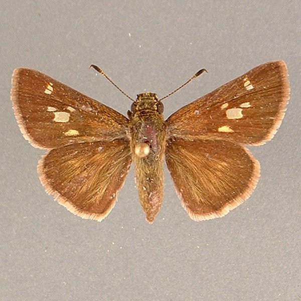
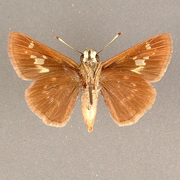
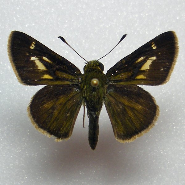
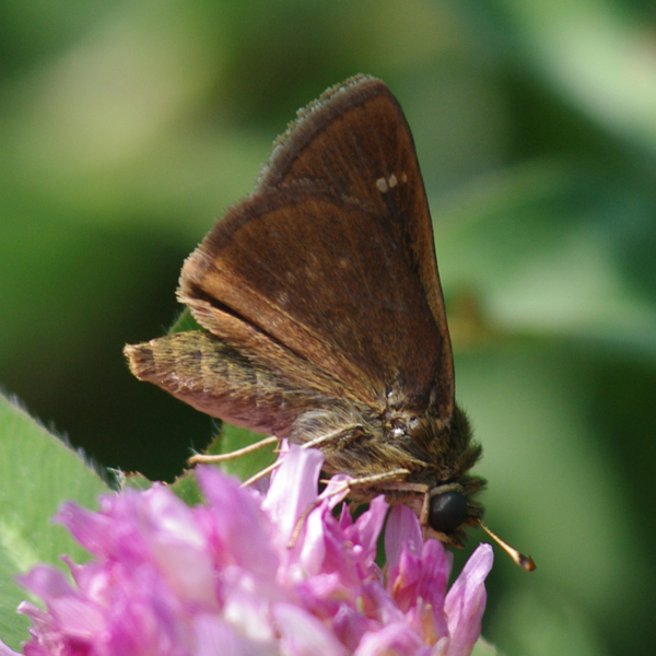
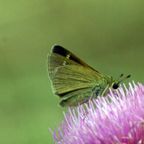
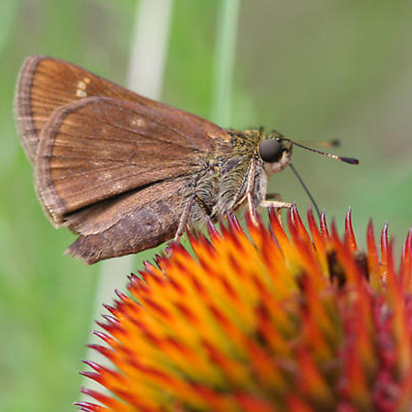
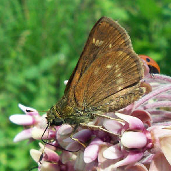
Little Glassywing (Vernia verna), (W H Edwards, 1862) - 4048.000000 - 77a0207
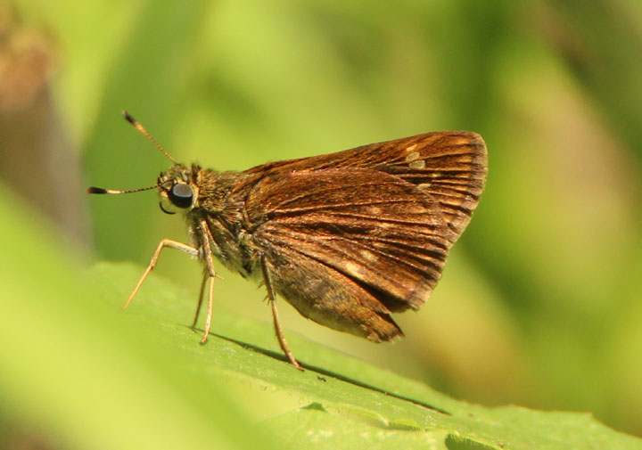
Wingspan: 3 cm.
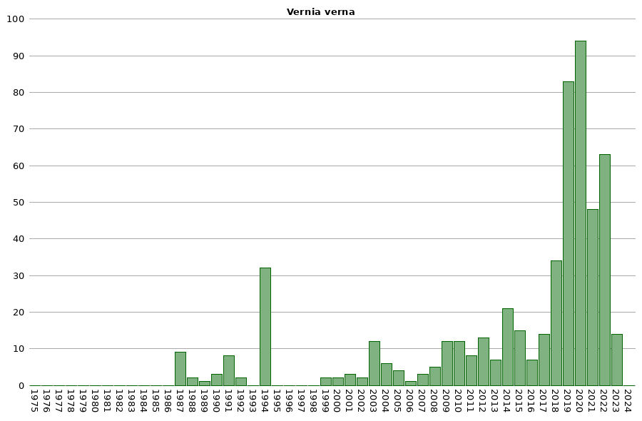
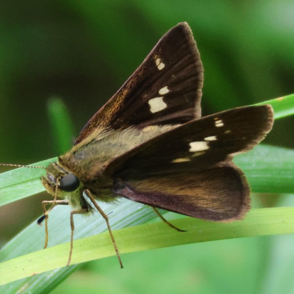
Flight time: A single brood flies generally from mid June to mid July.
Status: Breeding resident.
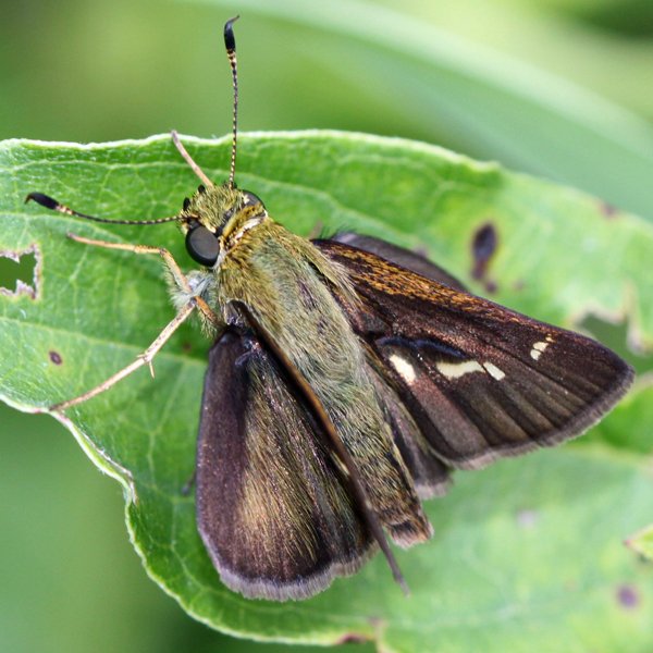
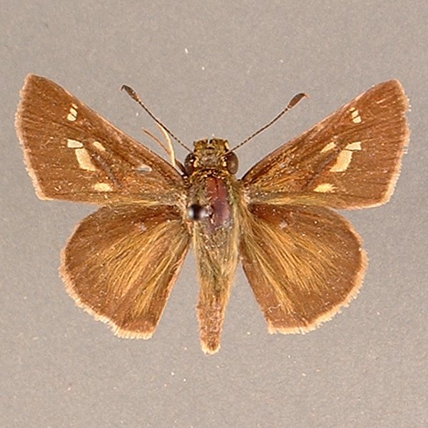
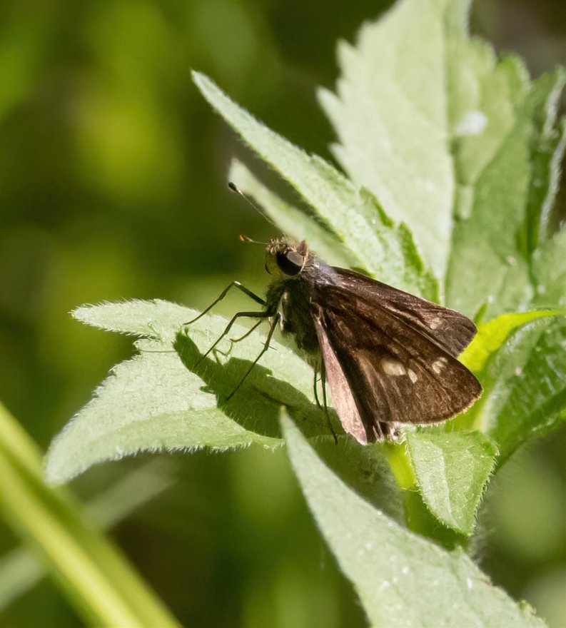
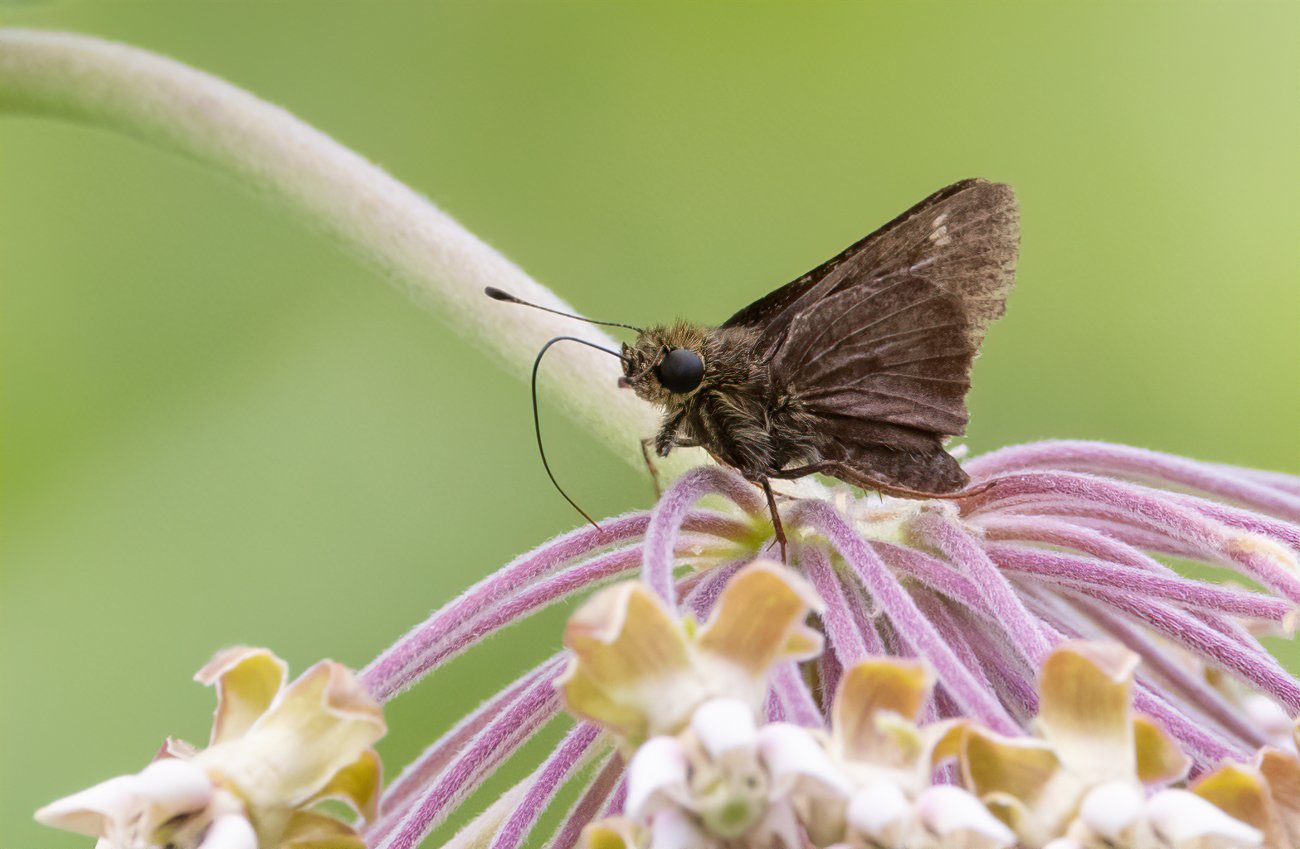
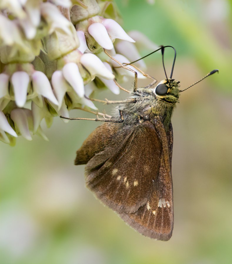
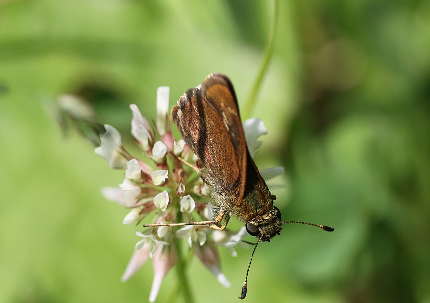
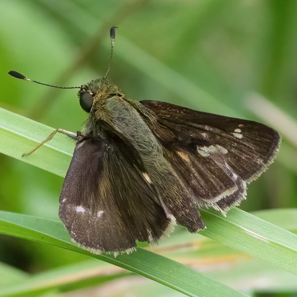
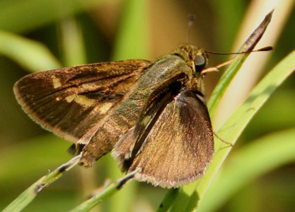
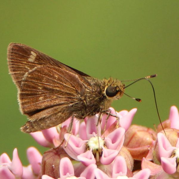
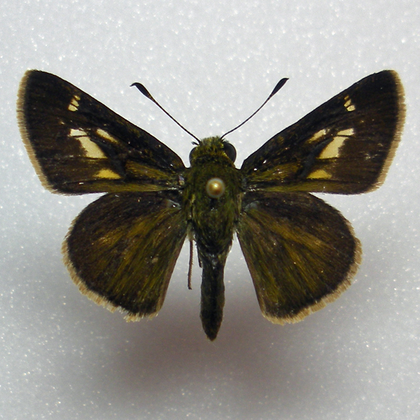
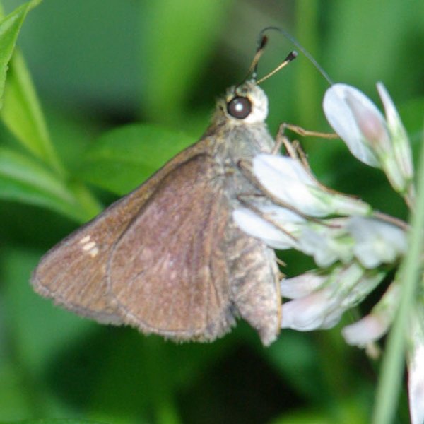
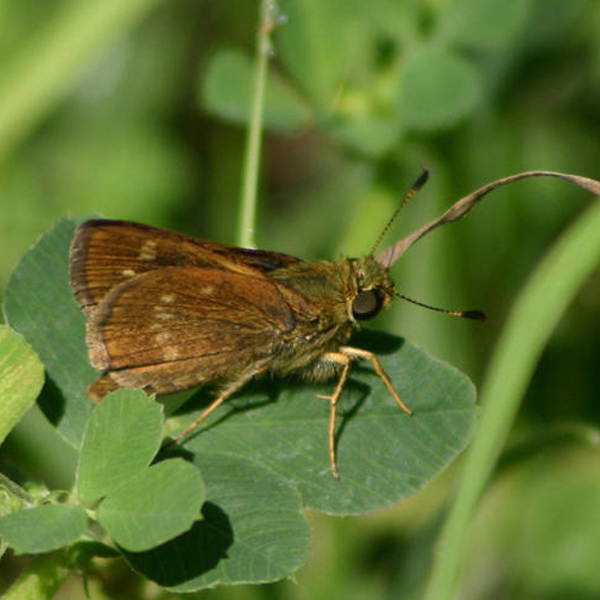
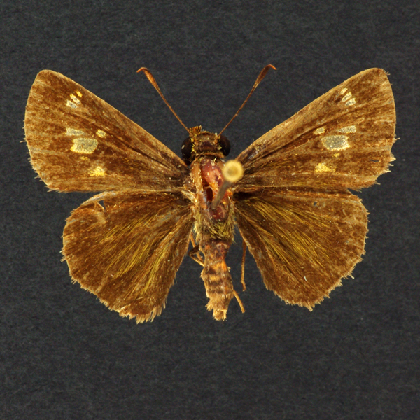
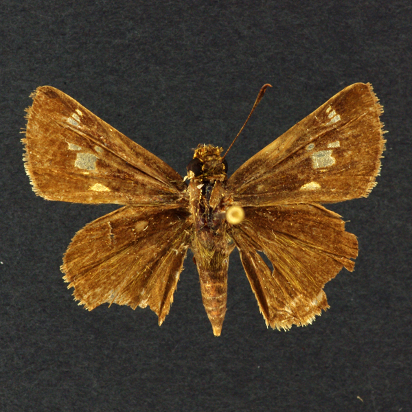
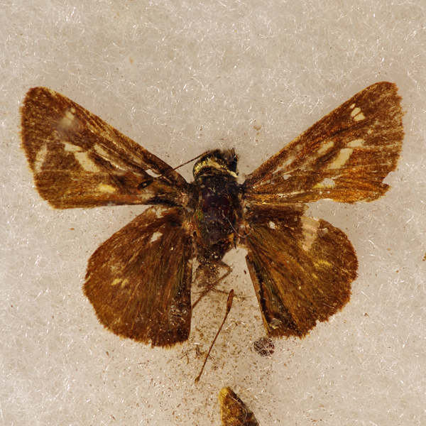
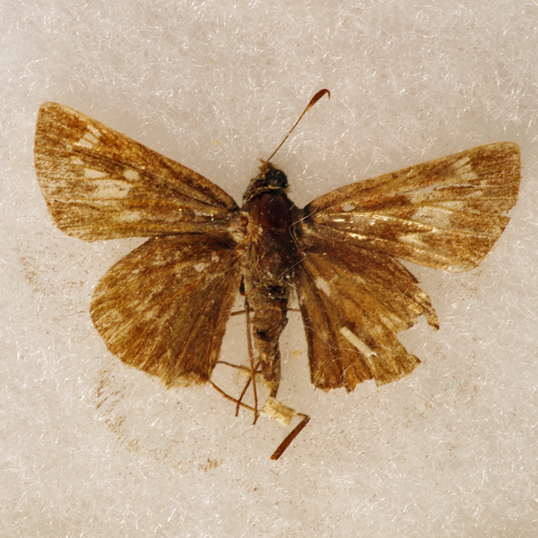
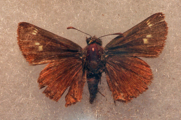
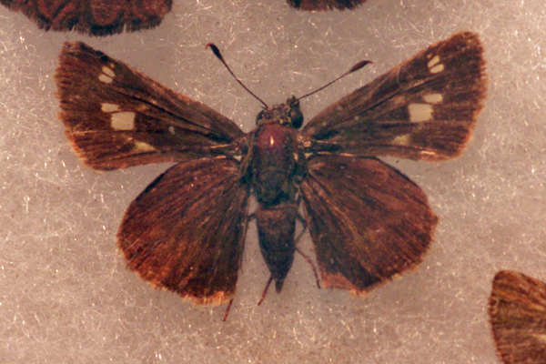
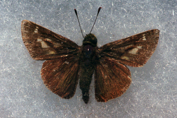
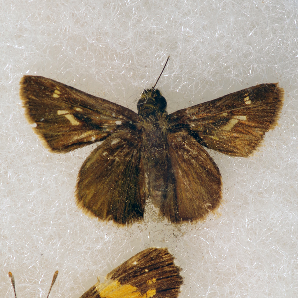
Distinguishing features: This uniformly dark brown skipper has one large and several small clear spots in the center of the upper forewing. The large spot is shaped like a parallelogram in males, and is rectangular in females.
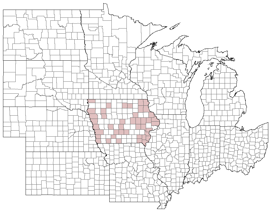
Distribution and habitat: The Little Glassy Wing occurs in scattered locations across the state. It seems to favor woodland margins.
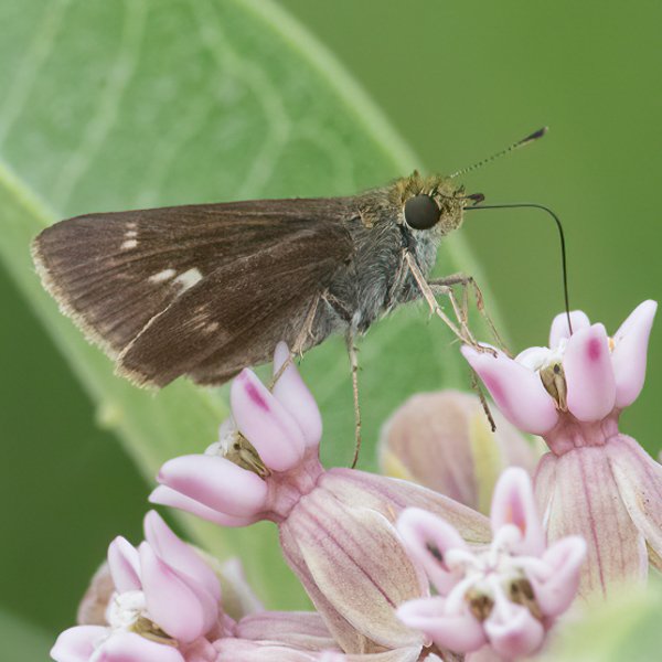
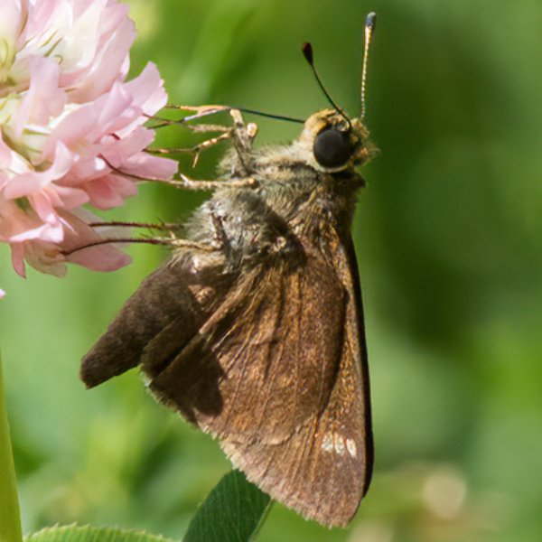
Natural History: The only listed larval host plant (Purpletop Grass) is absent from the bulk of Iowa sites, indicating that some other grass must be used for food. It avidly visits flowers such as milkweed, and is docile enough to be easily observed and photographed.


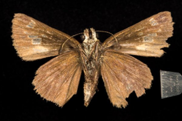
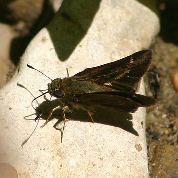
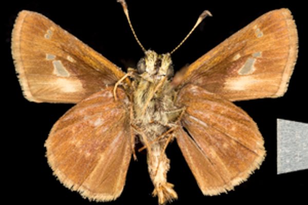
Photos

Records
| Record # | Date | Locale | State | Lat/Lon | Collected By | Count |
|---|---|---|---|---|---|---|
| 347018 | 2023-08-13 | Pammel State Park | Iowa | 41.294986 -94.074903 | Jay Gilliam | 1 |
| 347013 | 2023-08-12 | Turkey Run Wildlife Area, Lee County | Iowa | 40.557863 -91.680371 | Jay Gilliam | 1 |
 344128 344128
|
2023-07-02 | Prairiewoods Franciscan Spirituality Center | Iowa | 42.048527 -91.67118 | Frank Olsen | 1 |
 343191 343191
|
2023-06-25 | Shimek State Forest, Donnellson Unit | Iowa | 40.64482295 -91.67456035 | Mark Brown | 1 |
 346237 346237
|
2023-06-25 | Shimek State Forest, Croton Unit East | Iowa | 40.546129 -91.616172 | Jay Gilliam | 1 |
| 350115 | 2023-06-25 | Shimek State Forest, Croton Unit East | Iowa | 40.545896 -91.616881 | Chris Edwards | 13 |
| 350170 | 2023-06-25 | Shimek State Forest, Donnellson Unit | Iowa | 40.643603 -91.67741 | Chris Edwards | 13 |
| 350192 | 2023-06-25 | Shimek State Forest, Lick Creek Unit | Iowa | 40.61233 -91.685905 | Chris Edwards | 2 |
| 350251 | 2023-06-25 | Turkey Run Access | Iowa | 40.550644 -91.654633 | Chris Edwards | 1 |
| 350291 | 2023-06-25 | Turkey Run Wildlife Area, Lee County | Iowa | 40.558402 -91.679173 | Chris Edwards | 2 |
 346228 346228
|
2023-06-24 | Shimek State Forest, Donnellson Unit | Iowa | 40.637967 -91.666815 | Jay Gilliam | 1 |
 346230 346230
|
2023-06-24 | Shimek State Forest, Donnellson Unit | Iowa | 40.637967 -91.666815 | Jay Gilliam | 5 |
 335072 335072
|
2023-06-18 | Amana Woods Nature Trail | Iowa | 41.768642 -91.882164 | Mark Madsen | 1 |
| 362552 | 2023-06-16 | Jefferson County Park | Iowa | 40.989906 -91.990814 | IBSN | 3 |
| 330485 | 2022-07-03 | Cedar View Trail | Iowa | 40.99102 -92.005082 | IBSN | 3 |
| 317082 | 2022-07-02 | Rock Island Botanical State Preserve | Iowa | 42.02732 -91.72723 | Frank Olsen | 1 |
 318108 318108
|
2022-07-01 | Five Ridge Prairie State Preserve | Iowa | 42.679143 -96.523488 | Jay Gilliam | 1 |
| 330486 | 2022-06-29 | Jefferson County Park | Iowa | 40.989906 -91.990814 | IBSN | 1 |
| 318055 | 2022-06-26 | Pammel State Park | Iowa | 41.294986 -94.074903 | Jay Gilliam | 1 |
| 330484 | 2022-06-21 | Cedar View Trail | Iowa | 40.99102 -92.005082 | IBSN | 4 |
| 330483 | 2022-06-18 | Cedar View Trail | Iowa | 40.99102 -92.005082 | IBSN | 14 |
| 331239 | 2022-06-18 | Lee County | Iowa | 40.706886 -91.443349 | Chris Edwards | 8 |
| 331270 | 2022-06-18 | Shimek State Forest, Croton Unit East | Iowa | 40.545896 -91.616881 | Chris Edwards | 19 |
| 331298 | 2022-06-18 | Shimek State Forest, Donnellson Unit | Iowa | 40.643603 -91.67741 | Chris Edwards | 8 |
| 331338 | 2022-06-18 | Turkey Run Wildlife Area, Lee County | Iowa | 40.558402 -91.679173 | Chris Edwards | 2 |
| 317877 | 2022-06-05 | Slip Bluff County Park | Iowa | 40.652884 -93.847544 | Jay Gilliam | 1 |
| 306626 | 2021-07-17 | Cedar View Trail | Iowa | 40.990459 -92.005459 | IBSN | 2 |
| 308262 | 2021-07-17 | Effigy Mounds National Monument | Iowa | 43.100641 -91.183746 | Chris Edwards | 1 |
| 306625 | 2021-07-10 | Jefferson County Park | Iowa | 40.989906 -91.990814 | IBSN | 2 |
| 306630 | 2021-07-04 | Cedar View Trail | Iowa | 40.990459 -92.005459 | IBSN | 1 |
| 306629 | 2021-07-01 | Jefferson County Park | Iowa | 40.989906 -91.990814 | IBSN | 2 |
| 306627 | 2021-06-28 | Cedar View Trail | Iowa | 40.990459 -92.005459 | IBSN | 5 |
| 297630 | 2021-06-22 | Rock Island Botanical State Preserve | Iowa | 42.02732 -91.72723 | Frank Olsen | 1 |
| 307987 | 2021-06-19 | Lee County | Iowa | 0 0 | Chris Edwards | 1 |
| 308008 | 2021-06-19 | Shimek State Forest, Croton Unit East | Iowa | 40.545896 -91.616881 | Chris Edwards | 21 |
| 308031 | 2021-06-19 | Shimek State Forest, Donnellson Unit | Iowa | 40.643603 -91.67741 | Chris Edwards | 7 |
| 308077 | 2021-06-19 | Turkey Run Wildlife Area, Lee County | Iowa | 40.558402 -91.679173 | Chris Edwards | 1 |
 300575 300575
|
2021-06-18 | Rolling Thunder Prairie State Preserve | Iowa | 41.204306 -93.656457 | Jay Gilliam | 2 |
| 306628 | 2021-06-14 | Jefferson County Park | Iowa | 40.989906 -91.990814 | IBSN | 1 |
| 306631 | 2021-05-23 | Port Louisa National Wildlife Refuge | Iowa | 41.239649 -91.124611 | IBSN | 1 |
| 274115 | 2020-08-30 | Shimek State Forest, Croton Unit East | Iowa | 40.545472 -91.616246 | Frank Olsen | 1 |
| 286154 | 2020-07-04 | Cedar View Trail | Iowa | 40.990996 -92.004793 | IBSN | 1 |
| 275931 | 2020-07-03 | Pammel State Park | Iowa | 41.294986 -94.074903 | Jay Gilliam | 1 |
| 275810 | 2020-06-25 | Pammel State Park | Iowa | 41.294986 -94.074903 | Jay Gilliam | 1 |
| 273818 | 2020-06-23 | Prairiewoods Franciscan Spirituality Center | Iowa | 42.048527 -91.67118 | Frank Olsen | 1 |
 275156 275156
|
2020-06-21 | Wilcox Wildlife Area | Iowa | 41.238081 -92.956863 | Jay Gilliam | 1 |
 277887 277887
|
2020-06-21 | Shimek State Forest, Croton Unit East | Iowa | 40.54609014 -91.61590885 | Mark Brown | 1 |
| 281865 | 2020-06-21 | Shimek State Forest, Croton Unit East | Iowa | 40.545896 -91.616881 | Chris Edwards | 7 |
| 281866 | 2020-06-21 | Shimek State Forest, Donnellson Unit | Iowa | 40.643603 -91.67741 | Chris Edwards | 1 |
| 286152 | 2020-06-21 | Cedar View Trail | Iowa | 40.990996 -92.004793 | IBSN | 73 |
| 286153 | 2020-06-21 | Jefferson County Park | Iowa | 40.990015 -91.986398 | IBSN | 4 |
| 286151 | 2020-06-12 | Cedar View Trail | Iowa | 40.990996 -92.004793 | IBSN | 2 |
| 261616 | 2019-08-24 | Big Creek State Park | Iowa | 41.802522 -93.733288 | IBSN | 1 |
| 261633 | 2019-07-11 | Jefferson County Park | Iowa | 40.989906 -91.990814 | IBSN | 2 |
| 261627 | 2019-07-10 | Cedar View Trail | Iowa | 40.990459 -92.005459 | IBSN | 1 |
| 240556 | 2019-07-06 | Pohlman Prairie | Iowa | 42.560363 -90.749433 | Frank Olsen | 5 |
| 240570 | 2019-07-06 | Hamilton and Tapken Prairie Preserve | Iowa | 42.1775 -90.9975 | Frank Olsen | 2 |
| 240540 | 2019-07-05 | Manikowski Prairie State Preserve | Iowa | 41.972843 -90.375383 | Frank Olsen | 1 |
| 261626 | 2019-07-04 | Cedar View Trail | Iowa | 40.990459 -92.005459 | IBSN | 7 |
| 240516 | 2019-07-01 | Rock Island Botanical State Preserve | Iowa | 42.02732 -91.72723 | Frank Olsen | 1 |
| 261625 | 2019-06-29 | Cedar View Trail | Iowa | 40.990459 -92.005459 | IBSN | 19 |
| 261632 | 2019-06-28 | Jefferson County Park | Iowa | 40.989906 -91.990814 | IBSN | 3 |
| 261624 | 2019-06-26 | Cedar View Trail | Iowa | 40.990459 -92.005459 | IBSN | 9 |
| 261631 | 2019-06-25 | Jefferson County Park | Iowa | 40.989906 -91.990814 | IBSN | 1 |
| 240451 | 2019-06-23 | Rock Island Botanical State Preserve | Iowa | 42.02732 -91.72723 | Frank Olsen | 1 |
| 261630 | 2019-06-23 | Jefferson County Park | Iowa | 40.989906 -91.990814 | IBSN | 2 |
| 261623 | 2019-06-22 | Cedar View Trail | Iowa | 40.990459 -92.005459 | IBSN | 11 |
| 261629 | 2019-06-20 | Jefferson County Park | Iowa | 40.989906 -91.990814 | IBSN | 3 |
| 261622 | 2019-06-18 | Cedar View Trail | Iowa | 40.990459 -92.005459 | IBSN | 7 |
| 261628 | 2019-06-18 | Jefferson County Park | Iowa | 40.989906 -91.990814 | IBSN | 5 |
| 248721 | 2019-06-16 | Shimek State Forest, Donnellson Unit | Iowa | 40.643603 -91.67741 | Chris Edwards | 1 |
| 248736 | 2019-06-16 | Turkey Run Access | Iowa | 40.550644 -91.654633 | Chris Edwards | 1 |
 225227 225227
|
2018-08-03 | Decatur County, Iowa | Iowa | Location Protected | Sibylla Brown | 1 |
| 228689 | 2018-07-07 | Effigy Mounds National Monument | Iowa | 43.100641 -91.183746 | Chris Edwards | 6 |
| 228724 | 2018-07-07 | Yellow River State Forest | Iowa | 43.170603 -91.240395 | Chris Edwards | 1 |
| 261621 | 2018-07-01 | Cedar View Trail | Iowa | 40.990459 -92.005459 | IBSN | 5 |
| 261620 | 2018-06-27 | Cedar View Trail | Iowa | 40.990459 -92.005459 | IBSN | 4 |
| 261619 | 2018-06-23 | Cedar View Trail | Iowa | 40.990459 -92.005459 | IBSN | 7 |
 225359 225359
|
2018-06-16 | Shimek State Forest, Croton Unit East | Iowa | 40.54693 -91.61435 | Mark Brown | 1 |
| 228629 | 2018-06-16 | Shimek State Forest, Croton Unit East | Iowa | 40.545896 -91.616881 | Chris Edwards | 1 |
| 223421 | 2018-06-13 | Shimek State Forest, Croton Unit East | Iowa | 40.547147 -91.620541 | Frank Olsen | 1 |
| 261618 | 2018-06-13 | Cedar View Trail | Iowa | 40.990459 -92.005459 | IBSN | 5 |
| 261617 | 2018-06-08 | Cedar View Trail | Iowa | 40.990459 -92.005459 | IBSN | 2 |
| 202204 | 2017-08-19 | Decatur County, Iowa | Iowa | Location Protected | Sibylla Brown | 1 |
| 202203 | 2017-08-14 | Decatur County, Iowa | Iowa | Location Protected | Sibylla Brown | 1 |
| 202202 | 2017-07-25 | Decatur County, Iowa | Iowa | Location Protected | Sibylla Brown | 1 |
| 203130 | 2017-07-08 | Effigy Mounds National Monument | Iowa | 43.100641 -91.183746 | Chris Edwards | 3 |
 202548 202548
|
2017-07-04 | Bellvue | Iowa | 42.25883 -90.42433 | Mark Brown | 1 |
| 203128 | 2017-06-24 | Shimek State Forest Count Circle | Iowa | 40.588416 -91.686616 | Chris Edwards | 2 |
| 203129 | 2017-06-24 | Shimek State Forest, Croton Unit East | Iowa | 40.545896 -91.616881 | Chris Edwards | 2 |
| 199617 | 2017-06-23 | Rock Island Botanical State Preserve | Iowa | 42.0258 -91.72638 | Frank Olsen | 3 |
| 183990 | 2016-07-16 | MacBride Nature Recreation Area | Iowa | 41.786242 -91.566399 | Chris Edwards | 1 |
| 180479 | 2016-07-09 | Hamilton Prairie, Jackson County | Iowa | 42.07133 -90.559 | Frank Olsen | 2 |
| 183844 | 2016-06-18 | Shimek State Forest, Croton Unit East | Iowa | 40.545896 -91.616881 | Chris Edwards | 3 |
| 180401 | 2016-06-07 | Shimek State Forest, Lick Creek Unit | Iowa | 40.610279 -91.672204 | Frank Olsen | 1 |
| 183568 | 2015-07-12 | Effigy Mounds National Monument | Iowa | 43.100641 -91.183746 | Chris Edwards | 1 |
| 353562 | 2015-06-25 | Black Hawk Point Wildlife Management Area | Iowa | 43.45949 -91.29776 | Kirk J. Larsen | 1 |
| 183514 | 2015-06-21 | Shimek State Forest, Croton Unit East | Iowa | 40.545896 -91.616881 | Chris Edwards | 13 |
| 68479 | 2014-07-19 | MacBride Nature Recreation Area | Iowa | 41.78611111 -91.56083333 | Tom Jantscher | 1 |
| 68531 | 2014-07-19 | Lake MacBride State Park | Iowa | 41.79555556 -91.545 | Tom Jantscher | 1 |
| 118850 | 2014-07-19 | MacBride Nature Recreation Area | Iowa | 41.786242 -91.566399 | Chris Edwards | 1 |
| 118852 | 2014-07-19 | Lake MacBride State Park | Iowa | 41.800146 -91.555669 | Chris Edwards | 1 |
| 68314 | 2014-07-13 | Effigy Mounds National Monument | Iowa | 43.100641 -91.183746 | Tom Jantscher | 1 |
| 68315 | 2014-07-13 | Effigy Mounds National Monument | Iowa | 43.100641 -91.183746 | Tom Jantscher | 1 |
| 68316 | 2014-07-13 | Effigy Mounds National Monument | Iowa | 43.100641 -91.183746 | Tom Jantscher | 1 |
| 68317 | 2014-07-13 | Effigy Mounds National Monument | Iowa | 43.100641 -91.183746 | Tom Jantscher | 1 |
| 118859 | 2014-07-13 | Effigy Mounds National Monument | Iowa | 43.100641 -91.183746 | Chris Edwards | 4 |
| 118831 | 2014-07-03 | Shimek State Forest, Croton Unit East | Iowa | 40.545896 -91.616881 | Chris Edwards | 1 |
| 118843 | 2014-07-03 | Shimek State Forest, Donnellson Unit | Iowa | 40.643603 -91.67741 | Chris Edwards | 1 |
| 118856 | 2014-07-03 | Shimek State Forest, Donnellson Unit | Iowa | 40.643603 -91.67741 | Chris Edwards | 1 |
| 7371 | 2014-06-25 | Sylvan Runkel State Preserve | Iowa | 42.105 -95.98233 | Aaron Brees | 1 |
| 67755 | 2014-06-25 | Sylvan Runkel State Preserve | Iowa | 42.105 -95.98233 | Aaron Brees | 1 |
 67918 67918
|
2014-06-14 | Shimek State Forest, Donnellson Unit | Iowa | 40.6455556 -91.6869444 | Tom Jantscher | 1 |
| 67931 | 2014-06-14 | Shimek State Forest, Donnellson Unit | Iowa | 40.6455556 -91.6869444 | Tom Jantscher | 1 |
| 68011 | 2014-06-14 | MacBride Nature Recreation Area | Iowa | 41.787377 -91.560187 | Tom Jantscher | 1 |
| 68040 | 2014-06-14 | MacBride Nature Recreation Area | Iowa | 41.787377 -91.560187 | Tom Jantscher | 1 |
 353563 353563
|
2013-07-23 | Black Hawk Point Wildlife Management Area | Iowa | 43.45949 -91.29776 | Sharon Heyer | 1 |
| 118849 | 2013-07-14 | MacBride Nature Recreation Area | Iowa | 41.786242 -91.566399 | Chris Edwards | 2 |
| 120398 | 2013-07-11 | Timberhill | Iowa | 40.715921 -93.651635 | Sibylla Brown | 1 |
| 136372 | 2013-07-11 | Decatur County, Iowa | Iowa | Location Protected | Sibylla Brown | 1 |
| 5446 | 2013-07-05 | Sylvan Runkel State Preserve | Iowa | 42.1027678 -95.971841 | BAMONA | 1 |
| 9903 | 2013-07-05 | Sylvan Runkel State Preserve | Iowa | 42.1027778 -95.9719444 | Tom Jantscher | 1 |
| 118830 | 2012-06-25 | Shimek State Forest, Croton Unit East | Iowa | 40.545896 -91.616881 | Chris Edwards | 5 |
| 118833 | 2012-06-25 | Shimek State Forest, Croton Unit West | Iowa | 40.566286 -91.658401 | Chris Edwards | 2 |
| 118842 | 2012-06-25 | Shimek State Forest, Donnellson Unit | Iowa | 40.643603 -91.67741 | Chris Edwards | 3 |
| 118855 | 2012-06-25 | Shimek State Forest, Donnellson Unit | Iowa | 40.643603 -91.67741 | Chris Edwards | 1 |
| 61911 | 2012-06-16 | Rock Island Botanical State Preserve | Iowa | 42.02732 -91.72723 | Frank Olsen | 1 |
 187711 187711
|
2012-06-08 | Whiterock Conservancy | Iowa | 41.817373 -94.645223 | Jim Durbin | 1 |
| 118858 | 2011-07-17 | Effigy Mounds National Monument | Iowa | 43.100641 -91.183746 | Chris Edwards | 1 |
| 118829 | 2011-07-04 | Shimek State Forest, Croton Unit East | Iowa | 40.545896 -91.616881 | Chris Edwards | 4 |
| 9901 | 2011-06-26 | Rock Island Botanical State Preserve | Iowa | 42.0269444 -91.7313889 | Tom Jantscher | 2 |
| 9900 | 2011-06-19 | Rock Island Botanical State Preserve | Iowa | 42.0258333 -91.7272222 | Tom Jantscher | 1 |
| 118828 | 2010-07-01 | Shimek State Forest, Croton Unit East | Iowa | 40.545896 -91.616881 | Chris Edwards | 6 |
| 118838 | 2010-07-01 | Shimek State Forest, Farmington Unit | Iowa | 40.653998 -91.72554 | Chris Edwards | 1 |
| 118848 | 2010-06-26 | MacBride Nature Recreation Area | Iowa | 41.786242 -91.566399 | Chris Edwards | 2 |
 227786 227786
|
2010-06-16 | Leon's Farm, Ohio County | Kentucky | 37.42033 -86.77023 | Jim Durbin | 1 |
 138534 138534
|
2010-06-12 | Hitchcock Nature Center | Iowa | 41.416 -95.8495 | Brian Peterson | 1 |
| 61913 | 2010-06-06 | Shimek State Forest, Croton Unit East | Iowa | 40.54693 -91.61435 | Frank Olsen | 1 |
| 353167 | 2009-07-22 | Anderson Prairie, Decorah | Iowa | 43.315099 -91.800701 | Peter Kraus | 1 |
| 118857 | 2009-07-03 | Effigy Mounds National Monument | Iowa | 43.100641 -91.183746 | Chris Edwards | 3 |
| 118841 | 2009-06-22 | Shimek State Forest, Donnellson Unit | Iowa | 40.643603 -91.67741 | Chris Edwards | 1 |
| 118854 | 2009-06-22 | Shimek State Forest, Donnellson Unit | Iowa | 40.643603 -91.67741 | Chris Edwards | 5 |
| 7370 | 2009-06-20 | Shimek State Forest, Croton Unit East | Iowa | 40.54693 -91.61435 | Aaron Brees | 1 |
 227738 227738
|
2009-06-13 | Leon's Farm, Ohio County | Kentucky | 37.42033 -86.77023 | Jim Durbin | 1 |
 208386 208386
|
2008-07-07 | Elk Rock State Park | Iowa | 41.4022 -93.0851 | Aaron Brees | 1 |
| 118832 | 2008-06-21 | Shimek State Forest, Croton Unit West | Iowa | 40.566286 -91.658401 | Chris Edwards | 1 |
| 118840 | 2008-06-21 | Shimek State Forest, Donnellson Unit | Iowa | 40.643603 -91.67741 | Chris Edwards | 2 |
 266478 266478
|
2008-04-14 | Brazos Bend State Park | Texas | 29.37018 -95.625884 | Jim Durbin | 1 |
| 118847 | 2007-07-01 | MacBride Nature Recreation Area | Iowa | 41.786242 -91.566399 | Chris Edwards | 1 |
| 118839 | 2007-06-15 | Shimek State Forest, Donnellson Unit | Iowa | 40.643603 -91.67741 | Chris Edwards | 1 |
| 118853 | 2007-06-15 | Shimek State Forest, Donnellson Unit | Iowa | 40.643603 -91.67741 | Chris Edwards | 1 |
| 61899 | 2006-07-10 | Rockford Fossil & Prairie Park Preserve | Iowa | 43.04778 -92.97113 | Frank Olsen | 1 |
| 118837 | 2005-07-02 | Shimek State Forest Count Circle | Iowa | 40.588416 -91.686616 | Chris Edwards | 1 |
| 61912 | 2005-06-26 | Shimek State Forest, Croton Unit East | Iowa | 40.54693 -91.61435 | Frank Olsen | 1 |
 144070 144070
|
2005-06-18 | Shimek State Forest, Lick Creek Unit | Iowa | 40.609292 -91.67218 | Mark Brown | 1 |
 144071 144071
|
2005-06-11 | Shimek State Forest, Lick Creek Unit | Iowa | 40.609227 -91.672438 | Mark Brown | 1 |
| 118836 | 2004-06-19 | Shimek State Forest Count Circle | Iowa | 40.588416 -91.686616 | Chris Edwards | 6 |
| 118845 | 2003-07-05 | F. W. Kent Park | Iowa | 41.72916 -91.727161 | Chris Edwards | 1 |
| 118835 | 2003-06-30 | Shimek State Forest Count Circle | Iowa | 40.588416 -91.686616 | Chris Edwards | 7 |
| 118846 | 2003-06-29 | MacBride Nature Recreation Area | Iowa | 41.786242 -91.566399 | Chris Edwards | 2 |
| 118844 | 2003-06-28 | Hickory Hill Park | Iowa | 41.671284 -91.509824 | Chris Edwards | 2 |
| 61910 | 2002-07-05 | Rock Island Botanical State Preserve | Iowa | 42.02732 -91.72723 | Frank Olsen | 1 |
| 144526 | 2002-07-05 | Rock Island Botanical State Preserve | Iowa | 42.026205 -91.726516 | Frank Olsen | 1 |
| 144586 | 2001-07-26 | Seed Saver Exchange | Iowa | 43.384074 -91.80893 | Frank Olsen | 1 |
| 118860 | 2001-06-23 | Yellow River State Forest | Iowa | 43.170603 -91.240395 | Chris Edwards | 1 |
| 118834 | 2001-06-18 | Shimek State Forest Count Circle | Iowa | 40.588416 -91.686616 | Chris Edwards | 1 |
 137213 137213
|
2000-07-08 | Ames, Paul | Iowa | 42.016928 -93.615791 | Paul Martsching | 1 |
| 144490 | 2000-06-29 | Wickiup Hill Outdoor Learning Area | Iowa | 42.08398 -91.7651 | Frank Olsen | 1 |
 137214 137214
|
1999-07-14 | Wakefield Woods | Iowa | 42.077447 -93.57976 | Paul Martsching | 1 |
| 118851 | 1999-07-03 | Lake MacBride State Park | Iowa | 41.800146 -91.555669 | Chris Edwards | 1 |
| 61897 | 1994-07-16 | Cedar Hills Sand Prairie Preserve | Iowa | 42.59305 -92.55315 | Ed Freese | 1 |
| 61903 | 1994-07-10 | Indian Creek Nature Center | Iowa | 41.9664 -91.5806 | Frank Olsen | 1 |
 144469 144469
|
1994-07-10 | Indian Creek Nature Center | Iowa | 41.96611 -91.57934 | Frank Olsen | 1 |
 144464 144464
|
1994-07-03 | Indian Creek Nature Center | Iowa | 41.96611 -91.57934 | Frank Olsen | 4 |
| 271932 | 1994-06-25 | Fayette County | Iowa | 0 0 | Ron Harms | 23 |
| 61902 | 1994-06-18 | Indian Creek Nature Center | Iowa | 41.9664 -91.5806 | Frank Olsen | 1 |
 144458 144458
|
1994-06-18 | Indian Creek Nature Center | Iowa | 41.96611 -91.57934 | Frank Olsen | 1 |
| 61901 | 1992-08-01 | Hitaga Sand Ridge Prairie Preserve | Iowa | 42.25233 -91.63633 | Frank Olsen | 1 |
 144435 144435
|
1992-08-01 | Hitaga Sand Ridge Prairie Preserve | Iowa | 42.24944 -91.63056 | Frank Olsen | 1 |
| 107740 | 1991-08-23 | Mount Talbot State Preserve | Iowa | 42.564493 -96.469729 | Tim Orwig | 1 |
 144377 144377
|
1991-07-21 | Rock Island Botanical State Preserve | Iowa | 42.026205 -91.726516 | Frank Olsen | 1 |
 144370 144370
|
1991-06-24 | Rock Island Botanical State Preserve | Iowa | 42.026205 -91.726516 | Frank Olsen | 1 |
 144372 144372
|
1991-06-24 | Wanatee County Park | Iowa | 42.00994 -91.57749 | Frank Olsen | 1 |
| 61918 | 1991-06-23 | Wanatee County Park | Iowa | 42.00994 -91.57749 | Frank Olsen | 1 |
 144365 144365
|
1991-06-23 | Wanatee County Park | Iowa | 42.00994 -91.57749 | Frank Olsen | 1 |
| 61909 | 1991-06-15 | Rock Island Botanical State Preserve | Iowa | 42.02732 -91.72723 | Frank Olsen | 1 |
| 144359 | 1991-06-15 | Rock Island Botanical State Preserve | Iowa | 42.026205 -91.726516 | Frank Olsen | 1 |
| 61916 | 1990-06-24 | Shimek State Forest, Donnellson Unit | Iowa | 40.64517 -91.66783 | Tim Orwig | 2 |
 144577 144577
|
1990-06-24 | Shimek State Forest, Farmington Unit | Iowa | 40.647836 -91.725104 | Frank Olsen | 1 |
| 61898 | 1989-07-21 | Five Ridge Prairie State Preserve | Iowa | 42.67867 -96.53473 | Tim Orwig | 1 |
| 61914 | 1988-06-23 | Shimek State Forest, Croton Unit East | Iowa | 40.54693 -91.61435 | Tim Orwig | 1 |
| 61915 | 1988-06-23 | Shimek State Forest, Croton Unit East | Iowa | 40.54693 -91.61435 | Tim Orwig | 1 |
| 61906 | 1987-06-29 | Black Hawk Point Wildlife Management Area | Iowa | 43.45604 -91.30837 | John G. Nehnevaj | 1 |
| 358511 | 1987-06-29 | Allamakee Sand Cove | Iowa | 43.436325 -91.30626 | John G. Nehnevaj | 1 |
| 61905 | 1987-06-27 | Black Hawk Point Wildlife Management Area | Iowa | 43.45604 -91.30837 | John G. Nehnevaj | 1 |
| 353538 | 1987-06-27 | Black Hawk Point Wildlife Management Area | Iowa | 43.45949 -91.29776 | John G. Nehnevaj | 1 |
| 61900 | 1987-06-21 | Gitchie Manitou State Preserve | Iowa | 43.4997 -96.5983 | Tim Orwig | 1 |
| 61919 | 1987-06-21 | Clear Creek Fen | Iowa | 43.455306 -91.42388 | John G. Nehnevaj | 1 |
| 358097 | 1987-06-21 | Potter's Prairie | Iowa | 43.4825 -91.412333 | John G. Nehnevaj | 1 |
 358098 358098
|
1987-06-21 | Potter's Prairie | Iowa | 43.4825 -91.412333 | John G. Nehnevaj | 1 |
| 61917 | 1987-06-18 | Sioux City State Prairie Preserve | Iowa | 42.5241 -96.4362 | Tim Orwig | 1 |
| 61907 | 1961-07-02 | Shimek State Forest, Croton Unit East | Iowa | 40.54575 -91.61623 | St. Ambrose Univ. | 1 |
| 61908 | 1961-07-02 | Shimek State Forest, Croton Unit East | Iowa | 40.54575 -91.61623 | St. Ambrose Univ. | 1 |
| 5427 | 1950-06-20 | Allamakee County | Iowa | 43.243076 -91.443466 | USGS - NPWRC | 1 |
| 5428 | 1950-06-20 | Benton County | Iowa | 42.138725 -92.066521 | USGS - NPWRC | 1 |
| 5429 | 1950-06-20 | Black Hawk County | Iowa | 42.447803 -92.381363 | USGS - NPWRC | 1 |
| 5430 | 1950-06-20 | Buena Vista County | Iowa | 42.670544 -95.143204 | USGS - NPWRC | 1 |
| 5431 | 1950-06-20 | Cerro Gordo County | Iowa | 43.048603 -93.33889 | USGS - NPWRC | 1 |
| 5432 | 1950-06-20 | Clayton County | Iowa | 42.77853 -91.289101 | USGS - NPWRC | 1 |
| 5433 | 1950-06-20 | Decatur County | Iowa | 40.814648 -93.824821 | USGS - NPWRC | 1 |
| 5434 | 1950-06-20 | Des Moines County | Iowa | 40.912338 -91.173698 | USGS - NPWRC | 1 |
| 5435 | 1950-06-20 | Sidney | Iowa | 40.74004 -95.645798 | USGS - NPWRC | 1 |
| 5436 | 1950-06-20 | Harrison County | Iowa | 41.693386 -95.814285 | USGS - NPWRC | 1 |
| 5437 | 1950-06-20 | Henry County | Iowa | 41.028358 -91.598396 | USGS - NPWRC | 1 |
| 5438 | 1950-06-20 | Jefferson County | Iowa | 41.023636 -91.909927 | USGS - NPWRC | 1 |
| 5439 | 1950-06-20 | Johnson County | Iowa | 41.669899 -91.598396 | USGS - NPWRC | 1 |
| 5440 | 1950-06-20 | Lee County | Iowa | 40.706867 -91.443466 | USGS - NPWRC | 1 |
| 5441 | 1950-06-20 | Linn County | Iowa | 42.027289 -91.67275 | USGS - NPWRC | 1 |
| 5442 | 1950-06-20 | Lyon County | Iowa | 43.3936 -96.2479 | USGS - NPWRC | 1 |
| 5443 | 1950-06-20 | Madison County | Iowa | 41.292236 -93.987846 | USGS - NPWRC | 1 |
| 5444 | 1950-06-20 | Mills County | Iowa | 41.06245 -95.645798 | USGS - NPWRC | 1 |
| 5445 | 1950-06-20 | Monona County | Iowa | 42.001595 -95.983261 | USGS - NPWRC | 1 |
| 5447 | 1950-06-20 | Muscatine County | Iowa | 41.51569 -91.1353 | USGS - NPWRC | 1 |
| 5448 | 1950-06-20 | Palo Alto County | Iowa | 43.158089 -94.645035 | USGS - NPWRC | 1 |
| 5449 | 1950-06-20 | Plymouth County | Iowa | 42.776665 -96.152695 | USGS - NPWRC | 1 |
| 5450 | 1950-06-20 | Sac County | Iowa | 42.357353 -95.143204 | USGS - NPWRC | 1 |
| 5451 | 1950-06-20 | Tama County | Iowa | 42.129257 -92.539604 | USGS - NPWRC | 1 |
| 5452 | 1950-06-20 | Taylor County | Iowa | 40.784607 -94.645035 | USGS - NPWRC | 1 |
| 5453 | 1950-06-20 | Union County | Iowa | 41.000687 -94.274361 | USGS - NPWRC | 1 |
| 5454 | 1950-06-20 | Van Buren County | Iowa | 40.700115 -91.909927 | USGS - NPWRC | 1 |
| 5455 | 1950-06-20 | Warren County | Iowa | 41.308056 -93.500343 | USGS - NPWRC | 1 |
| 5456 | 1950-06-20 | Winneshiek County | Iowa | 43.236259 -91.909927 | USGS - NPWRC | 1 |
| 5457 | 1950-06-20 | Woodbury County | Iowa | 42.316616 -95.983261 | USGS - NPWRC | 1 |