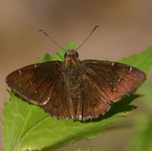
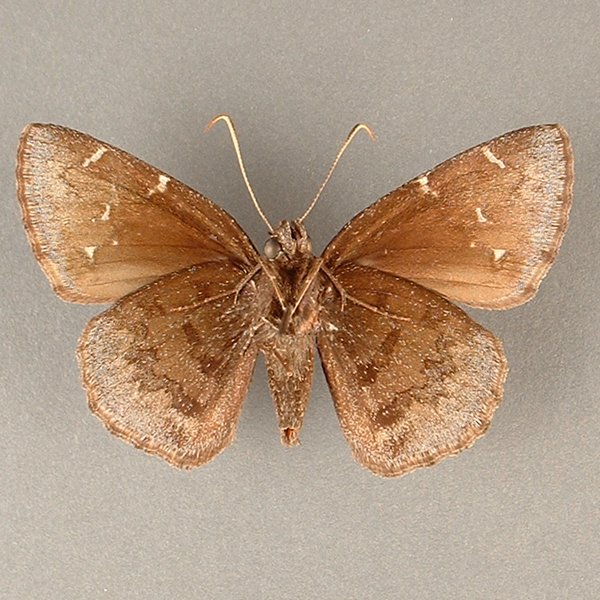
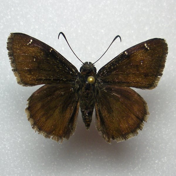
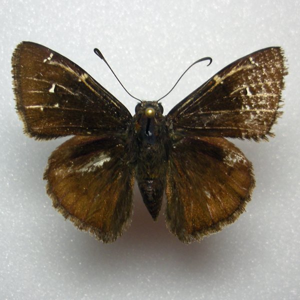
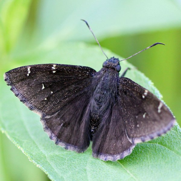
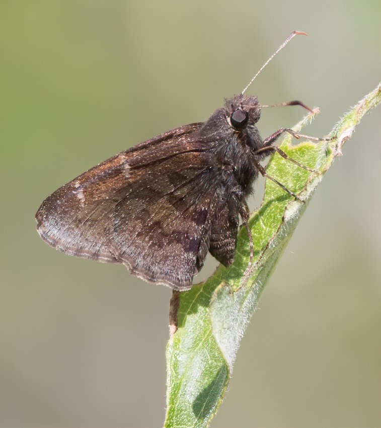
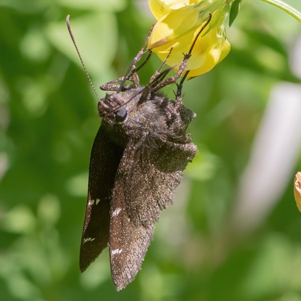
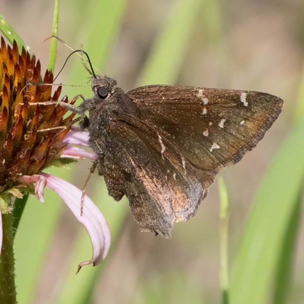
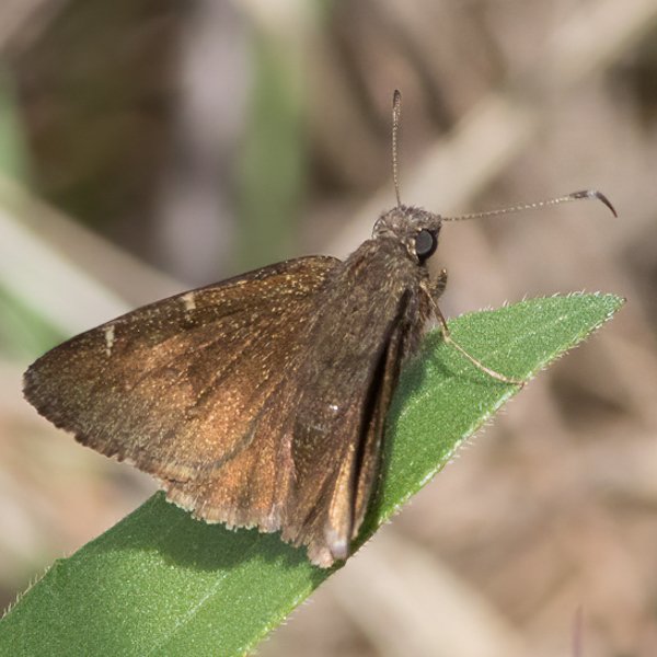
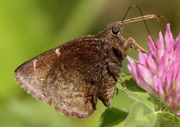
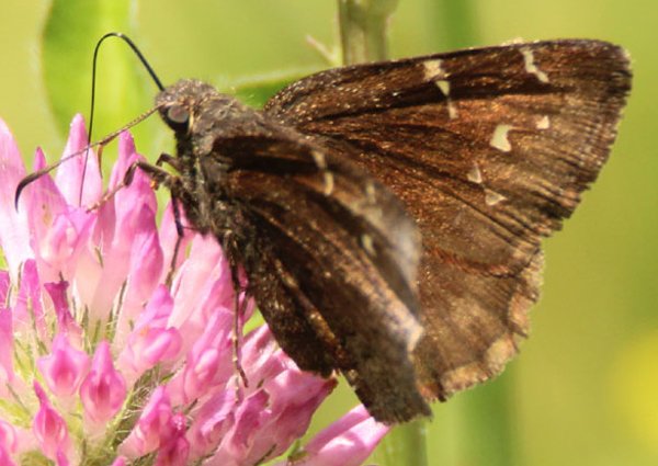
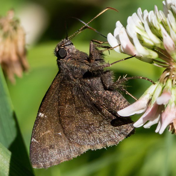
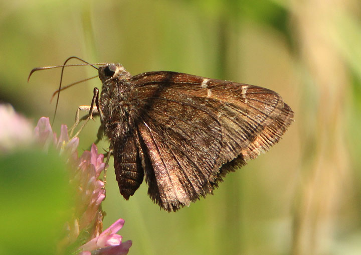
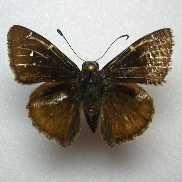
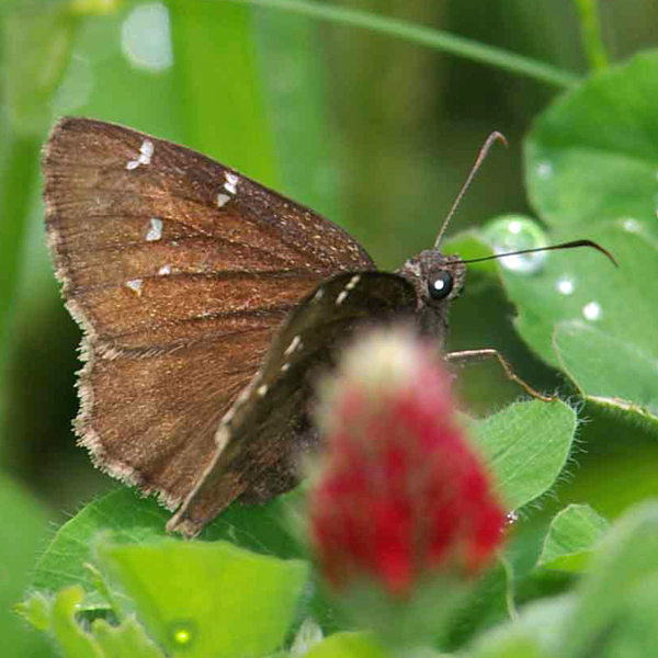
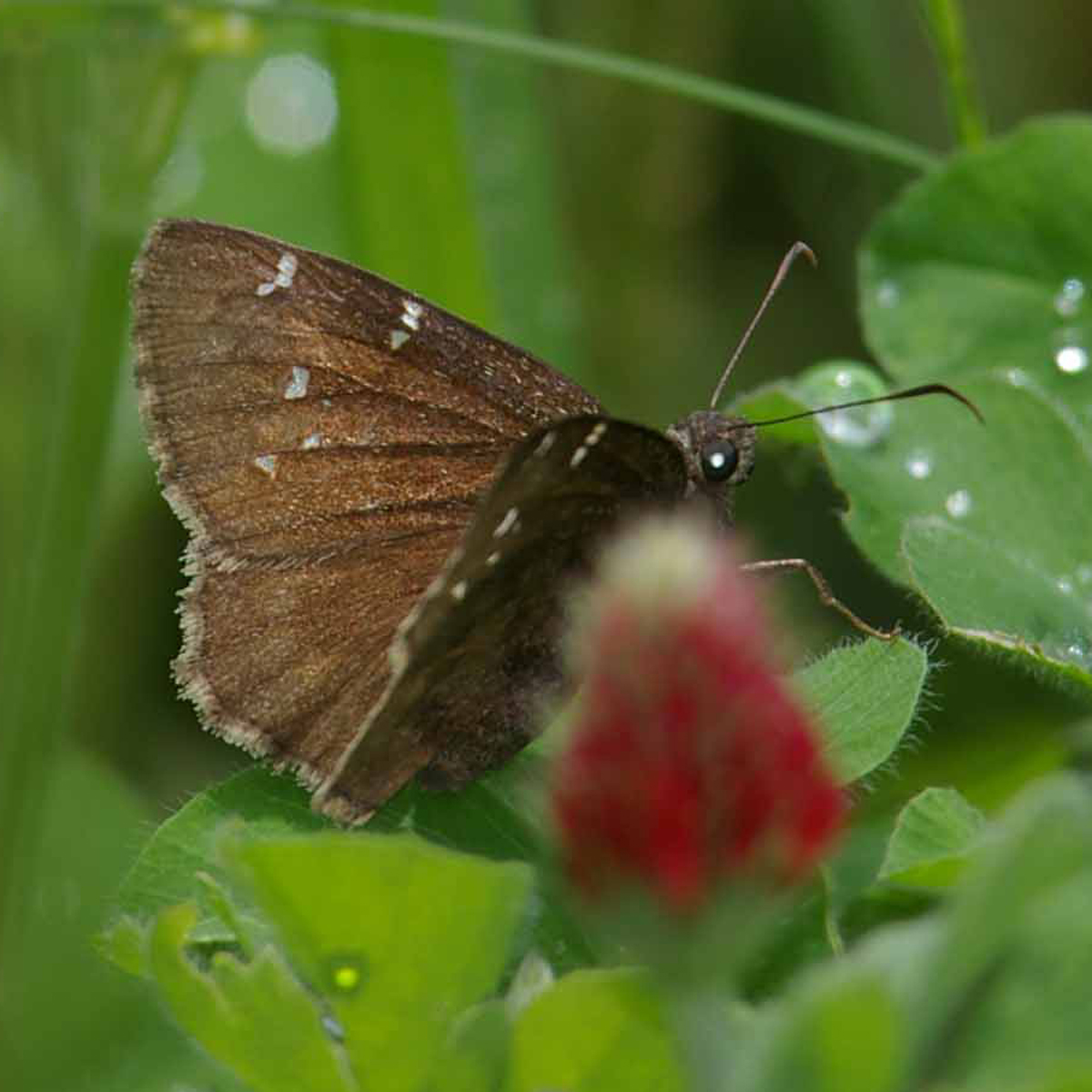
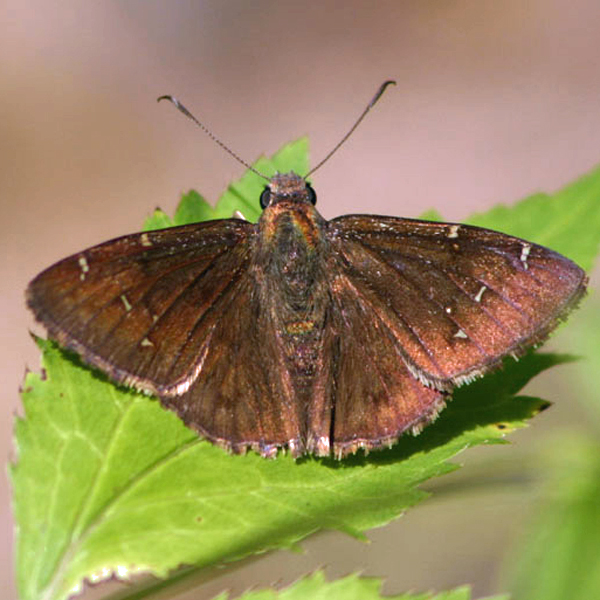
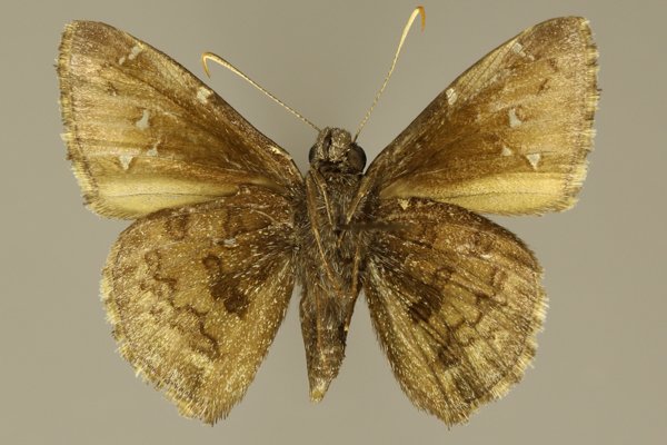
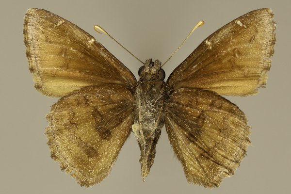
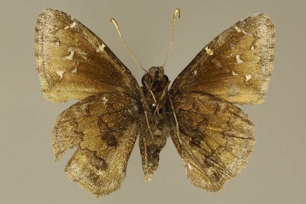
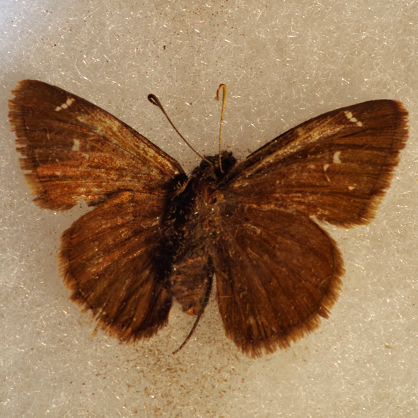
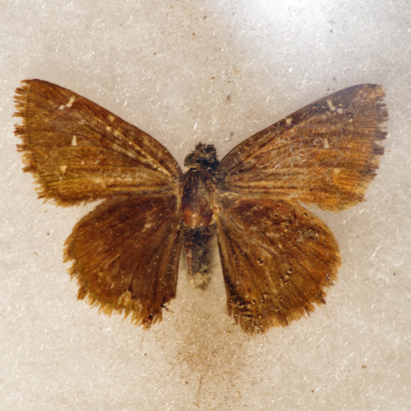
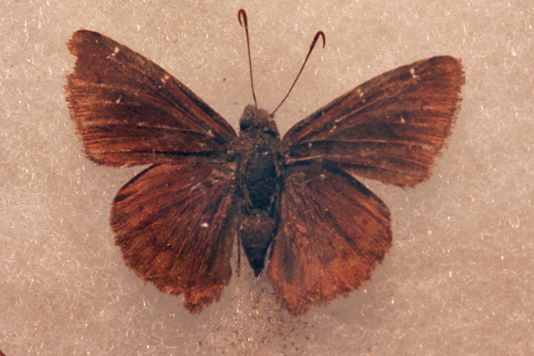
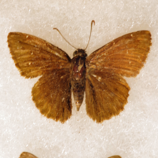
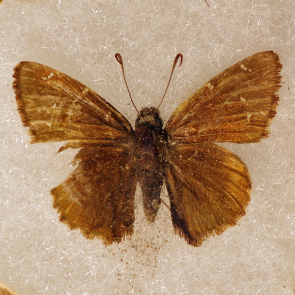
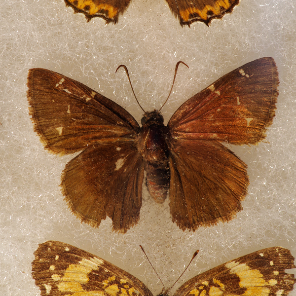
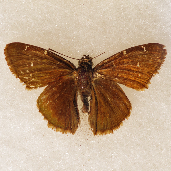
Wing span: 3.4-4.0 cm.
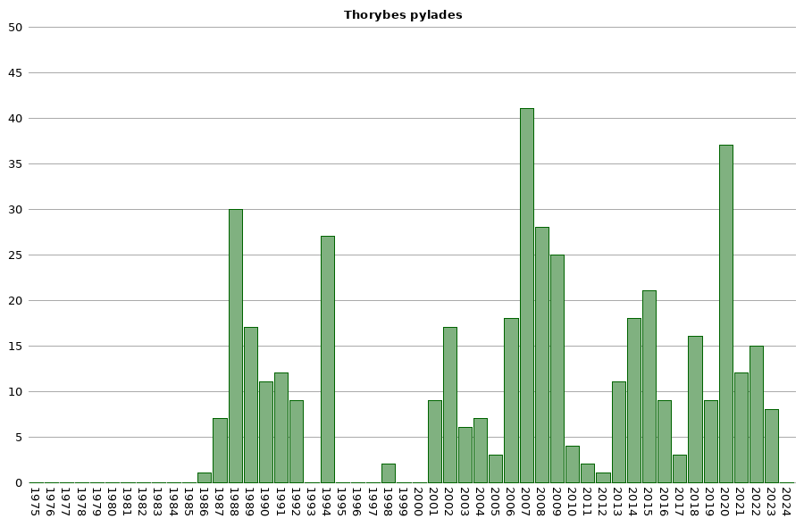
Flight time: Essentially univoltine, with adults flying from early May to mid August. The bulk of individuals have been collected from the last few days of May through the first week of July.
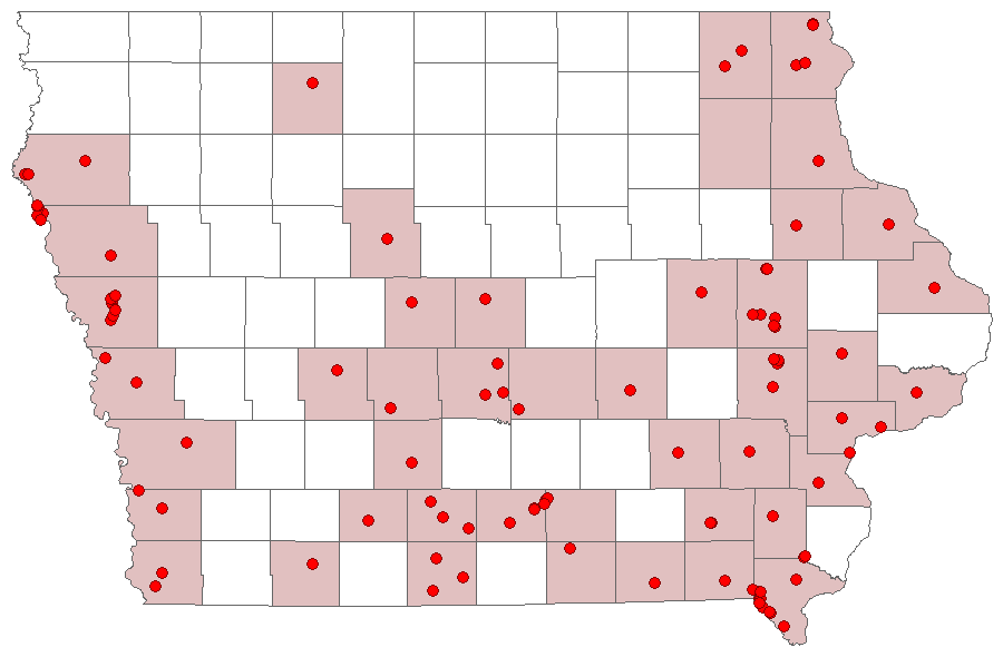
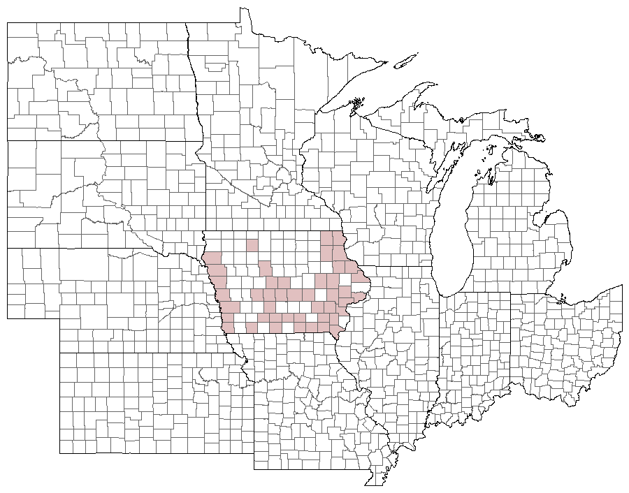
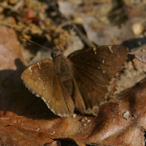
Status: Common breeding resident.
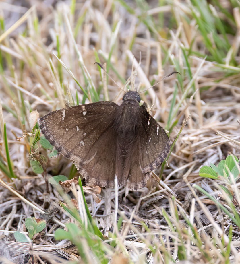
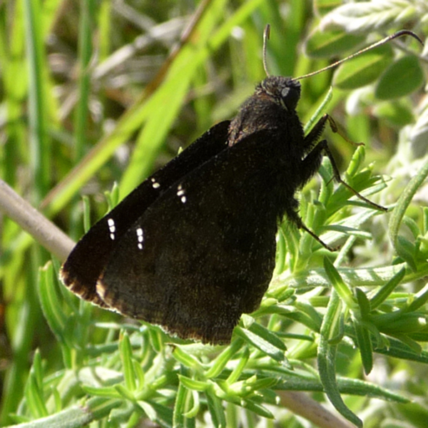
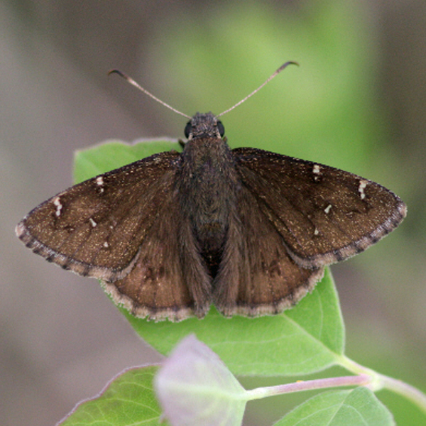
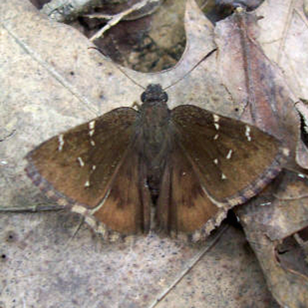
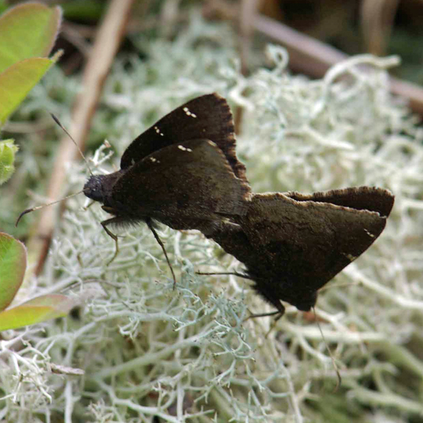
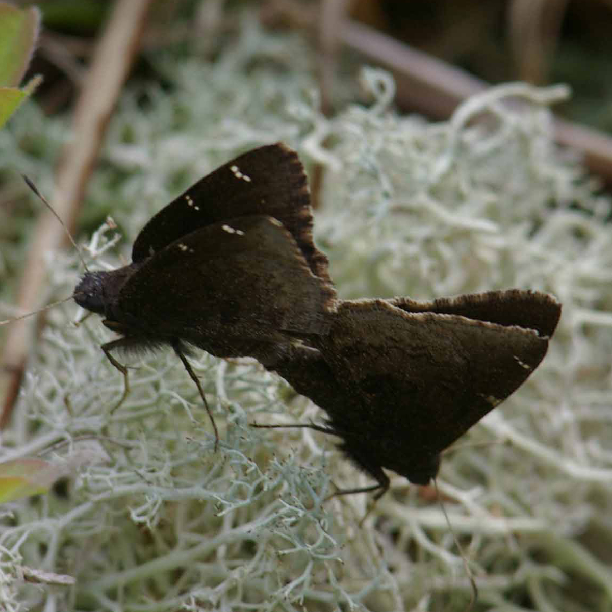
Distinguishing features: Like T. bathyllus, this species is dark brown with white spots on the forewing above and has darker brown bands on the hindwing below. It differs by having narrow, oblong forewing white spots, darker wing fringes, and having hollow (rather than solid) dark-brown hindwing bands. Males possess a costal fold.
Distribution and habitat: This species is relatively frequent in the southern two-thirds of the state. It occurs in a variety of dry, open habitats, including prairies and old-fields.
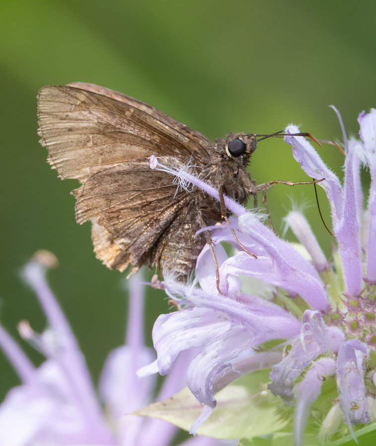
Natural History: The larvae of the Northern Cloudy Wing have been reported to feed on a variety of legumes, including Clover (Trifolium sp.), Bush Clover (Lespedeza sp.), and Tick Trefoils (Desmodium sp.). As these plants are more common in Iowa than those used by T. bathyllus, it is not surprising that T. pylades is the more common of the two.


| Record # | Date | Locale | State | Lat/Lon | Collected By | Count |
|---|---|---|---|---|---|---|
 346322 346322
|
2023-07-08 | Slip Bluff County Park | Iowa | 40.652884 -93.847544 | Jay Gilliam | 1 |
| 350113 | 2023-06-25 | Shimek State Forest, Croton Unit East | IA | 40.545896 -91.616881 | Chris Edwards | 1 |
 346219 346219
|
2023-06-17 | Slip Bluff County Park | Iowa | 40.652884 -93.847544 | Jay Gilliam | 2 |
 346204 346204
|
2023-06-10 | Slip Bluff County Park | Iowa | 40.652884 -93.847544 | Jay Gilliam | 3 |
 346312 346312
|
2023-05-21 | Folsom Point Preserve | Iowa | 41.154432 -95.799393 | Jay Gilliam | 2 |
| 318288 | 2022-07-31 | Folsom Point Preserve | Iowa | 41.154432 -95.799393 | Jay Gilliam | 1 |
| 330731 | 2022-07-12 | Cedar View Trail | Iowa | 40.99102 -92.005082 | IBSN | 1 |
 318010 318010
|
2022-06-19 | Slip Bluff County Park | Iowa | 40.652884 -93.847544 | Jay Gilliam | 1 |
 317954 317954
|
2022-06-18 | Folsom Point Preserve | Iowa | 41.154432 -95.799393 | Jay Gilliam | 9 |
| 331266 | 2022-06-18 | Shimek State Forest, Croton Unit East | Iowa | 40.545896 -91.616881 | Chris Edwards | 2 |
| 330730 | 2022-06-09 | Cedar View Trail | Iowa | 40.99102 -92.005082 | IBSN | 1 |
| 308006 | 2021-06-19 | Shimek State Forest, Croton Unit East | Iowa | 40.545896 -91.616881 | Chris Edwards | 11 |
 300394 300394
|
2021-05-22 | Loess Hills Wildlife Management Area | Iowa | 42.121593 -95.953546 | Jay Gilliam | 1 |
| 286388 | 2020-07-12 | Neal Smith National Wildlife Refuge | Iowa | 41.558756 -93.279723 | IBSN | 1 |
| 286387 | 2020-07-04 | Cedar View Trail | Iowa | 40.990996 -92.004793 | IBSN | 1 |
| 281977 | 2020-07-02 | Coyote Canyon Wildlife Area | Iowa | 41.10032 -93.86014 | Chris Edwards | 2 |
 277885 277885
|
2020-06-21 | Shimek State Forest, Croton Unit East | Iowa | 40.54609014 -91.61590885 | Mark Brown | 1 |
 277886 277886
|
2020-06-21 | Shimek State Forest, Croton Unit East | Iowa | 40.54609014 -91.61590885 | Mark Brown | 1 |
| 281975 | 2020-06-21 | Shimek State Forest, Croton Unit East | Iowa | 40.545896 -91.616881 | Chris Edwards | 11 |
| 281976 | 2020-06-21 | Shimek State Forest, Donnellson Unit | Iowa | 40.643603 -91.67741 | Chris Edwards | 1 |
| 286386 | 2020-06-21 | Cedar View Trail | Iowa | 40.990996 -92.004793 | IBSN | 1 |
 275147 275147
|
2020-06-12 | Slip Bluff County Park | Iowa | 40.652884 -93.847544 | Jay Gilliam | 1 |
| 281974 | 2020-06-12 | Stephens State Forest - Thousand Acre Unit, Monroe County | Iowa | 41.116886 -93.084852 | Chris Edwards | 2 |
| 282347 | 2020-06-12 | Stephens State Forest - Thousand Acre Unit, Lucas County | Iowa | 41.087747 -93.109452 | Chris Edwards | 10 |
| 286385 | 2020-06-12 | Cedar View Trail | Iowa | 40.990996 -92.004793 | IBSN | 1 |
| 281972 | 2020-06-08 | Shimek State Forest, Croton Unit East | Iowa | 40.545896 -91.616881 | Chris Edwards | 3 |
| 286384 | 2020-05-31 | Cedar View Trail | Iowa | 40.990996 -92.004793 | IBSN | 1 |
| 262185 | 2019-06-18 | Cedar View Trail | Iowa | 40.990459 -92.005459 | IBSN | 2 |
| 248682 | 2019-06-16 | Shimek State Forest, Croton Unit East | Iowa | 40.545896 -91.616881 | Chris Edwards | 5 |
| 248719 | 2019-06-16 | Shimek State Forest, Donnellson Unit | Iowa | 40.643603 -91.67741 | Chris Edwards | 1 |
| 262184 | 2019-06-04 | Cedar View Trail | Iowa | 40.990459 -92.005459 | IBSN | 1 |
| 262186 | 2018-06-23 | Thomas Mitchell Park | Iowa | 41.64 -93.3823 | IBSN | 1 |
 225356 225356
|
2018-06-16 | Shimek State Forest, Croton Unit East | Iowa | 40.54693 -91.61435 | Mark Brown | 1 |
| 228626 | 2018-06-16 | Shimek State Forest, Croton Unit East | Iowa | 40.545896 -91.616881 | Chris Edwards | 2 |
| 228538 | 2018-06-03 | Stephens State Forest - Cedar Creek Unit | Iowa | 41.059935 -93.17727 | Chris Edwards | 1 |
| 228568 | 2018-06-03 | Stephens State Forest - Thousand Acre Unit, Lucas County | Iowa | 41.103003 -93.101751 | Chris Edwards | 10 |
| 228481 | 2018-05-28 | Shimek State Forest, Croton Unit East | Iowa | 40.545896 -91.616881 | Chris Edwards | 1 |
| 203163 | 2017-06-24 | Shimek State Forest, Croton Unit East | Iowa | 40.545896 -91.616881 | Chris Edwards | 2 |
| 202208 | 2017-06-07 | Decatur County, Iowa | Iowa | Location Protected | Sibylla Brown | 1 |
| 183821 | 2016-06-18 | Shimek State Forest Count Circle | Iowa | 40.588416 -91.686616 | Chris Edwards | 1 |
| 183842 | 2016-06-18 | Shimek State Forest, Croton Unit East | Iowa | 40.545896 -91.616881 | Chris Edwards | 8 |
| 131441 | 2015-07-10 | Zoll's Mountain Hill Prairie | Iowa | 43.439626 -91.331165 | Frank Olsen | 1 |
| 359313 | 2015-06-25 | Zoll's Mountain Hill Prairie | Iowa | 43.439333 -91.3315 | Kirk J. Larsen | 1 |
| 183511 | 2015-06-21 | Shimek State Forest, Croton Unit East | Iowa | 40.545896 -91.616881 | Chris Edwards | 19 |
| 119432 | 2014-07-03 | Shimek State Forest, Croton Unit East | Iowa | 40.545896 -91.616881 | Chris Edwards | 9 |
| 7496 | 2014-06-25 | Sylvan Runkel State Preserve | Iowa | 42.105 -95.98233 | Aaron Brees | 1 |
| 67761 | 2014-06-25 | Sylvan Runkel State Preserve | Iowa | 42.105 -95.98233 | Aaron Brees | 1 |
| 120408 | 2014-06-16 | Timberhill | Iowa | 40.715921 -93.651635 | Sibylla Brown | 1 |
| 136378 | 2014-06-16 | Decatur County, Iowa | Iowa | Location Protected | Sibylla Brown | 1 |
 67951 67951
|
2014-06-14 | Shimek State Forest, Donnellson Unit | Iowa | 40.6455556 -91.6869444 | Tom Jantscher | 1 |
| 68022 | 2014-06-14 | MacBride Nature Recreation Area | Iowa | 41.787377 -91.560187 | Tom Jantscher | 1 |
| 68046 | 2014-06-14 | MacBride Nature Recreation Area | Iowa | 41.787377 -91.560187 | Tom Jantscher | 1 |
| 68047 | 2014-06-14 | MacBride Nature Recreation Area | Iowa | 41.787377 -91.560187 | Tom Jantscher | 1 |
 67859 67859
|
2014-05-24 | Sylvan Runkel State Preserve | Iowa | 42.10805556 -95.97388889 | Tom Jantscher | 1 |
| 7493 | 2013-06-29 | Stephens State Forest - Woodburn Unit | Iowa | 40.965696 -93.6083756 | Aaron Brees | 1 |
| 10195 | 2013-06-22 | Shimek State Forest, Croton Unit East | Iowa | 40.5405556 -91.6127778 | Tom Jantscher | 1 |
| 10196 | 2013-06-22 | Shimek State Forest, Croton Unit East | Iowa | 40.5422222 -91.6144444 | Tom Jantscher | 1 |
| 10197 | 2013-06-22 | Shimek State Forest, Croton Unit East | Iowa | 40.5422222 -91.6144444 | Tom Jantscher | 1 |
| 10198 | 2013-06-22 | Shimek State Forest, Croton Unit East | Iowa | 40.5458333 -91.6172222 | Tom Jantscher | 1 |
| 10199 | 2013-06-22 | Shimek State Forest, Croton Unit East | Iowa | 40.5463889 -91.6183333 | Tom Jantscher | 1 |
| 119431 | 2013-06-22 | Shimek State Forest, Croton Unit East | Iowa | 40.545896 -91.616881 | Chris Edwards | 5 |
 138342 138342
|
2012-06-02 | Sylvan Runkel State Preserve | Iowa | 42.105 -95.98233 | MJ Hatfield | 1 |
| 119430 | 2011-07-04 | Shimek State Forest, Croton Unit East | Iowa | 40.545896 -91.616881 | Chris Edwards | 1 |
| 119446 | 2011-07-04 | Shimek State Forest, Donnellson Unit | Iowa | 40.643603 -91.67741 | Chris Edwards | 1 |
| 119451 | 2010-06-26 | MacBride Nature Recreation Area | Iowa | 41.786242 -91.566399 | Chris Edwards | 2 |
| 7495 | 2010-05-23 | Sylvan Runkel State Preserve | Iowa | 42.105 -95.98233 | Aaron Brees | 1 |
 207883 207883
|
2010-05-23 | Sylvan Runkel State Preserve | Iowa | 42.102085 -95.971013 | Aaron Brees | 1 |
| 119429 | 2009-06-22 | Shimek State Forest, Croton Unit East | Iowa | 40.545896 -91.616881 | Chris Edwards | 4 |
| 119444 | 2009-06-22 | Shimek State Forest, Farmington Unit | Iowa | 40.653998 -91.72554 | Chris Edwards | 11 |
| 119457 | 2009-06-22 | Shimek State Forest, Donnellson Unit | Iowa | 40.643603 -91.67741 | Chris Edwards | 5 |
| 7494 | 2009-06-18 | Sylvan Runkel State Preserve | Iowa | 42.105 -95.98233 | Aaron Brees | 1 |
| 246733 | 2009-06-18 | Sylvan Runkel State Preserve | Iowa | 42.105 -95.98233 | Aaron Brees | 3 |
 138345 138345
|
2009-06-11 | Allamakee County, Iowa | Iowa | Location Protected | MJ Hatfield | 1 |
 138491 138491
|
2008-06-24 | Stephens State Forest - Cedar Creek Unit | Iowa | 41.063475 -93.173114 | Aaron Brees | 1 |
 207884 207884
|
2008-06-24 | Stephens State Forest - Cedar Creek Unit | Iowa | 41.063278 -93.173157 | Aaron Brees | 1 |
| 119428 | 2008-06-21 | Shimek State Forest, Croton Unit East | Iowa | 40.545896 -91.616881 | Chris Edwards | 6 |
| 119435 | 2008-06-21 | Shimek State Forest, Croton Unit West | Iowa | 40.566286 -91.658401 | Chris Edwards | 17 |
| 119445 | 2008-06-21 | Shimek State Forest, Donnellson Unit | Iowa | 40.643603 -91.67741 | Chris Edwards | 1 |
| 119456 | 2008-06-21 | Shimek State Forest, Donnellson Unit | Iowa | 40.643603 -91.67741 | Chris Edwards | 2 |
| 119450 | 2007-07-14 | MacBride Nature Recreation Area | Iowa | 41.786242 -91.566399 | Chris Edwards | 1 |
| 139311 | 2007-07-10 | Chichaqua Bottoms Greenbelt | Iowa | 41.78688 -93.422013 | IBSN | 2 |
| 119449 | 2007-07-01 | MacBride Nature Recreation Area | Iowa | 41.786242 -91.566399 | Chris Edwards | 1 |
| 119452 | 2007-07-01 | Lake MacBride State Park | Iowa | 41.800146 -91.555669 | Chris Edwards | 3 |
| 119453 | 2007-06-16 | Scales Point | Iowa | 41.803809 -91.589894 | Chris Edwards | 3 |
| 119427 | 2007-06-15 | Shimek State Forest, Croton Unit East | Iowa | 40.545896 -91.616881 | Chris Edwards | 2 |
| 119434 | 2007-06-15 | Shimek State Forest, Croton Unit West | Iowa | 40.566286 -91.658401 | Chris Edwards | 5 |
| 119441 | 2007-06-15 | Shimek State Forest, Lick Creek Unit | Iowa | 40.61233 -91.685905 | Chris Edwards | 1 |
| 119455 | 2007-06-15 | Shimek State Forest, Donnellson Unit | Iowa | 40.643603 -91.67741 | Chris Edwards | 18 |
| 119448 | 2007-06-02 | MacBride Nature Recreation Area | Iowa | 41.786242 -91.566399 | Chris Edwards | 1 |
 110223 110223
|
2007-05-08 | Red River Gorge | Kentucky | 37.79092 -83.592684 | Jim Durbin | 1 |
 110224 110224
|
2007-05-08 | Red River Gorge | Kentucky | 37.79092 -83.592684 | Jim Durbin | 1 |
 185423 185423
|
2007-05-05 | Red River Gorge | Kentucky | 37.79092 -83.592684 | Jim Durbin | 1 |
 185426 185426
|
2007-05-05 | Red River Gorge | Kentucky | 37.79092 -83.592684 | Jim Durbin | 1 |
 144057 144057
|
2006-07-08 | Shimek State Forest, Lick Creek Unit | Iowa | 40.609746 -91.673125 | Mark Brown | 1 |
| 119426 | 2006-06-24 | Shimek State Forest, Croton Unit East | Iowa | 40.545896 -91.616881 | Chris Edwards | 1 |
| 119433 | 2006-06-24 | Shimek State Forest, Croton Unit West | Iowa | 40.566286 -91.658401 | Chris Edwards | 3 |
| 119454 | 2006-06-24 | Shimek State Forest, Donnellson Unit | Iowa | 40.643603 -91.67741 | Chris Edwards | 9 |
 47749 47749
|
2006-05-29 | Leon's Farm, Ohio County | Kentucky | 37.42033 -86.77023 | Jim Durbin | 1 |
 47750 47750
|
2006-05-29 | Leon's Farm, Ohio County | Kentucky | 37.42033 -86.77023 | Jim Durbin | 1 |
 47751 47751
|
2006-05-29 | Leon's Farm, Ohio County | Kentucky | 37.42033 -86.77023 | Jim Durbin | 1 |
 47752 47752
|
2006-05-29 | Leon's Farm, Ohio County | Kentucky | 37.42033 -86.77023 | Jim Durbin | 1 |
| 119440 | 2005-07-02 | Shimek State Forest Count Circle | Iowa | 40.588416 -91.686616 | Chris Edwards | 1 |
| 119425 | 2005-06-12 | Shimek State Forest, Croton Unit East | Iowa | 40.545896 -91.616881 | Chris Edwards | 1 |
| 63345 | 2005-05-30 | Kuehn Connservation Area | Iowa | 41.562794 -94.12889 | Keith Summerville | 1 |
| 119439 | 2004-06-19 | Shimek State Forest Count Circle | Iowa | 40.588416 -91.686616 | Chris Edwards | 7 |
| 119438 | 2003-06-30 | Shimek State Forest Count Circle | Iowa | 40.588416 -91.686616 | Chris Edwards | 5 |
| 119447 | 2003-06-29 | MacBride Nature Recreation Area | Iowa | 41.786242 -91.566399 | Chris Edwards | 1 |
| 63340 | 2002-06-28 | Honey Creek State Park | Iowa | 40.86526 -92.94011 | Frank Olsen | 1 |
| 63341 | 2002-06-27 | Honey Creek State Park | Iowa | 40.86526 -92.94011 | Frank Olsen | 3 |
| 119458 | 2002-06-23 | Hitaga Sand Ridge Prairie Preserve | Iowa | 42.253227 -91.632041 | Chris Edwards | 1 |
| 63364 | 2002-06-22 | Rock Island Botanical State Preserve | Iowa | 42.02732 -91.72723 | Frank Olsen | 1 |
| 119437 | 2002-06-21 | Shimek State Forest Count Circle | Iowa | 40.588416 -91.686616 | Chris Edwards | 3 |
| 119424 | 2002-06-15 | Amborn-Pagin Wildlife Area | Iowa | 40.469571 -91.524545 | Chris Edwards | 1 |
| 119443 | 2002-06-15 | Shimek State Forest, Lick Creek Unit | Iowa | 40.61233 -91.685905 | Chris Edwards | 1 |
| 63363 | 2002-06-13 | Rock Island Botanical State Preserve | Iowa | 42.02732 -91.72723 | Frank Olsen | 1 |
| 271773 | 2002-06-13 | Rock Island Botanical State Preserve | Iowa | 42.02732 -91.72723 | Dennis Schlicht | 1 |
| 63362 | 2002-06-07 | Rock Island Botanical State Preserve | Iowa | 42.02732 -91.72723 | Frank Olsen | 1 |
| 63339 | 2002-06-06 | Honey Creek State Park | Iowa | 40.86526 -92.94011 | Dennis Schlicht | 1 |
| 63338 | 2002-05-26 | Honey Creek State Park | Iowa | 40.86526 -92.94011 | Dennis Schlicht | 1 |
| 63342 | 2002-05-15 | Honey Creek State Park | Iowa | 40.86526 -92.94011 | Frank Olsen | 1 |
| 119442 | 2001-06-30 | Shimek State Forest, Lick Creek Unit | Iowa | 40.61233 -91.685905 | Chris Edwards | 2 |
| 119436 | 2001-06-18 | Shimek State Forest Count Circle | Iowa | 40.588416 -91.686616 | Chris Edwards | 7 |
| 63400 | 1998-07-01 | Winneshiek County | Iowa | 43.23626 -91.90993 | 1 | |
| 353301 | 1998-07-01 | Anderson Prairie, Decorah | Iowa | 43.315099 -91.800701 | Jennifer Bovee | 1 |
| 63344 | 1994-07-03 | Indian Creek Nature Center | Iowa | 41.9664 -91.5806 | Frank Olsen | 1 |
| 246732 | 1994-07-03 | Indian Creek Nature Center | Iowa | 41.968932 -91.586884 | Frank Olsen | 2 |
| 63343 | 1994-06-25 | Indian Creek Nature Center | Iowa | 41.9664 -91.5806 | Frank Olsen | 1 |
 144462 144462
|
1994-06-25 | Indian Creek Nature Center | Iowa | 41.96611 -91.57934 | Frank Olsen | 1 |
| 271930 | 1994-06-25 | Fayette County | Iowa | 0 0 | Ron Harms | 21 |
| 63347 | 1994-06-04 | Loess Hills Wildlife Management Area | Iowa | 42.08 -95.9765 | Ron Harms | 1 |
| 63337 | 1992-06-27 | Hitaga Sand Ridge Prairie Preserve | Iowa | 42.25233 -91.63633 | Frank Olsen | 1 |
| 63336 | 1992-06-20 | Hitaga Sand Ridge Prairie Preserve | Iowa | 42.25233 -91.63633 | Frank Olsen | 1 |
 144407 144407
|
1992-06-20 | Hitaga Sand Ridge Prairie Preserve | Iowa | 42.24944 -91.63056 | Frank Olsen | 1 |
| 246731 | 1992-06-20 | Hitaga Sand Ridge Prairie Preserve | Iowa | 42.252252 -91.63345 | Frank Olsen | 3 |
 144404 144404
|
1992-06-13 | Rock Island Botanical State Preserve | Iowa | 42.026205 -91.726516 | Frank Olsen | 1 |
| 63354 | 1992-06-12 | Rock Island Botanical State Preserve | Iowa | 42.02732 -91.72723 | Frank Olsen | 1 |
| 108004 | 1992-06-12 | Mount Talbot State Preserve | Iowa | 42.564435 -96.469674 | Tim Orwig | 1 |
| 63361 | 1991-06-29 | Rock Island Botanical State Preserve | Iowa | 42.02732 -91.72723 | Frank Olsen | 1 |
| 63360 | 1991-06-24 | Rock Island Botanical State Preserve | Iowa | 42.02732 -91.72723 | Frank Olsen | 1 |
 144371 144371
|
1991-06-24 | Rock Island Botanical State Preserve | Iowa | 42.026205 -91.726516 | Frank Olsen | 1 |
| 63383 | 1991-06-08 | Wanatee County Park | Iowa | 42.00994 -91.57749 | Frank Olsen | 1 |
| 144358 | 1991-06-08 | Wanatee County Park | Iowa | 42.00994 -91.57749 | Frank Olsen | 1 |
| 246730 | 1991-06-08 | Wanatee County Park | Iowa | 42.00994 -91.57749 | Frank Olsen | 2 |
| 63348 | 1991-05-31 | Loess Hills Wildlife Management Area | Iowa | 42.08 -95.9765 | Ron Harms | 1 |
| 63392 | 1991-05-26 | War Eagle Park | Iowa | 42.49332 -96.4508 | Tim Orwig | 1 |
| 108003 | 1991-05-26 | Riverside Bluff | Iowa | 42.512811 -96.47187 | Tim Orwig | 1 |
| 246729 | 1991-05-26 | War Eagle Park | Iowa | 42.49332 -96.4508 | Tim Orwig | 2 |
| 63357 | 1990-07-04 | Rock Island Botanical State Preserve | Iowa | 42.02732 -91.72723 | Frank Olsen | 1 |
| 246728 | 1990-07-04 | Rock Island Botanical State Preserve | Iowa | 42.0275 -91.7286111 | Frank Olsen | 2 |
| 124780 | 1990-07-01 | Wanatee County Park | Iowa | 42.00994 -91.57749 | Frank Olsen | 2 |
 144310 144310
|
1990-06-30 | Rock Island Botanical State Preserve | Iowa | 42.026205 -91.726516 | Frank Olsen | 1 |
| 63359 | 1990-06-25 | Rock Island Botanical State Preserve | Iowa | 42.02732 -91.72723 | Frank Olsen | 1 |
| 63393 | 1990-06-25 | Waubonsie State Park | Iowa | 40.676 -95.689 | Tim Orwig | 1 |
| 63334 | 1990-06-24 | Geode State Park | Iowa | 40.81944 -91.39194 | Tim Orwig | 1 |
| 246727 | 1990-06-24 | Geode State Park | Iowa | 40.823969 -91.378233 | Tim Orwig | 2 |
| 63358 | 1989-07-16 | Rock Island Botanical State Preserve | Iowa | 42.02732 -91.72723 | Frank Olsen | 1 |
| 124464 | 1989-07-16 | Rock Island Botanical State Preserve | Iowa | 42.02732 -91.72723 | Frank Olsen | 1 |
| 63356 | 1989-07-14 | Rock Island Botanical State Preserve | Iowa | 42.02732 -91.72723 | Frank Olsen | 1 |
| 124449 | 1989-07-14 | Rock Island Botanical State Preserve | Iowa | 42.02732 -91.72723 | Frank Olsen | 2 |
| 246726 | 1989-07-14 | Rock Island Botanical State Preserve | Iowa | 42.0275 -91.7286111 | Frank Olsen | 2 |
| 63355 | 1989-07-01 | Rock Island Botanical State Preserve | Iowa | 42.02732 -91.72723 | Frank Olsen | 1 |
| 124431 | 1989-07-01 | Rock Island Botanical State Preserve | Iowa | 42.02732 -91.72723 | Frank Olsen | 1 |
 144269 144269
|
1989-07-01 | Rock Island Botanical State Preserve | Iowa | 42.026205 -91.726516 | Frank Olsen | 1 |
 144270 144270
|
1989-07-01 | Rock Island Botanical State Preserve | Iowa | 42.026205 -91.726516 | Frank Olsen | 1 |
| 246725 | 1989-07-01 | Rock Island Botanical State Preserve | Iowa | 42.0275 -91.7286111 | Frank Olsen | 2 |
| 63385 | 1989-06-12 | Stone State Park | Iowa | 42.55333 -96.46194 | Tim Orwig | 1 |
| 63386 | 1989-05-25 | Stone State Park | Iowa | 42.55333 -96.46194 | Tim Orwig | 1 |
| 63351 | 1989-05-17 | Loess Hills Wildlife Management Area | Iowa | 42.08 -95.9765 | Tim Orwig | 1 |
| 63353 | 1989-05-17 | Loess Hills Wildlife Management Area | Iowa | 42.08 -95.9765 | Tim Orwig | 1 |
 144212 144212
|
1988-07-26 | Waubonsie State Park | Iowa | 40.676 -95.689 | Frank Olsen | 1 |
| 63365 | 1988-06-23 | Shimek State Forest, Croton Unit East | Iowa | 40.54693 -91.61435 | Tim Orwig | 1 |
| 63366 | 1988-06-23 | Shimek State Forest, Croton Unit East | Iowa | 40.54693 -91.61435 | Tim Orwig | 1 |
| 63367 | 1988-06-23 | Shimek State Forest, Croton Unit East | Iowa | 40.54693 -91.61435 | Tim Orwig | 1 |
| 63368 | 1988-06-23 | Shimek State Forest, Croton Unit East | Iowa | 40.54693 -91.61435 | Tim Orwig | 1 |
| 63349 | 1988-06-04 | Loess Hills Wildlife Management Area | Iowa | 42.08 -95.9765 | Tim Orwig | 1 |
| 63350 | 1988-06-04 | Loess Hills Wildlife Management Area | Iowa | 42.08 -95.9765 | Tim Orwig | 1 |
| 63352 | 1988-06-04 | Loess Hills Wildlife Management Area | Iowa | 42.08 -95.9765 | Tim Orwig | 1 |
| 108002 | 1988-06-04 | Monona County | Iowa | 42.050426 -95.953652 | Tim Orwig | 1 |
| 63394 | 1988-06-02 | Waubonsie State Park | Iowa | 40.676 -95.689 | Tim Orwig | 1 |
| 63395 | 1988-06-02 | Waubonsie State Park | Iowa | 40.676 -95.689 | Tim Orwig | 1 |
| 63396 | 1988-06-02 | Waubonsie State Park | Iowa | 40.676 -95.689 | Tim Orwig | 1 |
| 63397 | 1988-06-02 | Waubonsie State Park | Iowa | 40.676 -95.689 | Tim Orwig | 1 |
| 63387 | 1988-05-27 | Stone State Park | Iowa | 42.55383 -96.4665 | Tim Orwig | 1 |
| 63388 | 1988-05-27 | Stone State Park | Iowa | 42.55383 -96.4665 | Tim Orwig | 1 |
| 63389 | 1988-05-27 | Stone State Park | Iowa | 42.55383 -96.4665 | Tim Orwig | 1 |
| 63373 | 1988-05-26 | Sioux City State Prairie Preserve | Iowa | 42.5241 -96.4362 | Tim Orwig | 1 |
| 63376 | 1988-05-26 | Sioux City State Prairie Preserve | Iowa | 42.5241 -96.4362 | Tim Orwig | 1 |
| 63382 | 1988-05-26 | Sioux City State Prairie Preserve | Iowa | 42.5241 -96.4362 | Tim Orwig | 1 |
| 63372 | 1988-05-24 | Sioux City State Prairie Preserve | Iowa | 42.5241 -96.4362 | Tim Orwig | 1 |
| 63375 | 1988-05-24 | Sioux City State Prairie Preserve | Iowa | 42.5241 -96.4362 | Tim Orwig | 1 |
| 63377 | 1988-05-24 | Sioux City State Prairie Preserve | Iowa | 42.5241 -96.4362 | Tim Orwig | 1 |
| 63380 | 1988-05-24 | Sioux City State Prairie Preserve | Iowa | 42.5241 -96.4362 | Tim Orwig | 1 |
| 63390 | 1988-05-21 | Broken Kettle Grasslands Preserve | Iowa | 42.71583 -96.55333 | Tim Orwig | 1 |
| 63391 | 1988-05-21 | Broken Kettle Grasslands Preserve | Iowa | 42.71583 -96.55333 | Tim Orwig | 1 |
| 108005 | 1988-05-21 | Deer Creek Wildlife Management Area | Iowa | 42.715241 -96.526718 | Tim Orwig | 1 |
| 63369 | 1988-05-19 | Sioux City State Prairie Preserve | Iowa | 42.5241 -96.4362 | Tim Orwig | 1 |
| 63371 | 1988-05-19 | Sioux City State Prairie Preserve | Iowa | 42.5241 -96.4362 | Tim Orwig | 1 |
| 63374 | 1988-05-19 | Sioux City State Prairie Preserve | Iowa | 42.5241 -96.4362 | Tim Orwig | 1 |
| 63379 | 1988-05-19 | Sioux City State Prairie Preserve | Iowa | 42.5241 -96.4362 | Tim Orwig | 1 |
| 107999 | 1987-07-10 | Big Sand Mound Prairie Preserve, Muscatine County | Iowa | 41.341015 -91.086545 | Dennis Schlicht | 1 |
| 63333 | 1987-06-11 | Allamakee County | Iowa | 43.2544 -91.38097 | J. Nehuevaj | 1 |
| 63370 | 1987-06-04 | Sioux City State Prairie Preserve | Iowa | 42.5241 -96.4362 | Tim Orwig | 1 |
| 63381 | 1987-06-04 | Sioux City State Prairie Preserve | Iowa | 42.5241 -96.4362 | Tim Orwig | 1 |
| 108000 | 1987-05-30 | Turin | Iowa | 42.019382 -95.966404 | Tim Orwig | 1 |
| 108001 | 1987-05-30 | Turin | Iowa | 42.019382 -95.966404 | Tim Orwig | 1 |
| 63335 | 1987-05-29 | Harrison County | Iowa | 41.80943 -96.02112 | Jeff Nekola | 1 |
| 63378 | 1986-06-01 | Sioux City State Prairie Preserve | Iowa | 42.5241 -96.4362 | Tim Orwig | 1 |
| 63346 | 1961-07-02 | Shimek State Forest, Croton Unit East | Iowa | 40.54575 -91.61623 | St. Ambrose Univ. | 1 |
| 63398 | 1961-07-01 | Wildcat Den State Park | Iowa | 41.4705 -90.88228 | St. Ambrose Univ. | 1 |
| 63399 | 1961-06-12 | Wildcat Den State Park | Iowa | 41.4705 -90.88228 | St. Ambrose Univ. | 1 |
| 6130 | 1950-06-20 | Allamakee County | Iowa | 43.243076 -91.443466 | USGS - NPWRC | 1 |
| 6131 | 1950-06-20 | Benton County | Iowa | 42.138725 -92.066521 | USGS - NPWRC | 1 |
| 6132 | 1950-06-20 | Boone County | Iowa | 42.088177 -93.987846 | USGS - NPWRC | 1 |
| 6133 | 1950-06-20 | Cedar County | Iowa | 41.834614 -91.1353 | USGS - NPWRC | 1 |
| 6134 | 1950-06-20 | Clarke County | Iowa | 41.017784 -93.784149 | USGS - NPWRC | 1 |
| 6135 | 1950-06-20 | Clayton County | Iowa | 42.77853 -91.289101 | USGS - NPWRC | 1 |
| 6136 | 1950-06-20 | Davis County | Iowa | 40.691383 -92.381363 | USGS - NPWRC | 1 |
| 6137 | 1950-06-20 | Decatur County | Iowa | 40.814648 -93.824821 | USGS - NPWRC | 1 |
| 6138 | 1950-06-20 | Delaware County | Iowa | 42.463402 -91.443466 | USGS - NPWRC | 1 |
| 6139 | 1950-06-20 | Dubuque County | Iowa | 42.469467 -90.829399 | USGS - NPWRC | 1 |
| 6140 | 1950-06-20 | Sidney | Iowa | 40.74004 -95.645798 | USGS - NPWRC | 1 |
| 6141 | 1950-06-20 | Guthrie County | Iowa | 41.75309 -94.479973 | USGS - NPWRC | 1 |
| 6142 | 1950-06-20 | Harrison County | Iowa | 41.693386 -95.814285 | USGS - NPWRC | 1 |
| 6143 | 1950-06-20 | Henry County | Iowa | 41.028358 -91.598396 | USGS - NPWRC | 1 |
| 6144 | 1950-06-20 | Jackson County | Iowa | 42.156071 -90.52578 | USGS - NPWRC | 1 |
| 6145 | 1950-06-20 | Johnson County | Iowa | 41.669899 -91.598396 | USGS - NPWRC | 1 |
| 6146 | 1950-06-20 | Keokuk County | Iowa | 41.339706 -92.223663 | USGS - NPWRC | 1 |
| 6147 | 1950-06-20 | Lee County | Iowa | 40.706867 -91.443466 | USGS - NPWRC | 1 |
| 6148 | 1950-06-20 | Linn County | Iowa | 42.027289 -91.67275 | USGS - NPWRC | 1 |
| 6149 | 1950-06-20 | Louisa County | Iowa | 41.193298 -91.289101 | USGS - NPWRC | 1 |
| 6150 | 1950-06-20 | Lucas County | Iowa | 40.991203 -93.33889 | USGS - NPWRC | 1 |
| 6151 | 1950-06-20 | Madison County | Iowa | 41.292236 -93.987846 | USGS - NPWRC | 1 |
| 6152 | 1950-06-20 | Mills County | Iowa | 41.06245 -95.645798 | USGS - NPWRC | 1 |
| 6153 | 1950-06-20 | Monona County | Iowa | 42.001595 -95.983261 | USGS - NPWRC | 1 |
| 6154 | 1950-06-20 | Muscatine County | Iowa | 41.51569 -91.1353 | USGS - NPWRC | 1 |
| 6155 | 1950-06-20 | Palo Alto County | Iowa | 43.158089 -94.645035 | USGS - NPWRC | 1 |
| 6156 | 1950-06-20 | Plymouth County | Iowa | 42.776665 -96.152695 | USGS - NPWRC | 1 |
| 6157 | 1950-06-20 | Polk County | Iowa | 41.627842 -93.500343 | USGS - NPWRC | 1 |
| 6158 | 1950-06-20 | Pottawattamie County | Iowa | 41.391151 -95.477783 | USGS - NPWRC | 1 |
| 6159 | 1950-06-20 | Poweshiek County | Iowa | 41.653011 -92.539604 | USGS - NPWRC | 1 |
| 6160 | 1950-06-20 | Scott County | Iowa | 41.63932 -90.639374 | USGS - NPWRC | 1 |
| 6161 | 1950-06-20 | Story County | Iowa | 42.104046 -93.500343 | USGS - NPWRC | 1 |
| 6162 | 1950-06-20 | Taylor County | Iowa | 40.784607 -94.645035 | USGS - NPWRC | 1 |
| 6163 | 1950-06-20 | Union County | Iowa | 41.000687 -94.274361 | USGS - NPWRC | 1 |
| 6164 | 1950-06-20 | Van Buren County | Iowa | 40.700115 -91.909927 | USGS - NPWRC | 1 |
| 6165 | 1950-06-20 | Washington County | Iowa | 41.347797 -91.753883 | USGS - NPWRC | 1 |
| 6166 | 1950-06-20 | Webster County | Iowa | 42.397495 -94.151375 | USGS - NPWRC | 1 |
| 6167 | 1950-06-20 | Winneshiek County | Iowa | 43.236259 -91.909927 | USGS - NPWRC | 1 |
| 6168 | 1950-06-20 | Woodbury County | Iowa | 42.316616 -95.983261 | USGS - NPWRC | 1 |
| 63384 | 1930-06-21 | Stone State Park | Iowa | 42.55333 -96.46194 | Tim Orwig | 1 |